
Kowloon is an urban area in Hong Kong comprising the Kowloon Peninsula and New Kowloon. It has a population of 2,019,533 and a population density of 43,033/km2 (111,450/sq mi) in 2006. It is one of the three regions of Hong Kong, along with Hong Kong Island and the New Territories, and is the smallest, second most populous and most densely populated.

Most of the walled villages of Hong Kong are located in the New Territories.

Ho Man Tin is a mostly residential area in Kowloon, Hong Kong, part of the Kowloon City District.
Tai Wai is an area in the New Territories, Hong Kong, located between Sha Tin and the Lion Rock, within the Sha Tin District.

Sheung Shui is an area in the New Territories, Hong Kong. Sheung Shui Town, a part of this area, is part of the Fanling–Sheung Shui New Town in the North District of Hong Kong. Fanling Town is to its southeast.

To Kwa Wan is a bay and an area of the eastern shore of Kowloon peninsula. The area is part of urban Hong Kong, and is situated between Hok Yuen, Hung Hom, Ma Tau Chung and Ma Tau Kok. Administratively, the area belongs to the Kowloon City District of Kowloon.

Argyle Street is a four-lane dual-way thoroughfare in Kowloon, Hong Kong, connecting the districts of Mong Kok, Ho Man Tin, Ma Tau Wai and Kowloon City. It runs on an east-west alignment starting at its intersection with Cherry Street, Ferry Street and Tong Mi Road in the west, and ending near the former Kai Tak Airport in the east. Due to the street's proximity with the latter, a variety of aircraft could be seen from this street and thus photographers seized the opportunity to capture landing aircraft.

Ma Tau Kok is a place north of To Kwa Wan, south-east of modern-day Ma Tau Chung and south-west of the former Kai Tak Airport in Hong Kong. It was a cape in Kowloon Bay in Victoria Harbour and opposite to the Sacred Hill and the mouth of Ma Tau Chung. Ma Tau Kok is a mixed industrial and residential area.

Ma Tau Chung is an area in Kowloon, Hong Kong, west of Ma Tau Kok and east of Ma Tau Wai. It was named after a creek which originated in Quarry Hill emptying into Kowloon Bay. The village of Ma Tau Chung stood on its banks near the river mouth near the Sacred Hill.
Kau Pui Lung, formerly Kau Pui Loong or Hau Pui Loong, is a valley and an area between Ma Tau Wai and To Kwa Wan, and west of Ma Tau Chung in Kowloon of Hong Kong. The area now full of schools near the junction of Kau Pui Lung Road and Tin Kwong Road, as well as along Farm Road, where Heep Yunn School is located.

Sung Wong Toi is an underground MTR rapid transit station in Hong Kong on the Tuen Ma line, located in Ma Tau Chung in Kowloon City District. The station also serves Kowloon City and Ma Tau Wai via a pedestrian tunnel. The station was built as part of the Sha Tin to Central Link (SCL), and opened on 27 June 2021 along with the rest of phase 2 of the Tuen Ma line. The station was constructed by a Samsung–Hsin Chong joint venture.
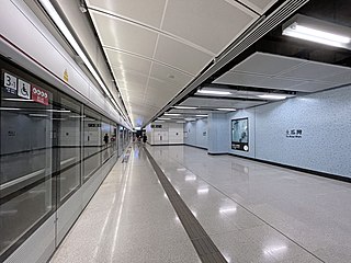
To Kwa Wan is an underground MTR rapid transit station in Hong Kong on the Tuen Ma line. It is located beneath Ma Tau Wai Road in central To Kwa Wan, Kowloon City District. The station was built as part of the Sha Tin to Central Link (SCL) project, and opened on 27 June 2021 along with the rest of phase 2 of the Tuen Ma line. The station was constructed by a Samsung–Hsin Chong joint venture.

Celestial Heights is a private housing estate on Quarry Hill in Kowloon, Hong Kong, jointly developed by Cheung Kong Holdings and Nan Fung Group near To Kwa Wan station. There are 939 housing units, with an average price of HK$19,000,000. It is composed of several more-than-50-floor buildings. It was completed in 2009 and 2010.

Ma Tau Wai Estate is a public housing estate in Ma Tau Wai, Kowloon, Hong Kong. It is the oldest existing public housing estate in Kowloon City District and it consists of five residential blocks completed in 1962 and 1965. Although it was developed by Hong Kong Housing Authority, it is currently managed by Hong Kong Housing Society.
The following is an overview of public housing estates in Hung Hom, To Kwa Wan and Ma Tau Wai, of Kowloon City District, Hong Kong, including Home Ownership Scheme (HOS), Private Sector Participation Scheme (PSPS), and Tenant Purchase Scheme (TPS) estates.

Holy Trinity Cathedral, in Kowloon, Hong Kong, is a cathedral for the Anglican Eastern Kowloon diocese. It was established in 1890, making it one of the oldest Anglican churches in Hong Kong. The cathedral is one of the three Anglican cathedrals of the Hong Kong Anglican church.

Ma Tau Wai Road is a main road in Kowloon City District, Kowloon, Hong Kong.
Ma Tau Chung Camp was an internment camp in Ma Tau Chung, Hong Kong during the Japanese Occupation of Hong Kong during World War II.

