

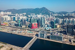
To Kwa Wan Road is a major thoroughfare in To Kwa Wan, Kowloon, Hong Kong, connecting To Kwa Wan with Ma Tau Kok.
To Kwa Wan Road is a major thoroughfare in To Kwa Wan, Kowloon, Hong Kong, connecting To Kwa Wan with Ma Tau Kok.
| Kowloon City | |
|---|---|
| Kwun Tong | |
| Sham Shui Po | |
| Wong Tai Sin | |
| Yau Tsim Mong | |
| |
| | This Hong Kong road article is a stub. You can help Wikipedia by expanding it. |

Kowloon is an urban area in Hong Kong comprising the Kowloon Peninsula and New Kowloon. It has a population of 2,019,533 and a population density of 43,033/km2 (111,450/sq mi) in 2006. It is one of the three areas of Hong Kong, along with Hong Kong Island and the New Territories. It is the smallest, second most populous and most densely populated of the divisions.
Kowloon Bay is a bay within Victoria Harbour and an neighbourhood within Kowloon, Hong Kong.

Hoi Sham Island, also called To Kwa Wan Island (土瓜灣島), was an island in Kowloon Bay off the coast of To Kwa Wan, Kowloon Peninsula in Hong Kong. It was connected to the mainland as a consequence of land reclamation, and it is now part of Hoi Sham Park (海心公園).

To Kwa Wan is a bay and an area of the eastern shore of Kowloon peninsula. The area is part of urban Hong Kong, and is situated between Hok Yuen, Hung Hom, Ma Tau Chung and Ma Tau Kok. Administratively, the area belongs to the Kowloon City District of Kowloon.

Ma Tau Wai is an area in the Kowloon City District, Kowloon, Hong Kong. It was originally a walled village between present-day Argyle Street and Prince Edward Road West, east of present-day St. Teresa's Hospital.

Cheung Sha Wan is an area between Lai Chi Kok and Sham Shui Po in New Kowloon, Hong Kong. It is mainly residential to the north and south, with an industrial area in between. Administratively it is part of Sham Shui Po District, which also includes Lai Chi Kok.
Ma Tau Kok is a place north of To Kwa Wan, south-east of modern-day Ma Tau Chung and south-west of the former Kai Tak Airport in Hong Kong. It was a cape in Kowloon Bay in Victoria Harbour and opposite to the Sacred Hill and the mouth of Ma Tau Chung. Ma Tau Kok is a mixed industrial and residential area.

Chatham Road South and Chatham Road North are two continuous roads extending from Tsim Sha Tsui to Hung Hom in Kowloon, Hong Kong. The road originally ran from Signal Hill to Hung Hom, under No. 12 Hill by the side of Hung Hom Bay. It was later extended through Lo Lung Hang to the southern end of To Kwa Wan, which makes up Chatham Road North.

Tai Wan was a bay on the eastern Hung Hom, Kowloon Peninsula in Hong Kong. The southern end of the bay joined with the Hong Kong and Whampoa Dock. The name also refers to an area, which neighbours To Kwa Wan and the Whampoa Garden in Hung Hom.

Kellett Bay, or Kai Lung Wan (雞籠灣) is a bay on southwestern Hong Kong Island in Hong Kong, to the southeast of Waterfall Bay.
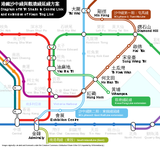
The Sha Tin to Central Link was an expansion project of the MTR public transport network in Hong Kong. It was divided into two sections and expanded the network’s heavy rail lines.
Kau Pui Lung, formerly Kau Pui Loong or Hau Pui Loong, is a valley and area between Ma Tau Wai and To Kwa Wan, and west of Ma Tau Chung in Kowloon of Hong Kong. The area now full of schools near the junction of Kau Pui Lung Road and Tin Kwong Road, as well as along Farm Road, where Heep Yunn School is located.

East Kowloon Corridor is a motorway in Kowloon, Hong Kong. Part of Route 5, it is a dual two-lane carriageway viaduct running from the western exit of Kai Tak Tunnel near Sung Wong Toi Road to its ramp on Chatham Road North between Lo Lung Hang Hill and the western side of Hung Hom, to the northnortheast of Fat Kwong Street Flyover.

Sung Wong Toi is an underground MTR rapid transit station in Hong Kong on the Tuen Ma line, located in Ma Tau Chung in Kowloon City District. The station also serves Kowloon City and Ma Tau Wai via a pedestrian tunnel. The station was built as part of the Sha Tin to Central Link (SCL), and opened on 27 June 2021 along with the rest of phase 2 of the Tuen Ma line. The station was constructed by a Samsung–Hsin Chong joint venture.

To Kwa Wan is an underground MTR rapid transit station in Hong Kong on the Tuen Ma line. It is located beneath Ma Tau Wai Road in central To Kwa Wan, Kowloon City District. The station was built as part of the Sha Tin to Central Link (SCL) project, and opened on 27 June 2021 along with the rest of phase 2 of the Tuen Ma line. The station was constructed by a Samsung–Hsin Chong joint venture. When the station was originally being built, the planned name of the station was Mau Tau Wai before being changed to its current one in 2017.
The following is an overview of public housing estates in Hung Hom, To Kwa Wan and Ma Tau Wai, of Kowloon City District, Hong Kong, including Home Ownership Scheme (HOS), Private Sector Participation Scheme (PSPS), and Tenant Purchase Scheme (TPS) estates.
The 13 Streets is an area in Ma Tau Kok, Kowloon City District, Hong Kong. It consists of rows of late 1950s tenement buildings along 11 parallel short streets named after auspicious animals. The area is known for its abundance of ground floor garages.