
Kowloon is an urban area in Hong Kong comprising the Kowloon Peninsula and New Kowloon. With a population of 2,019,533 and a population density of 43,033/km2 (111,450/sq mi) in 2006, it is the most populous area in Hong Kong, compared with Hong Kong Island and the rest of the New Territories. The peninsula's area is about 47 km2 (18 sq mi).

West Kowloon is the western part of Kowloon Peninsula in Hong Kong, situated within the Yau Tsim Mong District and Sham Shui Po District. It is bounded by Canton Road to the east, Victoria Harbour to the west and the south, and Jordan Road to the north. Further to the north, the area extends to Tai Kok Tsui to the west of the West Kowloon Highway. Nam Cheong, Olympic, Austin and Kowloon stations are within the area.
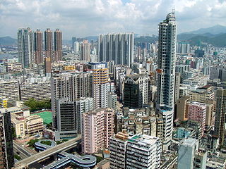
Tai Kok Tsui is an area west of Mong Kok in Kowloon, Hong Kong. The mixed land use of industrial and residential is present in the old area. The Cosmopolitan Dock and oil depots were previously located there. Blocks of high-rise residential buildings have been erected on the reclaimed area to the west, which marked the revitalisation of the area with many restaurants and bars setting up shop. Many of the older residential buildings have been vacated and are set to be replaced by high-rise residential and commercial buildings.

West Kowloon Highway is a section of Route 3 in Hong Kong, built as part of the Airport Core Programme. This dual-three-lane expressway runs for 4.2 km (2.6 mi), connecting Western Harbour Crossing in the south with Tsing Kwai Highway in the north. While the southern section of the road is at grade, the northern part is on a viaduct in order to accommodate the MTR Tung Chung line and the Airport Express.

Argyle Street is a four-lane dual-way thoroughfare in Kowloon, Hong Kong, connecting the districts of Mong Kok, Ho Man Tin, Ma Tau Wai and Kowloon City. It runs on an east-west alignment starting at its intersection with Cherry Street, Ferry Street and Tong Mi Road in the west, and ending near the former Kai Tak Airport in the east. Due to the street's proximity with the latter, a variety of aircraft could be seen from this street and thus photographers seized the opportunity to capture landing aircraft.

Sai Wan, also known as Western district, or simply Western, is an area in Hong Kong Island, Hong Kong that corresponds to Sai Ying Pun, Shek Tong Tsui, Belcher Bay and Kennedy Town. However, Some Hong Kong people consider Kennedy Town as the only part of Sai Wan. It formed part of the City of Victoria. West Point, a former cape where major government structures in Sai Wan are close to, also used to refer to Sai Wan.

Ferry Point, also known as Austin, is an area located on the west of Jordan, Kowloon, Hong Kong. It was at the seafront and adjacent to former Jordan Road Ferry Pier. However, after reclamation, the ferry pier was then demolished and the name Austin is frequently used instead of Ferry Point.

West Kowloon Corridor is part of Route 5 in Hong Kong. Bypassing existing surface roads in West Kowloon, it connects Lai Chi Kok Road in Cheung Sha Wan with the Gascoigne Road Flyover near Yau Ma Tei.

Lai Chi Kok Road is a road in western Kowloon, Hong Kong. It links Lai Chi Kok to Mong Kok, via Tai Kok Tsui, Sham Shui Po and Cheung Sha Wan. It starts from a junction with Nathan Road near Pioneer Centre in the south and ends near Mei Foo Sun Chuen. The road is bidirectional except the section at Lai Chi Kok, between the junction with Butterfly Valley Road and Mei Foo Sun Chuen, where it serves New Territories-bound traffic only. The Kowloon-bound traffic uses Cheung Sha Wan Road, separated by the flyover of Kwai Chung Road. The road once hosted shipyards, fish, meat and vegetable wholesale markets, which were moved closer to the coast after extensive reclamation.

Middle Road is a street in the southern part of Tsim Sha Tsui, Kowloon, Hong Kong.

Prince Edward Road East and Prince Edward Road West are roads in Kowloon, Hong Kong, going in an east-west direction and linking Tai Kok Tsui, Mong Kok, Kowloon Tong, Kowloon City and San Po Kong.

Kwun Tong Road is a major thoroughfare in Kwun Tong District, New Kowloon, Hong Kong.
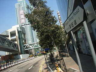
Sham Mong Road is a major road on the new reclamation of the 1990s in western Kowloon and New Kowloon of Hong Kong.

Jordan Road Ferry Pier or Ferry Point (1924–1998) is a demolished pier originally located at Jordan Road, Jordan, Hong Kong.
Mong Kok Ferry Pier (1924–1972) was a ferry pier to the west of Shantung Street, Mong Kok, Kowloon, Hong Kong, located inside the old Yau Ma Tei Typhoon Shelter. The site was covered over during land reclamation under the West Kowloon Reclamation Project.
Tai Kok Tsui Ferry Pier (1972–1992) was a ferry pier in Tai Kok Tsui, Kowloon, Hong Kong. It started operation in 1972, together with an adjacent bus terminus, to replace the Mong Kok Ferry Pier in Mong Kok. It provided a ferry service to and from Central, Hong Kong and Guangzhou, Mainland China. Its cross-boundary ferry terminal position was replaced by the Hong Kong China Ferry Terminal in Tsim Sha Tsui in 1988. It was then closed in 1992 to cope with land reclamation work for the Airport Core Programme. The bus terminus remained in use until it was relocated to a new reclaimed area in west Tai Kok Tsui in 1995. The pier has been reclaimed and the HSBC Centre now stands where the former bus terminal used to be.

Sham Shui Po Ferry Pier was a ferry pier in Sham Shui Po, Kowloon, Hong Kong that operated from 1924 to 1992. It was one of the important ferry piers in West Kowloon and had a bus terminus nearby.

Florient Rise is a private housing estate in Cherry Street, Tai Kok Tsui, Yau Tsim Mong District, Kowloon, Hong Kong near Olympic station. It was jointly developed by Nan Fung Group and Urban Renewal Authority (URA) in 2008 and completed the construction in May 2009. It comprises three blocks with a total of 522 units.

Metro Harbour View is a private housing estate at the intersection of Tai Kok Tsui Road and Fuk Lee Street in Tai Kok Tsui, Kowloon, Hong Kong, within walking distance to the MTR Olympic station.

The Hung Shing Temple, Tai Kok Tsui or Hung Shing Temple, Fuk Tsun Street (福全街洪圣庙) is a Hung Shing Temple located at No. 58 Fuk Tsun Street (福全街), in the Tai Kok Tsui area of Hong Kong. It is the only Hung Shing temple in urban Kowloon.