
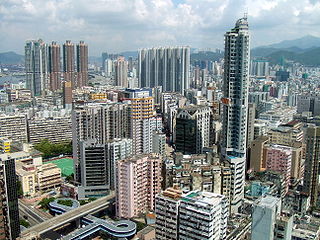
Kowloon is an urban area in Hong Kong comprising the Kowloon Peninsula and New Kowloon. It has a population of 2,019,533 and a population density of 43,033/km2 (111,450/sq mi) in 2006. It is one of the three regions of Hong Kong,along with Hong Kong Island and the New Territories,and is the smallest,second most populous and most densely populated.

Mong Kok is an area in Kowloon,Hong Kong. The Prince Edward subarea occupies the northern part of Mong Kok.

Yau Tsim Mong District is one of 18 districts of Hong Kong,located on the western part of Kowloon Peninsula. It is the core urban area of Kowloon. The district has the second highest population density of all districts,at 49,115 km2 (18,963 sq mi). The 2016 By-Census recorded the total population of Yau Tsim Mong District at 342,970.

Kwun Tong is an area in the Kwun Tong District of Hong Kong,situated at the eastern part of the Kowloon Peninsula,and its boundary stretches from Lion Rock in the north to Lei Yue Mun in the south,and from the winding paths of Kowloon Peak in the east to the north coast of the former Kai Tak Airport runway in the west.

The Tsuen Wan line is one of the ten lines of the metro network in Hong Kong's MTR. It is indicated in red on the MTR map.

Prince Edward is an area of Mong Kok south of Tong Mi surrounding Prince Edward station in Kowloon,Hong Kong. Named after Prince Edward Road West,the Prince Edward station of the MTR rapid transit system is an interchange station on the Tsuen Wan and the Kwun Tong lines.
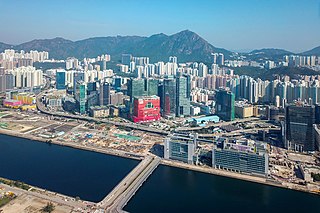
Kowloon Bay is a bay within Victoria Harbour and an neighbourhood within Kowloon,Hong Kong.

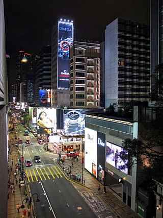
Nathan Road is the main thoroughfare in Kowloon,Hong Kong,aligned south–north from Tsim Sha Tsui to Sham Shui Po. It is lined with shops and restaurants and throngs with visitors,and was known in the post–World War II years as the Golden Mile,a name that is now rarely used. It starts on the southern part of Kowloon at its junction with Salisbury Road,a few metres north of Victoria Harbour,and ends at its intersection with Boundary Street in the north. Portions of the Kwun Tong and Tsuen Wan lines run underneath Nathan Road. The total length of Nathan Road is about 3.6 km (2.2 mi).
Tai Kok Tsui is an area west of Mong Kok in Yau Tsim Mong district in the Kowloon region of Hong Kong. The mixed land use of industrial and residential is present in the old area. The Cosmopolitan Dock and oil depots were previously located there. Blocks of high-rise residential buildings have been erected on the reclaimed area to the west,which marked the revitalisation of the area with many restaurants and bars setting up shop. Many of the older residential buildings have been vacated and are set to be replaced by high-rise residential and commercial buildings.

Argyle Street is a four-lane dual-way thoroughfare in Kowloon,Hong Kong,connecting the districts of Mong Kok,Ho Man Tin,Ma Tau Wai and Kowloon City. It runs on an east-west alignment starting at its intersection with Cherry Street,Ferry Street and Tong Mi Road in the west,and ending near the former Kai Tak Airport in the east. Due to the street's proximity with the latter,a variety of aircraft could be seen from this street and thus photographers seized the opportunity to capture landing aircraft.
Canton Road is a major road in Hong Kong,linking the former west reclamation shore in Tsim Sha Tsui,Jordan,Yau Ma Tei,Mong Kok and Prince Edward on the Kowloon Peninsula. The road runs mostly parallel and west to Nathan Road. It starts from the junction with Salisbury Road in the south and ends in the north at the junction with Lai Chi Kok Road in the Prince Edward area. The southern section of Canton Road is home to many upscale retail shops,shopping centres and others business establishments,with busy traffic from both vehicles and pedestrians from morning till late at night.

Kwun Tong Road is a major thoroughfare in Kwun Tong District,New Kowloon,Hong Kong.
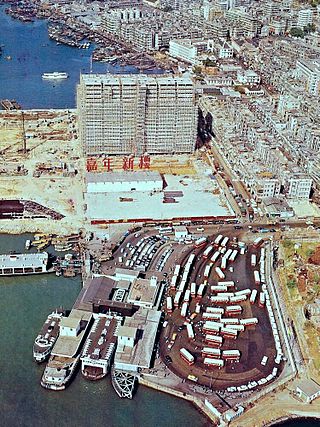
Jordan Road Ferry Pier or Ferry Point (1924–1998) is a demolished pier originally located at Jordan Road,Jordan,Hong Kong.
Articles related to Hong Kong include:
Kowloon is an urban area that is part of Hong Kong.

KMB Route 1A is a bus route operated by Kowloon Motor Bus (KMB) in Hong Kong. It runs between Star Ferry and Sau Mau Ping (Central) and provides air-conditioned service. The route runs via Tsim Sha Tsui,Yau Ma Tei,Mong Kok,Kowloon City,San Po Kong,Ngau Tau Kok,Kwun Tong,and Sau Mau Ping.
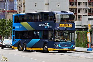
Kowloon Urban Route No. 20 is a Hong Kong bus route operated by Citybus,plying between Kai Tak and Cheung Sha Wan.


