Chatham Road

Last updated
Chatham Road
HK Chatham Road South 2009.jpg
Chatham Road South in May 2009
Native name漆咸道 (Yue Chinese)
Former name(s)Des Voeux Road
Part of Route 5
Namesake William Chatham
Location Kowloon, Hong Kong
Coordinates 22°18′14″N114°10′41″E / 22.30387°N 114.17796°E / 22.30387; 114.17796
Chatham Road (right) and parts of Kowloon c.1930 Chatham Road 1930.jpg
Chatham Road (right) and parts of Kowloon c.1930

Chatham Road South and Chatham Road North are two continuous roads extending from Tsim Sha Tsui to Hung Hom in Kowloon, Hong Kong. The road originally ran from Signal Hill to Hung Hom, under No. 12 Hill by the side of Hung Hom Bay. It was later extended through Lo Lung Hang to the southern end of To Kwa Wan, which makes up Chatham Road North.

Contents

Name

The first section of the road (running from Salisbury Road to Granville Road) was completed in 1888, and was named Des Voeux Road (德輔道) after Sir George William Des Vœux, the 10th Governor of Hong Kong. The road was renamed "Chatham Road" in 1890, after William Chatham, Director of Public Works of Hong Kong Government; the name Des Voeux Road was later[ when? ] transferred to a series of Des Voeux Road newly completed along the north shore of Hong Kong Island.

Chatham Road South

St. Mary's located in Chatham Road South in September 2006 HK TST St. Mary s Canossian College Jia Nuo Sa Sheng Ma Li Shu Yuan .jpg
St. Mary's located in Chatham Road South in September 2006

Chatham Road South (漆咸道南) runs from the intersection with Salisbury Road in Tsim Sha Tsui to the interchange with Hong Chong Road (康莊道) and Chatham Road North in Hung Hom. Conventionally locals take Chatham Road South as the dividing line between Tsim Sha Tsui and Tsim Sha Tsui East. Hong Kong Polytechnic University, Hong Kong Museum of History, Hong Kong Science Museum, Gun Club Hill Barracks and Rosary Church are located near the road.

Chatham Road North

Chatham Road North at night in February 2015 Chatham Road North at night (revised).jpg
Chatham Road North at night in February 2015

Chatham Road North (漆咸道北) runs from the interchange with Hong Chong Road and Chatham Road South in Lo Lung Hang to the junction with Ma Tau Wai Road near To Kwa Wan. It feeds into the East Kowloon Corridor at its northern end, forming a section of Hong Kong's Route 5.

See also

Related Research Articles

<span class="mw-page-title-main">Kowloon</span> Area of Hong Kong

Kowloon is an urban area in Hong Kong comprising the Kowloon Peninsula and New Kowloon. It has a population of 2,019,533 and a population density of 43,033/km2 (111,450/sq mi) in 2006. It is one of the three regions of Hong Kong, along with Hong Kong Island and the New Territories, and is the smallest, second most populous and most densely populated.

<span class="mw-page-title-main">Yau Tsim Mong District</span> District in Hong Kong, Kowloon

Yau Tsim Mong District is one of 18 districts of Hong Kong, located on the western part of Kowloon Peninsula. It is the core urban area of Kowloon. The district has the second highest population density of all districts, at 49,115 km2 (18,963 sq mi). The 2016 By-Census recorded the total population of Yau Tsim Mong District at 342,970.

<span class="mw-page-title-main">Tsim Sha Tsui</span> Urban area in Kowloon, Hong Kong

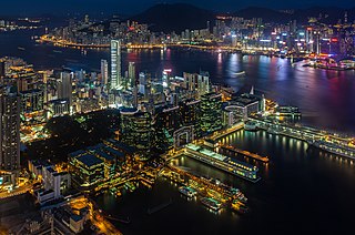
Tsim Sha Tsui, often abbreviated as TST, is an urban area in southern Kowloon, Hong Kong. The area is administratively part of the Yau Tsim Mong District. Tsim Sha Tsui East is a piece of land reclaimed from the Hung Hom Bay now east of Tsim Sha Tsui. The area is bounded north by Austin Road and in the east by Hong Chong Road and Cheong Wan Road.

Hong Kong counts approximately 600 temples, shrines and monasteries. While Buddhism and Christianity are the most widely practiced religions, most religions are represented in the Special Administrative Region.

<span class="mw-page-title-main">East Tsim Sha Tsui station</span> MTR interchange station in Kowloon, Hong Kong

East Tsim Sha Tsui is a station of the Mass Transit Railway (MTR) system of Hong Kong. It is currently an intermediate station on the Tuen Ma line.

<span class="mw-page-title-main">Nathan Road</span> Main street in Kowloon, Hong Kong

Nathan Road is the main thoroughfare in Kowloon, Hong Kong, aligned south–north from Tsim Sha Tsui to Sham Shui Po. It is lined with shops and restaurants and throngs with visitors, and was known in the post–World War II years as the Golden Mile, a name that is now rarely used. It starts on the southern part of Kowloon at its junction with Salisbury Road, a few metres north of Victoria Harbour, and ends at its intersection with Boundary Street in the north. Portions of the Kwun Tong and Tsuen Wan lines run underneath Nathan Road. The total length of Nathan Road is about 3.6 km (2.2 mi).

<span class="mw-page-title-main">Hung Hom station</span> Railway station in Kowloon, Hong Kong

Hung Hom is a passenger railway station in Hung Hom, Kowloon, Hong Kong. It is an interchange station between the East Rail line and the Tuen Ma line domestic services of the MTR network, as well as the southern terminus of cross-border through-trains to mainland China which has been suspended since 4 February 2020. The station is one of four Hong Kong ports of entry on the MTR network; the others are Lo Wu, Lok Ma Chau, and West Kowloon. This station serves the southern terminus of the East Rail Line in early morning before the first northbound train from Admiralty arrives. As the station is located next to the Cross-Harbour Tunnel's northern portal, it is also served by many cross-harbour bus routes.

<span class="mw-page-title-main">Salisbury Road, Hong Kong</span> Road in Tsim Sha Tsui, Hong Kong

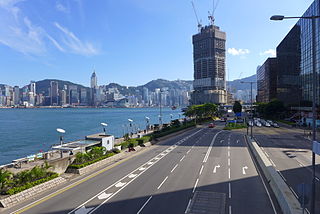
Salisbury Road is a major road in Tsim Sha Tsui, Kowloon, Hong Kong.

<span class="mw-page-title-main">Wan Chai Pier</span> Pier in Hong Kong

The Wan Chai Pier, or Wan Chai Ferry Pier, is a pier at the coast of Wan Chai North on the Hong Kong Island of Hong Kong. The pier is operated by Star Ferry, and provides ferry services to Tsim Sha Tsui. The pier is near the Hong Kong Convention and Exhibition Centre.

<span class="mw-page-title-main">Middle Road, Hong Kong</span> Street in Tsim Sha Tsui, Hong Kong

Middle Road is a street in the southern part of Tsim Sha Tsui, Kowloon, Hong Kong.

East Kowloon line was one of the original five MTR lines proposed in the late 1970s in Hong Kong, which would have connected Sheung Wan with East Kowloon.

<span class="mw-page-title-main">Jordan Road Ferry Pier</span> Demolished pier originally located at Jordan Road, Jordan, Hong Kong

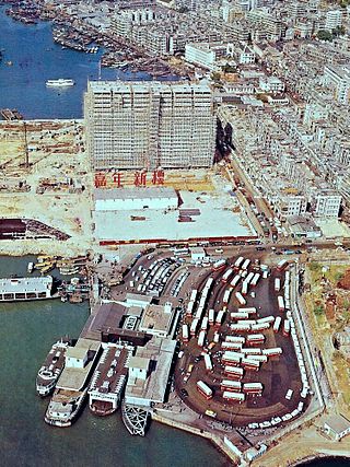
Jordan Road Ferry Pier or Ferry Point (1924–1998) is a demolished pier originally located at Jordan Road, Jordan, Hong Kong.

Articles related to Hong Kong include:

<span class="mw-page-title-main">Hung Hom Ferry Pier</span> Ferry pier in Kowloon, Hong Kong

Hung Hom Ferry Pier is a ferry pier in Hung Hom, Kowloon, Hong Kong. It is at the reclaimed Hung Hom Bay at the south of Lily Mansion, Whampoa Garden.

<span class="mw-page-title-main">Mountain Shore</span> Private housing estate in Hong Kong

Mountain Shore is a full market value development in Tai Shui Hang, Ma On Shan, Sha Tin District, New Territories, Hong Kong. The estate is one of the Hong Kong Housing Society's Sandwich Class Housing Scheme projects converted into private developments.

References

Commons-logo.svg Media related to Chatham Road at Wikimedia Commons

Preceded by
East Kowloon Corridor
Hong Kong Route 5
HK Route5.svg
Chatham Road
Succeeded by
West Kowloon Corridor