Kowloon is an urban area in Hong Kong comprising the Kowloon Peninsula and New Kowloon. It has a population of 2,019,533 and a population density of 43,033/km2 (111,450/sq mi) in 2006. It is one of the three regions of Hong Kong,along with Hong Kong Island and the New Territories,and is the smallest,second most populous and most densely populated.

The Tsuen Wan line is one of the ten lines of the metro network in Hong Kong's MTR. It is indicated in red on the MTR map.

Mei Foo is a Hong Kong MTR station located in Mei Foo Sun Chuen,Lai Chi Kok,New Kowloon. It is the only interchange station between the Tsuen Wan line and the Tuen Ma line,situated between Lai Chi Kok and Lai King stations on the Tsuen Wan line and Nam Cheong and Tsuen Wan West stations on the Tuen Ma line. Mei Foo station's colour is blue.

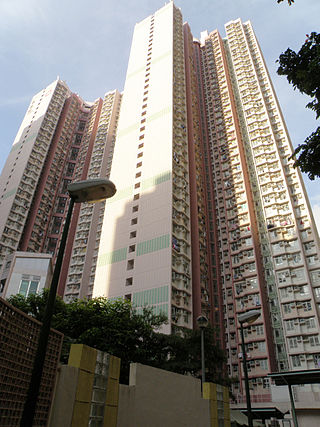
Mei Foo Sun Chuen or simply Mei Foo is a large private housing estate in Lai Chi Kok,Kowloon,Hong Kong. Mei Foo Sun Chuen was the first large scale private housing estate in Hong Kong and at the time of completion,the 99-tower complex was considered the largest private housing development in the world,accommodating some 70,000 –80,000 people in 13,500 apartments. It is considered to be one of the world's largest privately financed residential condominium projects.

Sham Shui Po District is one of 18 districts of Hong Kong. It is the second poorest district by income in Hong Kong,with a predominantly working-class population of 405,869 in 2016 and the lowest median household income of all districts. Sham Shui Po has long been home to poorer new immigrants from China. It also saw the birth of public housing in Hong Kong,as the government sought to resettle those displaced by a devastating fire in its slums. Sham Shui Po also hosted a Vietnamese refugee camp during the influx of migration in the aftermath of the Vietnam War in the 1970s.

Lai Chi Kok is a neighbourhood in Kowloon,Hong Kong,east of Kwai Chung and west of Cheung Sha Wan. Mei Foo Sun Chuen is the largest housing estate in the area and also the largest in Hong Kong with 99 blocks. Administratively,it belongs to Sham Shui Po District.

West Kowloon Corridor is part of Route 5 in Hong Kong. Bypassing existing surface roads in West Kowloon,it connects Lai Chi Kok Road in Cheung Sha Wan with the Gascoigne Road Flyover near Yau Ma Tei.

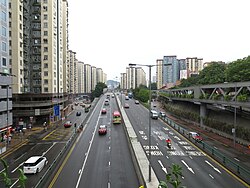
Lai Chi Kok Road is a road in western Kowloon,Hong Kong. It links Lai Chi Kok to Mong Kok,via Tai Kok Tsui,Sham Shui Po and Cheung Sha Wan. It starts from a junction with Nathan Road near Pioneer Centre in the south and ends near Mei Foo Sun Chuen. The road is bidirectional except the section at Lai Chi Kok,between the junction with Butterfly Valley Road and Mei Foo Sun Chuen,where it serves New Territories-bound traffic only. The Kowloon-bound traffic uses Cheung Sha Wan Road,separated by the flyover of Kwai Chung Road. The road once hosted shipyards,fish,meat and vegetable wholesale markets,which were moved closer to the coast after extensive reclamation.

Kwai Chung Road is a throughway in Kwai Chung of the New Territories in Hong Kong. It is one of the busiest roads in Hong Kong. The Transport Department has classified it as a trunk road.

Route 5 is a strategic route in Hong Kong from eastern to western Kowloon and New Kowloon,and ends in Tsuen Wan in the New Territories where it connects to Route 9. It is one of the most seriously congested routes in Kowloon,as it serves as an interchange to the Hung Hom Cross-Harbour Tunnel,especially during peak hours.

The Hong Kong Strategic Route and Exit Number System is a system adopted by the Transport Department of the Hong Kong Government to organise the major roads in the territory into routes 1 to 10 for the convenience of drivers. When the system was implemented in 2004,the government promoted it with a major public campaign,including the slogan "Remember the Numbers;Make Driving Easier".
Wah Lai Estate is a public housing estate in Lai Chi Kok,Kowloon,Hong Kong. It consists of a total of two residential blocks completed in 2001.

The following is an overview of Public housing estates in Kwai Chung,Hong Kong,including Home Ownership Scheme (HOS),Private Sector Participation Scheme (PSPS),Sandwich Class Housing Scheme (SCHS),Flat-for-Sale Scheme (FFSS),and Tenants Purchase Scheme (TPS) estates.

Nob Hill is a private housing estate in Lai Chi Kok,Kowloon,Hong Kong,located at the former site of Lai Chi Kok Amusement Park,together with Wah Lai Estate and Lai Yan Court. It has three residential blocks and a shopping centre. It was jointly developed by Cheung Kong Holdings and Far East Hotels and Entertainment in 2002.
Mei Foo Ferry Pier was a ferry pier in Mei Foo Sun Chuen,Lai Chi Kok,Kowloon,Hong Kong,located outside Block 6 of the estate.
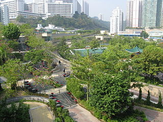
Lai Chi Kok Park is a large public park in Hong Kong,on the reclamation of former Lai Chi Kok Bay adjacent to Mei Foo,stretching along the Kwai Chung Road motorway. The park is managed by the Leisure and Cultural Services Department of the Hong Kong Government.