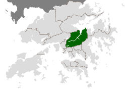
Sha Tin District

Last updated

Sha Tin
沙田區
Shatin
Sha Tin District
HK AmahRock Shatin.JPG
Day view of the Sha Tin District skyline
Sha Tin District
Hong Kong Sha Tin District.svg
Location of Sha Tin District within Hong Kong
Coordinates: 22°23′14″N114°11′43″E / 22.38715°N 114.19534°E / 22.38715; 114.19534
Region New Territories
District Council Constituencies 41
Government
   District Council Chairman Mak Yun-Pui,Chris
   District Council Vice-Chairman Sin Cheuk-Nam
Area
  Total69.27 km2 (26.75 sq mi)
  Land69.27 km2 (26.75 sq mi)
  Lands Department [1]
Population
 (2021)
  Total692,806 [2]
  Density10,082/km2 (26,110/sq mi)
  Census and Statistics Department [2]
Time zone UTC+8 (Hong Kong Time)
Website districtcouncils.gov.hk

History

Pre-colonial Era

According to archeological discoveries, there were inhabitants settled in the region around four thousand years ago. Sha Tin was formerly named Lek Yuen, literally meaning the "source of trickling" or "source of clear water". The area of the present day Sha Tin was populated before the Ming Dynasty. As the Shing Mun River runs across the district, most local residents were farmers and relied on agriculture for living. In 1579, Tai Wai Village, the oldest and largest walled village in the district was built. Several other villages were built along the river after Tai Wai Village.

Colonial Era

Sha Tin started to be administered by the British Hong Kong government after the Convention for the Extension of Hong Kong Territory was signed. The establishment of the Sha Tin station of the Kowloon-Canton Railway (British Section) in 1910 caused Sha Tin to be the more common name for the area, replacing Lek Yuen ever since.

Sha Tin was a former market town at the present location of Sha Tin Centre Street and New Town Plaza shopping centre.

Sha Tin Town was the second batch of satellite towns, or new towns, to be built in the New Territories, on land reclaimed from the sea.

Land use

Sha Tin and Shing Mun River Sha Tin Shing Mun River.JPG
Sha Tin and Shing Mun River
Wu Kai Sha Wu Kai Sha Beach 201108.jpg
Wu Kai Sha

In addition to the residential areas, there are four industrial areas for light industries: Tai Wai, Fo Tan, Siu Lek Yuen and Shek Mun.

The Chinese University of Hong Kong is also located in Sha Tin. People typically travel there via the MTR East Rail line and get off at University station. A minibus service operates on campus.

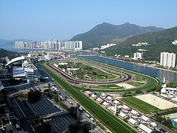
Sha Tin is the location for Hong Kong's second equestrian racecourse (the first and most famous being Happy Valley Racecourse) which has a capacity of 85,000. This course hosted the equestrian events during the 2008 Summer Olympics. The Olympics were hosted by Beijing, but there was concern over proper quarantine and disease monitoring in the Chinese capital.

Penfold Park is located inside the racecourse and closed on race days. It is best accessed via the Fo Tan station. Sha Tin Park is another major park located in Sha Tin.

Shing Mun River

Residential, commercial and industrial buildings with numerous village type developments has been built along the two sides of the Shing Mun River since the early stage of development of Shatin. ShaTin-ShingMunRiver-EarlyStageOfDevelopment.jpg
Residential, commercial and industrial buildings with numerous village type developments has been built along the two sides of the Shing Mun River since the early stage of development of Shatin.
Tim Sam Street in Tai Wai Tim Sam Street 2011.jpg
Tim Sam Street in Tai Wai

The Shing Mun River is a 7 km long, 200m wide channel originating at the Shing Mun Reservoir (Tai Mo Shan catchment) that runs as a river from the Tai Wai area, through the Sha Tin town centre to Tide Cove. It has three main tributaries, namely Tai Wai Nullah, Fo Tan Nullah and Siu Lek Yuen Nullah. Along the Shing Mun River are high-rise residential, commercial and industrial buildings with numerous village type developments scattered around.

Transportation

Sha Tin District
Traditional Chinese 沙田區
Simplified Chinese 沙田区
Jyutping Saa1 tin4 keoi1
Literal meaning"sand field district"

Railways

Sha Tin District is served by a total of fourteen rapid transit stations on two lines of the MTR railway network, the most of any district in Hong Kong. Five of these stations lie on the East Rail line, namely Tai Wai, Sha Tin, Fo Tan, Racecourse and University. Although all except Racecourse station (which only has service on race days) lie on the original Kowloon–Canton Railway, the oldest in the territory, only Sha Tin station existed at the time the line was inaugurated in 1910, providing direct service to Hung Hom station in Kowloon in the south and the mainland border crossings at Lo Wu and Lok Ma Chau in the north. The other four stations were added later, mostly during the electrification of the line in the 1980s, as a result of the development of the Chinese University, Sha Tin Racecourse, and Sha Tin New Town.

The Ma On Shan line, a branch of the East Rail line, began service in December 2004, serving the eastern parts of Sha Tin and the Ma On Shan area. Its nine stations, running between Tai Wai and Wu Kai Sha, were all located within Sha Tin District, and served newly built housing estates along the route. The only interchange between this line and the rest of the network was at Tai Wai, leading to extreme congestion on the East Rail line between this station and Kowloon Tong, which has a connection to the Kwun Tong line. Both this line and the East Rail line were operated by the Kowloon-Canton Railway Corporation until they were absorbed by the MTR Corporation in 2007.

Railway connectivity to and from Sha Tin District is expected to be significantly improved following the completion of the Sha Tin to Central Link, which will see extensions to both the East Rail and Ma On Shan lines. The first section, known as Tuen Ma line Phase 1, opened in January 2020, extending the Ma On Shan line to Kai Tak via Diamond Hill, and includes a further station serving Hin Keng at the southern end of Sha Tin District. This is expected to relieve congestion on the East Rail line between Tai Wai and Kowloon Tong. By the end of 2021, the full Tuen Ma line would open with a new route through Kowloon City, merging with the West Rail line at Hung Hom and continuing to the northwestern New Territories via western Kowloon. Finally, in 2022, the East Rail line would be extended across Victoria Harbour and terminate at Admiralty station, providing a direct service to Hong Kong Island for the first time.

Buses

A total of 110 franchised bus routes serve various points in Sha Tin District. These are predominantly operated by Kowloon Motor Bus, which has a depot in Siu Lek Yuen. They include a combination of routes entirely within the district, routes connecting the district to other parts of the New Territories and Kowloon, and several cross-harbour routes to Hong Kong Island, including one as far as Aberdeen. Furthermore, Long Win Bus operates several routes to Lantau Island, the airport, and the Hong Kong–Zhuhai–Macau Bridge, while New World First Bus has express bus service to eastern Hong Kong Island and Tseung Kwan O.

The district is also served by various public light bus routes.

Roads

Sha Tin District is served by an extensive road network. Four trunk routes on Hong Kong's strategic route network pass through the district:

These trunk roads make use of several road tunnels leading to the district. Of these, the Lion Rock Tunnel used by Route 1, is the oldest, having opened in 1967 to replace the overcrowded Tai Po Road to Sham Shui Po. Despite the opening of further tunnels over the years, it remains the most direct route to central Kowloon, and thus the most heavily travelled. The Lion Rock Tunnel was followed by the Shing Mun Tunnels on Route 9 in 1990, the Tate's Cairn Tunnel on Route 2 in 1991, and most recently the Tsing Sha Highway on Route 8 (consisting of the Eagle's Nest Tunnel and Sha Tin Heights Tunnel) in 2008.

Other major roads in the area include Sha Lek Highway linking central Sha Tin to Ma On Shan, Sha Tin Road linking eastern Sha Tin to Fo Tan, Tate's Cairn Highway linking eastern Sha Tin to Ma Liu Shui, Tolo Highway linking Sha Tin to the northern districts, and Sai Sha Road linking Ma On Shan to Sai Kung.

A network of cycle tracks throughout Sha Tin measures about 50 km long and is the longest cycle track network in Hong Kong.

Education

Secondary schools

Schools with Wikipedia articles:

Higher education

Hospitals

There are four hospitals in Sha Tin District:

Cityscape

The view looking south from Shatin Lion Pavilion HK Shatin New Town Panorama 201008.jpg
The view looking south from Shatin Lion Pavilion

Tourist attractions

Tsang Tai Uk: external view Tsang Tai Uk Ceng Da Wu o.jpg
Tsang Tai Uk: external view
Sha Tin Racecourse Sha Tin Racecourse Overview 2009.jpg
Sha Tin Racecourse
Tao Fong Shan Tao Fung Shan 01.jpg
Tao Fong Shan

Local and tourist attractions in the Sha Tin area include, most famously, the Hong Kong Heritage Museum, which is Hong Kong's largest museum. The Museum was opened on 16 December 2000 and includes 12 galleries, a café and museum shop. Other attractions include:

See also

Related Research Articles

<span class="mw-page-title-main">Shing Mun River</span> River in Sha Tin, Hong Kong

The Shing Mun River or Shing Mun River Channel is a river in Sha Tin, Hong Kong.

Hong Kong counts approximately 600 temples, shrines and monasteries. While Buddhism and Christianity are the most widely practiced religions, most religions are represented in the Special Administrative Region.

<span class="mw-page-title-main">Tai Wai</span> Area in the New Territories, Hong Kong

Tai Wai is an area in the New Territories, Hong Kong, located between Sha Tin and the Lion Rock, within the Sha Tin District.

<span class="mw-page-title-main">Che Kung Temple station</span> MTR station in the New Territories, Hong Kong

Che Kung Temple is a station on Hong Kong's Tuen Ma line. It is located on Che Kung Miu Road in Sha Tin in the New Territories. Its position was Sha Tin Tau Temporary Housing Area, so it was provisionally called "Sha Tin Tau" before the Ma On Shan line opened.

<span class="mw-page-title-main">Telephone numbers in Hong Kong</span>

Telephone numbers in Hong Kong are mostly eight-digit. Fixed land line numbers start with 2 or 3, mobile (cellular) phone numbers with 5, 6, 7 or 9, pager numbers with 7 and forwarding service with 8. Since the end of 1989, there have been no area codes within Hong Kong.

<span class="mw-page-title-main">City One</span> Housing estate in Sha Tin, New Territories

City One Shatin is a residential precinct in Sha Tin, New Territories, Hong Kong. The estate occupies approximately 1,800,000 square feet of land. The estate was named City One as it is on Lot 1, Shatin Town. It has a census area population of 24,758 people. City One is the largest private residential estate in Sha Tin District. There are a total of 52 blocks of residential buildings with 10,642 units. Each tower is about 30 storeys with units ranging from 389 square feet (36.1 m2) to an area of 1,018 square feet (94.6 m2), offering different floor plans.

<span class="mw-page-title-main">Route 1 (Hong Kong)</span> Major road in Hong Kong

Route 1 is a major artery in Hong Kong that runs in a generally north-south direction, connecting Aberdeen with Sha Tin.

<span class="mw-page-title-main">Sha Tin</span> Neighbourhood in New Territories, Hong Kong, China

Sha Tin, also spelt Shatin, is a neighbourhood along Shing Mun River in the eastern New Territories, Hong Kong. Administratively, it is part of the Sha Tin District. Sha Tin is one of the neighbourhoods of the Sha Tin New Town project.

<span class="mw-page-title-main">Sha Tin New Town</span> Satellite Town in Hong Kong, China

Sha Tin New Town, or known as Sha Tin-Ma On Shan New Town or Sha Tin Town is one of the satellite towns and new towns of Hong Kong. It is within the Sha Tin District, the New Territories. The New Town covers the neighbourhoods such as Sha Tin, Tai Wai, Fo Tan, Tai Shui Hang, Ma On Shan. The Shing Mun River runs through the middle of the town.

East Kowloon line was one of the original five MTR lines proposed in the late 1970s in Hong Kong, which would have connected Sheung Wan with East Kowloon.

<span class="mw-page-title-main">Yuen Long Town</span> Human settlement in New Territories, Hong Kong

Yuen Long Town is located in the district centre of Yuen Long District, New Territories, Hong Kong. It is the heart of Yuen Long and Yuen Long New Town, with a population of around 200,000.

Articles related to Hong Kong include:

<span class="mw-page-title-main">Tuen Ma line</span> Hong Kong MTR railway line

The Tuen Ma lineis a rapid transit line that forms part of the Mass Transit Railway (MTR) system in Hong Kong. Coloured brown on the map, the Tuen Ma line is 56.2 kilometres (34.9 mi) in length, making it the longest line of the MTR network. It has a total of 27 stations, more than any other in the MTR system.

The following is a non-exhaustive list of private housing estates in Sha Tin District, Hong Kong.

<span class="mw-page-title-main">Public housing estates in Sha Tin</span>

The following is a list of public housing estates in Sha Tin, Hong Kong, including Home Ownership Scheme (HOS), Private Sector Participation Scheme (PSPS), Sandwich Class Housing Scheme (SCHS), Flat-for-Sale Scheme (FFSS), and Tenants Purchase Scheme (TPS) estates.

<span class="mw-page-title-main">New towns of Hong Kong</span> Newly developed towns in the 20th century

The Hong Kong government started developing new towns in the 1950s to accommodate Hong Kong's booming population. During the first phase of development, the newly developed towns were called "satellite towns", a concept borrowed from the United Kingdom, of which Hong Kong was a colony. Kwun Tong, located in eastern Kowloon, and Tsuen Wan, located in the south-west of the New Territories, were designated as the first satellite towns, when the urban area in Hong Kong was still relatively small, restricted to the central and western parts of Kowloon Peninsula and the northern side of Hong Kong Island. Wah Fu Estate was also built in a remote corner on the southern side of Hong Kong Island, with similar concepts but at a smaller scale.

References

  1. "Hong Kong Geographic Data (As at October 2021)". Lands Department, Hong Kong SAR . January 2022. Retrieved 4 August 2022.
  2. 1 2 2021 Population Census: Summary Results (PDF). Census and Statistics Department, Hong Kong SAR (Report). February 2022.
  3. 2016 Population By-census Summary Results (PDF), Hong Kong: Census and Statistics Department, 2017, p. 19, retrieved 9 February 2020
  4. "District Highlights". Sha Tin District Council. April 2012. Archived from the original on 10 March 2014. Retrieved 11 June 2012.
  5. Lill, Coran (2 July 2004). "TTP to build Asian towers". ShareChat.co.nz. Retrieved 11 June 2012.