This article has multiple issues. Please help improve it or discuss these issues on the talk page . (Learn how and when to remove these template messages)
|
Yau Yat Tsuen 又一村 | |
|---|---|
Area | |
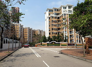
 Tat Chee Avenue, the main road in Yau Yat Tsuen | |
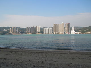
 Yau Yat Tsuen | |
| Coordinates: 22°19′51″N114°10′26″E / 22.33083°N 114.17389°E | |
| Country | Hong Kong |
| Region | Kowloon |
| District | Sham Shui Po |
| Founded by | Yu Tat Chi[ clarification needed ] |
| Government | |
| • Type | District Council |
| • Councillor | Dominic Lee Tsz-king (Liberal) |
| Population (2015) | |
| • Total | 16,484 |
| Time zone | UTC+08:00 (HKT) |
Naming
The area's name comes from a poem by Southern Song era poet Lu You, titled Touring Shanxi Village. [2] The name comes from the fourth verse in the poem (柳暗花明又一村; liǔ àn huā míng yòu yī cūn), which translates to Then out of the shade of the willows, came bright flowers and another village. Hence, the area's name literally translates to "another village".
Facilities
As a primarily residential area, there are relatively few services inside Yau Yat Tsuen. There is a small supermarket, a few property agents, a post office and a few other local stores. However a large shopping centre, Festival Walk, is on the edge of the village. It consists of 200 stores including a cinema and an ice-skating rink. The whole area of Yau Yat Tsuen is also within walking distance from the Kwun Tong line (Shek Kip Mei and Kowloon Tong) and East Rail line (Kowloon Tong) of MTR, the only mass transit railway operator of Hong Kong.
History
After the Second World War, affluent families built large detached houses in the area of Yau Yat Tsuen. Since then, it has been expanded and covers a much larger area. Along with the neighbouring Kowloon Tong and Beacon Hill, the area has some of the most exclusive and expensive residential properties in Kowloon.
Development
1970s
In the 1970s, some of the large houses were subdivided into approximately ten flats in each block. However, with high property prices in Hong Kong, these 3 or 4 bedroom flats, which tend to cost more than 7 million Hong Kong dollars, are still prohibitively expensive for a large section of the Hong Kong population.
1980s
In the 1980s, the large development scheme of Village Garden was constructed and more 1,000 to 2,400 square feet (93 to 223 m2) flats and houses were built.
1990s
In the early 1990s Yau Yat Tsuen continued to expand with the development of Parc Oasis, where more than twenty 10-storey blocks were developed. In 1992 the nearby Polytechnic gained University status and became the City University of Hong Kong.
Education
Yau Yat Tsuen is in Primary One Admission (POA) School Net 40. Within the school net are multiple aided schools (operated independently but funded with government money) and two government schools: Fuk Wing Street Government Primary School and Li Cheng Uk Government Primary School. [3]
Related Research Articles

Kowloon is an urban area in Hong Kong comprising the Kowloon Peninsula and New Kowloon. It has a population of 2,019,533 and a population density of 43,033/km2 (111,450/sq mi) in 2006. It is one of the three regions of Hong Kong, along with Hong Kong Island and the New Territories, and is the smallest, second most populous and most densely populated.

Sham Shui Po is an area of Kowloon, Hong Kong, situated in the northwestern part of the Kowloon Peninsula, north of Tai Kok Tsui, east of Cheung Sha Wan and south of Shek Kip Mei (石硤尾). It is located in and is the namesake of the Sham Shui Po District.

Yau Ma Tei is an area in the Yau Tsim Mong District in the south of the Kowloon Peninsula in Hong Kong.

Kowloon Tong (Chinese: 九龍塘) is an area of Hong Kong located in Kowloon. The majority of the area is in the Kowloon City District. Its exact location is south of the Lion Rock, north of Boundary Street, east of the East Rail line and west of Grampian Road. It is one of the most expensive residential districts in Hong Kong.

Sheung Shui is an area in the New Territories, Hong Kong. Sheung Shui Town, a part of this area, is part of the Fanling–Sheung Shui New Town in the North District of Hong Kong. Fanling Town is to its southeast.

Fanling is a town in the New Territories East of Hong Kong. Administratively, it is part of the North District. Fanling Town is the main settlement of the Fanling area. The name Fanling is a shortened form of Fan Pik Leng (粉壁嶺). The area has several public and private estates.

Lei Yue Mun is a short channel in Hong Kong. It lies between Junk Bay and Victoria Harbour, separating Kowloon and Hong Kong Island. The channel is an important passage for the city, forming the eastern entrance of Victoria Harbour.
Castle Peak Road is the longest road in Hong Kong. Completed in 1920, it runs in the approximate shape of an arc of a semi-circle. It runs West from Tai Po Road in Sham Shui Po, New Kowloon, to Tuen Mun, then north to Yuen Long then east to Sheung Shui, in the very north of the New Territories. It is divided into 22 sections. It serves south, west and north New Territories, being one of the most distant roads in early Hong Kong.
Sham Shui Po District is one of 18 districts of Hong Kong. It is the second poorest district by income in Hong Kong, with a predominantly working-class population of 405,869 in 2016 and the lowest median household income of all districts. Sham Shui Po has long been home to poorer new immigrants from China. It also saw the birth of public housing in Hong Kong, as the government sought to resettle those displaced by a devastating fire in its slums. Sham Shui Po also hosted a Vietnamese refugee camp during the influx of migration in the aftermath of the Vietnam War in the 1970s.

Lai Chi Kok is a neighbourhood in Kowloon, Hong Kong, east of Kwai Chung and west of Cheung Sha Wan. Mei Foo Sun Chuen is the largest housing estate in the area and also the largest in Hong Kong with 99 blocks. Administratively, it belongs to Sham Shui Po District.

Lai Chi Kok Road is a road in western Kowloon, Hong Kong. It links Lai Chi Kok to Mong Kok, via Tai Kok Tsui, Sham Shui Po and Cheung Sha Wan. It starts from a junction with Nathan Road near Pioneer Centre in the south and ends near Mei Foo Sun Chuen. The road is bidirectional except the section at Lai Chi Kok, between the junction with Butterfly Valley Road and Mei Foo Sun Chuen, where it serves New Territories-bound traffic only. The Kowloon-bound traffic uses Cheung Sha Wan Road, separated by the flyover of Kwai Chung Road. The road once hosted shipyards, fish, meat and vegetable wholesale markets, which were moved closer to the coast after extensive reclamation.
Sham Tseng is a coastal area in Tsuen Wan District, Hong Kong, between Ting Kau and Tsing Lung Tau.

Shap Pat Heung is an area in the New Territories of Hong Kong. Located south of Yuen Long and northeast of Tai Tong, the area occupies the plain north of hills of Tai Lam. The Cantonese name 'Shap Pat Heung' means 'eighteen villages' at its beginning. It was later expanded to thirty villages. Administratively, it is part of the Yuen Long District.
Public housing estates in Shek Kip Mei are public housing in an area originally known as Kap Shek Mi in New Kowloon on the North Eastern Kowloon Peninsula of Hong Kong.
The 2013–14 Hong Kong Third Division League is the 63rd season of Hong Kong Third Division League, the third-tier football league in Hong Kong organised by the Hong Kong Football Association.
Parc Oasis is a private housing estate in Yau Yat Chuen, Kowloon, Hong Kong, located near MTR Kowloon Tong station. It is one of the largest development in Yau Yat Chuen. After the completion of the Festival Walk in 1998, shopping, watching movies and dining were more convenient. Nearby area in Kowloon Tong is a place of many famous kindergartens, primary and secondary schools.

Yau Yat Tsuen is one of the 25 constituencies in the Sham Shui Po District of Hong Kong.
References
- ↑ "District Council Constituency Boundaries - Sham Shui Po District" (PDF). Hong Kong: Electoral Affairs Commission. January 2015. Retrieved 5 April 2019.
- ↑ Lam, Wing Kin (12 May 2017). "【恒管清思】錯譯香港街名 泉水誤作春園" [Pure Thoughts from HSMC: Wrongfully translate Hong Kong's street name, "Spring Water" turns into "Spring Garden"]. Wen Wei Po (in Chinese). Retrieved 9 January 2019.
不少香港街道的取名卻饒有深意,甚或帶有相當中國文化色彩。如九龍塘著名住宅區「又一村」,其名稱固然是取自南宋詩人陸游名句「柳暗花明又一村」。(Many names for Hong Kong streets have rather deep meaning, and can even have Chinese cultural characteristics. For example, the famous Kowloon Tong residential area"Yau Yat Chuen", its name obviously came from Southern Song poet Lu You's famous phrase, "Then out of the shade of the willows, came bright flowers and another village.")
- ↑ "POA School Net 40" (PDF). Education Bureau . Retrieved 2022-09-12.
| Yau Yat Tsuen | |||||||||||
|---|---|---|---|---|---|---|---|---|---|---|---|
| Traditional Chinese | 又一村 | ||||||||||
| |||||||||||
Urban areas of Hong Kong, Kowloon and New Territories | ||
|---|---|---|
| Hong Kong 1,3,4,5,6,7,8 |  | |
| Kowloon KL,1,2,3,4,5,6,7,8 | ||
| New Kowloon NKL,2,3,4,5,6,7,8 | ||
| New Territories | ||
Official place names are from "Hong Kong Guide" of Lands Department and "Hong Kong Guide Book" of Universal Publications Ltd. KL: Kowloon Peninsula at the south of Boundary Street NKL: Former New Territories area at the north of Boundary Street and at the south of Lion Rock 1: Common definition (1) 2: Common definition (2) 3: Common definition (3) 4: Areas not adopting small house concessionary right of indigenous inhabitants 5: Jurisdiction area of former Urban Council 6: Definition of "Metropolitan Area" of Planning Department 7: Jurisdiction area of Urban Renewal Authority 8: Unique operating area of urban taxis | ||