青衣 | |
|---|---|
 Tsing Yi, viewed from Shek Lung Kung | |
 Tsing Yi Location within Hong Kong | |
| Geography | |
| Location | Central New Territories |
| Area | 10.69 km2 (4.13 sq mi) |
| Length | 5.2 km (3.23 mi) |
| Width | 4.5 km (2.8 mi) |
| Highest elevation | 334 m (1096 ft) |
| Highest point | Tsing Yi Peak (Sam Chi Heung) |
| Administration | |
| Districts | Kwai Tsing District |
| Demographics | |
| Population | 191,500 |
- Tsing Yi Bamboo Theatre
- List of islands and peninsulas of Hong Kong
- Kam Chuk Kok
- List of places in Hong Kong
- Tsing Yi Rural Committee
- My Home Purchase Plan
Related Research Articles

Kwai Tsing is one of the 18 districts of Hong Kong. It consists of two parts - Kwai Chung and Tsing Yi Island. Kwai Tsing is part of the New Territories. It had a population of 520,572 in 2016. The district has the third least educated residents and their income is below average.

Tsuen Wan New Town is a new town in Hong Kong. It spans Tsuen Wan, Kwai Chung and the eastern part of Tsing Yi Island. Traditionally, the administrative officials of Tsuen Wan managed the area of Tsuen Wan proper, Kwai Chung, Tsing Yi Island, Ma Wan and Northeast Lantau Island. Its total development area is about 24 square kilometres (9.3 sq mi). The population of the new town is approximately 801,800, with the planned capacity being 845,000.
Hong Kong counts approximately 600 temples, shrines and monasteries. While Buddhism and Christianity are the most widely practiced religions, most religions are represented in the Special Administrative Region.

Rambler Channel is a body of water in Hong Kong that separates Tsing Yi Island from Tsuen Wan and Kwai Chung in the New Territories. The channel separates the two landmasses by 900 metres at its widest point.

Tsing Yi South Bridge, opened as the Tsing Yi Bridge on 28 February 1974, was the first bridge to Tsing Yi, Hong Kong. It spans the Rambler Channel, linking Tsing Yi Island to the former Pillar Island, Kwai Chung. The bridge spans 610 metres and is 26 metres (85 feet) high. It contributed significantly to the development of Tsing Yi, particularly in the 1970s and 1980s. It is the only bridge across the channel which may be used by cycles and so is the only route connecting Tsing Yi and the Tsuen Wan/Kwai Chung area for cyclists. The name "Tsing Yi South Bridge" was adopted following the 1987 opening of the second bridge to Tsing Yi, the Tsing Yi North Bridge.
Mun Tsai Tong or Moon Tsai Tong was a harbour located between northeast Tsing Yi Island and Nga Ying Chau in Hong Kong. It was reclaimed for the development of a new town on Tsing Yi Island in 1980s. The harbour became two public housing estates, Cheung On Estate and Cheung Fat Estate.

Tsuen Wan is a town built on a bay in the western New Territories of Hong Kong, opposite of Tsing Yi Island across Rambler Channel. The market town of Tsuen Wan emerged from the surrounding villages and fleets of fishing boats in the area. The modern city is centered the Tsuen Wan station of the MTR. Its coastline was further extended through land reclamation.
Tsuen Wan Rural Committee (荃灣鄉事委員會) is a rural committee representing the interest of villages in Tsuen Wan and Kwai Chung, Hong Kong.

Kwai Chung Road is a throughway in Kwai Chung of the New Territories in Hong Kong. It is one of the busiest roads in Hong Kong. The Transport Department has classified it as a trunk road.

Tsing Yi Peak, also known as Sam Chi Heung, is a hill with three peaks occupying the southern half of the Tsing Yi Island, Hong Kong. The hill is situated on the western half of Victoria Harbour. Its peaks are good locations to observe the harbour and the channels among harbour islands. While situated in the south, a short hill Liu To Shan occupies the northwest of the island.
Articles related to Hong Kong include:
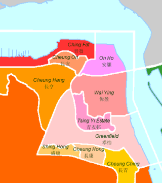
The following is an overview of public housing estates on Tsing Yi, Hong Kong including Home Ownership Scheme (HOS), Private Sector Participation Scheme (PSPS), Flat-for-Sale Scheme (FFSS), Tenant Purchase Scheme (TPS) and Subsidised Sale Flats Project (SSFP) estates.

Chung Mei is an area on the Tsing Yi Island in Hong Kong. It is also the name of a village on the island.
References
- ↑ District Council Election 2007 – Summary of Constituency Areas of District Council Election (Kwai Tsing) Archived 22 August 2009 at the Wayback Machine . The sum of the population in constituency area S18 to S28
- ↑ "Monthly Means of Meteorological Elements for Tsing Yi, 1998–2016". Hong Kong Observatory. Retrieved 8 February 2017.
- ↑ "H.K. Lovecraft official website" . Retrieved 7 October 2024.
- ↑ "POA School Net 66" (PDF). Education Bureau . Retrieved 12 September 2022.
External links
| Tsing Yi | |||||||||||||
|---|---|---|---|---|---|---|---|---|---|---|---|---|---|
| Chinese | 青衣 | ||||||||||||
| |||||||||||||
| Areas | |||
|---|---|---|---|
| Landmarks | |||
| Government | |||
| Education |
| ||
| Transport | |||
This list is incomplete. | |||
Urban areas of Hong Kong, Kowloon and New Territories | ||||||||||
|---|---|---|---|---|---|---|---|---|---|---|
| M Hong Kong 1,3,4,5,6,7,8,9a,10,11,12,14,15 |
|  | ||||||||
| M Kowloon KL,1,2,3,4,5,6,7,8,9a,10,11,12,14,15 | ||||||||||
| M New Kowloon NKL,2,3,4,5,6,7,9a,10,11,12,14,15 | ||||||||||
| New Territories | ||||||||||
Official place names are summarized from "Geoinfo Map" of Government of Hong Kong Special Administrative Region, "Hong Kong Guide" of Lands Department, "Hong Kong Guide Book" of Universal Publications Ltd. and "Areas and Districts" of Rating and Valuation Department. M:Narrow meaning of urban areas KL: Kowloon Peninsula at the south of Boundary Street NKL: Former New Territories area at the north of Boundary Street and at the south of Lion Rock 1: Common definition (1) 2: Common definition (2) 3: Common definition (3) 4: Areas not adopting small house concessionary right of indigenous inhabitants 5: Jurisdiction area of former Urban Council 6: Definition of "Metropolitan Area" of Planning Department 7: Jurisdiction area of Urban Renewal Authority 8: Unique operating area of urban taxis 9: "Urban" (9a) and "Extended Urban" (9b) areas defined by Hong Kong Housing Authority 10: Definition of Urban rates 11: Hospital cluster belongs to Hong Kong or Kowloon 12: Police region belongs to Hong Kong or Kowloon 13: Regions having 999-year land lease 14: Geographical Constituency in Hong Kong Legislative Council belongs to Hong Kong or Kowloon 15: Regional Education Office belongs to Hong Kong or Kowloon | ||||||||||