
Tai Po District is one of the 18 districts of Hong Kong. The suburban district covers the areas of Tai Po New Town, Tai Po Tau, Tai Po Kau, Hong Lok Yuen, Ting Kok, Plover Cove, Lam Tsuen Valley, Tai Mei Tuk and other surrounding areas, and its exclaves Sai Kung North, in the northern part of the Sai Kung Peninsula and including islands such as Grass Island, and Ping Chau. Tai Po proper and Sai Kung North are divided by the Tolo Channel and the Tolo Harbour. The district is located in the Eastern New Territories. The de facto administrative centre of the district is Tai Po New Town.

Sai Kung District is one of the 18 districts of Hong Kong. The district comprises the southern half of the Sai Kung Peninsula, the Clear Water Bay Peninsula in the New Territories and a strip of land to the east of Kowloon. Areas in the district include Sai Kung Town, Hong Kong UNESCO Global Geopark, Tseung Kwan O and over 70 islands of different sizes. The administrative centre had been located in Sai Kung Town until the Sai Kung District Office was relocated to Tseung Kwan O recently. The district's population is concentrated in Tseung Kwan O, as of 2011. In 2011, the district was the third youngest district, with a median age of 39.3. Known as the "back garden of Hong Kong", Sai Kung has been able to retain its natural scenery. Many traditional customs and cultures are still retained in the rural villages.
Hong Kong counts approximately 600 temples, shrines and monasteries. While Buddhism and Christianity are the most widely practiced religions, most religions are represented in the Special Administrative Region.
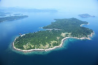
Grass Island or Tap Mun is an island in Hong Kong, located in the northeastern part of the territory. Its area is 1.69 km2 (0.65 sq mi). Administratively, it is part of the Tai Po District. There are about 100 people living on the island, and feral cattle are known on the island.

The Sai Kung Peninsula is a peninsula in the easternmost part of the New Territories in Hong Kong. Its name comes from Sai Kung Town in the central southern area of the peninsula. The southern part of the peninsula is administered by Sai Kung District, the north by Tai Po District and the northwest by Sha Tin District.

Tolo Harbour, or Tai Po Hoi, is a sheltered harbour in northeast New Territories of Hong Kong.

Tai Po is an area in the New Territories of Hong Kong. It refers to the vicinity of the traditional market towns in the area presently known as Tai Po Old Market or Tai Po Kau Hui (大埔舊墟) on the north of Lam Tsuen River and the Tai Po Hui on Fu Shin Street on the south of the Lam Tsuen River, near the old Tai Po Market railway station of the Kowloon-Canton Railway. Both market towns became part of the Tai Po New Town in the late 1970s and early 1980s. In present-day usage, "Tai Po" may refer to the area around the original market towns, the Tai Po New Town, or the entire Tai Po District.
Tai Po New Town, or Tai Po Town, is a new town and non-administrative area in Tai Po District, in the New Territories, Hong Kong. The area is a planned town that surrounding the existing indigenous market towns Tai Po Hui and Tai Po Kau Hui, as well as east of the existing indigenous villages that located on the Lam Tsuen Valley as well as west of those villages in Ting Kok and Tai Mei Tuk and south of those villages in Nam Hang, Fung Yuen and Sha Lo Tung. Most of the lands of the new town were obtained by land reclamation. In present day, Tai Po New Town was simply known as Tai Po. The new town are largely covered by the government Tai Po Outline Zoning Plan, which legally regulated the land use of the area, on top of the terms in the land lease contract with the government. Some of the land lease within the area, were known as Tai Po Town Lot № foo. In election, the town had a different zoning scheme for the election constituencies.

High Island or Leung Shuen Wan Chau is a former island located in the southeast of Sai Kung Peninsula in Hong Kong, within Sai Kung District. Two sets of dams constructed between 1969 and 1979 and crossing the former Kwun Mun Channel (官門海峽), connect the island to the peninsula, thereby forming the High Island Reservoir. Before being connected to the mainland, the island had an area of 8.511 km² (3.29 square miles) and was the 4th largest island of Hong Kong in 1960.

Rocky Harbour or Leung Shuen Wan Hoi is a harbour at the south-east of Sai Kung Peninsula, Hong Kong.
Articles related to Hong Kong include:

Middle Island, also known as Tong Po Chau is an island of Hong Kong. Administratively, it is part of Southern District.

Yim Tin Tze is a small offshore island in Sai Kung District, Hong Kong.
Yim Tin Tsai is an island of Hong Kong located in Tolo Harbour.

Aberdeen is an area on southwest Hong Kong Island in Hong Kong. Administratively, it is part of the Southern District. While the name "Aberdeen" could be taken in a broad sense to encompass the areas of Aberdeen (town), Wong Chuk Hang, Ap Lei Chau, Tin Wan, Wah Kwai Estate and Wah Fu Estate, it is more often used to refer to the town only. According to the population census conducted in 2011, the total population of the Aberdeen area is approximately 80,000.

Yuk Hui Temple also known as Pak Tai Temple (北帝廟), is a Taoist temple located on the island of Cheung Chau, Hong Kong. The temple address is Pak She Street, Tung Wan, Cheung Chau.

Centre Island or A Chau is a small uninhabited island of Hong Kong located in Tolo Harbour, in the northwestern part of the territory. Administratively, it is part of Tai Po District.

Several fishermen villages were established in Hong Kong to house fishermen families.

