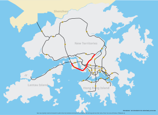
The Islands District is one of the 18 districts of Hong Kong. It is part of the New Territories. It had a population of 170,900 in 2018.

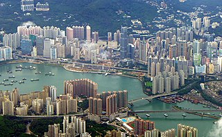
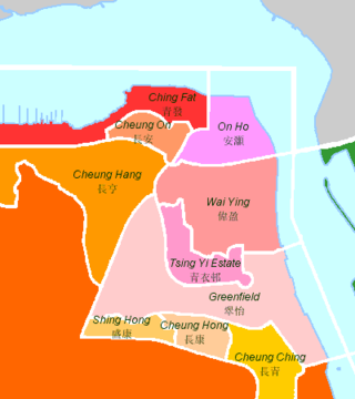
Tsing Yi, sometimes referred to as Tsing Yi Island, is an island in the urban area of Hong Kong, to the northwest of Hong Kong Island and south of Tsuen Wan. With an area of 10.69 km2 (4.13 sq mi), the island has extended drastically by reclamation along almost all its natural shore and the annexation of Nga Ying Chau (牙鷹洲) and Chau Tsai. Three major bays or harbours, Tsing Yi Lagoon, Mun Tsai Tong and Tsing Yi Bay (青衣灣) in the northeast, have been completely reclaimed for new towns.

Tsuen Wan District is one of the 18 districts of Hong Kong. It is located in the New Territories and is served by the Tsuen Wan line of the MTR metro system. Its area is 60,7 km². Its residents, who mostly live in Tsuen Wan Town, enjoy the highest income in the New Territories.

Rambler Channel is a body of water in Hong Kong that separates Tsing Yi Island from Tsuen Wan and Kwai Chung in the New Territories. The channel separates the two landmasses by 900 metres at its widest point.
Tsing Yi Lagoon, or Tsing Yi Tong, was a lagoon on the east shore of Tsing Yi Island in Hong Kong. Its water came from a stream in the nearby valley of Liu To and its outlet was at Tsing Yi Bay. It acted as the shelter for nearby boat people, especially after large-scale land reclamation in Tsuen Wan and Kwai Chung. Once their boats moved into the lagoon, they never moved out. This was because their boats were too old for fishing far away. The lagoon was unable to escape the fate of development. Both the lagoon and the neighbouring Tsing Yi Bay, were reclaimed for new towns. The boat people were forced to give up their boats and were relocated to public housing estate on the island. After reclamation, the northern portion became Tsing Yi Estate and the remainder became temporary housing areas, which were later demolished.

Tsing Yi Bay was a bay on the east side of Hong Kong's Tsing Yi Island, beside the Rambler Channel, approximately on the site of modern-day Tsing Yi Park. The whole bay was reclaimed for the development of new town. Before reclamation, it was surrounded by places known as Tsing Leng Tsui, Sheung Ko Tan (上高灘), Ha Chung Mei, Tai Wong Ha and Tsing Yi Town. The names of these places have since changed, and can now be translated, approximately, as Grand Horizon, Green Field Garden, Fung Shue Wo Road, Tsing Yi Estate and Tsing Yi Garden.
Tsing Leng Tsui is a former cape on Tsing Yi Island, Hong Kong between the former Tsing Yi Bay and the Rambler Channel. After several phases of reclamation, the cape lost its shape and became the location of the Hong Kong Cement Plant belonging to Hong Kong Cement Manufacturing Company Limited. The area changed to a promenade and the Grand Horizon residential estate after the plant was relocated to Ngau Kok Wan (牛角灣), northwest of the island, owing to environmental concerns voiced by residents of neighbouring Greenfield Garden.

Hongkong United Dockyards abbreviated to United Dockyards (聯合船塢) or HUD is a dockyard built on the site of the former Shek Wan or "Stone Bay", on Tsing Yi Island of Hong Kong.

Tsuen Wan is a town built on a bay in the western New Territories of Hong Kong, opposite of Tsing Yi Island across Rambler Channel. The market town of Tsuen Wan emerged from the surrounding villages and fleets of fishing boats in the area. The now-crowded city is around the present-day Tsuen Wan station of the MTR. Its coastline was further extended through land reclamation.

Tsing Yi Peak, also known as Sam Chi Heung, is a hill with three peaks occupying the southern half of the Tsing Yi Island, Hong Kong. The hill is situated on the western half of Victoria Harbour. Its peaks are good locations to observe the harbour and the channels among harbour islands. While situated in the south, a short hill Liu To Shan occupies the northwest of the island.
Articles related to Hong Kong include:

The following is an overview of public housing estates on Tsing Yi, Hong Kong including Home Ownership Scheme (HOS), Private Sector Participation Scheme (PSPS), Flat-for-Sale Scheme (FFSS), Tenant Purchase Scheme (TPS) and Subsidised Sale Flats Project (SSFP) estates.

Chung Mei is an area on the Tsing Yi Island in Hong Kong. It is also the name of a village on the island.
The 2009–10 Hong Kong Football Association First Division League was the 98th top tier football league of Hong Kong. Because of the renovation of Mong Kok Stadium which will last for two league seasons, the current First Division League has allocated eight stadia for the eleven participating teams to play their home games.

Tsing Sha Highway is a major expressway in Hong Kong, which links the island of Tsing Yi to Sha Tin. The road is part of Route 8, which starts in Sha Tin and terminates in Tung Chung. It was opened in March 2008 and extended in December 2009.

Heung Fan Liu is an area in Tai Wai, Sha Tin District, Hong Kong.


