Shing Mun River | |
---|---|
Physical characteristics | |
Mouth | |
• location | Tide Cove |
Length | 7 km (4.3 mi) |
Shing Mun River | |||||||||||||||||
---|---|---|---|---|---|---|---|---|---|---|---|---|---|---|---|---|---|
Traditional Chinese | 城門河 | ||||||||||||||||
Simplified Chinese | 城门河 | ||||||||||||||||
|
The Shing Mun River or Shing Mun River Channel is a river in Sha Tin,Hong Kong.
The original Shing Mun River began at Needle Hill,and flowed into the former Tide Cove (Sha Tin Hoi),a shallow bay. In the 1970s,Tide Cove was reclaimed and turned to Sha Tin New Town. The river was extended through a 7 km long,200 m wide artificial channel in the middle of the area to flow into Tolo Harbour. Other rivers that had originally flowed into Tide Cove are now tributaries of Shing Mun River in the form of concreted nullahs.
The Shing Mun River channel runs from the Tai Wai area,through the Sha Tin town centre to the Tolo Harbour. It has three main tributaries,namely Tai Wai Nullah,Fo Tan Nullah and Siu Lek Yuen Nullah. Along the Shing Mun River are high-rise residential,commercial and industrial buildings with numerous village-type developments such as City One Shatin and Wo Che Estate scattered around. Several bridges were built to connect the two sides of the Shing Mun River.
There are several major bridges across the Shing Mun River:
Although the river is primarily designed for the drainage of storm water from Sha Tin with a catchment area of 37 km2,it is also a popular place for recreational users such as rowers,anglers,riverside walkers and cyclists. There are continuous pedestrian promenades on both sides of the river.
Many species of trees has been planted along the riverside,such as the Chinese Banyan and a few cotton trees.
Shing Mun River is a popular place for water sports,such as:rowing,canoeing,kayaking and dragon boat racing. There are three boathouses in the river,located at Yuen Wo Road and Shek Mun respectively. The river has a standard of 2000 metres long for regattas.
The Shing Mun River was once heavily polluted from the indiscriminate discharges from livestock,industrial,commercial and domestic sources. [4] The total organic pollution load from these discharges amount to a population equivalent of 160,000 in the 1980s. At that time,hardly any living creatures were found in the river.
The water quality of Shing Mun River has improved from bad to good in terms of the Water Quality Index since 1993. Lifeforms including fish and invertebrates have also reappeared in the river. In 2001,bioremediation and dredging works began to further improve the river environment. Levels of odour-causing sulphides and E. coli subsequently dropped sharply. But the water quality is still threatened by the polluted condition of Tolo Harbour,which backflows into the Shing Mun River during high tide,causing contamination. [5]
An artificial river bank was also built along a 250-metre section near Man Lai Court,where there are relatively severe sediment accumulations and odour problems.
In late 2015,the Fo Tan Nullah,which flows into the Shing Mun River,changed colours several times. In early December it turned an electric blue,while later in the month it was ‘partly grey and partly turquoise’. [6] [7] Residents and green groups speculated on whether the pollution was caused by the illegal dumping of pigments or industrial waste. The Environmental Protection Department (EPD) and Drainage Services Department investigated but were unable to determine the cause of the pigmentation as of December 2015. [6] [7] An EPD test revealed that the river was polluted by sewage. [8]
Aside from the colour changes in the Fo Tan Nullah,tests conducted in December 2015 by a private laboratory at the behest of Sha Tin District Councillor Scarlett Pong Oi-lan revealed that pollution had worsened in the Shing Mun River. The tests showed that the E. coli are 1,300 times the EPD standard,while water acidity and suspended solids are three times the standard. [8] Pong said that the E. Coli concentration was at its highest level since 1995. [8]
In early 2016,thousands of fish died in the river. [9]
On 1 November 2016,the real estate company Link REIT was fined $15,000 for contravening the Water Pollution Control Ordinance because wastewater from the Mei Lam Shopping Centre,owned and managed by Link REIT,was being illegally discharged into the Shing Mun River. [10] The company was ordered to rectify the situation immediately.
Hong Kong has a long coastline that is full of twists and turns with many bays and beaches. Many of them are well sheltered by mountains nearby,as Hong Kong is a mountainous place. As a result,large waves seldom appear at the bays,making them suitable for human swimming.
Sha Tin District is one of the 18 districts of Hong Kong. As one of the 9 districts located in the New Territories,it covers the areas of Sha Tin,Tai Wai,Ma On Shan,Fo Tan,Siu Lek Yuen,Kwun Yam Shan and Ma Liu Shui. The district is the most populous district in Hong Kong,with a population of 659,794 as per 2016 by-census,having a larger population than many states or dependencies including Iceland,Malta,Montenegro and Brunei.
Fo Tan is an area of Sha Tin District,New Territories,Hong Kong. It was developed as a light industrial area,but this activity has declined markedly in recent years. There are residential areas to the east,alongside the MTR line,and in the foothills to the west.
Tolo Harbour,or Tai Po Hoi is a sheltered harbour in northeast New Territories of Hong Kong.
Route 9,Hong Kong is one of the strategic trunk roads,mostly in the form of a motorway,circumnavigating the New Territories. The route is also known as the New Territories Circular Road (新界環迴公路). Starting from the Shing Mun Tunnels,Route 9 links Sha Tin,Tai Po,Fanling,Sheung Shui,Yuen Long,Tuen Mun and Tsuen Wan. The section between Exit 10 in Kwu Tung and Exit 16 in Lam Tei is part of Asian Highway 1,although the Asian Highway Network is not signed in Hong Kong.
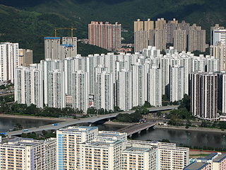
City One Shatin is a residential precinct in Sha Tin,New Territories,Hong Kong. The estate occupies approximately 1,800,000 square feet of land. The estate was named City One as it is on Lot 1,Shatin Town. It has a census area population of 24,758 people. City One is the largest private residential estate in Sha Tin District. There are a total of 52 blocks of residential buildings with 10,642 units. Each tower is about 30 storeys with units ranging from 389 square feet (36.1 m2) to an area of 1,018 square feet (94.6 m2),offering different floor plans.
Route 1 is a major artery in Hong Kong that runs in a generally north-south direction,connecting Aberdeen with Sha Tin.
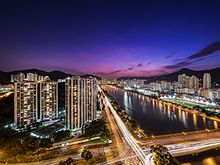
Sha Tin,also spelt Shatin,is a neighbourhood along Shing Mun River in the eastern New Territories,Hong Kong. Administratively,it is part of the Sha Tin District. Sha Tin is one of the neighbourhoods of the Sha Tin New Town project.
Sha Tin New Town,or known as Sha Tin-Ma On Shan New Town or Sha Tin Town is one of the satellite towns and new towns of Hong Kong. It is within the Sha Tin District,the New Territories. The New Town covers the neighbourhoods such as Sha Tin,Tai Wai,Fo Tan,Tai Shui Hang,Ma On Shan. The Shing Mun River runs through the middle of the town.
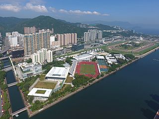
Sha Tin Hoi / Sha Tin Sea or Tide Cove is a cove at the mouth of the Shing Mun River. It is between Ma Liu Shui and Ma On Shan. The cove is open to Tolo Harbour. It was largely reclaimed for the development of Sha Tin New Town.
Tai Wai Nullah,sometimes referred to as the upper stream of Shing Mun River,is one of the nullahs of Shing Mun River in Tai Wai of Hong Kong.
Sha Tin Airfield was a small military airfield in Sha Tin,New Territories,Hong Kong,which had a single concrete runway. The airfield was located along the Shing Mun River and looked out to Tide Cove. The airfield served as a Flight location for most of the location's existence.
ClubONE Riviera,formerly called Star Seafood Restaurant (明星海鮮舫),and earlier called Treasure Floating Restaurant (敦煌畫舫),is a restaurant in Sha Tin,Hong Kong. The restaurant was built with granite taking on the shape of a ship berthing along the shore. The building is situated at the eastern shore of Shing Mun River,near the junction of Siu Lek Yuen Road and Tai Chung Kiu Road. It served Cantonese dim sum and seafood.
Siu Lek Yuen is an area in Sha Tin District,New Territories East. Located to the east of Yuen Chau Kok,the area is surrounded on three sides by the Ma On Shan Country Park. Nowadays it is a residential area.
Articles related to Hong Kong include:
Lek Yuen Bridge is a pedestrian footbridge in Sha Tin New Town,New Territories,Hong Kong,across the Shing Mun River.
The Sand Martin Bridge is one of Hong Kong's bridges,part of the Sha Tin Rural Committee Road,named after the Shatin Martins,the first baseball team from Hong Kong to win a league. The Sand Martin bridge crosses the Shing Mun River,connecting Sha Tin Town Centre with Sha Tin Wai.
High on the agenda is the polluted Shing Mun River, down which dung, carcasses and refuse flow. So bad is the pollution that the large Tolo Harbour reeks with industrial and agricultural rubbish.