Drainage Services Department

Last updated

Drainage Services Department
渠務署
Drainage Services Department logo.png
Government department overview
Formed1989
Headquarters Revenue Tower
No. 5 Gloucester Road, Wan Chai
Employees2,064 (March 2022) [1]
Annual budgetHK$3,447 million 2022-23 FY [1]
Government department executive
  • Alice Pang, from 4 Nov. 2020 [2] , Director of Drainage Services
Website dsd.gov.hk
Drainage Services Department
Traditional Chinese 渠務署
Simplified Chinese 渠务署
The Sha Tin Sewage Treatment Works. Shatin Sewage Treatment Works Aerial view 201712.jpg
The Sha Tin Sewage Treatment Works.

The Drainage Services Department (DSD) is a department of the Hong Kong Government responsible for drainage and sewerage. Since 2007 it has been subordinate to the Development Bureau.

Contents

Responsibilities

The department is responsible for stormwater drainage, sewage collection and treatment, and flood prevention.

History

Environmental protection was one of the main concerns of former governor David Wilson. [3] Wilson stressed the importance of better planning, increased control of pollution discharges, and large-scale investment in improved sewage disposal infrastructure. He stated that Hong Kong needed more treatment facilities and new outfalls constructed sufficiently far out to sea, and promoted a new department to help achieve this. [3] The Drainage Services Department was established in 1989.

Major infrastructure works

Harbour Area Treatment Scheme

The Harbour Area Treatment Scheme (HATS) is a major sewage treatment infrastructure improvement scheme designed to improve the water quality of Victoria Harbour. Originally called the Strategic Sewage Disposal Scheme, the plan was drawn up in 1989 and construction of HATS Stage 1 commenced in 1994. It comprises a system of deep tunnels to convey sewage from eight Preliminary Treatment Works to the Stonecutters Island Sewage Treatment Works, which opened in 1997. The full Stage I system, which treats 75% of the sewage generated by the urban areas around the harbour, came online in December 2001. Construction of HATS Stage 2 commenced in 2008, and stage 2A was commissioned in 2015. HATS Stage 2B, comprising an underground biological treatment facility at Stonecutters Island, has been shelved as it is felt that the existing facility is sufficient at this time. [4]

Drainage tunnels

The department has built several significant bored tunnels designed to intercept water running down mountain slopes and divert it from urban areas in order to prevent flooding.

The largest of these is the Hong Kong West Drainage Tunnel, comprising an 11-kilometre long main tunnel and 8 km of adits. It stretches from Tai Hang in the east to an outfall just north of Cyberport. It was built at a cost of HK$3.4 billion. Construction commenced in November 2007 and the tunnel was commissioned on 22 August 2012. [5]

The Lai Chi Kok Drainage Tunnel encircles Sham Shui Po and Lai Chi Kok. It is a 3.7-kilometre tunnel, stretching from Shek Kip Mei to an outfall near Stonecutters Island, built at a cost of $1.7 billion. Construction commenced in November 2008 and the tunnel was commissioned on 18 October 2012. [6]

The Tsuen Wan Drainage Tunnel protects the Tsuen Wan New Town and Kwai Chung areas. The 5.1-kilometre tunnel begins at Wo Yi Hop, north of Kwai Chung, and curves around the north of Tsuen Wan proper. Past Chai Wan Kok, it parallels the Tuen Mun Highway a short distance and then empties into the Rambler Channel. Construction of the $1.5 billion tunnel commenced in 2007. It was commissioned on 28 March 2013. [7]

Vessels

The department operates two sludge transport vessels, called Clean Harbour 1 and Clean Harbour 2. These ships transport sludge from the Stonecutters Island Sewage Treatment Works to the sludge treatment facility in Tuen Mun. [8]

The ships are equipped with gantry cranes capable of lifting sludge from the lorries directly into containers on board, and can lift 10 containers per hour. Each ship can carry 90 containers of sludge, a total of 1,200 tons of sludge. The vessels were built by Jinhui Shipbuilding of Zhongshan and commissioned in 2015. [9]

Clean Harbour 1

Clean Harbour 1 Clean Harbour 1.jpg
Clean Harbour 1

Clean Harbour 2

Related Research Articles

<span class="mw-page-title-main">Tsing Yi</span> Island in Hong Kong

Tsing Yi, sometimes referred to as Tsing Yi Island, is an island in the urban area of Hong Kong, to the northwest of Hong Kong Island and south of Tsuen Wan. With an area of 10.69 km2 (4.13 sq mi), the island has extended drastically by reclamation along almost all its natural shore and the annexation of Nga Ying Chau (牙鷹洲) and Chau Tsai. Three major bays or harbours, Tsing Yi Lagoon, Mun Tsai Tong and Tsing Yi Bay (青衣灣) in the northeast, have been completely reclaimed for new towns.

<span class="mw-page-title-main">Tsuen Wan line</span> Hong Kong MTR railway line

The Tsuen Wan line is one of the ten lines of the metro network in Hong Kong's MTR. It is indicated in red on the MTR map.

<span class="mw-page-title-main">Stonecutters Island</span> Former island in Victoria Harbour, Hong Kong

Stonecutters Island or Ngong Shuen Chau is a former island in Victoria Harbour, Hong Kong. Following land reclamation, it is now attached to the Kowloon Peninsula.

<span class="mw-page-title-main">Rambler Channel</span>

Rambler Channel is a body of water in Hong Kong that separates Tsing Yi Island from Tsuen Wan and Kwai Chung in the New Territories. The channel separates the two landmasses by 900 metres at its widest point.

<span class="mw-page-title-main">Port of Hong Kong</span> Port in Hong Kong

The Port of Hong Kong located by the South China Sea, is a deepwater seaport dominated by trade in containerised manufactured products, and to a lesser extent raw materials and passengers. A key factor in the economic development of Hong Kong, the natural shelter and deep waters of Victoria Harbour provide ideal conditions for berthing and the handling of all types of vessels. It is one of the busiest ports in the world, in the three categories of shipping movements, cargo handled and passengers carried. This makes Hong Kong a Large-Port Metropolis.

This article is a list of transport means that cross Victoria Harbour in Hong Kong.

<span class="mw-page-title-main">Stonecutters Bridge</span> Bridge in Hong Kong

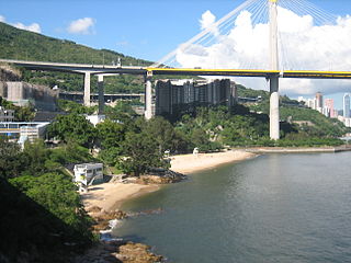
Stonecutters Bridge is a high level cable-stayed bridge spanning the Rambler Channel in Hong Kong, connecting Nam Wan Kok, Tsing Yi to Stonecutters Island. The bridge deck was completed on 7 April 2009, and opened to traffic on 20 December that year. The bridge was the second-longest cable-stayed span in the world at the time of its completion.

<span class="mw-page-title-main">Airport Core Programme</span>

The Airport Core Programme was a series of infrastructure projects centred on the new Hong Kong International Airport during the early 1990s. The programme was part of the Port and Airport Development Strategy, commonly known as the Rose Garden Project.

<span class="mw-page-title-main">Sham Shui Po District</span> District in Hong Kong, China

Sham Shui Po District is one of 18 districts of Hong Kong. It is the second poorest district in Hong Kong, with a predominantly working-class population of 405,869 in 2016 and the lowest median household income of all districts. Sham Shui Po has long been home to poorer new immigrants from mainland China. It also saw the birth of public housing in Hong Kong, as the government sought to resettle those displaced by a devastating fire in its slums. Sham Shui Po also hosted a Vietnamese refugee camp during the influx of migration in the aftermath of the Vietnam War.

<span class="mw-page-title-main">Kwai Chung Road</span>

Kwai Chung Road is a throughway in Kwai Chung of the New Territories in Hong Kong. It is one of the busiest roads in Hong Kong. The Transport Department has classified it as a trunk road.

<span class="mw-page-title-main">Route 5 (Hong Kong)</span> Road in Hong Kong

Route 5 is a strategic route in Hong Kong from eastern to western Kowloon and New Kowloon, and ends in Tsuen Wan in the New Territories where it connects to Route 9. It is one of the most seriously congested routes in Kowloon, as it serves as an interchange to the Hung Hom Cross-Harbour Tunnel, especially during peak hours.

<span class="mw-page-title-main">Hong Kong Strategic Route and Exit Number System</span> Trunk road numbering system in Hong Kong

The Hong Kong Strategic Route and Exit Number System is a system adopted by the Transport Department of the Hong Kong Government to organise the major roads in the territory into routes 1 to 10 for the convenience of drivers. When the system was implemented in 2004, the government promoted it with a major public campaign, including the slogan "Remember the Numbers; Make Driving Easier".

Jardine Engineering Corporation (JEC) is a private limited company and wholly owned subsidiary of the Jardine Pacific, a member of Jardine Matheson Holdings Limited. Originally established in Shanghai in 1923 to support the group's engineering operations in China. Previously, this had been done by the group's engineering department.

<span class="mw-page-title-main">Cheung Shan Estate</span> Public housing estate in Tsuen Wan, Hong Kong

Cheung Shan Estate is a public housing estate located between Shek Wai Kok Estate and Lei Muk Shue Estate, and near Shing Mun Valley Park and Shing Mun Tunnels in Tsuen Wan, New Territories, Hong Kong. Formerly the site of Cheung Pei Shan Temporary Housing Area, it consists of three residential buildings completed in 1978.

<span class="mw-page-title-main">Lido Beach (Hong Kong)</span> Beach in Ting Kau, New Territories, Hong Kong

Lido Beach is located on Castle Peak Road in Ting Kau, New Territories, Hong Kong. It is a gazetted beach, meaning it is managed by the Leisure and Cultural Services Department, which provides lifeguards during the summer months.

<span class="mw-page-title-main">Hoi Mei Wan Beach</span> Beach in Ting Kau, New Territories, Hong Kong

Hoi Mei Wan Beach is a gazetted beach located near Airport Core Programme Exhibition Centre on Castle Peak Road in Ting Kau, New Territories, Hong Kong. The beach has barbecue pits and is managed by the Leisure and Cultural Services Department of the Hong Kong Government. The beach is rated as Grade 2 by the Environmental Protection Department for its water quality. The beach offers views of the Ting Kau Bridge as well as Tsing Ma Bridge.

<span class="mw-page-title-main">Approach Beach</span> Beach in Ting Kau, New Territories, Hong Kong

Approach Beach is a gazetted beach located near Yau Kom Tau on Castle Peak Road in Ting Kau, New Territories, Hong Kong. The beach has barbecue pits and is managed by the Leisure and Cultural Services Department of the Hong Kong Government. The beach is rated as Grade 2 by the Environmental Protection Department for its water quality.

References

  1. 1 2 "Estimates for the year ending 31 March 2023". The 2022-23 Budget.
  2. "Senior appointments". 3 November 2020.
  3. 1 2 "Ambitious $10 billion sewage plan". South China Morning Post. 13 October 1988. p. 8.
  4. "Harbour Area Treatment Scheme". Hong Kong Government. Archived from the original on 30 December 2015. Retrieved 7 March 2017.
  5. "Hong Kong West Drainage Tunnel commissioned". Hong Kong Government. 22 August 2012.
  6. "Lai Chi Kok Drainage Tunnel commissioned". Hong Kong Government. 18 November 2012.
  7. "Tsuen Wan Drainage Tunnel commissioned". Hong Kong Government. 28 March 2013.
  8. "Maiden voyage of DSD's sludge vessel Clean Harbour 1". Hong Kong Government. 5 March 2015.
  9. "净港1号顺利下水". Jin Hui Ship Repair and Building Factory. 14 October 2014. Archived from the original on 22 November 2015.

Further reading