
The Southern District is one of the 18 districts of Hong Kong. It is located in the southern part of Hong Kong Island and the largest part of the island. It had a population of 274,994 in 2016.

Happy Valley is an upper-income residential area in Hong Kong, located on Hong Kong Island. The area is bordered by Caroline Hill to the east, Jardine's Lookout to the south, Morrison Hill to the west, and Causeway Bay to the north. Administratively, it is part of Wan Chai District.
Connaught Road is a major thoroughfare on the north shore of Hong Kong Island, Hong Kong. It links Shing Sai Road in Kennedy Town to the west and Harcourt Road in Admiralty to the east.
Route 1 is a major artery in Hong Kong that runs in a generally north-south direction, connecting Aberdeen with Sha Tin.

Canal Road East, Canal Road West (堅拿道西) and the Canal Road Flyover (堅拿道天橋) are important roads in the Wan Chai District of Hong Kong Island, between the areas of East Point near Causeway Bay, and Morrison Hill near Wan Chai.

Nam Long Shan or Brick Hill is a hill on the Hong Kong Island of Hong Kong, near Wong Chuk Hang and Aberdeen. At an elevation of 282 metres, it overlooks the South China Sea in the south, Sham Wan and Aberdeen Channel in the west, and Deep Water Bay in the east.

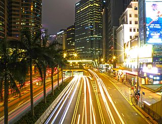
Gloucester Road is a major highway in Hong Kong. It is one of the few major roads in Hong Kong with service roads. It was named on 14 June 1929 after Prince Henry, Duke of Gloucester, to commemorate his visit to Hong Kong that year. The road is 2.2 kilometres in length and has a speed limit of 70 km/h.

Aberdeen Tunnel, part of Route 1, is a two-tube tunnel linking Happy Valley and Wong Chuk Hang near Aberdeen on the Hong Kong Island, Hong Kong. It shortens the travel time between Wong Chuk Hang and Causeway Bay of the Hong Kong Island. It connects the Wong Chuk Hang Road and Canal Road Flyover in the Hong Kong Island. The toll plaza is at the Wong Chuk Hang end.

Wong Chuk Hang is a neighbourhood in the Southern District of Hong Kong Island, in Hong Kong.

Lung Cheung Road is a major road in New Kowloon, Hong Kong. It forms part of Route 7 linking Kwun Tong Road at Ngau Chi Wan and Ching Cheung Road near Tai Wo Ping. It is a dual 3-lane carriageway running in the east-west direction for its entire length.

The Hong Kong Strategic Route and Exit Number System is a system adopted by the Transport Department of the Hong Kong Government to organise the major roads in the territory into routes 1 to 10 for the convenience of drivers. When the system was implemented in 2004, the government promoted it with a major public campaign, including the slogan "Remember the Numbers; Make Driving Easier".

Shouson Hill is a hill on the coast of Deep Water Bay east of Wong Chuk Hang, in Southern District, on Hong Kong Island in Hong Kong.
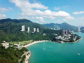
Deep Water Bay is a bay and residential area on the southern shore of Hong Kong Island in Hong Kong. The bay is surrounded by Shouson Hill, Brick Hill, Violet Hill and Middle Island. As per Forbes, with 19 of the city's richest billionaires, it is reputed to be the "wealthiest neighborhood on earth". The neighborhood is bordered on the east by Repulse Bay Road heading to the Island Road roundabout, on the south by Island Road facing toward Middle Island and Deep Water Bay, on the west by Deep Water Bay Road, and on the north by Deep Water Bay Road as it connects back toward Repulse Bay Road.

KMB Route 1 is a bus route operated in Kowloon, Hong Kong. It is run by Kowloon Motor Bus and connects the Star Ferry Pier and Chuk Yuen Estate in Wong Tai Sin. The bus runs via Tsim Sha Tsui, Yau Ma Tei, Mong Kok, Kowloon City and Lok Fu.
Aberdeen is an area on southwest Hong Kong Island in Hong Kong. Administratively, it is part of the Southern District. While the name "Aberdeen" could be taken in a broad sense to encompass the areas of Aberdeen (town), Wong Chuk Hang, Ap Lei Chau, Tin Wan, Wah Kwai Estate and Wah Fu Estate, it is more often used to refer to the town only. According to the population census conducted in 2011, the total population of the Aberdeen area is approximately 80,000.

Mount Cameron is a 439-metre (1,440 ft) high hill in Hong Kong. Located within the Aberdeen Country Park, it was likely named for Major General William Gordon Cameron, British Army officer and former Administrator of Hong Kong.
The history of the South Island line and West Island line encompasses a number of proposals which were made for extending the Hong Kong MTR metro system to the south and west of Hong Kong Island, which were not serviced by any rail transport before 2014. The West Island line opened as an extension of the Island line on 28 December 2014. The South Island line has completed construction and commenced service on 28 December 2016. The proposed South Island line (West) is still in the planning phase and is expected to begin in 2021.
Wong Chuk Hang San Wai is a village in the Wong Chuk Hang area of Southern District, Hong Kong. It is located at the bottom of Shouson Hill.

Staunton Creek is a neighbourhood in the Southern District of Hong Kong Island, in Hong Kong. It is west of Wong Chuk Hang, north of Sham Wan, and east of Aberdeen.

