Wan Chai is located at the western part of Wan Chai District on the northern shore of Hong Kong Island, in Hong Kong. Its other boundaries are Canal Road to the east, Arsenal Street to the west and Bowen Road to the south. The area north of Gloucester Road is often referred to as Wan Chai North.

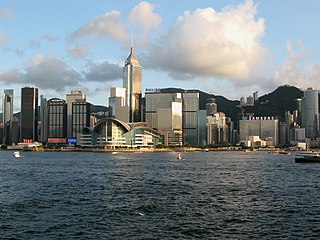
Central, also known as Central District, is the central business district of Hong Kong. It is located in the northeastern corner of the Central and Western District, on the north shore of Hong Kong Island, across Victoria Harbour from Tsim Sha Tsui, the southernmost point of Kowloon Peninsula. The area was the heart of Victoria City, although that name is rarely used today.

The Island line is one of ten lines of the MTR, the mass transit system in Hong Kong. It runs from Kennedy Town in the Western district to Chai Wan in the Eastern District on Hong Kong Island, passing through the territory's major business districts of Central, Wan Chai and Causeway Bay, and connecting them with built-up areas on the north shore of the island.
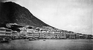
The City of Victoria, often called Victoria City or simply Victoria, was the de facto capital of Hong Kong during its time as a British dependent territory. It was initially named Queenstown but was soon known as Victoria. It was one of the first urban settlements in Hong Kong and its boundaries are recorded in the Laws of Hong Kong. All government bureaux and many key departments still have their head offices located within its limit.
Admiralty is the eastern extension of the central business district on the Hong Kong Island of Hong Kong. It is located on the eastern end of the Central and Western District, bordered by Wan Chai to the east and Victoria Harbour to the north.

Mid-Levels is an affluent residential area on Hong Kong Island in Hong Kong. It is located between Victoria Peak and Central. Residents are predominantly more affluent Hong Kong locals and expatriate professionals.

Central is an MTR station located in the Central area of Hong Kong Island. The station's livery is firebrick red but brown on the Tsuen Wan line platforms. The station is the southern terminus of the Tsuen Wan line, a stop on the Island line, and connects to Hong Kong station, which serves the Tung Chung line and the Airport Express.
Connaught Road is a major thoroughfare on the north shore of Hong Kong Island, Hong Kong. It links Shing Sai Road in Kennedy Town to the west and Harcourt Road in Admiralty to the east.

The Wan Chai Pier, or Wan Chai Ferry Pier, is a pier at the coast of Wan Chai North on the Hong Kong Island of Hong Kong. The pier is operated by Star Ferry, and provides ferry services to Tsim Sha Tsui. The pier is near the Hong Kong Convention and Exhibition Centre.

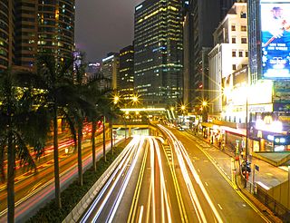
Gloucester Road is a major highway in Hong Kong. It is one of the few major roads in Hong Kong with service roads. It was named on 14 June 1929 after Prince Henry, Duke of Gloucester, to commemorate his visit to Hong Kong that year. The road is 2.2 kilometres in length and has a speed limit of 70 km/h.

Queen's Road East is a street in Wan Chai, in the north of Hong Kong Island, Hong Kong, connecting Admiralty in the west to Happy Valley in the east. Queen's Road East is one of the four sections of Queen's Road, and historically included Queensway.

Queensway is a major road in the Admiralty area of Central, Hong Kong. It was originally a section of Queen's Road East and forms part of the continuum of Queen's Road that had been split into Queen's Road West, Queen's Road Central, Queensway, and Queen's Road East after World War II. At its western end it splits into Queen's Road Central and Des Voeux Road Central while at its eastern end it merges into Hennessy Road, at the junction with Queen's Road East.

Route 4 is an east-west road artery along the Hong Kong Island, Hong Kong. Formerly divided into routes 7 and 8, it was absorbed into Route 4 in 2004.

The Hong Kong Strategic Route and Exit Number System is a system adopted by the Transport Department of the Hong Kong Government to organise the major roads in the territory into routes 1 to 10 for the convenience of drivers. When the system was implemented in 2004, the government promoted it with a major public campaign, including the slogan "Remember the Numbers; Make Driving Easier".
Wellington Barracks was a military barracks located to the east of Garden Road in Admiralty, Hong Kong. One of many military complexes constructed by the British Army in the area, the land was returned to the Hong Kong government in the 1970s and gradually reverted to civilian use. As a result, the barracks was closed at the end of that decade, demolished in the mid-1980s and replaced with Harcourt Garden.

Central and Wan Chai Reclamation is a project launched by the government of Hong Kong since the 1990s to reclaim land for different purposes. This includes transportation improvements such as the Hong Kong MTR station, Airport Express Railway & Central-Wan Chai Bypass, as well as public recreation space such as the Central Harbourfront Event Space, Tamar Park and the Hong Kong Observation Wheel.
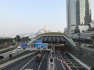
The Central–Wan Chai Bypass is a 4-kilometre (2.5 mi) trunk road running between Sheung Wan and Fortress Hill on Hong Kong Island. The original design consists of a 2.3 km dual three-lane tunnel running under new reclamation areas provided by the Central and Wan Chai Reclamation project, and also connections to Connaught Road West flyover and Island Eastern Corridor. It substitutes Connaught Road Central, Harcourt Road, Gloucester Road and Victoria Park Road to be part of Route 4.
The Central and Western District located on northwestern part of Hong Kong Island is one of the 18 administrative districts of Hong Kong. It had a population of 243,266 in 2016. The district has the most educated residents with the second highest income and the third lowest population due to its relatively small size.
Harcourt House, located on Gloucester Road in the Wan Chai area of Hong Kong, is a 27 floor Grade A commercial office building. It lies between Admiralty and Wan Chai MTR stations opposite the Hong Kong Academy for Performing Arts.

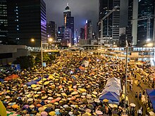
Umbrella Square, also called Umbrella Plaza, describes a large roadway in Admiralty, Hong Kong occupied by protesters during the Umbrella Movement protests in September 2014. On 11 December 2014, after 74 days of occupation, the area was cleared by the police and reopened to motorised traffic.