Hong Kong Island is an island in the southern part of Hong Kong. Known colloquially and on road signs simply as Hong Kong,the island had a population of 1,289,500 and a population density of 16,390 per square kilometre (42,400/sq mi),as of 2008. The island had a population of about 3,000 inhabitants scattered in a dozen fishing villages when it was occupied by the United Kingdom in the First Opium War (1839–1842). In 1842,the island was formally ceded in perpetuity to the UK under the Treaty of Nanking and the City of Victoria was then established on the island by the British Force in honour of Queen Victoria. The Central area on the island is the historical,political and economic centre of Hong Kong. The northern coast of the island forms the southern shore of the Victoria Harbour,which is largely responsible for the development of Hong Kong due to its deep waters favoured by large trade ships.

Tsing Yi,sometimes referred to as Tsing Yi Island,is an island in the urban area of Hong Kong,to the northwest of Hong Kong Island and south of Tsuen Wan. With an area of 10.69 km2 (4.13 sq mi),the island has been extended drastically by reclamation along almost all its natural shore and the annexation of Nga Ying Chau (牙鷹洲) and Chau Tsai. Three major bays or harbours,Tsing Yi Lagoon,Mun Tsai Tong and Tsing Yi Bay (青衣灣) in the northeast,have been completely reclaimed for new towns.

Sha Tin District is one of the 18 districts of Hong Kong. As one of the 9 districts located in the New Territories,it covers the areas of Sha Tin,Tai Wai,Ma On Shan,Fo Tan,Siu Lek Yuen,Kwun Yam Shan and Ma Liu Shui. The district is the most populous district in Hong Kong,with a population of 659,794 as per 2016 by-census,having a larger population than many states or dependencies including Iceland,Malta,Montenegro and Brunei.

Yau Ma Tei is an area in the Yau Tsim Mong District in the south of the Kowloon Peninsula in Hong Kong.

Tseung Kwan O New Town,commonly known as Tseung Kwan O,is one of the nine new towns in Hong Kong,built mainly on reclaimed land in the northern half of Junk Bay in southeastern New Territories,after which it is named.

Sheung Wan is an area in Hong Kong,located in the north-west of Hong Kong Island,between Central and Sai Ying Pun. Administratively,it is part of the Central and Western District. The name can be variously interpreted as Upper District,or Gateway District.

Kornhill and Kornhill Gardens are apartment buildings on the northern slope of Mount Parker,in Quarry Bay,Hong Kong Island,Hong Kong. Kornhill is a private housing estate and Kornhill Gardens is a Private Sector Participation Scheme estate. The total population is approximately 30,000.

Sai Ying Pun is a station on the MTR network. The station is located between HKU and Sheung Wan on the Island line. It serves the neighbourhood of Sai Ying Pun and the western part of Mid-Levels in northwestern Hong Kong Island,Hong Kong. Sai Ying Pun station was opened on 29 March 2015,completing the West Island line extension of the Island line.

Argyle Street is a four-lane dual-way thoroughfare in Kowloon,Hong Kong,connecting the districts of Mong Kok,Ho Man Tin,Ma Tau Wai and Kowloon City. It runs on an east-west alignment starting at its intersection with Cherry Street,Ferry Street and Tong Mi Road in the west,and ending near the former Kai Tak Airport in the east. Due to the street's proximity with the latter,a variety of aircraft could be seen from this street and thus photographers seized the opportunity to capture landing aircraft.

Sai Wan,also known as Western district,or simply Western, is an area in Hong Kong Island,Hong Kong that corresponds to Sai Ying Pun,Shek Tong Tsui,Belcher Bay and Kennedy Town. However,Some Hong Kong people consider Kennedy Town as the only part of Sai Wan. It formed part of the City of Victoria. West Point,a former cape where major government structures in Sai Wan are close to,also used to refer to Sai Wan.

Sai Ying Pun is an area in Sai Wan,on Hong Kong Island,in Hong Kong. It is administratively part of the Central and Western District.

Bonham Road is a main road in West Mid-Levels,Hong Kong Island in Hong Kong,running mainly East-West. The road connects Pok Fu Lam Road in the west,near the University of Hong Kong,and Caine Road in the east,at the junction with Hospital Road and Seymour Road. It was named after Sir George Bonham,the third Governor of Hong Kong. It was renamed Nishi-Taisho Dori (西大正通) during Japanese occupation of Hong Kong.

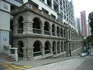
Sai Ying Pun Community Complex is located at 2 High Street,Sai Ying Pun,Hong Kong. It is a 9-storey building built on the site of the Old Mental Hospital,of which only the granite facade and arched verandah were preserved.
King George V Memorial Gardens may refer to:
Articles related to Hong Kong include:

King George V Memorial Park,Kowloon,is a park in Jordan,Kowloon,Hong Kong,located beside Canton Road. There are two parks of this name in Hong Kong. The other one is in Sai Ying Pun,Hong Kong Island.

The Grand Promenade is a high-rise residential development located at 38 Tai Hong Street,Sai Wan Ho,Hong Kong Island,Hong Kong. It is developed by Henderson Land Development and its subsidiary,The Hongkong and Yaumati Ferry Co Ltd. in 2005.

The Central and Western District located on northwestern part of Hong Kong Island is one of the 18 administrative districts of Hong Kong. It had a population of 243,266 in 2016. The district has the most educated residents with the second highest income and the third lowest population due to its relatively small size.


