Pok Fu Lam or Pokfulam is a residential area on Hong Kong Island, at the western end of the Southern District. It is a valley between Victoria Peak and Mount Kellett, around Telegraph Bay.
Shek Tong Tsui or Belcher Point is an area in Sai Wan on Hong Kong Island in Hong Kong. Administratively, it belongs to the Central and Western District.

Sai Wan is an area in Hong Kong Island, Hong Kong that corresponds to Sai Ying Pun, Shek Tong Tsui, Belcher Bay and Kennedy Town. However, Some Hong Kong people consider Kennedy Town as the only part of Sai Wan. It formed part of the City of Victoria. West Point, a former cape where major government structures in Sai Wan are close to, also used to refer to Sai Wan. After Hong Kong's handover to People's republic of China, Sai Wan become the location for Liaison Office of the Central People's Government in the Hong Kong Special Administrative Region and people in Hong Kong tend to refer the name Sai Wan as the PRC office itself..

HKU is a station on the Hong Kong MTR Island line located in the Lung Fu Shan and Shek Tong Tsui neighbourhoods of the Western District, Hong Kong. It is named after The University of Hong Kong, which is also served by the station.
Sai Ying Pun is an area in Western District, on Hong Kong Island, in Hong Kong. It is administratively part of the Central and Western District.

Pok Fu Lam Road, or Pokfulam Road, is a four-lane road in Hong Kong. Built on Hong Kong Island, the road runs between Sai Ying Pun and Wah Fu, through Pok Fu Lam.
High Street is a one-way street in Sai Ying Pun, Hong Kong, available only to minibuses and private vehicles. It connects Bonham Road in the east and Pok Fu Lam Road in the west. It runs from east to west from Western Street to Pok Fu Lam Road, and from west to east from Western Street to Bonham Road. It was originally named Fourth Street, but because the number four is commonly avoided in Chinese culture, the government changed the name to High Street.

Western Street is an uphill one-way street in Sai Ying Pun, Hong Kong. It connects Bonham Road in the south and Connaught Road West in the north. There are 337 units in 17 buildings in the street. Addresses are odd on the west side of the street, and mostly even on the east side. However, on the newer part of the street, on the reclamation north of Queen's Road West, the east side has both odd and even numbered addresses.

First Street is a street in Sai Ying Pun, an early suburb of Hong Kong.

Third Street, is a street in Sai Ying Pun neighbourhood of Hong Kong. It runs one way from Pok Fu Lam Road, then crosses Water Street, then Pok Fu Lam Road again, then Western Street, Centre Street and terminates at Eastern Street.
Second Street is a street in the Sai Ying Pun area of the Central and Western District on Hong Kong Island, in Hong Kong.

Centre Street is a street in the Sai Ying Pun area of Hong Kong. Centre Street is the central point of the most active traditional market in Western District of Hong Kong Island. The street is part of planned streets in the early development of the area.

Water Street is a street in Sai Ying Pun, Hong Kong. It runs from Connaught Road, crossing Des Voeux Road West and Queen's Road West then climbing steeply up the hill crossing Second Street, Third Street and then end in steps to High Street and Pok Fu Lam Road conjunction. Originally, there was a nullah in the middle of the street carrying water from the hills down to the harbour. With the development of the area, the nullah was covered and used for hot food hawkers market for many years and this was a favourable night meeting spot for professional drivers such as taxis and trucks to have their dinner and late night gathering until the foodstalls were removed to give way for more traffic lanes.
St. Stephen's Church College, 聖士提反堂中學, is a secondary school attached to the Anglican St Stephen's Church, Hong Kong, located between Bonham Road and Pok Fu Lam Road in Sai Ying Pun. The school's total enrollment in the academic year 2009-2010 was approximately 1,000, in 24 classes of two streams, across six forms/grades.
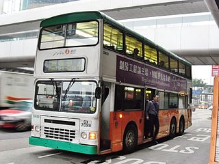
Urban Route No.4 is a circular bus route on Hong Kong Island operated by New World First Bus. It runs between Wah Fu (South) and Central, via Pok Fu Lam Road and Sai Ying Pun.

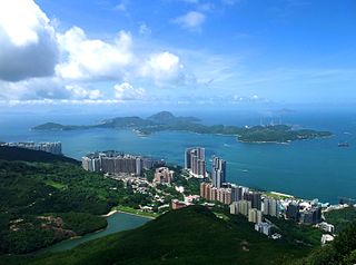
The Central and Western District located on northwestern part of Hong Kong Island is one of the 18 administrative districts of Hong Kong. It had a population of 243,266 in 2016. The district has the most educated residents with the second highest income and the third lowest population due to its relatively small size.

Hong Kong Chinese Christian Churches Union Pok Fu Lam Road Cemetery or Hong Kong Chinese Christian Churches Union Pokfulam Road Cemetery is a cemetery in Pok Fu Lam, Hong Kong. It is managed by The Hong Kong Chinese Christian Churches Union. It lies on the slopes east of Victoria Road between Tung Wah Coffin Home and Pok Fu Lam Road, facing Sandy Bay.

This article highlights the campuses of the University of Hong Kong.


