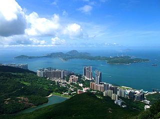
Pok Fu Lam (薄扶林) or Pokfulam is a residential area on Hong Kong Island, at the western end of the Southern District. It is a valley between Victoria Peak and Mount Kellett, around Telegraph Bay.

Shek Tong Tsui or Belcher Point is an area in Sai Wan on Hong Kong Island in Hong Kong. Administratively, it belongs to the Central and Western District.

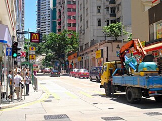
Sai Wan, also known as Western district, or simply Western, is an area in Hong Kong Island, Hong Kong that corresponds to Sai Ying Pun, Shek Tong Tsui, Belcher Bay and Kennedy Town. However, Some Hong Kong people consider Kennedy Town as the only part of Sai Wan. It formed part of the City of Victoria. West Point, a former cape where major government structures in Sai Wan are close to, also used to refer to Sai Wan.

West Point was a point of land on Hong Kong Island, Hong Kong, south of Sulphur Channel. Its location is the shore off Pok Fu Lam Road and Queen's Road West in 1845, approximately the junction of Western Street and Des Voeux Road West near Western Police Station. This was the northernmost point on the western half of Hong Kong Island.

HKU is a station on the Hong Kong MTR Island line located in the Shek Tong Tsui neighbourhood of Western, Hong Kong. The station is named after the adjacent University of Hong Kong.
Sai Ying Pun is an area in Sai Wan, on Hong Kong Island, in Hong Kong. It is administratively part of the Central and Western District.

Victoria Road is a main road near the west shore of Hong Kong Island in Hong Kong connecting Kennedy Town and Wah Fu and an alternative connection of Pok Fu Lam Road. It begins north with Belcher's Street in Kennedy Town and goes along Mount Davis, Sandy Bay, Telegraph Bay and Waterfall Bay and reaches in Kellett Bay.

Bonham Road is a main road in West Mid-Levels, Hong Kong Island in Hong Kong, running mainly East-West. The road connects Pok Fu Lam Road in the west, near the University of Hong Kong, and Caine Road in the east, at the junction with Hospital Road and Seymour Road. It was named after Sir George Bonham, the third Governor of Hong Kong. It was renamed Nishi-Taisho Dori (西大正通) during Japanese occupation of Hong Kong.
Smithfield is a street with a length of approximately 1,300 m in Kennedy Town, Hong Kong Island, Hong Kong. Its northern section is a commercial and residential area, while its southern section is a road connecting it to Pok Fu Lam Road. Smithfield was historically the site of a cattle quarantine depot and a slaughterhouse, and was probably named after its London namesake.
High Street is a one-way street in Sai Ying Pun, Hong Kong, available only to minibuses and private vehicles. It connects Bonham Road in the east and Pok Fu Lam Road in the west. It runs from east to west from Western Street to Pok Fu Lam Road, and from west to east from Western Street to Bonham Road. It was originally named Fourth Street, but because the number four is commonly avoided in Chinese culture, the government changed the name to High Street.

Western Street is an uphill one-way street in Sai Ying Pun, Hong Kong. It connects Bonham Road in the south and Connaught Road West in the north. There are 337 units in 17 buildings in the street. Addresses are odd on the west side of the street, and mostly even on the east side. However, on the newer part of the street, on the reclamation north of Queen's Road West, the east side has both odd and even numbered addresses.
First Street is a street in Sai Ying Pun, an early suburb of Hong Kong.

Third Street, is a street in Sai Ying Pun neighbourhood of Hong Kong. It runs one way from Pok Fu Lam Road, then crosses Water Street, then Pok Fu Lam Road again, then Western Street, Centre Street and terminates at Eastern Street.

Second Street is a street in the Sai Ying Pun area of the Central and Western District on Hong Kong Island, in Hong Kong.
St. Stephen's Church College is a secondary school attached to the Anglican St Stephen's Church in Hong Kong, located between Bonham Road and Pok Fu Lam Road in Sai Ying Pun. The school's total enrollment in the academic year 2009-2010 was approximately 1,000, in 24 classes of two streams, across six forms/grades.
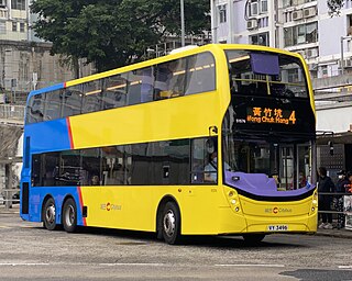
Urban Route No.4 is a bus route on Hong Kong Island operated by Citybus. It runs between Wong Chuk Hang and Central Bus Terminus, via Aberdeen, Wah Fu Estate, Pok Fu Lam Road and Sai Ying Pun.
The Fire Dragon Dance in Pok Fu Lam Village is the main activity during the Mid-Autumn Festival. People hope to beg for peace and be blessed by the gods. It is an important part of the cultural heritage of Hong Kong.

Hong Kong Chinese Christian Churches Union Pok Fu Lam Road Cemetery or Hong Kong Chinese Christian Churches Union Pokfulam Road Cemetery is a cemetery in Pok Fu Lam, Hong Kong. It is managed by The Hong Kong Chinese Christian Churches Union (香港華人基督教聯會). It lies on the slopes east of Victoria Road between Tung Wah Coffin Home and Pok Fu Lam Road, facing Sandy Bay.


