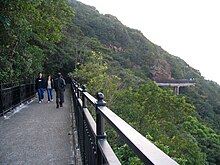
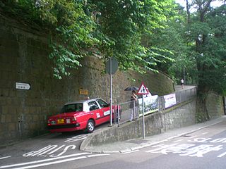
 Lugard Road, elevated section in background | |
| Native name | 盧吉道 (Yue Chinese) |
|---|---|
| Namesake | Sir Frederick Lugard |
| Length | 2,462 metres (8,076 ft) |
| Width | 2.4 metres (8 ft) |
| Location | Victoria Peak, Hong Kong |
| Construction | |
| Construction start | June 1913 |
| Completion | March 1921 |
Description
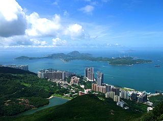
Lugard Road lies approximately 400 m (1,300 ft) above sea level. [1] It is a semi-circular 2.4-kilometre (1.5 mi) road on Victoria Peak that mainly follows the contours of the hillside, connecting Victoria Gap in the east to the Hatton Road-Harlech Road junction in the west. [2] [3] Joining Harlech Road seamlessly at its end, a circuit is formed around The Peak. [2] Lugard Road is the initial section of Stage 1 of the 50-kilometre (31 mi) Hong Kong Trail. [4] [5] Most of Lugard Road enjoys dense tree cover, and a variety of tropical vegetation can be found along its length. [2] The views of the city below from Lugard Road are variously described in travel guides as "stunning" and "spectacular". [1] [3] [6]
The road is approximately 3 metres (9.8 ft) wide at its widest and less than 2 metres (6 ft 7 in) at its narrowest and, while not entirely pedestrian, has vehicular restrictions. [7] [8] Permits to use this road are only issued to residents for access to their properties. [7]
History

The road is named after Sir Frederick Lugard, Governor of Hong Kong from 1907 to 1912. [2] [9]
The Public Works Department issued an invitation for sealed tenders by 2 June 1913 to form a section of roadway from Victoria Gap to High West Gap. [10] The cost of the entire 2,462-metre (8,076 ft) road, whose construction was made difficult by the "rocky and precipitous nature of the hillside", was estimated at HK$55,000. [11] In their 1913 annual report, the PWD noted that HK$11,373 had been spent on the 860-metre (2,820 ft) section completed in the year. [12]
[…] the road will be principally used as a promenade, a wonderful panoramic view of the City, Harbour and surroundings being obtainable from it. Starting from Victoria Gap, the road contours the hillside below the Mount Austin Barracks, being practically level until it reaches a point below Bishop’s Lodge, whence it continues westwards with a rising grade of 1 in 18 to the end of the first section. It is 8 feet in width and is generally cut out of the hillside. In some places, it has been necessary to construct retaining walls in order to avoid excessive cutting or to improve the alignment of the road. [12]
The construction was interrupted by the First World War. [13] The next section built after the war, to join the existing road with Harlech Road, [13] is described having "a minimum width of 8 ft. throughout with a maximum gradient of 1 in 20". [14] It comprises "1,448 lineal feet of reinforced concrete decking and beams carried on 87 cement concrete piers, 1,543 lineal feet of rubble retaining walling and 1,859 lineal feet of hillside benching". [14] In 1920, the Director of Public Works reported that all the substantial pier work for the bridging, rubble retaining walls, cutting and channelling for that section had been completed. The steep terrain made progress slow, and challenges included "numerous dangerous boulders, weighing up to 45 tons each", which had to be removed. [14] By the end of that year, all that still remained to be done was "a small amount of work consisting principally of bridge decking, railings, and road surfacing". [14]
Construction was completed in March 1921, the total project cost being $88,165. [15]
Houses


While the Peak is a prestigious address, there are few houses along Lugard Road. It is not designed for vehicular traffic, as it is too narrow for cars to pass in most places, making the houses close to inaccessible. [16] Furthermore, the escarpments present challenges for construction. There was controversy when planning permission was lodged (and granted) to convert one of the properties along it into a luxury hotel in 2013. [7]
Built heritage
- No. 1 Lugard Road, the Peak Tramways Office built about 1927 as a workshop, with an additional floor added in 1953, now serves as offices for the Peak Tramways Company. It has a highly unusual shape that can best be described as an arrowhead. [17] It was listed as a Grade III historic building in 2010. [18]
- No. 26 Lugard Road. Hong Kong Archive records show that a dwelling was constructed c.1890 on Rural Building Lot 52. The house was sold in 1899 to Joseph Charles Hoare, then Bishop of Victoria, for HK$34,000. The property, thus named "Bishop's Lodge", was owned by Hoare and passed to his wife upon his drowning in a typhoon in 1906. [19] In 1917, the property was sold for $20,830 to Robert Hotung, who surrendered the lease to the Crown in June 1950, a process usually of exchange for other land. [20]
- No. 27 Lugard Road. The oldest house in Lugard Road is a two-storey private residence located at No. 27 designed by Palmer and Turner and constructed in 1914. [16] It was given Grade II historic building status by the Antiquities Advisory Board in September 2013. [21] [22] [23] The neo-classical colonial mansion was designed by Lennox Godfrey Bird and owned by his brother Herbert until it was sold to the Taikoo Dockyard & Engineering Co. in 1930 and used as a residence for their staff. [16] Butterfield & Swire (太古洋行), successor to Taikoo Dockyard, turned the house into a staff mess. [16] In September 2012, the property was acquired for HK$384 million by Ashley Pacific, a company that also owns and runs the Butterfly Hotel and Serviced Apartment Group. The new owners submitted application to the Town Planning Board (TPB) to transform the property into an up-scale boutique hotel. [24] They proposed to expand the 880 square metres (9,500 sq ft) property by building two additional villas of two to three storeys each, making a total of 17 lettable units [23] with a floor area of in excess of 1,100 square metres (12,000 sq ft). [25] Despite stiff objection from local groups and the District Council, the TPB approved the plan. [24] [26]
- No. 28 Lugard Road is a pitched roof bungalow built by Lennox Bird, constructed in 1924. It was owned and occupied by Bird up to the war, after which it was sold. [16]
- No. 35 Lugard Road, Victoria Gap Substation, was built in 1928 by the Hongkong Electric Company to distribute electricity to different populated areas and serve as quarters for its engineers. [27] The 4-storey neo-Georgian building still functions as a staff residence and an electric substation for the locality. The plant is located on the ground floor, while there is a flat on each of the remaining levels. [28] It has been a Grade III historic building since 2010. [18]

See also
Related Research Articles

Hong Kong Island is an island in the southern part of Hong Kong. The island, known originally and on road signs simply as "Hong Kong", had a population of 1,289,500 and a population density of 16,390 per square kilometre (42,400/sq mi), as of 2023. It is the second largest island in Hong Kong, with the largest being Lantau Island. Hong Kong Island forms one of the three areas of Hong Kong, with the other two being Kowloon and the New Territories.

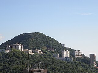
Victoria Peak is a hill on the western half of Hong Kong Island. It is also known as Mount Austin, and locally as The Peak only generally. With an elevation of 552 metres (1,811 ft), it is the tallest hill on Hong Kong Island, and the 29th tallest in the territory of Hong Kong. It is a major tourist attraction offering views of Central, Victoria Harbour, Lamma Island and the surrounding islands.

Repulse Bay or Tsin Shui Wan is a bay in the southern part of Hong Kong Island, located in the Southern District, Hong Kong. It is one of the most expensive residential areas in the world.

The Peak Tram is a funicular railway in Hong Kong, which carries both tourists and residents to the upper levels of Hong Kong Island. Running from Garden Road Admiralty to Victoria Peak via the Mid-Levels, it provides the most direct route and offers good views over the harbour and skyscrapers of Hong Kong. Operated since 1888, it was the first funicular railway in Asia.

Mid-Levels is an affluent residential area on Hong Kong Island in Hong Kong. It is located between Victoria Peak and Central. Residents are predominantly more affluent Hong Kong locals and expatriate professionals.
Pok Fu Lam (薄扶林) or Pokfulam is a residential area on Hong Kong Island, at the western end of the Southern District. It is a valley between Victoria Peak and Mount Kellett, around Telegraph Bay.

Blackhead Point, also known as Tai Pau Mai indigenously, or by the names Tsim Sha Tsui Point and Signal Hill (訊號山), was a cape before any land reclamation took place in Tsim Sha Tsui, Kowloon, Hong Kong. It currently remains a small hill near the coast.
Blue Pool Road is a road linking Happy Valley and Wong Nai Chung Gap on Hong Kong Island, Hong Kong.
Shanghai Street is a 2.3 km long street in the Jordan, Yau Ma Tei and Mong Kok areas of Kowloon, Hong Kong. Completed in 1887 under the name of Station Street (差館街), it was once the most prosperous street in Kowloon. It originates from the south at Austin Road, and terminates in the north at Lai Chi Kok Road. Parallel to Shanghai Street are Nathan Road, Temple Street, Portland Street, Reclamation Street and Canton Road. Though parallel, Shanghai Street was marked by 2- to 3-floor Chinese-style buildings while Nathan Road was marked by Western-style buildings.

Pacific Place is a complex of five office towers, three hotels and one shopping centre situated on Queensway and Henessey Road, Admiralty and Wan Chai, Hong Kong. The latest phase, Six Pacific Place, is located at 50 Queen's Road East, Wan Chai.

High West or Sai Ko Shan, is a mountain on Hong Kong Island with a height of 494 m (1,621 ft)

Pok Fu Lam Country Park is located on Pok Fu Lam, the western end of the Southern District of Hong Kong Island. The 270-hectare park was designated in 1979.

The Old Tai O Police Station is a former police station in Hong Kong. It is located on the small hill next to Tai O Ferry Pier, at the south-western tip of Tai O, which can be considered the most westerly point within Hong Kong.

The Tai Tam Waterworks Heritage Trail is a heritage trail in Hong Kong that comprises 22 waterworks structures with historical value near the Tai Tam group of reservoirs. The Trail is about 5 km long and takes about two hours to complete. The Trail is located along the Tai Tam Reservoir Road with entrance at Wong Nai Chung Gap near Hong Kong Parkview or at the junction of Tai Tam Road and Tai Tam Reservoir Road. Ten information stations were established en route to introduce the functions and historic values of the structures. Guided tours will be organised for schools and non-profit making organisations.

Ho Tung Gardens, also known by its Cantonese name 'Hiu Kok Yuen', was a villa on the Peak, Hong Kong. It was built by Robert Hotung and his wife Clara in 1927. They referred to it as "The Falls", but it later became known as Ho Tung Gardens.

Victoria Gap is an area and a mountain pass located between the summits of Victoria Peak and Mount Gough, on Hong Kong Island, in Hong Kong. It is the most touristic place within the area referred to as The Peak, which receives some seven million visitors every year. Its altitude is 396 metres (1,299 ft) - some 150 metres (490 ft) below the summit of The Peak.

Harlech Road is a road in Hong Kong. It is high up in the Peak area of Hong Kong Island. The road starts at Victoria Gap, then goes along the south slope of Victoria Peak, then crosses High West Gap, and goes along the north slope of High West, and finally ends at the ridge of High West.
Hatton Road, also known as "The Morning Trail", is a paved, steep, motor vehicle-free road in western Hong Kong Island, Hong Kong, on Lung Fu Shan. It is largely used as a fitness trail for walking, running, and cycling.
Mount Kellett is a 501-metre-high (1,644 ft) mountain on Hong Kong Island, Hong Kong. It was likely named after British Royal Navy Vice Admiral Henry Kellett, the captain of HMS Starling in the 19th century.

Peak Road is a road in The Peak on Hong Kong Island, Hong Kong. It is the only road to travel from Victoria Gap to Wan Chai Gap on Hong Kong Island. The Peak Road is a two-lane two-way traffic, which can take buses, minibuses and other vehicles. The highest altitude is about 420 meters.
References
- 1 2 3 England, Vaudine (4 July 2012). "Top 10 walks in Hong Kong". The Guardian.
- 1 2 3 4 Wordie, Jason (2002) "Lugard Road". Streets – Exploring Hong Kong Island. Hong Kong University Press, pp. 91–97. Archived from the original on 29 May 2009.
- 1 2 "Victoria Peak and the Victoria Peak Tram Review ". Fodors. Archived from the original on 6 June 2013.
- ↑ "Pokfulam Country Park" Archived 24 August 2006 at the Wayback Machine . Agriculture, Fisheries and Conservation Dept., Hong Kong
- ↑ Hong Kong Trail: Stage 1, the Peak to Pokfulam Reservoir
- ↑ "Peak Circle Walk". Discover Hong Kong. Archived from the original on 8 August 2013.
- 1 2 3 "LCQ5: Traffic on Lugard Road". Government of Hong Kong. 25 June 2014
- ↑ "Lugard Rd to be restricted". Government of Hong Kong. 25 June 2014
- ↑ "22nd October, 1914", Legislative Council of Hong Kong. p 119. (1914). Archived by University of Hong Kong
- ↑ "No S143". pg 203. University of Hong Kong archives.
- ↑ "9th October 1913", Legislative Council of Hong Kong. pp74-75. (1913) Archived by University of Hong Kong
- 1 2 "#107 Roads and Streets". Report of the Director of Public Works for the year 1913. p. P55, archived by University of Hong Kong.
- 1 2 Lugard Road History, Gwulo
- 1 2 3 4
- 101(c) "Roads: Lugard Road Extension". Report of the Director of Public Works for the year 1920. p. Q42, archived by University of Hong Kong.
- ↑
- 101(a) "Roads: Lugard Road Extension". Report of the Director of Public Works for the year 1921. p. Q49, archived by University of Hong Kong.
- 1 2 3 4 5 "N18: No. 27 Lugard Road" Archived 5 March 2016 at the Wayback Machine . Historic Building Appraisal. Leisure and Cultural Services Dept (June 2013)
- ↑ Brief Information on Proposed Grade 3 Items, Item #886 Archived 21 March 2012 at the Wayback Machine .
- 1 2 List of the Historic Buildings in Building Assessment (@ 21 September 2012) Archived 15 December 2011 at the Wayback Machine
- ↑ "Letters to 'Ted' (Joseph Edward Hoare)" (PDF). p. 2. Retrieved 12 May 2018.
- ↑ Wilson, Anita (9 September 1986). "26 Lugard Road: Rural Building Lot (RBL) 52 Garden Lot (GL) 17". Government Records Office, Hong Kong.
- ↑ Antiquities Advisory Board: List of new items and new categories with assessment results (as at 4 March 2014) Archived 15 November 2017 at the Wayback Machine
- ↑ Chan, Yannie (16 September 2013). "Historic Villa to Become a Heritage Boutique Hotel". HK Magazine. Archived from the original on 26 August 2014.
- 1 2 Chiu, Karen. "Suites at a price". The Standard.
- 1 2 Sell, George (7 September 2013). "Residence on The Peak to become Hong Kong boutique hotel". Boutique Hotel News. Archived from the original on 26 October 2014.
- ↑ "盧吉道27號建酒店獲城規通過". Sing Tao Daily, 7 September 2013. Archived from the original on 26 August 2014.
- ↑ Nip, Amy (26 June 2014). "Lugard Road hotel plan faces more legwork". South China Morning Post
- ↑ Brief Information 1444 Historic Buildings, Item #888 Archived 4 March 2016 at the Wayback Machine (21 September 2012).
- ↑ Brief Information on Proposed Grade 3 Items, Item #888 Archived 21 March 2012 at the Wayback Machine .
External links
- "No. 27 Lugard Road". Historic Building Appraisal, Leisure and Cultural Services Dept. p. N18
| Lugard Road | |||||||||||
|---|---|---|---|---|---|---|---|---|---|---|---|
| Traditional Chinese | 盧吉道 | ||||||||||
| |||||||||||