 | |
| Native name | 怡和街 (Yue Chinese) |
|---|---|
| Former name(s) | Kasuga-dori (1942–1945, during Japanese occupation) |
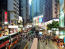
| Length | 300 metres (980 ft) |
| Width | 2 lanes of traffic eastbound, 1 lane westbound |
| Location | Causeway Bay, Hong Kong |
| Coordinates | 22°16′47″N114°11′10″E / 22.2798°N 114.1860°E |
| Construction | |
| Inauguration | 1902 |
- ↑ "Departures from 怡和街 Yee Wo Street". Citymapper. Retrieved 2024-11-26.
- ↑ "Hong Kong TramOramic Tour | Hong Kong Tourism Board". Discover Hong Kong. Retrieved 2024-11-26.
- ↑ Proposed lift installation of footbridge No. HF85 at the junction of Yee Wo Street, Pennington Street and Sugar Street in Wan Chai District (PDF).
- 1 2 "Parklane". wondertrails.parklane.com.hk. Retrieved 2024-11-26.
- ↑ "Causeway Round Pedestrian Bridge". Arch We Love To Hate. Retrieved 2024-11-26.
- ↑ "Yee Wo Street Footbridge (Wan Chai)". Structurae. Retrieved 2024-11-26.
- ↑ "香港銅鑼灣怡和街鋪搶手 意向價1.1億元". Archived 2007-09-27 at the Wayback Machine
- ↑ "McDonald's Building Doctor List - 18 Doctors". FindDoc. Retrieved 2024-11-26.
- ↑ "Photos of East Point - Jardine Matheson - ML52 [????- ] | Gwulo". gwulo.com. Retrieved 2024-11-26.
- ↑ "Our History". Jardine Matheson. Retrieved 2024-11-26.
- ↑ Chan, Chan, Ka-leung (2011). Witness of history: a case study of street signs at Pei Ho Street as an important urban heritage in Hong Kong (Master of Science in Conservation thesis). University of Hong Kong. p. 31.
{{cite thesis}}: CS1 maint: multiple names: authors list (link)
| Yee Wo Street | |||||||||||
|---|---|---|---|---|---|---|---|---|---|---|---|
| Chinese | 怡和街 | ||||||||||
| |||||||||||