Wan Chai is located in the western part of Wan Chai District on the northern shore of Hong Kong Island, Hong Kong. It is bounded by Canal Road to the east, Arsenal Street to the west, and Bowen Road to the south. The area north of Gloucester Road is often called Wan Chai North.

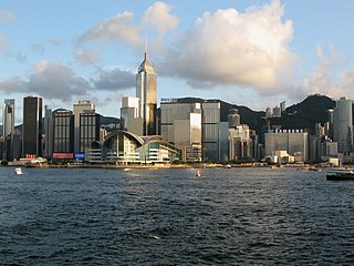
Central, also known as Central District, is the central business district of Hong Kong. It is located in the northeastern corner of the Central and Western District, on the north shore of Hong Kong Island, across Victoria Harbour from Tsim Sha Tsui, the southernmost point of Kowloon Peninsula. The area was the heart of Victoria City, although that name is rarely used today.

SoHo is an area of Hong Kong located on the western edge of Central, bordering Sheung Wan, known for its bars, restaurants and entertainment venues. The name is derived from its location: South of Hollywood Road.

Mid-Levels is an affluent residential area on Hong Kong Island in Hong Kong. It is located between Victoria Peak and Central. Residents are predominantly more affluent Hong Kong locals and expatriate professionals.

Sheung Wan is an area in Hong Kong, located in the north-west of Hong Kong Island, between Central and Sai Ying Pun. Administratively, it is part of the Central and Western District. The name can be variously interpreted as Upper District, or Gateway District.

The former Central Police Station of Hong Kong is located at the eastern end of Hollywood Road, in Central, Hong Kong. It has been redeveloped into a cultural and shopping destination generally called Tai Kwun (大館). Tai Kwun is composed of three declared monuments: the former Central Police Station, former Central Magistracy and Victoria Prison.

Sai Wan, also known as Western district, or simply Western, is an area in Hong Kong Island, Hong Kong that corresponds to Sai Ying Pun, Shek Tong Tsui, Belcher Bay and Kennedy Town. However, Some Hong Kong people consider Kennedy Town as the only part of Sai Wan. It formed part of the City of Victoria. West Point, a former cape where major government structures in Sai Wan are close to, also used to refer to Sai Wan.
Sai Ying Pun is an area in Sai Wan, on Hong Kong Island, in Hong Kong. It is administratively part of the Central and Western District.

Western Market is one of the oldest structures in Sheung Wan, Hong Kong Island, Hong Kong. The current structure, built in 1906, was the North Block of the original Western Market. It is the oldest surviving market building in the city. The former South Block was demolished in 1981 and its site is now occupied by the Sheung Wan Complex.

Ladder Street is a street in the Central and Western District of Hong Kong, consisting entirely of steps and landings formed by granite slabs or concrete paving. It was so named because it extends straight up and down like a ladder. The street has been listed as a Grade I historic building.

Old Bailey Street is located in Central, Hong Kong. The name is derived from the Old Bailey, the Central Criminal Court in central London, United Kingdom.

Queen's Road is a collection of roads along the northern coast of Hong Kong Island, in Hong Kong, within the limit of Victoria City. It was the first road in Hong Kong, constructed by the British between 1841 and 1843, spanning across Victoria City from Shek Tong Tsui to Wan Chai.

Pottinger Street is a street in Central, Hong Kong. It is also known as the Stone Slabs Street since the street is paved unevenly by granite stone steps. It was named in 1858 after Henry Pottinger, the first Governor of Hong Kong, serving from 1843 to 1844. It is a Grade I historic building.

A Man Mo temple, or Man Mo Miu, is a temple dedicated to the Chinese folk god of literature, Man Tai (文帝), or Man Cheong (文昌), and the martial god Mo Tai (武帝), or Kwan Tai (關帝). The two deities were commonly patronized by scholars and students seeking progress in their study or ranking in the civil examinations in the Ming and Qing dynasties. There are several Man Mo temples in Hong Kong, the best-known of which is the one in Sheung Wan.

Aberdeen Street is a border street dividing Sheung Wan and Central on Hong Kong Island, Hong Kong. It ascends from Queen's Road Central to Caine Road in Mid-Levels. The street is named after George Hamilton-Gordon, 4th Earl of Aberdeen, Foreign Secretary at the time of the cession of Hong Kong Island to the United Kingdom in 1842.

Tai Ping Shan Street is a street marking the early colonial history in Hong Kong. Located at the north slope of Victoria Peak in Sheung Wan, the street starts east from a ladder street at the junction with Bridges Street and end west in Po Yan Street near Tung Wah Hospital. The street runs parallel to Hollywood Road.

Pound Lane is a lane in Sheung Wan on Hong Kong Island, Hong Kong.

Hollywood Road Park is an urban public park in Sheung Wan, Hong Kong Island, Hong Kong.
The Central and Western District located on northwestern part of Hong Kong Island is one of the 18 administrative districts of Hong Kong. It had a population of 243,266 in 2016. The district has the most educated residents with the second highest income and the third lowest population due to its relatively small size.
Sheung Chui Court is a home ownership scheme (HOS) court in Sha Tsui Road, Tsuen Wan, New Territories, Hong Kong, which is the first and only HOS court in Tsuen Wan District. It has 3 blocks with total of 962 units. Also, an elderly day care centre is within the court. It was offered for sale to public in December 2014 and is expected to be completed in 2017.


