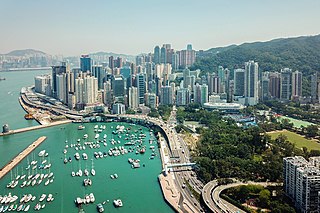
Causeway Bay is an area and a bay on Hong Kong Island, Hong Kong, straddling the border of the Eastern and the Wan Chai districts. It is a major shopping, leisure and cultural centre in Hong Kong, with a number of major shopping centres. The rents in the shopping areas of Causeway Bay were ranked as the world's most expensive for the second year in a row in 2013, after overtaking New York City's Fifth Avenue in 2012. When referring to the area, the Cantonese name is never written in English as "Tung Lo Wan".

Kowloon is an urban area in Hong Kong comprising the Kowloon Peninsula and New Kowloon. With a population of 2,019,533 and a population density of 43,033/km2 (111,450/sq mi) in 2006, it is the most populous area in Hong Kong, compared with Hong Kong Island and the rest of the New Territories. The peninsula's area is about 47 km2 (18 sq mi).

Kwun Tong is an area in the Kwun Tong District of Hong Kong, situated at the eastern part of the Kowloon Peninsula, and its boundary stretches from Lion Rock in the north to Lei Yue Mun in the south, and from the winding paths of Kowloon Peak in the east to the north coast of the former Kai Tak Airport runway in the west.
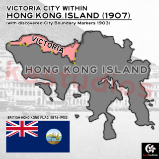
The City of Victoria, often called Victoria City or simply Victoria, was the de facto capital of Hong Kong during its time as a British dependent territory. It was initially named Queenstown but was soon known as Victoria. It was one of the first urban settlements in Hong Kong and its boundaries are recorded in the Laws of Hong Kong. All government bureaux and many key departments still have their head offices located within its limit.

The Hong Kong Museum of Coastal Defence is a museum in Hong Kong, located in a former coastal defence fort overlooking the Lei Yue Mun channel, near Shau Kei Wan on Hong Kong Island. The fort was built by the British in 1887, intended to defend the eastern approaches to Victoria Harbour.

Happy Valley is an upper-income residential area in Hong Kong, located on Hong Kong Island. The area is bordered by Caroline Hill to the east, Jardine's Lookout to the south, Morrison Hill to the west, and Causeway Bay to the north. Administratively, it is part of Wan Chai District.

Kornhill and Kornhill Gardens are apartment buildings on the northern slope of Mount Parker, in Quarry Bay, Hong Kong Island, Hong Kong. Kornhill is a private housing estate and Kornhill Gardens is a Private Sector Participation Scheme estate. The total population is approximately 30,000.

Chai Wan Road located in Hong Kong, is one of the major roads in Chai Wan on Hong Kong Island. It runs from Shau Kei Wan to Chai Wan through Chai Wan Gap; with one of the steepest inclines in Hong Kong on either side, with signs posted 1 in 10 gradient. It is therefore popularly referred to as Cheung Meng Che (長命斜), or long-lived incline.

Hollywood Road is a street in Central and Sheung Wan, on Hong Kong Island, Hong Kong. The street runs between Central and Sheung Wan, with Wyndham Street, Arbuthnot Road, Ladder Street, Upper Lascar Row, and Old Bailey Street in the vicinity.

Canal Road East, Canal Road West (堅拿道西) and the Canal Road Flyover (堅拿道天橋) are important roads in the Wan Chai District of Hong Kong Island, between the areas of East Point near Causeway Bay, and Morrison Hill near Wan Chai.

Yau Tong is an area of Hong Kong, located in the southeastern end of Kowloon, between Lei Yue Mun and Lam Tin, at the east shore of Victoria Harbour, west of Tseung Kwan O. Administratively, it is part of Kwun Tong District, the most densely populated district in Hong Kong.
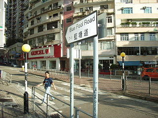
Blue Pool Road is a road linking Happy Valley and Wong Nai Chung Gap on Hong Kong Island, Hong Kong.

Garden Road is a major road on Hong Kong Island, Hong Kong, connecting the Central and Mid-Levels areas. It was formerly known as Albany Nullah.
Stubbs Road is a road located in Mid-Levels East, Central, Hong Kong, which connects Happy Valley to The Peak area on Hong Kong Island, Hong Kong, through an area near the Wong Nai Chung Gap. It runs uphill from Queen's Road East and goes through a residential area of luxurious high-rise tower blocks. The road is named after the 16th Governor of Hong Kong, Sir Reginald Edward Stubbs.

MacDonnell Road is a street in the Mid-Levels area of Hong Kong Island, Hong Kong.

Glenealy is one of the few roads or streets without a suffix in Hong Kong. Located in the Mid-Levels on the Hong Kong Island, Hong Kong, it starts from Ice House Street and goes uphill to Hong Kong Zoological and Botanical Gardens, across Robinson Road and ends at Hornsey Road and Conduit Road.

Wong Nai Chung Gap is a geographic gap in the middle of Hong Kong Island in Hong Kong. The gap is between Mount Nicholson and Jardine's Lookout behind Wong Nai Chung. Five roads meet at the Gap: Wong Nai Chung Gap Road, Tai Tam Reservoir Road, Repulse Bay Road, Deep Water Bay Road and Black's Link. It is a strategic passage between the north and south of the island, though less so today since the opening of the Aberdeen Tunnel.

Johnston Road is a major road in Wan Chai on the Hong Kong Island of Hong Kong.

Mount Nicholson is a 430 m (1,411 ft) tall mountain located in Wan Chai District, on Hong Kong Island, Hong Kong. The hill is believed to be named for Hong Kong Volunteer Corps Adjunct Lieutenant W.C.A. Nicholson.

The Dragon's Back is a mountain ridge in southeastern Hong Kong Island, Hong Kong that passes through Shek O Peak. It lies within the Shek O Country Park. In 2019, the Dragon's Back Trail was selected by CNN as one of the world's 23 best trails. Dragon's Back is part of Stage 8 of the Hong Kong Trail.
