Smithfield, Hong Kong

Last updated

Smithfield
Smithfeild.jpg
North section of Smithfield, looking south.
Length1.38 km (0.86 mi)
1.10 km (0.68 mi) two-way, 0.28 km (0.17 mi) one-way
South end Pok Fu Lam Road / Mount Davis Road
North endNew Praya Kennedy Town / Shing Sai Road

Location

The street begins at New Praya, Kennedy Town (堅彌地城新海旁) [2] at the Victoria Harbour shore of the town, at Belcher Bay, and extends south into Mount Davis. It crosses two of the main streets of Kennedy Town: Catchick Street (吉席街) and Belcher's Street. To the south, Smithfield forms T-shaped intersections with Rock Hill Street (石山街), Forbes Street (科士街), Pokfield Road, Lung Wah Street (龍華街). It ends at a junction with Pok Fu Lam Road and Mount Davis Road (摩星嶺道). [2]

Features

History

Cattle depot

The area bound by the present day Rock Hill Street and Pokfield Path (蒲飛徑) was historically the site of a cattle quarantine depot and a slaughterhouse to house and slaughter live cattle when the animals first arrived in Hong Kong via the piers in Kennedy Town. The Kennedy Town Slaughterhouse was established in 1894. [15] [16]

Smithfield was an area frequented by people who worked as labourers at the cattle station, and the marketplaces nearby that have since become the Forbes Street Temporary Playground (科士街臨時遊樂場) and the North Street (北街) red minibus terminus, and for the loading and unloading of sea cargo coming in and out of the piers of Kennedy Town.

The British novelist Martin Booth wrote in his 2004 autobiographical Gweilo: Memories of a Hong Kong Childhood : "the bellow of a cow in the Kennedy Town abattoir might lift up to me – to be abruptly cut short". [17]

In 1961, the government decided that the slaughterhouse was to be relocated to the Kennedy Town Abattoir at Cadogan Street, [18] and it moved in 1968. [15] Despite calls to convert the original slaughterhouse site into a swimming pool, the government said in 1969 that the plan was not feasible until both the cattle depot and the former slaughterhouse complex (then occupied by the cattle depot as well) were released for redevelopment. [19] The cattle depot was closed down in 1986, when the government finally decided that it was to be removed. [15] [20] The land was subsequently developed into the Kennedy Town Swimming Pool (堅尼地城游泳池, now demolished), Smithfield Market (士美非路街市) and the Smithfield Municipal Services Building. [15]

An abattoir and pig depot existed on the other south west side of Smithfield from the late 19th century until at least 1970. [21]

Air raid tunnel

At the time of the Battle of Hong Kong in 1941, Smithfield was the site of the No. 9 Air Raid Tunnel. [22]

Gasometer

Following the fire at the gasometer in Shek Tong Tsui (formerly known as West Point), the Hong Kong and China Gas Company had by 1936 purchased an area of land situated to the south of the cattle depot and erected a gasometer to replace the former gasometer at West Point. [23] The gasometer was in existence until the early 1980s when it was demolished to make way for the construction of Smithfield Terrace (嘉輝花園) by Henderson Land Development Co. Ltd, the largest shareholder of Hong Kong and China Gas Company.

Municipal Services Building

Smithfield Municipal Services Building was completed in 1995, and was then called "The Urban Council Smithfield Complex". [9] The Smithfield Sports Centre inside the building opened in July 1996. [3] The market within the building opened in June 1996. [24] It is divided into three parts, each occupying a separate floor: meat and wet fish market, fruit and vegetable market, cooked food stalls. These retail outlets were previously located in the surrounding streets of Kennedy Town, [8] including the longstanding Smithfield Road Temporary Market, which was a licensed food market, [25] and illegal hawkers at the junction of Smithfield and Belcher's Street. [15]

Extension

Until the mid-1990s, Smithfield was a dead end street at the top end with Wah Fai House (華輝大廈), Mei Wah Mansion (美華大廈) and Smithfield Garden (士美菲園), which are to the south of the Lung Wah Street junction, marking the end of the street. However, record of the Lands Department shows that Ho Chong (何莊; lit. "Farmstead of the Ho family"), [26] a Hotung ancestral family property [27] [28] situated at the hillside beyond the top end of the street, is given the address of "40A Smithfield" and should thus be treated technically as the original top end of Smithfield.

Later the soil on the hillside behind Wah Fai House and Mei Wah Mansion was removed, and a vehicle link between Smithfield and Pok Fu Lam Road was constructed. The link was opened to vehicles in early 1998 and is now known as Smithfield Extension, to be distinguished from the original top end of the street adjacent to Lung Wah Street.

Name

Smithfield is one of the few streets in Hong Kong without the use of words such as "Road", "Street", "Path", "Lane" etc. [29] Other notable examples are Queensway in Admiralty, Broadway (百老匯街) in Mei Foo and Glenealy in Mid-Levels.

London namesake

Smithfield, Hong Kong, was probably named after its London namesake by the British colonial administration. Smithfield, London, is an area in the north-western part of the City of London with a history of over 800 years. It started as an area to house live cattle from the country before they were slaughtered and sold at the meat markets in the City of London. The area was frequented by people of the grassroots of society who worked there as labourers and traders of meat and other foodstuff in the marketplaces nearby. Though situated in England, Smithfield, London, has been a symbol of Scottish patriotism after William Wallace was executed there in 1305. Smithfield, London, as a landmark was promoted by literary works such as Charles Dickens' Oliver Twist and Mark Twain's The Prince and the Pauper .

The old cattle stations in both Smithfield, London and Smithfield, Hong Kong have ceased to exist and the locations were both replaced by a market. Both areas have since been redeveloped to accommodate middle class residents.

Name change

The street is often mistakenly written as Smithfield Road by local residents, affected by the Chinese suffix (lo, lit. road) and in Chinese, 士美非路 was often mistaken as 士美菲路 too.

On 2 February 2007, the Lands Department proposed to rename Smithfield (士美非路) as Smithfield Road (士美菲路). [2] However, the idea to add the word "Road" was opposed on the ground that the street name was unique in that it was named after and had a similar historical development as Smithfield, London. On 18 October 2007, the Government amended the proposal and announced that only the Chinese name of the street would be changed (from 士美非路 to 士美菲路). [30] The name change became official on 14 December 2007. [31]

Transportation

Construction site of Kennedy Town station of the MTR, on Smithfield in 2014. Block D of Kwun Lung Lau is visible in the background. Entrance and exit C of Kennedy Town Station finished construction (October 2014).JPG
Construction site of Kennedy Town station of the MTR, on Smithfield in 2014. Block D of Kwun Lung Lau is visible in the background.

Smithfield is served by trams, buses and minibuses. The Kennedy Town station of the MTR rapid transit railway opened to the public on 28 December 2014. It is located under Smithfield, the former Kennedy Town Swimming Pool and the Forbes Street Temporary Playground. [32] The station has two exits on Smithfield: "A" on the east side connected to a green minibus terminus, and "C" on the west side next to the playground.

Green minibus routes 12, [33] 13, [34] and 23 [35] use and stop on Smithfield.

A Green Mini Bus terminus is on Smithfield adjacent to the MTR exit A. Routes 58 and 59 were relocated from North Street on 25 December 2014, and route 58M started operating at 7am 29 December 2014. [36] [37] The new terminus includes a stop for GMB route 58A to Aberdeen, Hong Kong. [37]

Bus route 43X used to use Smithfield to move between Pok Fu Lam Road and Kennedy Town. This route has a bus stop named "Kennedy Town Swimming Pool" despite its demolition to make way for the MTR station. It has since been canceled. [38]

In the 1990s, road traffic in Smithfield was considered as "extremely heavy throughout the day", and as a consequence, the vehicular entrance of the 
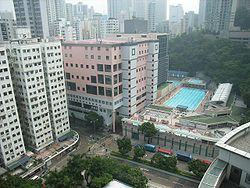
Smithfield Municipal Services Building (completed in 1995) was assigned to the Rock Hill Street. [9] [15]

Intersections

Two-way road section

Southern section of Smithfield (elevated road). HK Smithfield PFLR.JPG
Southern section of Smithfield (elevated road).

Listed from south to north. The entire road is in Kennedy Town, Central and Western District.

Smithfield, Hong Kong
Chinese 士美菲路
km [39] miDestinationsNotes
0.000.00 Pok Fu Lam Road / Mount Davis RoadSouthern terminus
0.800.50Smithfield to Lung Wah Street
0.870.54 Pokfield Road
1.100.68Forbes StreetEnd two-way road
1.000 mi = 1.609 km; 1.000 km = 0.621 mi

One-way road section

Listed from north to south. The entire road is in Kennedy Town, Central and Western District.

km [40] miDestinationsNotes
0.000.00New Praya Kennedy Town / Shing Sai RoadNorthern terminus
0.080.050Catchick Street
0.120.075Hau Wo Street
0.160.099 Belcher's Street
0.230.14Rock Hill Street
0.280.17Forbes StreetEnd one-way road
1.000 mi = 1.609 km; 1.000 km = 0.621 mi

See also

Other places named "Smithfield (disambiguation)"

Related Research Articles

<span class="mw-page-title-main">Hong Kong Tramways</span> Tram system

Hong Kong Tramways (HKT) is a 3 ft 6 in narrow-gauge tram system in Hong Kong. Owned and operated by RATP Dev, the tramway runs on Hong Kong Island between Kennedy Town and Shau Kei Wan, with a branch circulating through Happy Valley.

<span class="mw-page-title-main">Kwun Tong</span> Region in Hong Kong

Kwun Tong is an area in the Kwun Tong District of Hong Kong, situated at the eastern part of the Kowloon Peninsula, and its boundary stretches from Lion Rock in the north to Lei Yue Mun in the south, and from the winding paths of Kowloon Peak in the east to the north coast of the former Kai Tak Airport runway in the west.

<span class="mw-page-title-main">Yau Ma Tei</span> Area in Kowloon Peninsula, Hong Kong

Yau Ma Tei is an area in the Yau Tsim Mong District in the south of the Kowloon Peninsula in Hong Kong.

<span class="mw-page-title-main">Jordan, Hong Kong</span> Suburb in Yau Tsim Mong District, Hong Kong

Jordan is an area in Hong Kong, located on Kowloon Peninsula. It is named after a road of the same name in the district. The area is bordered by King's Park to the east, Tsim Sha Tsui to the south, Ferry Point to the west, and Yau Ma Tei to the north. Administratively, it is part of Yau Tsim Mong District.

<span class="mw-page-title-main">Sheung Wan</span> Area in Hong Kong

Sheung Wan is an area in Hong Kong, located in the north-west of Hong Kong Island, between Central and Sai Ying Pun. Administratively, it is part of the Central and Western District. The name can be variously interpreted as Upper District, or Gateway District.

<span class="mw-page-title-main">Tai Po Market station</span> MTR station in the New Territories, Hong Kong

Tai Po Market is an MTR station on the East Rail line in the New Territories, Hong Kong. Located between Flagstaff Hill and Wan Tau Tong Estate in Tai Po, and adjacent to the eponymous market town, the station has three tracks and four platforms. Platform 1 is for northbound trains to border crossing stations at Lo Wu and Lok Ma Chau and platform 4 is for southbound trains to Admiralty, Kowloon while platforms 2 and 3 use the same track and is reserved for peak hour traffic.

<span class="mw-page-title-main">Kornhill</span> Apartment buildings in Hong Kong

<span class="mw-page-title-main">Quarry Bay</span> Area in Hong Kong

Quarry Bay is an area beneath Mount Parker in the Eastern District of Hong Kong Island, in Hong Kong. Quarry Bay is bordered by Sai Wan Ho to the east, Mount Parker to the south, North Point to the west, and Victoria Harbour to the north.

<span class="mw-page-title-main">Kennedy Town</span> Suburb in Central and Western, Hong Kong, Peoples Republic of China

Kennedy Town is at the western end of Sai Wan on Hong Kong Island in Hong Kong. It was named after Arthur Edward Kennedy, the 7th Governor of Hong Kong from 1872 to 1877. Administratively, it is part of Central and Western District.

<span class="mw-page-title-main">Lam Tin</span> Area in Kowloon, Hong Kong

Lam Tin is an area in the Kwun Tong District in southeastern New Kowloon, Hong Kong. Lam Tin is primarily a residential area but also hosts a major transport interchange and several shopping attractions. Lam Tin was once a large field in the vicinity of Kowloon Bay. During the Song dynasty, it was a site of salt production. Since the 1980s, a number of housing estates were constructed in Lam Tin.

<span class="mw-page-title-main">Sai Ying Pun</span> Area of Western District, Hong Kong

Sai Ying Pun is an area in Western District, on Hong Kong Island, in Hong Kong. It is administratively part of the Central and Western District.

<span class="mw-page-title-main">Jordan Road, Hong Kong</span>

Jordan Road is a road in Jordan, Kowloon, Hong Kong. It spans from the West Kowloon Highway in West Kowloon, through Kwun Chung and Ferry Point to Gascoigne Road and is a major east–west road in southern Kowloon.

<span class="mw-page-title-main">Baguio Villa</span> Housing estate in Pokfulam, Hong Kong

Baguio Villa is a large scale luxury private housing estate located in Pok Fu Lam, Southern District, Hong Kong. It is divided by Victoria Road into Upper Baguio Villa and Lower Baguio Villa.

Articles related to Hong Kong include:

<span class="mw-page-title-main">Citybus Route 1</span> Bus route in Hong Kong

Citybus Route 1 is a bus route operated by Citybus (CTB) on Hong Kong Island, running between Felix Villas and Happy Valley (Upper) via Kennedy Town, Sheung Wan, Central and Wan Chai.

<span class="mw-page-title-main">Sheung Shui Slaughterhouse</span> Slaughterhouse in New Territories, Hong Kong

The Sheung Shui Slaughterhouse is a slaughterhouse in the outskirts of Sheung Shui, New Territories, Hong Kong. The installation was built by China State Construction. Construction began in February 1997, at a cost of HK$ 1.858 billion. It covers 5.8 hectares and is the largest slaughterhouse in Hong Kong, as well as being one of the largest in Asia according to the Architectural Services Department.

<span class="mw-page-title-main">Russell Street, Hong Kong</span> Russell Streets in Hong Kong

Russell Street in Causeway Bay, Hong Kong Island, is a commercial shopping street in Hong Kong. In 2014, it was noted as the most expensive luxury street in the world.

<span class="mw-page-title-main">Citybus Route 5</span> Bus route in Hong Kong

Route 5 is a cancelled bus route on Hong Kong Island operated by Citybus, between Felix Villas (摩星嶺) and Causeway Bay (銅鑼灣威非路道).

<span class="mw-page-title-main">Rail transport in Hong Kong</span> Trains in the Special Administrative Region

Hong Kong's rail network mainly comprises public transport trains operated by the MTR Corporation Limited (MTRC). The MTRC operates the metro network of the territory and the commuter rail network connecting the northeastern, northwestern and southwestern New Territories to the urban areas. The operations of the territory's two leading railway companies, MTRC and the Kowloon-Canton Railway Corporation (KCRC), were merged in 2007 on grounds of economies of scale and cost effectiveness. The Hong Kong Government has an explicit stated transport policy of using railways as its transport backbone.

References

  1. The length of the street is given by the Lands Department in the HKSAR Government Notice 945 of 2007 as 1,380 m, in the HKSAR Government Notice 6812 of 2007 as 1,300 m, and in the HKSAR Government Notice 8290 of 2007 as 1,300 m as well. Therefore, on balance of probabilities, the description of the length of the street is put as 1,300 m
  2. 1 2 3 Lands Department, "Notice of intention to change street name", HKSAR Government Notice 945, 2 February 2007
  3. 1 2 Leisure and Cultural Services Department: Indoor Sports Centres
  4. Food and Environmental Hygiene Department: Smithfield Market
  5. Food and Health Bureau. Food and Environmental Hygiene Department. "Management of public markets", 23 October 2008
  6. Brown, Jules (28 March 2002). The Rough Guide to Hong Kong & Macau. Rough Guides. p. 78. ISBN   978-1-85828-872-7.
  7. Smithfield Public Library website
  8. 1 2 Shelton, Barrie; Karakiewicz, Justyna; Kvan, Thomas (2010). The Making of Hong Kong: From Vertical to Volumetric. Routledge. p. 142. ISBN   978-0-415-48701-6.
  9. 1 2 3 Chan, Pan-hang, Marco (1997). Redevelopment of Macpherson Playground and Queen Elizabeth II Youth Centre (PDF) (Thesis). Department of Architecture, University of Hong Kong. Archived from the original (PDF) on 22 March 2012.{{cite thesis}}: CS1 maint: multiple names: authors list (link)
  10. Sarah Fung, "Eight Great Public Swimming Pools" Archived 12 May 2012 at the Wayback Machine , HK Magazine , retrieved 18 September 2011
  11. Jillian Xin, Natalie Wong, "A guide to Hong Kong's best pools", Time Out Hong Kong, 3 August 2009
  12. Woods, Sarah (2004). Adventures with Kids: The Essential Guide to Hong Kong for the Expat Parent. p. 125. ISBN   978-962-86732-2-3.
  13. Proposed location of Kennedy Town Station, MTR Corporation
  14. Press release: "Kennedy Town Swimming Pool to open for public use", 9 May 2011
  15. 1 2 3 4 5 6 Kwok, Ka-chun, Peter (1995). Remodelling U.C. Complex in Kennedy Town (M Arch thesis). Department of Architecture, University of Hong Kong.{{cite thesis}}: CS1 maint: multiple names: authors list (link)
  16. Official Report of Hong Kong Legislative Council Proceedings, 11 March 1901, page (28), right column, 6th paragraph
  17. Gwulo: Old Hong Kong, "Chapter 8 : Ida, Su Yin, the light of Tin Hau, and the wrath of Yen Lo"
  18. Official Report of Hong Kong Legislative Council Proceedings, 13 December 1961, page 319, 2nd paragraph
  19. Official Report of Hong Kong Legislative Council Proceedings, 4 June 1969, page 312, item 4
  20. Official Report of Hong Kong Legislative Council Proceedings, 23 April 1986, page 1055, 3rd full paragraph
  21. Morgenstern, N. R. (August 2000). "Report on the Kwun Lung Lau Landslide of 23 July 1994" (PDF). Geotechnical Engineering Office. pp. 65, 71–77. Retrieved 20 December 2014.
  22. Banham, Tony (2003). Not the slightest chance: the defence of Hong Kong, 1941. University of British Columbia Press. p. 60. ISBN   978-0-7748-1045-6.
  23. Official Report of Hong Kong Legislative Council Proceedings, 24 June 1936, page 141
  24. Hong Kong 1997: a review of 1996 . Hong Kong. Government Information Services. 1997. p.  167. ISBN   978-962-02-0233-9.
  25. Abbas, Ackbar. Hong Kong: culture and the politics of disappearance. Hong Kong University Press. p. 75. ISBN   978-962-209-433-8.
  26. Gwulo: Old Hong Kong, Chiu Yuen Cemetery (Eurasian)
  27. Royal Asiatic Society Hong Kong Branch Newsletter: "Visit to Chiu Yuen Cemetery, Mount Davis Archived 2 April 2012 at the Wayback Machine ", pp. 4–5, September 2006
  28. Royal Asiatic Society Hong Kong Branch Branch Newsletter: "Visit to Chiu Yuen Cemetery, Pokfulam Archived 2 April 2012 at the Wayback Machine ", p. 6, January 2007
  29. Shirmaine Cheung, "Translation of Short Texts: A case study of street names in Hong Kong", University of Queensland, June 2010.
  30. Lands Department, "Notice of intention to change street name", HKSAR Government Notice 6812, 18 October 2007
  31. Lands Department, "Declaration to change street name", HKSAR Government Notice 8290, 14 December 2007
  32. Site Plan of Kennedy Town Station, West Island Line EIA Reports
  33. "Hong Kong Island GMB Route No. 12". Transport Department. Retrieved 12 December 2014.
  34. "Hong Kong Island GMB Route No. 13". Transport Department. Retrieved 12 December 2014.
  35. "Hong Kong Island GMB Route No. 23". Transport Department. Retrieved 12 December 2014.
  36. AMS, New MTR Feeder Service (in Chinese), AMS
  37. 1 2 "New Transport Facility, New Feeder Services and Fare Concession Arrangements to tie in with the Commissioning of West Island Line". Traffic Notices. Transport Department - The Government of the Hong Kong Special Administrative Region. 22 December 2014. Retrieved 28 December 2014.
  38. "Bus route 43X" . Retrieved 12 December 2014.
  39. OpenStreetMap contributors. Smithfield (Pok Fu Lam Road to Forbes Street) (Map). OpenStreetMap . Retrieved 22 March 2016.
  40. OpenStreetMap contributors. Smithfield (New Praya Kennedy Town to Forbes Street) (Map). OpenStreetMap . Retrieved 22 March 2016.

22°16′50″N114°07′45″E / 22.280535°N 114.129137°E / 22.280535; 114.129137