Lantau Island is the largest island in Hong Kong, located West of Hong Kong Island and the Kowloon Peninsula, and is part of the New Territories. Administratively, most of Lantau Island is part of the Islands District of Hong Kong. A small northeastern portion of the island is located in the Tsuen Wan District.

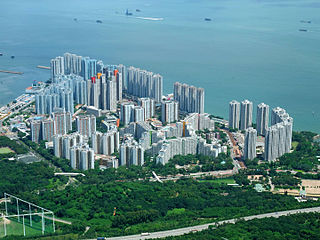
Tung Chung, meaning "eastern stream", is an area on the northwestern coast of Lantau Island, Hong Kong. One of the most recent new towns, it was formerly a rural fishing village beside Tung Chung Bay, and along the delta and lower courses of Tung Chung River and Ma Wan Chung in the north-western coast of Lantau Island. The area was once an important defence stronghold against pirates and foreign military during the Ming and the Qing dynasties.

Ma On Shan Country Park is a park located in the central neck of the Sai Kung Peninsula in the eastern New Territories of Hong Kong. The park covers an area of 28.8 square kilometres (11.1 sq mi) and links Sai Kung Country Park and Lion Rock Country Park to form an extensive recreation area on the Ma On Shan massif.

A BioBlitz, also written without capitals as bioblitz, is an intense period of biological surveying in an attempt to record all the living species within a designated area. Groups of scientists, naturalists and volunteers conduct an intensive field study over a continuous time period. There is a public component to many BioBlitzes, with the goal of getting the public interested in biodiversity. To encourage more public participation, these BioBlitzes are often held in urban parks or nature reserves close to cities. Research into the best practices for a successful BioBlitz has found that collaboration with local natural history museums can improve public participation. As well, BioBlitzes have been shown to be a successful tool in teaching post-secondary students about biodiversity.

The MacLehose Trail is a 100-kilometre hiking trail that crosses much of the New Territories, Hong Kong, starting from Pak Tam Chung, Sai Kung District in the east to Tuen Mun Town, Tuen Mun District in the west. The path is marked by distance posts at 500-metre intervals. The trail is named after Murray MacLehose, Baron MacLehose of Beoch, the longest-serving governor of Hong Kong, who established the Country Parks and was himself an enthusiastic hiker. The trail passes through a variety of natural scenery including beaches and mountains.

High West or Sai Ko Shan, is a mountain on Hong Kong Island with a height of 494 m (1,621 ft)
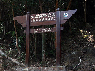
Tai Tam Country Park, also known simply as Quarry Bay Country Park (鰂魚涌郊野公園), on the eastern side of Hong Kong Island, is one of the twenty four statutory country parks in Hong Kong, and the twentieth to be so designated, in 1979. This 270-hectare (670-acre) park is located near Quarry Bay. It covers Mount Parker, the second highest peak on Hong Kong Island, as well as Mount Butler and Siu Ma Shan. Sir Cecil's Ride goes through the park.
Articles related to Hong Kong include:

Several heritage trails have been designed in Hong Kong:
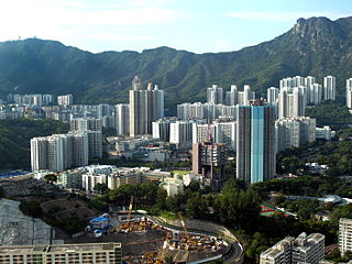
Lok Fu is a place in Wong Tai Sin District, Kowloon, Hong Kong. It is located to the east of Kowloon Tsai, the west of Wong Tai Sin and the north of Kowloon City. It geographically includes nearby Wang Tau Hom.

Pinewood Battery is a historic military site in Hong Kong, located 307 metres (1,007 ft) above sea level, within Lung Fu Shan Country Park, in the northwestern part of Hong Kong Island.
The following is an overview of public housing estates in Tuen Mun, Hong Kong, including Home Ownership Scheme (HOS), Private Sector Participation Scheme (PSPS), Sandwich Class Housing Scheme (SCHS), Flat-for-Sale Scheme (FFSS), Subsidised Sale Flats Project (SSFP), and Tenants Purchase Scheme (TPS) estates.
The following shows the public housing estates in Pok Fu Lam, Aberdeen, Wong Chuk Hang and Ap Lei Chau of Southern District, Hong Kong.

Harlech Road is a road in Hong Kong. It is high up in the Peak area of Hong Kong Island, The road starts at Victoria Gap, then goes along the south slope of Victoria Peak, then crosses High West Gap, and goes along the north slope of High West, and finally ends at the ridge of High West.
Hatton Road, also known as "The Morning Trail", is a paved, steep, motor vehicle-free road in western Hong Kong Island, Hong Kong, on Lung Fu Shan. It is largely used as a fitness trail for walking, running, and cycling.

Lung Fu Shan or Hill Above Belcher's is a 831-foot (253 m) hill on the northwestern part of Hong Kong Island, Hong Kong, and an area on the northeastern slope of the hill where the main campus and centennial campus of the University of Hong Kong are located.