Yuen Long District is one of the districts of Hong Kong. Located in the northwest of the New Territories, it had a population of 662,000 in 2021.
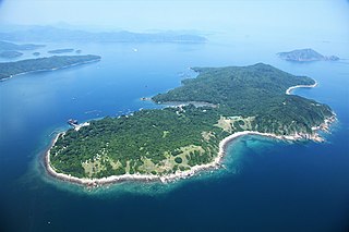
Grass Island or Tap Mun is an island in Hong Kong, located in the northeastern part of the territory. Its area is 1.69 km2 (0.65 sq mi). Administratively, it is part of the Tai Po District. There are about 100 people living on the island, and feral cattle are known on the island.
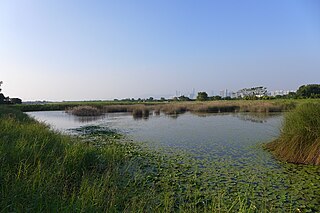
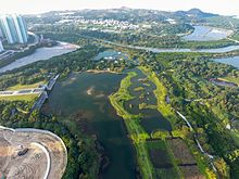
Mai Po Marshes (Chinese: 米埔濕地; Hong Kong Hakka: Mi3bu4 Sip5ti4) is a nature reserve located in San Tin near Yuen Long in Hong Kong. it is within Yuen Long District.

The Light Rail, also known as the Light Rail Transit (LRT), officially the North-West Railway, is a light rail system in Hong Kong, serving the northwestern New Territories, within Tuen Mun District and Yuen Long District. The system operates over 1,435 mmstandard gauge track, using 750 V DC overhead power supply. It was once one of four systems comprising the KCR network in Hong Kong, before the MTR–KCR merger in 2007. It has a daily ridership of about 483,000 people. The line is colour warm yellow on the map, formerly deep orange before the MTR–KCR merger.

Sha Tin, also spelt Shatin, is a neighbourhood along Shing Mun River in the eastern New Territories, Hong Kong. Administratively, it is part of the Sha Tin District. Sha Tin is one of the neighbourhoods of the Sha Tin New Town project.

Lau Fau Shan is an area of Yuen Long District, in the New Territories of Hong Kong. It is at the shore of Deep Bay, near Tin Shui Wai and facing Shekou in Shenzhen, China.

Shap Pat Heung is an area in the New Territories of Hong Kong. Located south of Yuen Long and northeast of Tai Tong, the area occupies the plain north of hills of Tai Lam. The Cantonese name 'Shap Pat Heung' means 'eighteen villages' at its beginning. It was later expanded to thirty villages. Administratively, it is part of the Yuen Long District.

Ta Kwu Ling is an area in the North District, New Territories, Hong Kong, located northeast of Sheung Shui, close to the border with mainland China and south to Liantang Subdistrict in Shenzhen.
Kau Pui Lung, formerly Kau Pui Loong or Hau Pui Loong, is a valley and area between Ma Tau Wai and To Kwa Wan, and west of Ma Tau Chung in Kowloon of Hong Kong. The area now full of schools near the junction of Kau Pui Lung Road and Tin Kwong Road, as well as along Farm Road, where Heep Yunn School is located.

Tin Shui Wai New Town is a satellite town in the northwestern New Territories of Hong Kong. Originally a gei wai (基圍) fish pond area, it was developed in the 1980s as the second new town in Yuen Long District and the eighth in Hong Kong. It is 25 kilometres (16 mi) due northwest of Central, the main business area in the territory, on land reclaimed from low-lying areas south of Deep Bay, next to Ping Shan. The population was 292,000 in 2014, while the total projected population for when the town is fully built-out is about 306,000.

Pui O, formerly Lo Pui O (螺杯澳), is an area on Lantau Island in Hong Kong. It is a popular destination for holiday camping in Hong Kong. Visitors may also rent village houses for leisure. Located in the South Lantau, there are four main villages in Pui O, they are Lo Wai (老圍), San Wai (新圍), Lo Uk (羅屋), and Ham Tin (鹹田). Pui O is located at the edge of Lantau South Country Park.

Nam Sang Wai is a wetland area in San Tin, New Territories, Hong Kong to the north of Yuen Long. It is considered ecologically important, and serves as a stopping place for migratory birds. It is also a popular recreational destination, especially on weekends.

Tin Hau temples in Hong Kong are dedicated to Tin Hau (Mazu). Over 100 temples are dedicated to Tin Hau in Hong Kong. A list of these temples can be found below.

Route 705 and Route 706 are Light Rail loop services of the MTR system in Tin Shui Wai in the northwestern New Territories, Hong Kong. Route 705 operates in an anticlockwise direction, and commenced service on 22 August 2004. Route 706 serves the clockwise direction, and began running on 9 April 2004. The two routes are marked as Tin Shui Wai Circular on station signage.

Grandeur Terrace is a public housing estate in Tin Shui Wai, New Territories, Hong Kong, near Hong Kong Wetland Park as well as Light Rail Tin Heng and Wetland Park stop. It is the only estate in Tin Shui Wai which its name does not have the prefix "Tin" and was a HOS and PSPS court, and it is the largest PSPS in Hong Kong with 4,100 residential units. It was jointly developed by Hong Kong Housing Authority and Rich Score Development Ltd, a wholly owned subsidiary of Chun Wo Holdings Limited and it consists of eleven residential buildings completed in 2003. When it was completed, the estate was transferred to public rental housing.

Tin Shui Estate is a public housing estate in Tin Shui Wai, New Territories, Hong Kong, near Tin Shui Wai Hospital, Tin Shui Wai Park and Light Rail Tin Shui stop. It is the second public housing estate in Tin Shui Wai New Town. It is divided into Tin Shui (I) Estate and Tin Shui (II) Estate, and consists of 12 residential buildings completed in 1993.

Tin Chung Court is a Home Ownership Scheme court developed by the Hong Kong Housing Authority in Tin Shui Wai, New Territories, Hong Kong, near Tin Wah Estate, Light Rail Chestwood stop and Tin Shui Wai Park. It comprises 15 residential blocks completed in 1999 and 2002 respectively.
This is a list of public housing estates (including Private Sector Participation Scheme, Home Ownership Scheme and Tenants' Purchase Scheme in Tin Shui Wai New Town, Hong Kong.

Wu Kau Tang is an area in Northeast New Territories, Hong Kong. It is administratively part of North District and is enclosed by Plover Cove Country Park on all sides. It is the starting point of the Wu Kau Tang Country Trail and the Plover Cove Reservoir Country Trail.