Typhoon Hato

Last updated

Map key
  Tropical depression (≤38 mph, ≤62 km/h)
  Tropical storm (39–73 mph, 63–118 km/h)
  Category 1 (74–95 mph, 119–153 km/h)
  Category 2 (96–110 mph, 154–177 km/h)
  Category 3 (111–129 mph, 178–208 km/h)
  Category 4 (130–156 mph, 209–251 km/h)
  Category 5 (≥157 mph, ≥252 km/h)
  Unknown
Storm type
Disc Plain black.svg Tropical cyclone
Solid black.svg Subtropical cyclone
ArrowUp.svg Extratropical cyclone, remnant low, tropical disturbance, or monsoon depression

During the late hours of 18 August, the Joint Typhoon Warning Center (JTWC) started to monitor a tropical disturbance that had developed about 1,495 km (930 mi) southeast of Taipei, Taiwan. [2] By 19 August, the Japan Meteorological Agency (JMA) began to monitor the area of low-pressure as a tropical depression. [3] Around the same time, the JTWC issued a Tropical Cyclone Formation Alert (TCFA), [4] while the JMA initiated advisories as it was determined that the system had 10-minute sustained winds of 55 km/h (35 mph). [5] By 03:00 UTC on 20 August, the JTWC began issuing advisories, designating the system as a tropical depression with the numerical designation of 15W. [6] The PAGASA named 15W as Isang, as system was already a tropical cyclone and was located within their area of responsibility. [7] Six hours later, the JMA upgraded the system to a tropical storm, assigning the name Hato. [8]

At 15:00 UTC of 20 August, the JTWC upgraded Hato to a tropical storm after the storm further organized. [9] By this time, Hato was located in a favorable environment with low vertical wind shear and sea-surface temperatures (SSTs) of 30 °C (86 °F). [10] Hato failed to strengthen throughout most of 21 August due to a partially exposed low-level circulation center (LLCC) with sheared convection. [11] Several hours later, the system's LLCC became broad as convection began to develop. [12] By 22 August, SSTs near the storm rose to 31 °C (87.8 °F), [13] therefore the JMA had upgraded Hato to a severe tropical storm. [14] The system had rapidly consolidated as it formed a 20-nm diameter eye, including a significant improved convective structure with tightly curved banding flowing into the systems LLCC. [15] Both agencies upgraded Hato to a typhoon six hours later, [16] despite its eye losing its structure. [17]

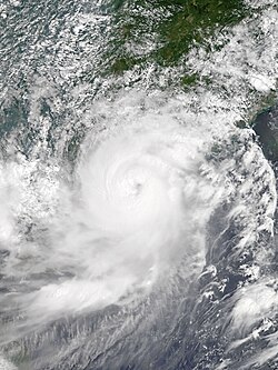
Early on 23 August, the JTWC upgraded Hato to a Category 2 typhoon after its eye began to reform with a central dense overcast. [18] Hato reached its peak intensity as a Category 3-equivalent typhoon with Dvorak estimates reaching T5.5. [2] The JMA estimated peak 10-minute sustained winds of 150 km/h (90 mph) with a minimum barometric pressure of 960 hPa, which was revised to 140 km/h and 965 hPa during post-analysis. [19] However, a minimum pressure of 945 hPa was recorded in Macau, and the CMA estimated a minimum pressure of 935 hPa, suggesting that its intensity was higher. [20] Hato made landfall over the southern coast of Zhuhai, Guangdong at 12:50 CST (04:50 UTC). [21] About three hours later, the JTWC issued its final warning on Hato as the storm moved further inland. [22] Six hours later, the JMA downgraded Hato to a severe tropical storm, [23] then to a tropical storm. [24] The JMA continued to track Hato until 06:00 UTC on 24 August. [25]

Impact

Typhoon Hato (Isang)
Hato 2017-08-23 0250Z.jpg
Typhoon Hato at peak intensity near Macau on 23 August
Deaths and damage from Typhoon Hato
Country/regionFatalitiesDamage
(2017 USD)
Ref
DeathInjured
Mainland China 11523 [26] [27]
Hong Kong 0129 [28] [29] [30]
Macau 10244 [31] [32]
Vietnam 11 [33]
Totals:24845

China

A storm surge of 500–1,300 mm (20–51 in) from the Pearl River inundated the provinces of Guangdong, Guangxi, Yunnan, Fujian and Guizhou. [27] Peak winds of 66.9 m/s (241 km/h) were observed in the city of Guishan, Zhuhai, the strongest wind ever recorded there. [27] 267 people were hurt and sent to hospital, including 10 people who sustained serious injuries. [27] 256 members of the public were stranded and had to be rescued. [27] In total, 32 people were killed while total damages in Mainland China were counted to CN¥28.91 billion (US$4.34 billion). [34]

Hong Kong

Typhoon Hato making landfall over Jinwan, Zhuhai on August 23 Hato RB at landfall.gif
Typhoon Hato making landfall over Jinwan, Zhuhai on August 23

For the first time in five years, since Typhoon Vicente in 2012, the Hong Kong Observatory issued the Hurricane Signal, No.10, which is the highest level of tropical cyclone warning signals in Hong Kong. [35] Owing to the typhoon, the Hong Kong Observatory recorded a record-breaking temperature of 36.6 °C (97.9 °F). It is the highest record in 132 years. [36] The Air Quality Health Index has also reached level 8 in a lot of Air Quality Monitoring Stations. [37] Consequently, Hong Kong saw the closure of businesses, government offices, schools, courts and the stock market. At least 121 cases of injury were reported due to the passage of the storm. [29] Major damage to property, such as broken windows and collapsed scaffolding, were widely reported, with more than 692 reports of fallen trees, debris, displaced bins, and glass shards littering the pavements and major roads. [38] Serious flooding were reported in low-lying areas, such as Heng Fa Chuen on Hong Kong Island, Lei Yue Mun and Tai O due to storm surge. [39] More than 450 flights were cancelled or delayed at Hong Kong International Airport and public transport was brought to a standstill. [40] The estimated economic cost was around HK$4 billion (US$511 million). [28]

Macau

Street flooding in Macau Typhoon-Hato-in-Macao 20170823-145904.jpg
Street flooding in Macau

The storm was the strongest to have hit Macau in 53 years, according to Macau's Chief Executive Fernando Chui, and it was the first time in 18 years that the Macao Meteorological and Geophysical Bureau hoisted a No. 10 tropical cyclone signal. [41] Maximum hourly mean winds of 132 km/h (82 mph) and gusts of 217 km/h (135 mph) were the highest on record in Macau. [42] Most areas of the territory was hit by major flooding and property damages, with citywide power and water outage lasting for at least 24 hours after the passage of the storm. Overall, 10 deaths and at least 200 injuries were reported. [32] The head of the Macao Meteorological and Geophysical Bureau resigned due to criticisms by the Macanese public that officials failed to predict the ferocity of the storm. The Corruption Agency is investigating The Meteorology Bureau's forecasting procedures and management, including the former director Fong Soi-Kun. [43] The Macau SAR Government also announced 1.3 billion Macanese patacas would be set aside for those affected by the typhoon, with families of victims to get up to 300,000 patacas (US$37 thousand) each. [44] In total, Macau suffered an economic loss of 12.55 billion patacas (US$1.56 billion). [31]

There were shortages of basic supplies locally due to residents buying up remaining stocks in response to the utilities shortages and flooding. [45] At the request of the local government, the Chinese People's Liberation Army Macau Garrison was deployed to assist in disaster relief and cleaning up for the first time in Macau history. [46] About 1,000 troops were called in to help remove debris and clear roads.[ citation needed ] Macau police arrested two people for using phone to spread unverified information alleging that the authorities had sought to cover up the discovery of bodies in a car park during Typhoon Hato. [47]

A typhoon and storm surge coupling model demonstrated that the maximum storm surge height reached nearly 2.5 m (8.2 ft) along the coast of Macau, while that in Hong Kong was slightly below 2 m (6.6 ft). Furthermore, a field survey of urban flooding revealed evidence of a 2.25-m inundation in downtown Macau and a 0.55-m inundation on Lantau Island, Hong Kong, which were likely exacerbated by a combination of storm surge, heavy rainfall, and surface water runoff over a complex hilly terrain. [1]

Vietnam

Despite passing well to the north of Vietnam, the storm triggered heavy rainfall and a tornado in Lào Cai, Vietnam on 23 August. More than 754 houses were damaged in Sa Pa, which injured one person. [48] Strong winds damaged about 90 ha (220 acres) of rice crops which included 37 ha (91 acres) of corn. [48] [49] The storm killed one person and total damage reached 7 billion (US$308 thousand). [48] Total damage in Vietnam from the remnants of Hato reached 31 billion₫ (US$1.36 million). [33]

Retirement

Due to the extensive damage and high death toll in South China, the name Hato was officially retired during the 50th annual session of the ESCAP/WMO Typhoon Committee in February 2018. In February 2019, the Typhoon Committee subsequently chose Yamaneko as its replacement name. [50]

See also

Notes

  1. The name Hato was contributed by Japan and means Pigeon or the Japanese constellation for Columba.

Related Research Articles

<span class="mw-page-title-main">Typhoon Neoguri (2008)</span> Pacific typhoon in 2008

Typhoon Neoguri, known in the Philippines as Typhoon Ambo, was the earliest tropical cyclone on record to strike China. The first named storm in the 2008 Pacific typhoon season, named after the Korean word for raccoon dog, it formed from a low pressure area on April 13 to the east of the Philippine island of Mindanao, and after crossing the island it intensified into a tropical storm in the South China Sea. Environmental conditions allowed for quick strengthening, with Neoguri attaining typhoon status on April 16. The typhoon reached its peak intensity on April 18 as it approached the island of Hainan, and subsequently it turned northward. Due to increased wind shear and cooler waters, Neoguri rapidly weakened and made landfall as a minimal tropical storm in southern China on April 19.

<span class="mw-page-title-main">2012 Pacific typhoon season</span> Typhoon season in the Western Pacific Ocean

The 2012 Pacific typhoon season was a slightly above average season that produced 25 named storms, fourteen typhoons, and four intense typhoons. It was a destructive and the second consecutive year to be the deadliest season. It was an event in the annual cycle of tropical cyclone formation, in which tropical cyclones form in the western Pacific Ocean. The season ran throughout 2012, though most tropical cyclones typically develop between May and October. The season's first named storm, Pakhar, developed on March 28, while the season's last named storm, Wukong, dissipated on December 29. The season's first typhoon, Guchol, reached typhoon status on June 15, and became the first super typhoon of the year on June 17.

<span class="mw-page-title-main">2013 Pacific typhoon season</span> Typhoon season in the Western Pacific Ocean

The 2013 Pacific typhoon season was the most active Pacific typhoon season since 2004, and the deadliest since 1975. It featured Typhoon Haiyan, one of the most powerful storms and one of the strongest landfalling tropical cyclones in history. It was an above-average season with 31 named storms, 13 typhoons, and five super typhoons. The season's first named storm, Sonamu, developed on January 4 while the season's last named storm, Podul, dissipated on November 15. Despite the activity, most of the first seventeen named storms before mid-September were relatively weak, as only two of them reached typhoon intensity. Total damage amounted to at least $26.41 billion (USD), making it at the time the costliest Pacific typhoon season on record; it is currently the third costliest, behind the 2018 and 2019 seasons.

<span class="mw-page-title-main">2014 Pacific typhoon season</span> Typhoon season in the Western Pacific Ocean

The 2014 Pacific typhoon season was a slightly below average season, featuring 23 tropical storms, 11 typhoons, 8 super typhoons, and 7 Category 5 typhoons. The season's peak months August and September saw minimal activity caused by an unusually strong and a persistent suppressing phase of the Madden–Julian oscillation (MJO). The season ran throughout 2014, though most tropical cyclones typically develop between May and October. The season began with the development of Tropical Storm Lingling on January 18, and ended after Tropical Storm Jangmi which dissipated on January 1 of the next year.

<span class="mw-page-title-main">2015 Pacific typhoon season</span> Typhoon season in the Western Pacific Ocean

The 2015 Pacific typhoon season was a slightly above average season that produced 27 tropical storms, 18 typhoons, and nine super typhoons. The season ran throughout 2015, though most tropical cyclones typically develop between May and November. The season's first named storm, Mekkhala, developed on January 15, while the season's last named storm, Melor, dissipated on December 17. The season saw at least one named tropical system forming in each of every month, the first time since 1965. Similar to the previous season, this season saw a high number of super typhoons. Accumulated cyclone energy (ACE) during 2015 was extremely high, the third highest since 1970, and the 2015 ACE has been attributed in part to anthropogenic warming.

<span class="mw-page-title-main">2016 Pacific typhoon season</span> Typhoon season in the Western Pacific Ocean

The 2016 Pacific typhoon season is considered to have been the fourth-latest start for a Pacific typhoon season since reliable records began. It was an average season, with a total of 26 named storms, 13 typhoons, and six super typhoons. The season ran throughout 2016, though typically most tropical cyclones develop between May and October. The season's first named storm, Nepartak, developed on July 3, while the season's last named storm, Nock-ten, dissipated on December 28.

<span class="mw-page-title-main">2017 Pacific typhoon season</span> Typhoon season in the Western Pacific Ocean

The 2017 Pacific typhoon season was a below-average season in terms of accumulated cyclone energy and the number of typhoons and super typhoons, and the first since the 1977 season to not produce a Category 5-equivalent typhoon on the Saffir–Simpson scale. The season produced a total of 27 named storms, 11 typhoons, and only two super typhoons, making it an average season in terms of storm numbers. It was an event in the annual cycle of tropical cyclone formation, in which tropical cyclones form in the western Pacific Ocean. The season runs throughout 2017, though most tropical cyclones typically develop between May and October. The season's first named storm, Muifa, developed on April 25, while the season's last named storm, Tembin, dissipated on December 26. This season also featured the latest occurrence of the first typhoon of the year since 1998, with Noru reaching this intensity on July 23.

<span class="mw-page-title-main">2018 Pacific typhoon season</span> Typhoon season in the Western Pacific Ocean

The 2018 Pacific typhoon season was at the time, the costliest Pacific typhoon season on record, until the record was beaten by the following year. The season was well above-average, producing 29 storms, 13 typhoons, and 7 super typhoons. It was an event in the annual cycle of tropical cyclone formation, in which tropical cyclones form in the western Pacific Ocean. The season ran throughout 2018, though most tropical cyclones typically develop between May and October. The season's first named storm, Bolaven, developed on January 3, while the season's last named storm, Man-yi, dissipated on November 28. The season's first typhoon, Jelawat, reached typhoon status on March 29, and became the first super typhoon of the year on the next day.

<span class="mw-page-title-main">Typhoon Usagi (2013)</span> Pacific typhoon in 2013

Typhoon Usagi, known in the Philippines as Super Typhoon Odette, was a violent tropical cyclone which affected Taiwan, the Philippines, China, and Hong Kong in September 2013. Usagi, or which means the constellation Lepus in Japanese, was the fourth typhoon and the nineteenth tropical storm in the basin. Developing into a tropical storm east of the Philippines late on September 16, Usagi began explosive intensification on September 19 and ultimately became a violent and large typhoon. Afterwards, the system weakened slowly, crossed the Bashi Channel on September 21, and made landfall over Guangdong, China on September 22.

<span class="mw-page-title-main">Timeline of the 2012 Pacific typhoon season</span>

This timeline documents all of the events of the 2012 Pacific typhoon season, the period that tropical cyclones formed in the Western Pacific Ocean during 2012. Most of these tropical cyclones formed between May and November 2012. The scope of this article is limited to the Pacific Ocean, north of the equator between 100°E and the International Date Line. Tropical storms that form in the entire Western Pacific basin are assigned a name by the Japan Meteorological Agency (JMA). Tropical depressions that form in this basin are given a number with a "W" suffix by the United States' Joint Typhoon Warning Center (JTWC). In addition, the Philippine Atmospheric, Geophysical and Astronomical Services Administration (PAGASA) assigns names to tropical cyclones that enter or form in the Philippine area of responsibility. These names, however, are not in common use outside of the Philippines.

<span class="mw-page-title-main">Timeline of the 2015 Pacific typhoon season</span>

This timeline documents all of the events of the 2015 Pacific typhoon season. Most of the tropical cyclones formed between May and November. The scope of this article is limited to the Pacific Ocean, north of the equator between 100°E and the International Date Line. This area, called the Western Pacific basin, is the responsibility of the Japanese Meteorological Agency (JMA). They host and operate the Regional Specialized Meteorological Center (RSMC), located in Tokyo. The Japanese Meteorological Agency (JMA) is also responsible for assigning names to all tropical storms that are formed within the basin. However, any storm that enters or forms in the Philippine Area of Responsibility (PAR) will be named by the Philippine Atmospheric, Geophysical and Astronomical Services Administration (PAGASA) using a local name. Also of note - the Western Pacific basin is monitored by the United States' Joint Typhoon Warning Center (JTWC), which gives all Tropical depressions a number with a "W" suffix.

<span class="mw-page-title-main">Tropical Storm Kujira (2015)</span> 2015 Pacific tropical storm

Tropical Storm Kujira was a tropical cyclone that prompted the PAGASA to declare the beginning of the rainy season in the Philippines. The ninth tropical depression, 8th named storm, and first storm to make landfall on China in the 2015 Pacific typhoon season, it formed as a tropical depression south of the Paracel Islands on June 19.

<span class="mw-page-title-main">Typhoon Haima</span> Pacific typhoon in 2016

Typhoon Haima, known in the Philippines as Super Typhoon Lawin, was the third most intense tropical cyclone worldwide in 2016. It was the twenty-second named storm and the eleventh typhoon of the annual typhoon season. Impacting the Philippines less than 3 days after Typhoon Sarika, Haima formed out of a tropical disturbance southwest of Chuuk on October 14, it developed into a tropical storm the next day. Steady strengthening occurred over the next day or two as it tracked westward towards the Philippines. After forming an eye shortly after it was upgraded to a typhoon, Haima began to rapidly strengthen and eventually became a super typhoon on October 18. It later attained its peak intensity as a Category 5-equivalent tropical cyclone before weakening slightly. Haima later made landfall late on October 19 as a Category 4-equivalent storm. Rapid weakening occurred as it interacted with the landmasses until it entered the Southern China Sea as a weak typhoon. It formed a large ragged eye once again and remained steady in intensity until making landfall in China on October 21. It weakened below typhoon intensity and became extratropical on October 22. The cyclone drifted northeastwards and later eastwards before emerging over water again, but eventually dissipated by October 26.

<span class="mw-page-title-main">Typhoon Nock-ten</span> Pacific typhoon in 2016

Typhoon Nock-ten, known in the Philippines as Super Typhoon Nina, was the strongest Christmas Day tropical cyclone worldwide in terms of 1-minute sustained winds. Forming as a tropical depression southeast of Yap and strengthening into the twenty-sixth tropical storm of the annual typhoon season on December 21, 2016, Nock-ten intensified into the thirteenth typhoon of the season on December 23. Soon afterwards, the system underwent explosive intensification and became a Category 5-equivalent super typhoon early on December 25. Nock-ten weakened shortly afterwards before making eight landfalls over the Philippines. The typhoon weakened rapidly due to the landfalls as it entered the South China Sea on December 26, turned southwest, and ultimately dissipated on December 28 due to the winter monsoon.

<span class="mw-page-title-main">Tropical Storm Pakhar (2017)</span> Pacific severe tropical storm in 2017

Severe Tropical Storm Pakhar, known in the Philippines as Tropical Storm Jolina, was a strong tropical storm that impacted South China during late August 2017. This storm followed Typhoon Hato which affected the area a few days prior. Pakhar was the fourteenth named storm of the Pacific typhoon season. Pakhar developed from a tropical depression to the east of Luzon during August 24, and intensified into a tropical storm later that day. Pakhar made landfall over in Aurora on August 25. Pakhar gradually intensified and peaked as a severe tropical storm by August 27, making landfall over Taishan, Jiangmen in Southern China.

<span class="mw-page-title-main">2021 Pacific typhoon season</span> Typhoon season in the Western Pacific Ocean

The 2021 Pacific typhoon season was the second consecutive to have below-average tropical cyclone activity, with twenty-two named storms, and was the least active since 2011. Nine became typhoons, and five of those intensified into super typhoons. This low activity was caused by a strong La Niña that had persisted from the previous year. The season's first named storm, Dujuan, developed on February 16, while the last named storm, Rai, dissipated on December 21. The season's first typhoon, Surigae, reached typhoon status on April 16. It became the first super typhoon of the year on the next day, also becoming the strongest tropical cyclone in 2021. Surigae was also the most powerful tropical cyclone on record in the Northern Hemisphere for the month of April. Typhoons In-fa and Rai are responsible for more than half of the total damage this season, adding up to a combined total of $2.02 billion.

<span class="mw-page-title-main">2022 Pacific typhoon season</span> Typhoon season in the Western Pacific Ocean

The 2022 Pacific typhoon season was the third consecutive season to have below-average tropical cyclone activity, with twenty-five named storms, of which ten became typhoons, and three intensified into super typhoons. The season saw a slightly below average activity by named storm count, although many of the storms were weak and short-lived, particularly towards the end of the season. This low activity was caused by an unusually strong La Niña that had persisted from 2020. The season's first named storm, Malakas, developed on April 6, while the last named storm, Pakhar, dissipated on December 12. The season's first typhoon, Malakas, reached typhoon status on April 12. The season ran throughout 2022, though most tropical cyclones typically develop between May and October. Tropical storms Megi and Nalgae were responsible for more than half of the casualties, while typhoons Hinnamnor and Nanmadol both caused $1 billion in damages.

<span class="mw-page-title-main">Typhoon Jongdari</span> Pacific typhoon in 2018

Typhoon Jongdari was a strong, long-lived and erratic tropical cyclone that impacted Japan and East China in late July and early August 2018. Formed as the twelfth named storm of the 2018 typhoon season near Okinotorishima on July 24, Jongdari gradually intensified and developed into the fourth typhoon of the year on July 26. Influenced by an upper-level low and a subtropical ridge, Jongdari executed a rare counter-clockwise southeast of Japan on the next day. At that time, it also reached peak intensity. The typhoon made landfall in Kii Peninsula, over Mie Prefecture of Japan locally early on July 29.

<span class="mw-page-title-main">Typhoon Soulik (2018)</span> Pacific typhoon in 2018

Typhoon Soulik was an unusually large, and the deadliest typhoon to strike the Korean Peninsula since Khanun in 2012. Soulik formed from an area of low pressure on August 15, and was the twenty-ninth tropical depression, twentieth tropical storm, tenth severe tropical storm, and sixth typhoon of the 2018 Pacific typhoon season.

<span class="mw-page-title-main">Tropical Storm Merbok (2017)</span> Pacific severe tropical storm in 2017

Severe Tropical Storm Merbok, was a tropical cyclone that impacted southern China in June 2017. Merbok developed out of a tropical depression which was first monitored by the JMA while it was west of Manila, Philippines, on June 10. The system soon was monitored as 04W by the JTWC. The depression then strengthened into Tropical Storm Merbok before making landfall in eastern Shenzhen, China. Merbok then weakened before dissipating over China on June 13.

References

  1. 1 2 Takagi, Hiroshi (2018). "Track analysis and storm surge investigation of 2017 Typhoon Hato: were the warning signals issued in Macau and Hong Kong timed appropriately?". Georisk. Taylor & Francis. 12 (4): 297–307. doi:10.1080/17499518.2018.1465573. S2CID   116455448.
  2. 1 2 "Data". Ftp.emc.ncep.noaa.gov. Retrieved 31 August 2017.
  3. "GALE WARNING : DEVELOPING LOW 1006 HPA AT 40N 157E FAR OFF EAST OF JAPAN MOVING EAST 20 KNOTS". Webcitation.org. Archived from the original on 19 August 2017. Retrieved 31 August 2017.
  4. "JOINT TYPHOON WRNCEN PEARL HARBOR HI : SUBJ/TROPICAL CYCLONE FORMATION ALERT". Webcitation.org. Archived from the original on 19 August 2017. Retrieved 31 August 2017.
  5. "RSMC Tropical Cyclone Advisory TD". Japan Meteorological Agency. 19 August 2017. Archived from the original on 20 August 2017.
  6. "Tropical Depression 15W (Fifteen) Warning Nr 001". Joint Typhoon Warning Center. 20 August 2017. Archived from the original on 20 August 2017.
  7. "Signal No. 1 up as 'Isang' develops into tropical depression". Philstar.com. 20 August 2017.
  8. "RSMC Tropical Cyclone Advisory TS 1713 HATO (1713) UPGRADED FROM TD". Japan Meteorological Agency. 20 August 2017. Archived from the original on 20 August 2017.
  9. "Tropical Storm 15W (Hato) Warning Nr 003". Joint Typhoon Warning Center. 20 August 2017. Archived from the original on 20 August 2017.
  10. "Prognostic Reasoning for Tropical Storm 15W (Hato) Warning Nr 03". Joint Typhoon Warning Center. 20 August 2017. Archived from the original on 20 August 2017.
  11. "Prognostic Reasoning for Tropical Storm 15W (Hato) Warning Nr 05A". Joint Typhoon Warning Center. 21 August 2017. Archived from the original on 21 August 2017.
  12. "Prognostic Reasoning for Tropical Storm 15W (Hato) Warning Nr 08". Joint Typhoon Warning Center. 21 August 2017. Archived from the original on 21 August 2017.
  13. "Prognostic Reasoning for Tropical Storm 15W (Hato) Warning Nr 09". Joint Typhoon Warning Center. 22 August 2017. Archived from the original on 22 August 2017.
  14. "RSMC Tropical Cyclone Advisory STS 1713 HATO (1713) UPGRADED FROM TS". Japan Meteorological Agency. 22 August 2017. Archived from the original on 22 August 2017.
  15. "Prognostic Reasoning for Tropical Storm 15W (Hato) Warning Nr 10". Joint Typhoon Warning Center. 22 August 2017. Archived from the original on 22 August 2017.
  16. "RSMC Tropical Cyclone Advisory TY 1713 HATO (1713) UPGRADED FROM STS". Japan Meteorological Agency. 22 August 2017. Archived from the original on 22 August 2017.
  17. "Prognostic Reasoning for Typhoon 15W (Hato) Warning Nr 11". Joint Typhoon Warning Center. 22 August 2017. Archived from the original on 22 August 2017.
  18. "Prognostic Reasoning for Typhoon 15W (Hato) Warning Nr 13". Joint Typhoon Warning Center. 23 August 2017. Archived from the original on 23 August 2017.
  19. "RSMC Tropical Cyclone Advisory TY 1713 HATO (1713)". Japan Meteorological Agency. 23 August 2017. Archived from the original on 23 August 2017.
  20. "Typhoon Hato (1713)" (PDF). Macau SMG. 10 October 2017.
  21. Gao, Shuanzhu (23 August 2017). "中央气象台23日12时50分发布台风登陆消息" (in Chinese). National Meteorological Center of CMA. Archived from the original on 23 August 2017. Retrieved 23 August 2017.
  22. "Typhoon 15W (Hato) Warning Nr 014". Joint Typhoon Warning Center. 23 August 2017. Archived from the original on 23 August 2017.
  23. "RSMC Tropical Cyclone Advisory STS 1713 HATO (1713) DOWNGRADED FROM TY". Japan Meteorological Agency. 23 August 2017. Archived from the original on 23 August 2017.
  24. "RSMC Tropical Cyclone Advisory TS 1713 HATO (1713) DOWNGRADED FROM STS". Japan Meteorological Agency. 23 August 2017. Archived from the original on 23 August 2017.
  25. "RSMC Tropical Cyclone Advisory TD DOWNGRADED FROM TS 1713 HATO (1713)". Japan Meteorological Agency. 24 August 2017. Archived from the original on 24 August 2017.
  26. "Member Report: China" (PDF). CMA. China Meterelogical Agency. Retrieved 26 October 2017.
  27. 1 2 3 4 5 "台风"天鸽"造成至少500人受伤 目前已抵达广西". 腾讯. China Press. Retrieved 23 August 2017.
  28. 1 2 Nikki Sun (23 August 2017). "Typhoon Hato could cause HK$8 billion in losses after No 10 signal storm brought Hong Kong to standstill". South China Morning Post.
  29. 1 2 "五年来最强台风"天鸽"掠过香港 121人受伤". 80视点网. China Press. Retrieved 23 August 2017.
  30. "五年来最强台风 "天鸽"在港造成至少八死百余伤". 联合早报. China Press. Retrieved 23 August 2017.
  31. 1 2 "Typhoon Hato losses around MOP12.55 billion". Macau News Agency. 22 February 2018. Retrieved 7 September 2018.
  32. 1 2 Carvalho, Raquel; Mok, Danny. "Macau observatory chief resigns as government slammed for response to deadly typhoon". South China Morning Post. Retrieved 27 August 2017.
  33. 1 2 Bao Nong Nghiep Viet Nam (29 August 2017). "Bắc Kạn thiệt hại nặng do mưa bão số 6". Nongnghiep.vn. Retrieved 31 August 2017.
  34. "Member Report: China" (PDF). CMA. China Meterelogical Agency. Retrieved 26 October 2017.
  35. "Typhoon Hato kills three in Macau and batters Hong Kong". The Guardian. Associated Press. 23 August 2017. ISSN   0261-3077 . Retrieved 23 August 2017.
  36. "The Weather of August 2017". Hong Kong Observatory.
  37. "Health risk category for Air Quality Health Index may reach "Serious" Level". The Government of the Hong Kong Special Administrative Region. Retrieved 27 August 2017.
  38. "Flooded homes, shattered windows, a submerged car park and deadly bamboo ... Hato's wrath in Hong Kong". South China Morning Post. Retrieved 27 August 2017.
  39. Kao, Ernest. "High tide and new moon: Hong Kong meteorologists reveal the secrets behind Typhoon Hato's strength". South China Morning Post. Retrieved 27 August 2017.
  40. Lee, Danny; Mok, Danny. "Typhoon Hato causes delayed flights and heavy flooding in Hong Kong". South China Morning Post. Retrieved 27 August 2017.
  41. Leung, Christy (24 August 2017). "Two bodies found in Macau car park raise Typhoon Hato death toll to 12". South China Morning Post. Retrieved 27 August 2017.
  42. "Typhoon Hato (1713)" (PDF). Macau SMG. 10 October 2017.
  43. "Macau investigates weather bureau". The Standard. Retrieved 12 September 2017.
  44. Fraser, Niall. "Cost to casinos may have been key to Macau's late warning on Typhoon Hato". South China Morning Post. Retrieved 27 August 2017.
  45. Carvalho, Raquel. "No water, rubbish floating in the streets, and another storm on the way: Macau struggles to recover after Typhoon Hato". South China Morning Post. Retrieved 27 August 2017.
  46. Yeung, Raymond; Carvelho, Raquel. "Up to 10 people feared trapped in flooded underground car parks after Typhoon Hato devastates Macau". South China Morning Post. Retrieved 27 August 2017.
  47. "typhoon hato aftermath macau arrests two people spreading rumours exobservatory chief investigated". Hong Kong fp. Retrieved 12 September 2017.
  48. 1 2 3 "Thời sự" (in Vietnamese). Vietnamese Traddde Unions. 24 August 2017.
  49. "Hato batters northern Vietnam". VN Express. 24 August 2017.
  50. "Replacement Names of TEMBIN, HATO and KAI-TAK in the Tropical Cyclone Name List" (PDF). ESCAP/WMO Typhoon Committee. 19 February 2019.