The twenty-sixth named storm and the twelfth typhoon of the 2018 Pacific typhoon season,Yutu originated as a tropical disturbance moving westward around the Marshall Islands on October18. It became a tropical depression two days later,before strengthening further into a tropical storm on October22,receiving the name Yutu from the Japan Meteorological Agency (JMA). Favorable conditions led to a period of rapid intensification as it moved west-northwestward,and by October24,Yutu had achieved its peak intensity;the JMA estimated 10-minute maximum sustained winds of 215km/h (130mph) and a lowest central pressure of 900hPa (26.58inHg),while the Joint Typhoon Warning Center assessed 1-minute winds of 280km/h (175mph). An eyewall replacement cycle ensued,weakening Yutu,before it made landfall over Tinian on October25. Substantial outflow allowed the storm to re-strengthen,making it reach a secondary peak on October26. As Yutu approached the Philippines the following day,PAGASA assigned it the local name Rosita as it reached less favorable conditions. The storm made a second landfall over Dinapigue,Isabela by October29 before entering the South China Sea. It continued to weaken while turning northward,until it had dissipated by November3.
An emergency was declared for the Northern Mariana Islands as Yutu approached the archipelago,while tropical cyclone warnings and watches were raised. Winds of 270km/h (170mph) and gusts of 320km/h (200mph) swept across Tinian and Saipan,causing devastating damage throughout the Northern Mariana Islands that amounted over US$800 million,far exceeding that of Typhoon Soudelor in 2015. The storm destroyed up to 6,000 homes and toppled 962 power poles in Saipan and Tinian,leaving the islands without power for months. Health centers and airports in the two islands sustained serious damage. Two women were killed in Saipan and 121–133 people were injured. Yutu caused power outages to Rota and Guam,with damage to the latter island estimated at US$750,000. In response to the disaster,a major disaster declaration from U.S. President Donald Trump was signed;the Northern Mariana Islands received aid from organizations and local and federal governments.
Tropical Cyclone Wind Signals were issued throughout Luzon while the Philippines was still recovering from Typhoon Mangkhut,leading to pre-emptive evacuation of 32,519 people. Yutu brought rainfall of 50 to 300mm (2.0 to 11.8in) on the island,flooding low-lying areas. Yutu affected 567,691 people across the nation,displacing a majority of them after damaging 66,165 homes. The storm killed 32 people in the country,21 of which died in Natonin from one of at least eleven landslides,and also injured two. Power outages occurred across Luzon,with most of it restored by October31. Agricultural damage in the Philippines amounted to ₱2.904billion (US$55.160million). Elsewhere,a man in Hong Kong died while surfing in high waves as a typhoon signal was hoisted.
Meteorological history
Map plotting the storm's track and intensity,according to the Saffir–Simpson scale
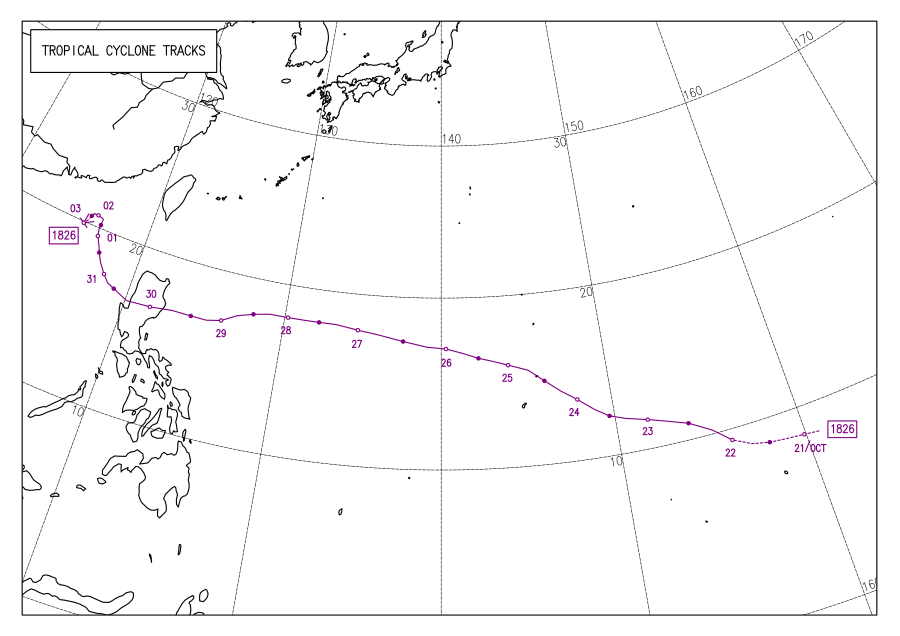
Typhoon Yutu originated on October18, 2018, from an area of atmospheric convection, or thunderstorms, near 8°36′N169°24′E / 8.6°N 169.4°E / 8.6; 169.4. Having an unorganized center with scattered convection, the tropical disturbance situated around warm waters of 29–30°C (84–86°F) and low vertical wind shear, acquiring dual outflow channels aloft—all of which aided in development.[3][4] Moving westward during October20,[5] the system received excellent equatorward outflow,[6] while intense convection wrapped into its elongated center.[7] By 18:00UTC, the JMA reported that the disturbance had intensified into a tropical depression near the Marshall Islands.[8] Eighteen hours later on October21, the United States Joint Typhoon Warning Center (JTWC) designated the consolidating system 31W.[9] A subtropical ridge to the southwest steered the storm west-northwestward, towards the Mariana Islands. Radial outflow was limited by a weak tropical upper tropospheric trough (TUTT) cell to the northwest,[10] though the cell soon diminished the next day.[11] At 00:00UTC, both the JMA and JTWC classified the system a tropical storm, with the former assigning it the name Yutu.[8][12]
Yutu expanded in size, with the strongest convection to the east and south of the center;[13] an intense rainband to the south later developed, marking the beginning of a period of explosive intensification.[14] Deep convection bloomed, obscuring the center and significantly improving its structure with substantial poleward and radial outflow.[15] At 18:00UTC, the JMA upgraded Yutu to a severe tropical storm, and six hours later on October23, both the JMA and JTWC classified the storm a typhoon.[8][12] A pinhole eye began to develop, becoming apparent on satellite imagery, with banding features continuously tightening towards the center.[16] A large area of intense thunderstorms persisted to the north of the center, as very favorable conditions fueled the typhoon.[17] Over a region of high ocean heat content, the eye became well-defined and expanded to 43km (26mi).[18] Although it soon contracted to 33km (21mi), by 00:00UTC of October 24, Yutu was classified a super typhoon by the JTWC.[19] The eye became 37km (23mi) wide, with extremely deep convective bands to the north and south of it.[20] By 12:00UTC, the JMA and JTWC reported that Yutu had attained its peak intensity; the former estimated 10-minute maximum sustained winds of 215km/h (130mph) and a barometric pressure of 900hPa (26.58inHg),[8] and the latter estimated 1-minute winds of 280km/h (175mph), making Yutu equivalent to a Category5 hurricane on the Saffir–Simpson scale.[12] Operationally, the JTWC estimated winds of 285km/h (180mph)—based on Dvorak estimates of T7.5, which utilized satellite appearance to determine intensity.[21][22]
Infrared satellite image of Typhoon Yutu directly over Tinian on October 24
Between 14:00UTC and 18:00UTC (00:00ChST and 04:00ChST of October25), Yutu struck Tinian and the southern portion of Saipan at peak intensity,[23] becoming the most powerful storm on record to impact the Northern Mariana Islands,[24][25] surpassing Typhoon Soudelor in 2015.[26] Additionally, the JTWC reported a lowest central pressure of 904hPa (26.70inHg) at 18:00UTC.[12] After striking the Mariana Islands, cold cloud tops began to warm, signaling a weakening trend. Furthermore, microwave imagery revealed concentric eyewalls, indicating the onset of an eyewall replacement cycle.[27] During the process, the eastern periphery of the eyewall thinned under the influence of dry air in the middle troposphere,[28] as wind shear became moderate during October25.[29] The primary eyewall then eroded, as an anticyclone east of the storm obstructed outflow.[30] The cycle was then completed, evident by a Special Sensor Microwave Imager/Sounder image. Yutu was more asymmetric, with its movement influenced by the subtropical ridge to the north and a large, weak mid-latitudeshortwave trough associated with it.[31] During October 26, the eye again became well-defined and expanded to 41km (25mi), as low easterly wind shear and excellent outflow persisted despite the anticyclone. Convection near the center became symmetrical,[32] cloud tops cooled, and the eye contracted and became cloud-filled.[33] The eye then sharpened and became 56km (35mi) wide as convective bands wrapped very tightly into the intense center.[34] By 18:00UTC, the JMA and the JTWC reported that Yutu had attained its secondary peak intensity; the JMA estimated winds of 195km/h (120mph) and a minimum barometric pressure of 915hPa (27.02inHg), and the JTWC gave Yutu the same wind estimate as the previous peak.[8][12]
Over the Philippine Sea, Yutu crossed the 135°E boundary of the Philippine Area of Responsibility (PAR) at 00:00UTC of October27, receiving the local name Rosita from the Philippine Atmospheric, Geophysical and Astronomical Services Administration (PAGASA).[1] Cloud tops reached −82°C (−116°F) as Yutu remained over warm waters, steering westward, though the eye became ragged.[35] Yutu then briefly entered a region of high vertical wind shear, weakening the storm.[36] The eye enlarged further to 93km (58mi) on October28, though poleward outflow weakened.[37] Intense thunderstorms eroded off the eastern edge of Yutu from dry air,[38] which wrapped into the storm's circulation from the west, with cloud tops warming and the eye contracting; on this basis, the JTWC assessed that Yutu had weakened to below super typhoon strength at 12:00UTC.[39]Sea surface temperatures had also decreased in the cold wakes of previous Typhoons Mangkhut, Trami, and Kong-reyadvected by the North Equatorial Current, contributing to the degrading of Yutu.[40] While approaching Luzon, rainbands began to collapse, after outflow had reduced. Meanwhile, Yutu steered west-southwestward along the southern edge of the subtropical ridge.[41] During October29, the eye became ill-defined and cloud-filled,[42] with most convection in the southern eyewall and limited in the northern part of it.[43] Between 20:00UTC and 21:00UTC, Yutu made landfall over Dinapigue, Isabela, Philippines, with winds of 139km/h (86mph) estimated by PAGASA.[1] The JTWC, however, reported that Yutu had made landfall at 19:50UTC. The storm continued to rapidly decay tracking westward inland over the next day.[44] Despite this, the system still remained organized as it began to emerge over the South China Sea,[45] though it weakened into a severe tropical storm at 06:00UTC according to the JMA.[8]
Moving away from the Philippines, Yutu re-consolidated from improved banding over the northern flank,[46] but weakened into a tropical storm at 18:00UTC, according to the JTWC.[12] Rainbands were limited to the north and south quadrants of the storm during October31.[47] At 06:00UTC, the JMA downgraded Yutu to a tropical storm.[8] Meanwhile, the storm left the PAR at 08:00UTC.[1] Exhibiting a partially exposed center, Yutu turned northwestward along the subtropical ridge. Regardless, the system stockpiled convection over its southern quadrant. Moreover, moderate wind shear was subdued by strong poleward outflow, making conditions favorable for intensification.[48] By November1, Yutu had briefly strengthened to near typhoon-force winds of 110km/h (70mph), according to the JTWC.[12] However, Yutu began experiencing moderate to high wind shear turning northward, limiting outflow and displacing deep convection to the northeast of the poorly defined center.[49] By November2, the JMA reported that Yutu had weakened into a tropical depression at 06:00UTC;[8] the JTWC followed suit in downgrading the system six hours later.[12] After the storm had lost all of its convection from unfavorable wind shear while 287km (178mi) southeast of Hong Kong,[50] the JTWC reported that Yutu had degenerated into a tropical disturbance at 18:00UTC,[12] whereas the JMA continued monitoring the system until it had dissipated on November3 at 06:00UTC.[8]
Preparations
Mariana Islands
Infrared satellite animation of Typhoon Yutu rapidly intensifying while approaching the Mariana Islands on October 23–24
On October20, the National Weather Service (NWS) office in Tiyan, Guam released a Special Weather Statement on the pre-Yutu disturbance after a Tropical Cyclone Formation Alert from the JTWC was issued, stating that it could impact the Mariana Islands by midweek.[51] Two days later, the NWS instated a tropical storm watch for Rota and a typhoon watch on Saipan and Tinian.[52] As Tropical Storm Yutu continued towards the archipelago, tropical storm watches were added on Guam, Alamagan, Pagan, and Agrihan.[53] With forecasts stating that Yutu would become a typhoon, the watches for Saipan and Tinian were upgraded to warnings on October23;[54] all tropical storm watches were upgraded to warnings later that day, and the typhoon watch for Rota was upgraded to a warning also.[55] After Yutu had made landfall, all warnings and watches were canceled on October25 as it moved away.[56] In the month prior to Yutu, Typhoon Mangkhut struck the Mariana Islands, prompting emergency officials to stockpile supplies. With relief supplies largely unused, storage facilities on Guam had 220,000liters of water and 260,000meals readily available.[57]
Condition of Readiness (COR) 2 was hoisted in Rota, Saipan, and Tinian on October23,[55] before it was upgraded to COR 1 the next day after Yutu had become a super typhoon.[58] Governor Ralph Torres ordered all government offices to shut down in preparation of Yutu.[59] Additionally, Northern Marianas College campuses were closed on October23.[60] The Chief Judge of the District Court, Ramona Villagomez Manglona, closed the federal court.[61] Attorney General Edward Manibusan warned retailers against price gouging.[62] Public schools canceled classes across the three main islands. Seven were used as shelter to accommodate 326 people;[63] some of them were filled quickly.[64] Hundreds of cars lined up at gas stations.[65] U.S. President Donald Trump declared an emergency for the Northern Islands on October24, which allowed the Federal Emergency Management Agency (FEMA) to deploy personnel to both Tinian and Saipan ahead of the storm.[66] The Department of Fire and Emergency Medical Services in Saipan deployed a team in preparations.[67] All flights in the Northern Marianas were canceled, though the Saipan International Airport remained open. The Commonwealth Utilities Corp. shut its water distribution system to conserve water tanks.[68] Several businesses were closed, hotel constructions were suspended, and banks, restaurants, and other shops were boarded. Imperial Pacific suspended its casino. The United States Postal Service closed its offices in Saipan and Rota. United States Coast Guard ports were closed across Saipan, Tinian, Rota, and also Guam.[69]
On October27, after Yutu (Rosita) had entered the Philippine Area of Responsibility, the PAGASA issued gale warnings across the northern and eastern seaboards of Luzon and the eastern seaboard of the Visayas, due to the enhancement of the northeast monsoon by Yutu, which could also bring light rain over Batanes, the Babuyan Islands, the Ilocos Region, the Cordillera Administrative Region (CAR), and Cagayan Valley. The agency also advised fishermen and others with small vessels to not sail in those areas, while those with larger vessels were advised to look out for big waves.[76] Starting October28, PAGASA began releasing Tropical Cyclone Wind Signals (TCWS) across regions of the Philippines; TCWS No. 1 was raised across 23 areas or provinces in the Northern Philippines.[77] Over the following days, TCWS No. 1 would span from the southern tip of Quezon to Batanes.[78] On October29, TCWS No. 2 was hoisted across Cagayan, Isabela, Aurora, Quirino, and Polillo Island, before it extended to Mountain Province, Ifugao, Benguet, and Nueva Vizcaya that same day. The signals for Isabela, Quirino, and the northern part of Aurora were raised to TCWS No. 3 along with Nueva Vizcaya and Ifugao. TCWS No. 3 was then raised across Benguet, La Union, Ilocos Sur, Mountain Province, and Pangasinan. An orange rainfall warning was issued across Bataan, Bulacan, Nueva Ecija, and Rizal, and extended to Pampanga, after Yutu had made landfall.[79] After Yutu had cross Luzon by October31, PAGASA no longer placed areas under warning signals.[80]
About 155,242 people had moved to 1,388 evacuation centers. 593 cities or municipalities across Ilocos Region, Cagayan Valley, Central Luzon, Calabarzon, the Bicol Region, CAR, and Metro Manila had classes suspended, and 193 across Ilocos, Cagayan Valley, and CAR suspended government work. 44 flights were canceled, with 38 domestic and 6 international. 2,267 passengers and 217 sea vessels were stranded while sheltering in the ports. The Department of Social Welfare and Development had stockpiled 376,330 family food packages and relief items worth ₱919.672million (US$17.463million).[79] Yutu was anticipated to produce similar effects of Typhoon Mangkhut (Ompong), which had devastated the country in September.[81] While President Rodrigo Duterte visited areas previously affected by Mangkhut ahead of Yutu, he received complaints from local government unit officials that the Commission on Audit did not allow cash advancements for the procurement of building materials intended for the victims of Mangkhut.[82]
Hong Kong
The Hong Kong Observatory (HKO) hoisted a No. 1 Standby Signal on October31 as Yutu was 670km (420mi) southeast of the region. The next day while it was 370km (230mi) southeast, the agency raised a No. 3 Strong Wind Signal, the first in November since Typhoon Ira in 1993. As it weakened however, the signal was lowered to No. 1 on November2, and was later canceled that same day.[83]
Striking Tinian and Saipan on October24 as a Category5-equivalent super typhoon, Yutu became the strongest tropical cyclone to ever impact the Mariana Islands and the second-strongest to strike the United States or its territories as a whole, tied with Typhoon Karen in 1962 and Hurricane Camille in 1969.[25][86][87] Only the 1935 Labor Day hurricane impacted the country at a greater strength.[66] Yutu was the strongest and worst storm to impact the Marianas since Typhoon Jean in 1968.[26] Meteorologist Brandon Aydlett at the NWS described the typhoon as "the storm which sets the scale for which future storms are compared to".[57] Total damage in the Northern Mariana Islands was estimated to reach over $800million, according to FEMA.[88] Based on a joint study by the Guam NWS office and the University of Guam, maximum sustained winds of 270km/h (170mph) with wind gusts of 320km/h (200mph) swept the two islands.[87] The highest wind gust was recorded at 170km/h (100mph) over Saipan at 14:44UTC on October24, before weather instruments across the island along with Tinian were damaged or destroyed. A resident recorded gusts of 270km/h (168mph) and an anemometer recorded a peak wind of 214km/h (133mph). Though 68mm (2.66in) of rain was observed at Saipan International Airport, it was likely well below the actual rainfall. A rain gauge measured 250mm (10in) of rain, though it was 4.8km (3mi) northeast of Yutu's eye.[23]
During the passage of Yutu, 121–133 people were injured. The typhoon killed two people in Saipan: a 44-year-old woman in Chalan Kanoa when it wrecked the building she was staying in, and another woman in Susupe who died of carbon monoxide poisoning caused by inhaling the fumes of a generator.[23][89] Two antenna farms from the U.S. Agency for Global Media were torn apart by the intense winds. Satellite dishes that downlinked Radio Free Asia and Voice of America were either fragmented or removed entirely.[90] The power plants of Saipan and Tinian were destroyed.[23] The entirety of both islands were left without electricity; around 200 to 300 power poles were downed, 400 to 500 were leaning, and a large amount of transformers and conductors were downed as well. Some people were injured by glass and other debris.[91] By the time the storm had passed, there were 779 downed poles in Saipan and 183 in Tinian.[92] Maximum coastal flooding in Saipan and Tinian were measured at 9.1m (30ft) and 6.1 to 7.6m (20 to 25ft) respectively.[93] Across the commonwealth, utility infrastructure was severely impacted.[94] By November5, Governor Ralph Torres stated that over 3,000 homes were destroyed, leaving thousands homeless,[95] while the American Red Cross reported that as many as 6,000 homes were destroyed and 12,000 were affected.[96] Cell towers were significantly damaged as well. Roads were inaccessible due to debris, in addition to ports.[97] In total, seven public schools in Saipan and Tinian were severely damaged.[98] The population of forest birds such as the golden white-eye, bridled white-eye, Mariana kingfisher, rufous fantail, and honeyeaters, was expected to decline as a result of the storm.[99]
The majority of buildings in southern Saipan lost their roofs or were destroyed,[91] including Hopwood Middle School, which suffered extensive damage,[100] and the gymnasium and classrooms of Northern Marianas College.[101] Yutu's eyewall also knocked out Saipan's doppler weather radar on October 25, during the storm's landfall.[25] Cars were crushed under a collapsed garage in Saipan.[91] Four hotels were closed after sustaining significant damage.[102] Low-lying vegetation in southern parts of the island were shredded or ripped from the ground.[57] The Joeten-Kiyu Public Library was flooded after its roof got damaged.[103] Saipan International Airport sustained significant damage; terminals flooded and navigation aids were rendered inoperable.[104] 462 homes were completely destroyed and 317 were severely damaged across Kagman, Lau Lau, Susupe, Chalan Kanoa, San Antonio, Koblerville, Dandan, and San Vicente.[94] Many cars had their windshield and windows shattered by debris. Powerful winds dragged a container and crashed it into two police cars behind the Department of Public Safety building in Susupe. Additionally, many trees were uprooted.[101]
Damage and debris on Tinian after Typhoon Yutu
One person was injured in Tinian.[105] The majority of homes on Tinian were severely damaged or destroyed. Some concrete structures sustained significant damage, with a few completely destroyed, and residents reported that those buildings shook during the typhoon. Storm shutters were torn from windows, leaving the interior of structures exposed to wind and water damage. In one instance, a door was ripped from a building and hurled 30m (100ft) into a pigsty.[57] The island's only health center sustained major damage; however, no patients were being treated at the time.[66] The hospital's windows and doors were damaged, and the building was inundated.[106]Tinian International Airport suffered significant damage.[104] Emergency responders rescued 30 people.[107] In total, 70 homes were destroyed and 113 were severely damaged across the villages of San Jose, the House of Taga, Carolinas, Marpo Valley and Marpo Heights.[94] In San Jose, some generators whirred among flattened buildings, 30m (100ft) trees were uprooted, road signs were twisted, and laundry shook in crumpled homes.[108] Its church was also totaled by the storm.[109]
Yutu brought typhoon-force winds over Rota, causing property and crop damage of $1million each.[110] The island was without power with over 50 downed power poles severely damaged or destroyed,[92] and 13 homes were destroyed and 38 were damaged across Songsong and Sinapalo.[94]Rota Airport received debris along its runway.[97] Guam endured tropical storm winds of 48–64km/h (30–40mph).[111] On October25, Andersen Air Force Base recorded a gust of 93km/h (58mph), while the NWS office recorded a peak gust of 85km/h (53mph). The highest rainfall from Yutu in Guam was recorded in Dededo at 1in (25mm). Yutu caused property damage of $500,000 to the island, while crop damage was estimated at $250,000.[112] The Guam Power Authority reported power outages over some parts of the island.[113]
Philippines
Infrared satellite loop of Typhoon Yutu making landfall over Luzon on October 29
Throughout the country, Yutu killed 32 people and injured two others.[79][114][115] A total of 567,691 people were affected across 19 provinces, and 438,895 had been displaced. About 66,165 homes were damaged, with 6,603 destroyed. 106 road sections and ten bridges were affected across Cagayan Valley, Central Luzon, and the Cordillera Administrative Region (CAR). About 51 transmission lines were affected by Yutu, leading to power outages throughout Luzon, though most power was quickly restored by October31. The total amount of damage to agriculture was estimated at ₱2.904billion (US$55.160million), mostly towards rice.[79] As the storm passed through Luzon, the Ambuklao and Binga Dams in Benguet, the Magat Dam near Cagayan River, and the San Roque Dam in Pangasinan all released water.[116]
At least 11 landslides were reported across Luzon.[79] On October29, both the highest wind gust of 130km/h (81mph) at 21:25UTC and lowest sea-level pressure of 971.8hPa (28.70inHg) at 21:00UTC were recorded at Casiguran, Aurora. Between 50 and 200mm (2.0 and 7.9in) of rain was estimated to have fallen over Northern Luzon, while 200 and 300mm (7.9 and 11.8in) of rain was estimated elsewhere in the island. As Yutu rapidly weakened, rainfall increased over the eastern side of Northern and Central Luzon, although surface observations suggested that orographic lifting had amplified the rainfall. The highest 24-hour rainfall was measured in Baguio at 170mm (6.7in) on October30, while the highest rainfall throughout the storm duration was measured in the same city at 177.8mm (7.00in).[1]
A total of 3,567 houses were damaged in the CAR. Most of the deaths occurred in Mountain Province, after 21 people died in Natonin when a landslide buried a Department of Public Works and Highways building. A rescuer also drowned trying to help victims of the landslide.[79] Roads were rendered impassable throughout the town as well.[117] Throughout the CAR, parts of Abra and Mountain Province and the entirety of Apayao, Benguet, Ifugao, and Kalinga all lost power. Seven landslides across Kalinga closed roads across the province; a landslide had also killed a 5-year-old girl and injured two in a home. Two elementary schools in Tanudan were submerged in flooding, though no casualties had been reported there. Another landslide damaged three classrooms and a library, and another had affected 10–15 hectares (25–37 acres) of rice fields. A footbridge had also been damaged by flooding. In Ifugao, four people died in a landslide at Banaue. A 22-year-old man in Aguinaldo drowned after being carried by a strong water current along with one of his companions who survived.[79] A total of 61,547 homes were damaged in Cagayan Valley, mainly in Isabela. The provinces of Cagayan, Isabela, Quirino, and Nueva Vizcaya had all lost power. A river near Roxas and Quirino rose rapidly, flooding low-lying areas.[79] The bridge connecting Roxas and northern Isabela was damaged by the flash flooding.[118]Cauayan Airport was closed for two days after Yutu had blew off the roof of the passenger terminal.[119] In Dinapigue, Isabela, where Yutu made landfall, several barangays were flooded and communication lines were cut off.[120] A landslide in Kayapa blocked the Benguet–Nueva Vizcaya Road, while another occurred in Ambaguio. In Bambang, six low-lying barangays were affected by flooding. In Cagayan, flooding occurred over Gattaran and Tuguegarao.[79] A truck on the Quirino Bridge overturned due to strong winds, causing traffic jams.[121] Fallen trees and debris destroyed graves in Gamu, Isabela.[122]
About 267 homes were damaged in the Ilocos Region, mainly in La Union, and 58 cities or municipalities lost power throughout the region.[79] Additionally, about 3,000 graves were flooded in Dagupan.[123] In Central Luzon, 675 houses were damaged.[79] In San Clemente, Tarlac, a man died after being electricuted while trying to help another who fell off a motorcycle near a toppled utility pole.[114][124] A rockslide in Baler, Aurora blocked the main highway to Casiguran.[125] In Calabarzon, a fishing boat carrying three fishermen capsized due to big waves near Perez, Quezon; one of them was reported missing before being declared dead by drowning. Polillo and Lucena of Quezon lost power.[79] Strong winds alongside big waves battered Tagkawayan and destroyed nine homes in General Nakar.[126] Two people died from a landslide at a quarry site in Batangas.[115] In Eastern Visayas, 109 homes were destroyed in Northern Samar,[79] including at least 10 in Pambujan that were impacted by waves reaching 3 to 5m (9.8 to 16.4ft) and 12 in Mapanas from storm surges. In Gamay, big waves affected several resorts.[127]
Hong Kong
On October31, a 25-year-old man died when surfing in Shek O Beach in Big Wave Bay, Hong Kong Island, due to high surf, while the standby typhoon signal No. 1 was hoisted.[128][83] In Tai Miu Wan, maximum sea level during the storm's passage was measured at 2.78m (9.1ft) and a maximum storm surge was measured at 0.65m (2.1ft). Over the next two days, Yutu brought cloudy weather and light rain, and overall caused no significant damage in Hong Kong.[83]
Due to the severe damage in the Northern Mariana Islands and the Philippines, the name Yutu was retired during the 52nd annual session of the ESCAP/WMO Typhoon Committee in February 2020. In February 2021, the Typhoon Committee subsequently chose Yinxing as its replacement name,[129][130] and was first used in 2024.[131]
After causing over ₱1 billion worth of damages in the Philippines, PAGASA retired the name Rosita from its rotating lists of tropical cyclone names, and will never be used again as a typhoon name within the Philippine Area of Responsibility. It was replaced with Rosal, which was first used in 2022. [132][133]
Immediately following the typhoon's impact, the Congressional Delegate for the Northern Mariana Islands, Gregorio Sablan, made a request for aid. With the scale of destruction far exceeding Typhoon Soudelor in 2015, power was not expected to be fully restored for months. Emergency shelters quickly filled to capacity on both islands by October25. The same day the U.S. Department of Health and Human Services declared a public health emergency for the affected areas and deployed 50health personnel.[66][135][92] President Trump signed a major disaster declaration on October26, enabling the islands to receive federal funding. The same day, Matson, Inc. provided $125,000 in funds and deployed its vessel Mana loaded with bottled water and ice. On October27, South Korea began airlifting approximately 1,000stranded tourists from Saipan.[135] Daytime operations at Saipan International Airport were resumed; however, damaged navigation equipment prevented safe operation during the night. The Coast Guard reopened the port of Saipan, allowing vessels to travel in and out of it.[136] On October29, Governor Ralph Torres signed an executive order postponing the 2018 Northern Mariana Islands gubernatorial election from November6 to November13, due to the effects of Yutu.[137] Media coverage of the storm was criticized by the Poynter Institute and The Atlantic for being limited, calling out news outlets that focused more on Yutu's meteorological aspect rather than its destructive effects, echoing the coverage of the death toll due to Hurricane Maria.[138]
The storm had displaced around 15,000 to 17,000 people, over a quarter of the Northern Mariana Islands population of 55,000. Federal responders provided over 1,700 tents instead of rental subsidies like they have done after Hurricanes Florence and Michael. The severe housing shortage caused FEMA to offer plane tickets out of the commonwealth, with 29 households booking tickets to Hawaii and other U.S. states. Over 3,600 people were eligible, though most of them decided to stay at the islands. Due to damaged schools, students did not have classes for over a month. Yutu had also crippled the tourism economy in the archipelago, with the islands receiving less than 6,000 visitors during November 2018, down from 48,000 last year.[139] Car rentals, hotel and restaurant bookings, and souvenir shopping all were nearly halted during a time of usual peak tourism. The Marianas Visitors Authority reported that arrivals to the Northern Mariana Islands dropped by 88%. Yutu was among the contributing factors to worsening the economy, including the closure of marketing offices due to lack of funding.[140]
Since health facilities were damaged throughout Saipan and Tinian, all patients were transported to a hospital operated by Commonwealth Healthcare Corporation (CHCC) in Saipan. Direct Relief sent emergency medical supplies to the hospital, including medical backpacks, over 40,000 water purification tablets, and oral rehydration therapy, as well as rugged tents. Moreover, the organization shipped an emergency health kit, which was enough to treat about 100 patients in 3 to 5 days. Basic personal care items were also shipped to those who were displaced.[141]Team Rubicon USA sent a reconnaissance team to Guam to determine the needs across the Northern Mariana Islands with local officials.[142] Their Emergency Medical Team (EMT) was integrated into the Tinian's health center's medical system, treating 36 homebound patients across southern Tinian. The organization also conducted storm shelter health assessments in cooperation with the World Health Organization and the CHCC.[143] About 112 people were treated by Team Rubicon's EMT.[144]AmeriCares also deployed its medical teams, delivering 3,600kg (4 short tons) of medicine and supplies.[145] The Saipan hospital was flooded with twice as many patients as on a regular day, with nearly half of them being uninsurable as guest workers, undocumented immigrants, or citizens of Pacific island nations ineligible for Medicaid. Esther Muna, the chief executive officer of the hospital, reported some patients had post-traumatic stress disorder and depression and a recent surge of storm-related suicides. Yutu also reverted the goal of providing 24-hour water to every village on Saipan achieved in September.[139] A medical team of 26 led by Sheryl Dority, a nurse for Intermountain Healthcare from South Jordan, Utah, operated for three weeks until November 7, after treating more than 1,400 patients for cleanup-related injuries.[146]
In accordance with changes implemented after Hurricane Maria in 2017, FEMA established specific task forces to handle smaller scale facets of the recovery: transportation, communications, food and water, and energy and fuel.[57] A damage assessment was then conducted by FEMA alongside the Small Business Administration (SBA) on October28.[147] The Red Cross coordinated with FEMA in sending staff and supplies, despite difficulties due to damaged airports, while supporting government-run shelters with food and water.[148] Other supplies including buckets, tarps, charging devices, stoves, lanterns, and sanitation supplies were sent to over 10,000 households. The Red Cross also helped in family reunification with satellite-equipped vehicles and assisted deployed service members.[149] FEMA and the Red Cross established five relief distribution sites on the island.[136] Overall, more than 900 people were assisted by the local government, Red Cross, and The Salvation Army.[147]
The neighboring island of Guam also provided relief, sending its engineers from the Guam Power Authority to help repair power outages and reserve water. The island's Homeland Security/Office of Civil Defense were to lead local government efforts in cleaning debris or restoring utilities, according to Guam Governor Eddie Baza Calvo. Around 140 guardmen from the Guam Army National Guard were expected to arrive and begin duty on Saipan for approximately 60 days. The Army Guard's 1224th Engineer Support Company was set to assist along with the United States Indo-Pacific Command and FEMA. In Tinian, two generators were used, one for powering a water well and for pumping water into the island's health center, and the other for powering the only hospital on the island; power remained completely offline throughout Tinian.[147] The USCGC Sequoia and USCGC Kiska ported in Guam sailed for Saipan and Tinian, respectively, with relief supplies.[135] A year after Yutu, about 546 roofs were repaired, 2,744 temporary tents and 66 temporary classrooms were established, 193 shipping containers removed 165,051m3 (215,879cuyd) of debris, and 2,144 concrete power poles were installed. Additionally, FEMA's Volunteer Agencies Leading and Organizing Repairs (VALOR) program completed 94 projects, and the SBA provided $97.4million.[89] In total, over 170 volunteers from 25 U.S. states and Canada were brought to repair homes.[150] FEMA gave $42.057million for individual and household programs, with 6,960 applications approved, $283.570million in public assistance, and $10.632million for hazard mitigation throughout the Northern Mariana Islands.[151]
The Philippine Red Cross assisted in rescue and cleanup operations, while also allocating food and relief items. Members of the Armed Forces of the Philippines rescued people who were stranded in Roxas, Isabela, and also deployed six teams totaling 63 personnel. United Nations agencies, international and national non-governmental organizations, and the private sector had operated in the affected regions since Typhoon Mangkhut, beginning rapid damage assessments. Evacuation centers in Itogon, Benguet needed food, water, blankets, sleeping mats, and hygiene equipment.[153]CARE initiated its emergency response team to coordinate with local authorities while providing immediate relief.[154] As ACT Alliance continued its assessment, the National Council of Churches in the Philippines revised its response to Typhoon Mangkhut to increase the needs for the affected families, jointly implementing projects with Christian Aid.[155] President Rodrigo Duterte started an aerial inspection over the affected areas, urging government officials for a "return to normalcy as soon as possible."[156] In a meeting, President Duterte criticized unidentified government agencies for no maintenance of government vehicles.[157]
Typhoon Hagibis (2019) – Also affected the Marianas as it was rapidly intensifying.
Typhoon Mawar (2023) – A Category5-equivalent typhoon that passed near Guam, bringing strong winds in that area.
References
12345Duran, Samuel F.; Galang, Juanito S.; Gile, Robb P.; Reyes, Sheilla Mae R.; Tolentino, Jerome T. (June 2020). DOST-PAGASA Annual Report on Philippine Tropical Cyclones 2018(PDF) (Report). Quezon City, Philippines: Government of the Republic of the Philippines Department of Science and Technology: Philippine Atmospheric, Geophysical, and Astronomical Services Administration. p.58. ISSN2672-3190. Retrieved September 12, 2024.
↑Warning and Summary 200000(TXT) (Report). Tokyo, Japan: Japan Meteorological Agency. October 20, 2018. Retrieved August 26, 2024– via Iowa Environmental Mesonet.
12...Yutu Upgraded to Super Typhoon... (Report). Tiyan, Guam: National Weather Service. October 24, 2018. Retrieved September 13, 2024– via Iowa Environmental Mesonet.
↑Event: Hurricane (Typhoon) in Rota, Guam (816109). National Centers for Environmental Information (Report). National Oceanic and Atmospheric Administration. October 24, 2018. Retrieved October 16, 2024.
↑Event: Hurricane (Typhoon) in Guam, Guam (816105). National Centers for Environmental Information (Report). National Oceanic and Atmospheric Administration. October 24, 2018. Retrieved October 16, 2024.
↑Duran, S. F.; Gile, R. P.; Reyes, S. M. R.; Bulquerin, J. E. M. Tropical Storm ROSAL (2225 PAKHAR)(PDF) (Tropical Cyclone Preliminary Summary). Quezon City, Philippines: Government of the Republic of the Philippines Department of Science and Technology: Philippine Atmospheric, Geophysical, and Astronomical Services Administration. Retrieved January 29, 2025.
This page is based on this Wikipedia article Text is available under the CC BY-SA 4.0 license; additional terms may apply. Images, videos and audio are available under their respective licenses.


