Magat Dam

Last updated

Magat Dam
Magat dam and sign.JPG
The dam, with its entrance sign in the foreground
Philippines relief location map (Luzon).svg
Red pog.svg
Location of Magat Dam in Luzon
Philippines relief location map (square).svg
Red pog.svg
Magat Dam (Philippines)
Location Alfonso Lista, Ifugao / Ramon, Isabela
Coordinates 16°49′30″N121°27′14″E / 16.82500°N 121.45389°E / 16.82500; 121.45389
Construction began1978
Opening date1982
Dam and spillways
Type of dam Rock-fill dam
Impounds Magat River
Height114 m (374 ft)
Length4,160 m (13,650 ft)
Reservoir
Surface area11.7 km2 (4.5 sq mi)
Maximum water depth193 m (633 ft)
Power Station
Installed capacity 360 MW

Magat Dam is a large rock-fill dam in the island of Luzon in the Philippines. The dam is located along the Magat River, a major tributary of the Cagayan River. The construction of the dam started in 1975 and was completed in 1982. It is one of the largest dams in the Philippines. It is a multi-purpose dam which is used primarily for irrigating about 85,000 hectares (210,000 acres) of agricultural lands, [1] flood control, and power generation through the Magat Hydroelectric Power Plant.

Contents

The water stored in the reservoir is enough to supply about two months of normal energy requirements. [1]

History

The construction and appurtenant structures were authorized by Presidential Decree No/ 693 signed on May 7, 1975, by then President Ferdinand E. Marcos. The Magat Dam was constructed in 1978, inaugurated by Marcos on October 27, 1982, [1] and started operations in 1983. [2]

Implementation of this multipurpose project was based on the preliminary study conducted in 1973 by the National Irrigation Administration (NIA) with the assistance of the United States Bureau of Reclamation (USBR) and the United States Agency for International Development (USAID).

Subsequent detailed and extensive dam site investigation and engineering studies further confirmed the feasibility of what is now known as NIA's most daring infrastructure project and one of Asia's biggest dams today.

It was Southeast Asia's first large multipurpose dam. [3] The dam is part of the Magat River Multipurpose Project (MRMP) which was financed by the World Bank and whose purpose is to improve on the existing Magat River Irrigation System (MARIS) and to triple the production of rice in the Cagayan River basin. [1]

The project was jointly financed by the Philippine Government and the World Bank which extended a US$150M loan to finance the foreign exchange requirement. In addition, a US$9M loan from Bahrain was obtained for the purchase of other equipment for the diversion tunnel, soil laboratory and model testing. The total project cost is US$3.4B (yr. 1975).

The dam was constructed to last for 50 years but increased siltation and sedimentation in the reservoir, slash-and-burn farming, illegal logging and fish-caging resulted in the deterioration of the dam's watershed. The 1990 Luzon earthquake also contributed to the increased siltation in the Magat River system. Because of this, on January 2006, then President Gloria Macapagal Arroyo instructed various government agencies to create a rehabilitation plan to improve the lifespan of the dam system. [3]

The non-power components such as the dam, reservoir, and intake gates are owned, operated, and managed by the National Irrigation Administration (NIA). The hydroelectric plant was formerly owned by the National Power Corporation (NAPOCOR). [1] Under the Electric Power Industry Reform Act of 2001 (Republic Act No. 9136), the Magat hydroelectric power plant underwent a privatization process. As a result, the plant's ownership and operation was turned over to SN Aboitiz Power-Magat, Inc. (SNAP-Magat), a joint venture of a local company, Aboitiz Power Corporation (AP), and a Norwegian firm SN Power in April 2007. [1] SNAP won the bidding in 2006. [4]

Geography

The dam is located within the boundaries of Namillangan, Alfonso Lista, Ifugao and Ramon, Isabela, approximately 350 kilometres (220 mi) north of Metro Manila.

Magat River

The Magat Dam is on the Magat River, which is the largest tributary of the Cagayan River on the island of Luzon. [5] Cagayan is the longest river in the Philippines. [5] The Magat River has an estimated yearly water discharge of 9,808 million cubic metres and has an approximate crest length of 4,160 metres (13,650 ft) with its headwaters in the province of Nueva Vizcaya and its confluence with the Cagayan River in the province of Isabela.

Features

The Magat power plant, located at the base of the dam. Magat Power Plant.JPG
The Magat power plant, located at the base of the dam.

Spillway

Diversion tunnels

Reservoir

Power

Access

It is connected by an all-weather road to San Mateo–Santiago Road at Oscariz, Ramon, Isabela some 350 kilometres (220 mi) north of Metro Manila.

Magat Hydro

The Magat hydroelectric power plant is a four-unit powerhouse with an installed capacity of 360 megawatts. [1] It is designed to accommodate two more units [7] that will allow it to generate up to 540 megawatts. The hydroelectric plant is a peaking power plant, [1] which means that it only operates when there is a high demand for electricity in the Luzon power grid, to which the plant is connected. [8] It is capable of providing ancillary services for the stability of the grid, and was augmented by a 24 MW battery in 2024. [9]

SN Aboitiz Power-Magat, Inc. completed the half-life refurbishment of the Magat Hydroelectric Power Plant in 2014. Refurbishment began in 2009 and was completed in June 2014. [10] Half-life refurbishment ensures that the power plant facility remains available throughout its life span.

Discharge-induced floods

In November 2020, Typhoon Vamco (locally known in the Philippines as Typhoon Ulysses) crossed the country, dams from all around Luzon neared their spilling points, forcing them to release large amounts of water into their impounds including Magat Dam. The dam opened all of its 7 gates at 24 meters, releasing over 5,037 cubic metres (1,331,000 US gal) of water into the Cagayan River resulting to numerous riverside towns experienced massive flooding. Waters under the Buntun Bridge went up as high as 13 meters, flooding the nearby barangays up to the roofs of houses., [11] [12] Prior to the flooding, The National Irrigation Administration said Sunday it had already warned residents of Cagayan and Isabela of Magat Dam's water release two days prior Typhoon Ulysses' landfall on November 11. [13] As a result of the catastrophe, the National Irrigation Administration said that it will review its protocols regarding the release of water in Magat Dam and improve its watershed. [14]

Related Research Articles

<span class="mw-page-title-main">Cagayan River</span> Longest river in the Philippines

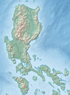
The Cagayan River, also known as the Río Grande de Cagayán, is the longest river and the largest river by discharge volume of water in the Philippines. It has a total length of approximately 505 kilometres (314 mi) and a drainage basin covering 27,753 square kilometres (10,715 sq mi). It is located in the Cagayan Valley region in northeastern part of Luzon Island and traverses the provinces of Nueva Vizcaya, Quirino, Isabela and Cagayan.

<span class="mw-page-title-main">Isabela (province)</span> Province in Cagayan Valley, Philippines

Isabela, officially the Province of Isabela, is the second largest province in the Philippines in land area located in the Cagayan Valley. Its capital and the largest local government unit is the city of Ilagan. It is bordered by the provinces of Cagayan to the north, Kalinga to the northwest, Mountain Province to the central-west, Ifugao and Nueva Vizcaya to the southwest, Quirino, Aurora and the independent city of Santiago to the south, and the Philippine Sea to the east.

<span class="mw-page-title-main">Agno River</span> River in Luzon, Philippines

The Agno River, also known as the Pangasinan River, is a river on the island of Luzon in the Philippines. Traversing the provinces of Benguet, Pangasinan, and Tarlac, it is one of the largest river systems in the country, with a drainage area of 5,952 square kilometres (2,298 sq mi).

<span class="mw-page-title-main">Typhoon Imbudo</span> Pacific typhoon in 2003

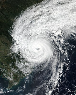
Typhoon Imbudo, known in the Philippines as Super Typhoon Harurot, was a powerful typhoon that struck the Philippines and southern China in July 2003. The seventh named storm and fourth typhoon of the season, Imbudo formed on July 15 to the east of the Philippines. The storm moved generally west-northward for much of its duration due to a ridge to the north. Favorable conditions allowed Imbudo to intensify, gradually at first before undergoing rapid deepening on July 19. After reaching typhoon status, Imbudo strengthened further to peak 10–minute sustained winds of 165 km/h (103 mph) on July 20. The typhoon made landfall on northern Luzon near peak intensity on July 22, but quickly weakened over land. Once in the South China Sea, Imbudo re-intensified slightly before making its final landfall in southern China near Yangjiang on July 24, dissipating the next day.

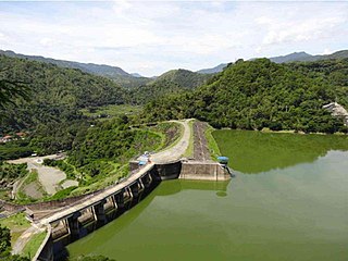
The San Roque Dam, operated under San Roque Multipurpose Project (SRMP) is a 200-meter-tall, 1.2 kilometer long embankment dam on the Agno River. It is the largest dam in the Philippines and sixteenth largest in the world. It spans the municipalities of San Manuel and San Nicolas, Pangasinan, nearly 200 km north of Metro Manila.

<span class="mw-page-title-main">Toktogul Dam</span> Dam in Toktogul

Toktogul Dam is a hydroelectric and irrigation dam on the Naryn River in the Jalal-Abad Province of Kyrgyzstan. It is concrete gravity dam with height of 215 metres (705 ft) and length of 292.5 metres (960 ft). It is a part of the Naryn-Syr Darya cascade. It is named after Toktogul Satilganov.

<span class="mw-page-title-main">Ambuklao Dam</span> Dam in Bokod, Benguet

Ambuklao Dam is part of a hydroelectric facility in Baragay Ambuclao, Bokod, Benguet province in the Philippines. With a maximum water storage capacity of 327,170,000 cubic metres (265,240 acre⋅ft), the facility, which is located 36 km (22 mi) from Baguio city, can produce up to 105 megawatts of electricity to the Luzon grid. The main source of water comes from the Agno River, which originates from Mount Data. The dam is located in a conservation area known as the Upper Agno River Basin Resource Reserve.

<span class="mw-page-title-main">Magat River</span> River in Cagayan Valley, Philippines

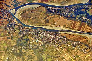
The Magat River is a river in the Philippine island of Luzon with a total length of 226 kilometres (140 mi). It originates in the Nueva Vizcaya municipality of Aritao, where the Santa Fe River joins the Marang. It is the largest tributary of the Cagayan River by discharge volume of water, with an estimated drainage area of 5,200 square kilometres (2,000 sq mi), roughly twenty percent of the total drainage area of the Cagayan River.

<span class="mw-page-title-main">Shihmen Dam</span> Dam in Taoyuan City, Taiwan

Shihmen Dam is a major rock fill dam across the Dahan River in northern Taoyuan City. It forms the Shihmen Reservoir (石門水庫), Taiwan's third largest reservoir or artificial lake. It provides irrigation in Taoyuan, flood control for the Taipei Basin, and hydroelectricity and domestic water supply for more than three million people in northern Taiwan.

<span class="mw-page-title-main">Typhoon Parma</span> Pacific typhoon in 2009

Typhoon Parma, known in the Philippines as Super Typhoon Pepeng, was the second typhoon to affect the Philippines within the span of a week during September 2009.

<span class="mw-page-title-main">Effects of the 2009 Pacific typhoon season in the Philippines</span>

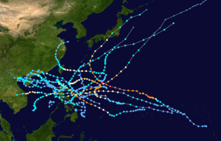
The effects of the 2009 Pacific typhoon season in the Philippines were considered some of the worst in decades. Throughout the year, series of typhoons impacted the country, with the worst damage occurring during September and October from Typhoons Ketsana (Ondoy) and Parma (Pepeng).

<span class="mw-page-title-main">Binga Dam</span> Dam in the Philippines

Binga Dam is a dam in Agno River connected to a hydroelectric power plant situated at Barrio Binga, Barangay Tinongdan in the municipality of Itogon in Benguet province of the Philippines.

<span class="mw-page-title-main">Idamalayar Dam</span> Dam in Ernakulam District, Kerala

Idamalayar Dam is a multipurpose concrete gravity dam located at Ennakkal between Ayyampuzha and Bhoothathankettu in Ernakulam district of Kerala on the Idamalayar, a tributary of the Periyar River in Kerala, South India. The dam however extends east as far as Malakkappara. Completed in 1985, with a length of 373 metres (1,224 ft) and a height of 102.8 metres (337 ft), the dam created a multipurpose reservoir covering 28.3 km2 (10.9 sq mi) in the scenic hills of the Anamalais.

<span class="mw-page-title-main">Zengwen Dam</span> Dam in Dapu, Chiyai County, Taiwan

Zengwen Dam, also spelled Tsengwen Dam, is a major earthen dam in Dapu Township, Chiayi County, Taiwan on the Zengwen River. It is the third tallest dam in Taiwan, and forms Zengwen Reservoir (曾文水庫), the biggest reservoir in Taiwan by volume. The dam stores water for irrigation of the Chianan Plain, Taiwan's most productive agricultural region, and provides flood control along the Zengwen River which flows through Tainan City. The dam supports a 50 megawatt hydroelectric power station.

<span class="mw-page-title-main">Casecnan Dam</span> Dam

Casecnan Irrigation and Hydroelectric Plant is a dam diverting water from the Casecnan and Taan Rivers to the Pantabangan Reservoir through a 26-kilometre (16 mi) long tunnel located near Pantabangan and Muñoz in Nueva Ecija province of the Philippines. The multi-purpose dam provides water for irrigation and hydroelectric power generation while its reservoir affords flood control. It was considered one of the most expensive hydroelectric plants built in the country, being next only to San Roque Dam.

<span class="mw-page-title-main">Angat Watershed Forest Reserve</span>

The Angat Watershed Forest Reserve is a conservation area that protects the drainage basin in the southern Sierra Madre range north of Metro Manila in the Philippines where surface water empties into the Angat River and its distributaries. It is spread over an area of 62,309 hectares in the eastern portion of Bulacan and northern Rizal province at an altitude of between 490 and 1,206 metres. The conservation area also extends to the provinces of Nueva Ecija and Quezon and is centered on an artificial lake created by the Angat Dam which, together with the Ipo Dam located 7.5 kilometres (4.7 mi) downstream, supply 97% of the water requirement of Metro Manila via an aqueduct system to the La Mesa Dam and Reservoir and the Balara Filtration Plant in Quezon City. The Angat Dam and Reservoir is also a major source of hydroelectricity for Metro Manila and surrounding provinces, contributing some 200 megawatts to the Luzon grid. The watershed is a popular birdwatching site and is a biodiversity hotspot containing most of the remaining closed-canopy forests in Central Luzon.

<span class="mw-page-title-main">Pantabangan–Carranglan Watershed Forest Reserve</span> Nature reserve in the Philippines

The Pantabangan–Carranglan Watershed Forest Reserve is a conservation area located in the upper reaches of the Pampanga River in Nueva Ecija, Philippines, and borders the Sierra Madre and Caraballo Mountains in Aurora and Nueva Vizcaya. It encompasses 84,500 hectares of the drainage basin surrounding the Pantabangan Lake, an impoundment of the Pampanga River by the Pantabangan Dam. The multi-purpose dam is situated at the confluence of Pampanga River's two headwaters, namely the Pantabangan and Carranglan Rivers in the municipality of Pantabangan. It stretches above the dam site for 21 kilometres (13 mi) to where Carranglan River originates in the Caraballo on the north, and for 18 kilometres (11 mi) to where Pantabangan River originates in the Sierra Madre on the east. It is considered a critical watershed for the agricultural economy and hydroelectric power generation in the region of Central Luzon.

<span class="mw-page-title-main">Aboitiz Power</span>

Aboitiz Power Corporation also known as AboitizPower (AP), a subsidiary of Aboitiz Equity Ventures (AEV), is a holding company engaged in power distribution, generation and retail electricity services.

<span class="mw-page-title-main">Upper Agno River Basin Resource Reserve</span>

The Upper Agno River Basin Resource Reserve is a protected area located on the southeast flank of the Cordillera Central in the Philippine province of Benguet along its border with Ifugao and Nueva Vizcaya. It is a resource reserve located high in the Central and Polis ranges protecting the headwaters of the Agno River. According to section 4 of the National Integrated Protected Areas System Act, a resource reserve is an extensive and relatively isolated area designated as such to preserve the natural resources of the area. The reserve comprises 77,561 hectares of the catchment area that feeds the Ambuklao and Binga dams, two of the country's oldest hydroelectric plants that supply power to the city of Baguio and entire Benguet province. Upper Agno is north of and contiguous with the Lower Agno Watershed Forest Reserve that preserves the immediate downstream of the Binga Dam where the Agno River is impounded by a third dam, the San Roque Dam, the largest in the Philippines and the main source of water, electric energy and irrigation for surrounding regions in Luzon.

<span class="mw-page-title-main">Typhoon Vamco</span> Pacific typhoon in 2020

Typhoon Vamco, known in the Philippines as Typhoon Ulysses, was a powerful and very destructive Category 4-equivalent typhoon that struck the Philippines and Vietnam. It also caused the worst flooding in Metro Manila since Typhoon Ketsana in 2009. The twenty-second named storm and tenth typhoon of the 2020 Pacific typhoon season, Vamco originated as a tropical depression northwest of Palau, where it slowly continued its northwest track until it made landfall in Quezon. After entering the South China Sea, Vamco further intensified in the South China Sea until it made its last landfall in Vietnam.

References

  1. 1 2 3 4 5 6 7 8 "Magat Hydro: Environmental & Social Review Summary" – International Finance Corporation (World Bank)
  2. "Magat Hydro". ifcext.ifc.org. Retrieved January 14, 2016.
  3. 1 2 "Arroyo orders officials to formulate plan for massive rehabilitation of Magat Dam". Manila Bulletin. January 6, 2006. Retrieved April 21, 2008.
  4. "Ifugao, Isabela share natl wealth tax over Magat dam after legal battle". GMANews.TV. GMA Network. April 4, 2008. Retrieved April 21, 2008.
  5. 1 2 "The Cagayan River Basin" – PAGASA. Accessed on April 21, 2008.
  6. 1 2 3 4 "Magat". www.snaboitiz.com. Retrieved January 14, 2016.
  7. "Phillippines [sic] – SNPower". www.snpower.com. Retrieved January 14, 2016.
  8. Visaya, Villamor Jr. (July 29, 2007). "Gov't starts cloud-seeding over Magat dam". INQUIRER.net. Philippine Daily Inquirer.
  9. Colthorpe, Andy (February 5, 2024). "Philippines: Scatec-Aboitiz Power JV begins operation of battery storage at hydroelectric plant". Energy-Storage.News.
  10. "Magat". www.snaboitiz.com. Retrieved January 14, 2016.
  11. "Robredo assures Cagayan Valley: We heard you, gov't finding ways to reach you". November 13, 2020.
  12. "Cagayan province turned into 'Pacific Ocean': Disaster management official". November 13, 2020.
  13. "Residents near Ipo, Ambuklao, Binga, and Magat dams warned of flooding as reservoirs continue to release water". Manila Bulletin .
  14. "NIA to review protocols on Magat Dam water release after Cagayan, Isabela floods". November 17, 2020.