Ipo Dam

Last updated

Ipo Dam
01510jfHilltop San Mateo Sitio Bitbit Lorenzo River Bridge Norzagaray Bulacan villagesfvf 13.JPG
View of Ipo Dam from San Mateo, Norzagaray, Bulacan.
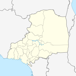
Philippines Bulacan location map.svg
Red pog.svg
Location in Bulacan
Philippines relief location map (Luzon mainland).svg
Red pog.svg
Location in Luzon
Philippines relief location map (square).svg
Red pog.svg
Location in the Philippines
Official nameIpo Dam
LocationBarangay San Mateo, Norzagaray, Bulacan, Philippines
Coordinates 14°52′N121°09′E / 14.867°N 121.150°E / 14.867; 121.150
Construction began1935 (1935)
Opening dateDecember 1938 (1938-12)
January 1984 (1984-01)
Operator(s) Metropolitan Waterworks and Sewerage System
Dam and spillways
Impounds Angat River
Reservoir
CreatesIpo Reservoir
Total capacity7.5×10^6 m3 (260×10^6 cu ft)

Ipo Dam is a concrete water reservoir gravity dam found in the Philippines. The dam is located about 7.5 kilometres downstream of the Angat Dam within the Angat Watershed Forest Reserve in Norzagaray, Bulacan. It was a part of the Angat-Ipo-La Mesa water system. Its normal level is 101 m.

The Ipo Dam is a gravity concrete dam located about 7.5 kilometres downstream of the Angat Dam near its confluence with the Ipo River in Bulacan. It was completed in January 1984 with a maximum storage capacity of 7.5 million cubic metres, an increase of about 2,500 million litres per day (MLD) from the old Ipo Dam, which was completed in December 1938, used to be located 200 metres upstream of the new dam.

The spill level of the dam is at an elevation of 101 metres and it has seven radial floodgates. The watershed topography is characterised by mountainous terrain similar to the Angat Reservoir Watershed with moderate forest cover. The watershed has an area of about 70 square kilometers and receives an average annual rainfall of 3,500 millimeters. Tributaries to the Angat River at this section include the Ipo, Sapa Pako and Sapa Anginon Rivers. These tributaries drain into the Angat River from the eastern section of the watershed.

Water from the dam is diverted to the Novaliches Portal and the La Mesa Dam through three intake structures going down to three connecting tunnels into five connecting aqueducts.
Battle of Ipo Dam

Aerial view of Ipo Dam on Angat River, 1940 Philippine Island - Angat River - NARA - 68155812.jpg
Aerial view of Ipo Dam on Angat River, 1940

On May 19, 1945, during World War II, the dam was captured in the Battle of Ipo Dam. The Yay Regiment of the Marking Guerrillas, under the command of Col. Marcos V. Agustin, and the US Army's 43rd Division, supported by the Fifth Air Force, captured the water source intact from the Japanese defenders. [1]

Related Research Articles

<span class="mw-page-title-main">Chambal River</span> River in India

The Chambal River is a tributary of the Yamuna River in Central and Northern India, and thus forms part of the drainage system of the Ganges. The river flows north-northeast through Madhya Pradesh, running for a time through Rajasthan, then forming the boundary between Rajasthan and Madhya Pradesh before turning southeast to join the Yamuna in Uttar Pradesh state.

<span class="mw-page-title-main">Norzagaray</span> Municipality in Bulacan, Philippines

Norzagaray, officially the Municipality of Norzagaray, is a 1st class municipality in the province of Bulacan, Philippines. According to the 2020 census, it has a population of 136,064 people.

<span class="mw-page-title-main">Periyar River</span> River in Kerala, India

Periyar, IPA:[peɾijɐːr], is the longest river and the river with the largest discharge potential in the Indian state of Kerala. It is one of the few perennial rivers in the region and provides drinking water for several major towns. The Periyar is of utmost significance to the economy of Kerala. It generates a significant proportion of Kerala's electrical power via the Idukki Dam and flows along a region of industrial and commercial activity. The river also provides water for irrigation and domestic use throughout its course besides supporting a rich fishery. Due to these reasons, the river has been named the "Lifeline of Kerala". Kochi city, in the vicinity of the river mouth, draws its water supply from Aluva, an upstream site sufficiently free of seawater intrusion. Twenty five percent of Kerala's industries are along the banks of the Periyar. These are mostly crowded within a stretch of 5 kilometres (3 mi) in the Eloor-Edayar region (Udhyogamandal), about 10 kilometres (6 mi) north of Kochi harbor.

<span class="mw-page-title-main">Gandhi Sagar Dam</span> Dam in Mandsaur District Madhya Pradesh

The Gandhi Sagar Dam is one of the four major dams built on India's Chambal River. The dam is located in the Mandsaur district of the state of Madhya Pradesh. It is a masonry gravity dam, standing 62.17 metres (204.0 ft) high, with a gross storage capacity of 7.322 billion cubic metres from a catchment area of 22,584 km2 (8,720 sq mi). The dam's foundation stone was laid by Prime Minister of India Pandit Jawaharlal Nehru on 7 March 1954, and construction of the main dam was done by leading contractor Dwarka Das Agrawal & Associates and was completed in 1960. Additional dam structures were completed downstream in the 1970s.

<span class="mw-page-title-main">Angat River</span> River in Central Luzon, Philippines

The Angat River is a river in the Philippines located in the province of Bulacan. It flows from the Sierra Madre mountain range to Manila Bay. Three dams are located along the river namely Angat, Ipo and Bustos. The catchment or basin area of the river is 1,085 square kilometres (419 sq mi) located in the Angat Watershed Forest Reserve. Angat River snakes through the municipalities of Doña Remedios Trinidad, Norzagaray, Angat, Bustos, San Rafael, Baliwag, Plaridel formerly "Quingua", Pulilan, Calumpit, Paombong, and Hagonoy. The river joins the Pampanga River at Calumpit via the Bagbag River.

<span class="mw-page-title-main">Manila Water</span>

Manila Water Company, Inc. has the exclusive right to provide water and used water (wastewater) services to over six million people in the East Zone of Metro Manila. It is a subsidiary of Enrique Razon's Trident Water Holdings Company, Inc., who acquired stakes from the country's oldest conglomerate, Ayala Corporation, in 2024.

<span class="mw-page-title-main">Muscoot Reservoir</span> Reservoir in New York state, USA

The Muscoot Reservoir is a reservoir in the New York City water supply system in northern Westchester County, New York, located directly north of the village of Katonah. Part of the system's Croton Watershed, it is 25 miles north of the City.

<span class="mw-page-title-main">La Mesa Dam and Reservoir</span> Dam in Quezon City, Philippines

The La Mesa Dam and Reservoir is an earth dam in Quezon City, Philippines. Its reservoir can hold up to 50.5 million cubic meters, occupying an area of 27 square kilometers (10 sq mi). It is part of the Angat-Ipo-La Mesa water system, which supplies most of the water in Metro Manila.

<span class="mw-page-title-main">Angat Dam</span> Dam in Bulacan, Philippines

Angat Dam is a concrete water reservoir embankment hydroelectric dam in the Philippines that supplies Metro Manila and nearby provinces with water. It was a part of the Angat-Ipo-La Mesa water system. The reservoir supplies about 90 percent of raw water requirements for Metro Manila through the facilities of the Metropolitan Waterworks and Sewerage System and it irrigates about 28,000 hectares of farmland in the provinces of Bulacan and Pampanga.

<span class="mw-page-title-main">Rangit Dam</span> Dam in India

Rangit Dam, which forms the headworks of the Rangit Hydroelectric Power Project Stage III, is a run-of-the-river hydroelectric power project on the Ranjit River, a major tributary of the Teesta River in the South Sikkim district of the Northeastern Indian state of Sikkim. The project's construction was completed in 1999. The project is fully functional since 2000. The project was built at a cost of Rs 4922.6 million. The average annual power generation from the 60 MW project is 340 GWh with firm power of 39 MW.

The Lochaber hydroelectric scheme is a hydroelectric power generation project constructed in the Lochaber area of the western Scottish Highlands after the First World War. Like its predecessors at Kinlochleven and Foyers, it was designed to provide electricity for aluminium production, this time at Fort William.

<span class="mw-page-title-main">El Quimbo Dam</span> Dam in Colombia

The El Quimbo Dam is a concrete faced rock-fill dam (CFRD) and hydroelectric power facility in the Huila Department of southwestern-central Colombia, approximately 69 kilometres (43 mi) south of the city of Neiva, on the Magdalena River. It is located about 1,300 metres (4,300 ft) upstream from the confluence of the Páez River with the Magdalena River. Its works were officially opened on February 25, 2011 in the presence of President Juan Manuel Santos. It is one of the largest infrastructure projects in the country. The project was completed 4 years later, in late 2015.

<span class="mw-page-title-main">Daecheong Dam</span> Dam in Daejeon

The Daecheong Dam is a combination concrete gravity and embankment dam on the Geum River, 16 km (10 mi) north of Daejeon in South Korea. The multi-purpose dam provides benefits of flood control, water supply and hydroelectric power generation. Construction on the dam began in 1975 and was formally commissioned on 1 December 1980. The 72 m (236 ft) high rock-fill dam has a central clay core and has created a reservoir with storage of 1,490,000,000 m3 (1,207,963 acre⋅ft).

<span class="mw-page-title-main">Wushe Dam</span> Dam in Renai, Nantou County, Taiwan

Wushe Dam is a gravity dam forming Wushe Reservoir, also called Wanda Reservoir and Bihu, on the Wushe Creek, a tributary of the Zhuoshui River, located in Ren-ai Township, Nantou County, Taiwan. The dam was completed in 1960 after seven years of construction, and serves mainly to generate hydroelectric power.

<span class="mw-page-title-main">Nanaimo River</span> River on Vancouver Island, Canada

Nanaimo River is a river on Vancouver Island, British Columbia, Canada, located near the city of Nanaimo on the island's east coast. Its headwaters are in the Vancouver Island Ranges of central Vancouver Island and its mouth, the Nanaimo River estuary, is at the south end of Nanaimo Harbour in the Strait of Georgia. The estuary is part of the Pacific Estuary Conservation Program.

<span class="mw-page-title-main">La Mesa Watershed Reservation</span> Protected area in Metro Manila, Philippines

The La Mesa Watershed Reservation is a protected area that preserves the only major watershed in Metro Manila, Philippines. Also known as the Novaliches Watershed, it contains the last remaining rainforest of its size in Metro Manila surrounding the La Mesa Dam and Reservoir, the primary source of potable drinking water for 12 million residents in the Manila metropolitan area. The area is under jointly controlled and supervised by the Department of Environment and Natural Resources and the Metropolitan Waterworks and Sewerage System. It was established in 2007 through Proclamation No. 1336 issued by President Gloria Macapagal Arroyo.

<span class="mw-page-title-main">Angat Watershed Forest Reserve</span>

The Angat Watershed Forest Reserve is a conservation area that protects the drainage basin in the southern Sierra Madre range north of Metro Manila in the Philippines where surface water empties into the Angat River and its distributaries. It is spread over an area of 62,309 hectares in the eastern portion of Bulacan and northern Rizal province at an altitude of between 490 and 1,206 metres. The conservation area also extends to the provinces of Nueva Ecija and Quezon and is centered on an artificial lake created by the Angat Dam which, together with the Ipo Dam located 7.5 kilometres (4.7 mi) downstream, supply 97% of the water requirement of Metro Manila via an aqueduct system to the La Mesa Dam and Reservoir and the Balara Filtration Plant in Quezon City. The Angat Dam and Reservoir is also a major source of hydroelectricity for Metro Manila and surrounding provinces, contributing some 200 megawatts to the Luzon grid. The watershed is a popular birdwatching site and is a biodiversity hotspot containing most of the remaining closed-canopy forests in Central Luzon.

<span class="mw-page-title-main">Fiumorbo</span> River in the department of Haute-Corse, Corsica

The Fiumorbo is a coastal river in the department of Haute-Corse, Corsica, France. It is dammed in two places to supply irrigation water and hydroelectricity. Between the two dams it runs through the spectacular Défilé de l’Inzecca, a Natura 2000 site.

<span class="mw-page-title-main">Barrage de Corscia</span> Reservoir in Corsica

The Barrage de Corscia is a dam in the Haute-Corse department of France on the Golo river. It impounds an intermediate reservoir in the Golo hydroelectric complex. The Corscia hydroelectric power station fed by water channeled from Lac de Calacuccia has a capacity of 13 mW and discharges into the Corscia reservoir. Downstream from the Corscia reservoir there is another power station at Castirla.

The Marking Guerrillas were a Filipino guerrilla army that took part in the anti-Japanese resistance during the Japanese occupation of the Philippines in World War II. Headed by Colonel Marcos V. "Marking" Agustin and Valeria "Yay" Panlilio, the army is most well known for carrying out the capture of former Philippine president Emilio Aguinaldo during his collaboration with Japan, as well as the unit's role in the battle to capture the Ipo Dam from the Japanese.

References

  1. Panlilio, Yay (1950). The Crucible: An Autobiography by Colonel Yay, Filipina American Guerrilla . New Brunswick: Rutgers University Press. pp.  307-310. ISBN   9780813546827.