Pantabangan Dam

Last updated
Pantabangan Dam
Pantabangan Dam.jpg
Behind the dam's spillway
Philippines Nueva Ecija relief location map.svg
Red pog.svg
Location of Pantabangan Dam in Nueva Ecija
Philippines relief location map (Luzon).svg
Red pog.svg
Pantabangan Dam (Luzon)
Philippines relief location map (square).svg
Red pog.svg
Pantabangan Dam (Philippines)
Coordinates 15°48′52″N121°06′29″E / 15.81444°N 121.10806°E / 15.81444; 121.10806 Coordinates: 15°48′52″N121°06′29″E / 15.81444°N 121.10806°E / 15.81444; 121.10806
Construction beganJune 1971
Opening dateSeptember 1974
Construction cost$20.74 Million or 891.82 Million pesos (at current price)
Owner(s) National Power Corporation
National Irrigation Administration
Dam and spillways
Type of dam Embankment, earth-fill
Impounds Pampanga River
Height107 m (351 ft)
Length1,615 m (5,299 ft)
Elevation at crest232 m (761 ft)
Width (crest)12 m (39 ft)
Width (base)535 m (1,755 ft)
Dam volume12,000,000 cu yd (9,174,658 m3)
Spillways 3 x radial gates, 1 x overflow
Spillway capacity4,200 m3/s (148,322 cu ft/s)
Reservoir
CreatesPantabangan Lake
Total capacity2,996,000,000 m3 (2,428,897 acre⋅ft)
Active capacity2,083,000,000 m3 (1,688,716 acre⋅ft)
Catchment area 853 km2 (329 sq mi)
Surface area69.62 km2 (27 sq mi) (max)
Normal elevation230 m (755 ft) (max)
Commission date1974
Turbines 2 x 60 MW Francis-type
Installed capacity 100 MW
Capacity factor 90%
Annual generation 232,000,000 kWh

Pantabangan Dam is an earth-fill embankment dam on the Pampanga River located in Pantabangan in Nueva Ecija province of the Philippines. The multi-purpose dam provides water for irrigation and hydroelectric power generation while its reservoir, Pantabangan Lake, affords flood control. The reservoir is considered one of the largest in Southeast Asia and also one of the cleanest in the Philippines. Construction on the dam began in 1971 and it was completed in 1974.

Contents

History

In May 1969, the Congress of the Philippines authorized the development of the Pampanga Basin with Republic Act No. 5499. In October of that year, detailed studies of the Pantabangan site were carried out and lasted two years. [1] By June 11, 1971, Pantabangan was an old town of around 300 years old. President Ferdinand Marcos and many others arrived for a ground breaking ceremony in Palayupay, Pantabangan, Nueva Ecija, to signal the beginning of the construction of Pantabangan Dam. [2] The dam went into operation in February 1977 and was completed later in May. [1] Approximately 1,300 people were relocated from the dam's reservoir zone. [3]

Design

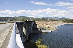
The dam is a 107 m (351 ft) tall and 1,615 m (5,299 ft) long embankment-type with 12,000,000 cu yd (9,174,658 m3) of homogeneous earth-fill and an impervious core. The crest of the dam is 12 m (39 ft) wide while the widest part of its base is 535 m (1,755 ft). The dam's crest sits at an elevation of 232 m (761 ft) and is composed of three sections: the main dam, a saddle dam, and an auxiliary dam located with the spillway. The spillway is a chute-type controlled by three radial gates but equipped with an overflow section as well. The design discharge of the spillway is 4,200 m3/s (148,322 cu ft/s). The dam's reservoir has a gross capacity of 2,996,000,000 m3 (2,428,897 acre⋅ft) and 2,083,000,000 m3 (1,688,716 acre⋅ft) of that volume is active (or useful) for irrigation and power. The dam sits at the head of a 853 km2 (329 sq mi) catchment area known as the Pantabangan–Carranglan Watershed Forest Reserve and its reservoir has a surface area of 69.62 km2 (27 sq mi) and elevation of 230 m (755 ft) when at its maximum level. The reservoir's life is estimated at 107 years due to silt from denudation. [1] The dam was designed to withstand an intensity 8 earthquake. [4]

The power house is located at the base of the main dam and contains two 60 MW Francis turbine-generators for an installed capacity of 120 MW. Each turbine receives water via a 6 m (20 ft) diameter penstock. When the water is discharged, it is released into a 250 m (820 ft) long tailrace channel where it re-enters the river. [1]

Related Research Articles

Mangla Dam Multipurpose dam in Azad Jammu and Kashmir, Pakistan

The Mangla Dam is a multipurpose dam situated on the Jhelum River in the Mirpur District of Azad Jammu and Kashmir, Pakistan. It is the sixth-largest dam in the world. The village of Mangla, which sits at the mouth of the dam, serves as its namesake. In November 1961, the project's selected contractors were revealed; it was announced that Binnie & Partners, a British engineering firm, was going to serve as the lead designers, engineers, and inspectors for the construction of the dam. The project was undertaken by a consortium known as the Mangla Dam Contractors, which consisted of eight American construction firms sponsored by the Guy F. Atkinson Company based in South San Francisco, California.

Wyangala Dam Dam in New South Wales, Australia

Wyangala Dam is a major gated rock fill with clay core embankment and gravity dam with eight radial gates and a concrete chute spillway across the Lachlan River, located in the south-western slopes region of New South Wales, Australia. The dam's purpose includes flood mitigation, hydro-power, irrigation, water supply and conservation. The impounded reservoir is called Lake Wyangala.

The Xiaowan Dam is an arch dam on the Lancang (Mekong) River in Nanjian County, Yunnan Province, southwest China. The primary purpose of the dam is hydroelectric power generation and it supports a 4,200 MW power station. Constructed between 2002 and 2010 by Huaneng Power International at a cost of ¥32 billion, it is the world's second highest arch dam at 292 m (958 ft). It is also third highest among dams of all types behind Jinping-I and Nurek and the third largest hydroelectric power station in China.

Canyon Ferry Dam Dam in Montana, USA

Canyon Ferry Dam is a concrete gravity dam in a narrow valley of the Missouri River, United States, where the Big Belt Mountains and the Spokane Hills merge, approximately 68 miles (109 km) downstream from the confluence of the Gallatin, Madison, and Jefferson rivers, and about 20 miles (32 km) east of the city of Helena, Montana. The dam is for flood control, irrigation, recreation and hydroelectric power. The building of the dam created a reservoir known as Canyon Ferry Lake.

Darbandikhan Dam Dam in Darbandikhan, Kurdistan Region.

The Darbandikhan Dam is a multi-purpose embankment dam on the Diyala River in northern Sulaymaniyah Governorate, Iraq. It was constructed between 1956 and 1961. The purpose of the dam is irrigation, flood control, hydroelectric power production and recreation. Due to poor construction and neglect, the dam and its 249 MW power station have undergone several repairs over the years. A rehabilitation of the power station began in 2007 and was completed in 2013.

Aras Dam Dam in Poldasht, Nakhchivan

The Aras Dam is an embankment dam on the Aras River along the border of Iran and Azerbaijan. It is located downstream of Poldasht in West Azerbaijan Province, Iran and Nakhchivan City in Nakhchivan Autonomous Republic, Azerbaijan. The primary purpose of the dam is hydroelectric power production and water supply.

Bhadra Dam Dam in Karnataka, India

The Bhadra Dam or Lakkavalli Dam, which has created the Bhadra Reservoir, is located on the Bhadra River a tributary of Tungabhadra River. Bhadra Dam is located in the border of Bhadravathi and Tarikere, in the western part of Karnataka in India. The benefits derived from the reservoir storage are irrigation with gross irrigation potential of 162,818 hectares, hydro power generation of 39.2 MW, drinking water supply and industrial use. The dam commissioned in 1965 is a composite earth cum masonry structure of 59.13 metres (194.0 ft) height with length of 1,708 metres (5,604 ft) at the crest level, which submerges a land area of 11,250.88 hectares.

Sirikit Dam Dam in Tha Pla, Uttaradit

The Queen Sirikit Dam is an embankment dam on the Nan River, a tributary of the Chao Phraya River, in Tha Pla District, Uttaradit Province, Thailand. It is at the southeastern edge of the Phi Pan Nam Range. The dam was built for the purpose of irrigation, flood control and hydroelectric power production. It is named after Sirikit, Queen of Thailand.

La Yesca Dam Dam in La Yesca

La Yesca Dam is an embankment dam on the Santiago River 90 km (56 mi) northwest of Guadalajara on the border of Mexico's Nayarit and Jalisco states. Construction on the dam began in 2007 after Empresas ICA was awarded the main construction contract. The dam was inaugurated by President Felipe Calderón on 6 November 2012. The dam supports a 750 MW hydroelectric power station and is part of the Hydroelectric System Santiago. Its construction will improve the regulation of water flow and subsequently power generation downstream at the El Cajón and Aguamilpa Dams.

Ramganga Dam Dam in Kalagrh

The Ramganga Dam, also known as the Kalagarh Dam, is an embankment dam on the Ramganga River 3 km (2 mi) upstream of Kalagarh in Pauri Garhwal district, Uttarakhand, India. It is located within the Jim Corbett National Park.

The Koteshwar Dam is a gravity dam on the Bhagirathi River, located 22 km (14 mi) downstream of the Tehri Dam in Tehri District, Uttarakhand, India. The dam is part of the Tehri Hydropower Complex and serves to regulate the Tehri Dam's tailrace for irrigation and create the lower reservoir of the Tehri Pumped Storage Power Station. In addition, the dam has a 400 MW run-of-the-river power station. The project was approved in 2000 and its first generator was commissioned on 27 March 2011, the second on 30 March 2011. The construction site had been inundated in September 2010 by floods. The diversion tunnel was later blocked heaving/collapse of the hill in December 2010. The spillway was commissioned in Jan, 2011. The last two generators were made operational in March 2012.

The Dongfeng Dam is an arch dam on the Wu River 65 km (40 mi) northwest of Qingzhen in Guizhou Province, China. The primary purpose of the dam is hydroelectric power generation and it supports a 570 MW power station. Construction on the dam began in 1989 and the first generator was operational in 1994, the last in 1995. The generators were up-rated between 2004 and 2005; bringing their capacity from 170 MW each to 190 MW.

The Hunanzhen Dam is a trapezoidal buttress dam on the Qiantang River, located 27 km (17 mi) south of Quzhou in Zhejiang Province, China. The primary purpose of the dam is hydroelectric power generation but it also serves to provide for flood control and irrigation water supply. Construction on the dam began in 1958 but was halted in 1961. It recommenced in 1970, the first generator was operational in 1979 and the project complete in 1980. The original installed capacity of the dam's power plant was 170 MW but the plant was expanded with an additional 100 MW generator, commissioned in 2006.

The Jiangya Dam is a concrete gravity dam on the Loushui River, located 50 km (31 mi) northeast of Zhangjiajie in Hunan Province, China. The primary purpose of the multi-purpose dam is flood control but it also generates hydroelectricty, supplies water for irrigation and municipal use and improves navigation.

The Pong Dam, also known as the Beas Dam, is an earth-fill embankment dam on the Beas River in the state of Himachal Pradesh, India, just upstream of Talwara. The purpose of the dam is water storage for irrigation and hydroelectric power generation. As the second phase of the Beas Project, construction on the dam began in 1961 and was completed in 1974. At the time of its completion, the Pong Dam was the tallest of its type in India. The lake created by the dam, Maharana Pratap Sagar, became a renowned bird sanctuary.

Jatigede Dam Dam in Sumedang, West Java

The Jatigede Dam is an embankment dam on the Cimanuk River in Sumedang Regency, West Java, Indonesia. It is located 19 km (12 mi) east of the town of Sumedang. Construction on the dam began in 2008 and it was completed in 2015. The power station is expected to be commissioned in 2019. The primary purpose of the dam is irrigation but it will also provide for flood control, water supply and hydroelectric power generation. Water in the reservoir will be used to help irrigate 90,000 ha of farmland and the power station is expected to have a 110 MW capacity. The project has become controversial, primarily due to the relocation of people in the future reservoir zone.

Casecnan Dam Dam

Casecnan Irrigation and Hydroelectric Plant is a dam diverting water from the Casecnan and Taan Rivers to the Pantabangan Reservoir through a 26-kilometre (16 mi) long tunnel located near Pantabangan and Muñoz in Nueva Ecija province of the Philippines. The multi-purpose dam provides water for irrigation and hydroelectric power generation while its reservoir affords flood control. It was considered one of the most expensive hydroelectric plants built in the country, being next only to San Roque Dam.

Randenigala Dam Dam in Rantembe, Central Province

The Randenigala Dam is a large hydroelectric embankment dam at Rantembe, in the Central Province of Sri Lanka. Construction of the dam began in November 1982, and was completed in approximately 4 years. The dam and power station was ceremonially opened by then President J. R. Jayawardene in 1986.

The Kayrakkum Dam, also spelt variously as Kayrakum, Kairakum, Qayraqqum or Qayroqqum, is an embankment dam on the Syr Darya River near the town of Kayrakkum in Sughd Province, Tajikistan. It is situated on the western edge of the Fergana Valley and creates Kayrakkum Reservoir. The reservoir supplies water for irrigation, primarily in Uzbekistan downstream, and hydroelectric power production. The reservoir is also a Ramsar site. The dam's power station has an installed capacity of 126 MW and is operated by Barki Tojik. Construction on the dam began in 1952. It began to impound its reservoir in 1956 and the first two generators were commissioned that year. The other four were operational in 1957 and the project was complete in 1959. The power station is currently undergoing a rehabilitation which should be completed in 2020. Two new and larger turbines will increase the installed capacity to 142 MW.

Pantabangan–Carranglan Watershed Forest Reserve

The Pantabangan–Carranglan Watershed Forest Reserve is a conservation area located in the upper reaches of the Pampanga River in Nueva Ecija, Philippines, and borders the Sierra Madre and Caraballo Mountains in Aurora and Nueva Vizcaya. It encompasses 84,500 hectares of the drainage basin surrounding the Pantabangan Lake, an impoundment of the Pampanga River by the Pantabangan Dam. The multi-purpose dam is situated at the confluence of Pampanga River's two headwaters, namely the Pantabangan and Carranglan Rivers in the municipality of Pantabangan. It stretches above the dam site for 21 kilometres (13 mi) to where Carranglan River originates in the Caraballo on the north, and for 18 kilometres (11 mi) to where Pantabangan River originates in the Sierra Madre on the east. It is considered a critical watershed for the agricultural economy and hydroelectric power generation in the region of Central Luzon.

References

  1. 1 2 3 4 "Pantabangan Dam". Database of Water-Related Projects in The Republic of the Philippines. Archived from the original on 5 October 2011. Retrieved 4 November 2011.
  2. "PANTABANGAN DAM". Archived from the original on 2012-04-25. Retrieved 2011-11-03.
  3. McDowell, Christopher, ed. (1996). Understanding impoverishment : the consequences of development induced displacement (1. publ. ed.). Providence, RI [u.a.]: Berghahn. p. 170. ISBN   1-57181-916-9.
  4. Cervantes, Ding (13 April 2011). "NIA: Pantabangan Dam can withstand Intensity 8 quake". The Philippine Star. Retrieved 4 November 2011.