
The Pampanga River is the second largest river on the island of Luzon in the Philippines and the country's fifth longest river. It is in the Central Luzon region and traverses the provinces of Pampanga, Bulacan, and Nueva Ecija.

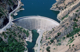
New Melones Dam is an earth and rock filled embankment dam on the Stanislaus River, about 5 miles (8.0 km) west of Jamestown, California, United States, on the border of Calaveras County and Tuolumne County. The water impounded by the 625-foot-tall (191 m) dam forms New Melones Lake, California's fourth-largest reservoir, in the foothills of the Sierra Nevada east of the San Joaquin Valley. The dam serves mainly for irrigation water supply, and also provides hydropower generation, flood control, and recreation benefits.

Friant Dam is a concrete gravity dam on the San Joaquin River in central California in the United States, on the boundary of Fresno and Madera Counties. It was built between 1937 and 1942 as part of a U.S. Bureau of Reclamation (USBR) water project to provide irrigation water to the southern San Joaquin Valley. The dam impounds Millerton Lake, a 4,900-acre (2,000 ha) reservoir about 15 miles (24 km) north of Fresno.

Tarbela Dam is an earth-filled dam along the Indus River in Pakistan's Khyber Pakhtunkhwa province. It is located mainly in the Swabi District Tehsil Topi of the province. It is about 20 km (10 mi) from the city of Swabi KPK, 105 km (65 mi) northwest of Islamabad, and 125 km (80 mi) east of Peshawar. It is the largest earth-filled dam in the world. The dam is 143 metres (470 ft) high above the riverbed and its reservoir, Tarbela Lake, has a surface area of approximately 250 square kilometres (97 sq mi).

The Agno River, also known as the Pangasinan River, is a river on the island of Luzon in the Philippines. Traversing the provinces of Benguet, Pangasinan, and Tarlac, it is one of the largest river systems in the country, with a drainage area of 5,952 square kilometres (2,298 sq mi).

The Tarlac River is a river in Central Luzon Philippines, it is the longest tributary of the Agno River with a total length of 95.2 km (59.2 mi) covering a drainage area of 1,900 square kilometres (730 sq mi) traversing the provinces of Tarlac and Pangasinan. The river originates around the vicinity of Mount Pinatubo and empties itself into the Agno River at Poponto Swamp located between the boundaries of Tarlac and Pangasinan. It was formerly the site of traditional balsa or bamboo raft riding, until the river was heavily silted by sticky lahar or mud flow brought by the eruption of Mount Pinatubo on June 15, 1991, filling the river with over 10 feet (3.0 m) of lahar. Its main tributary is the O'Donnel River in Santa Lucia, Capas, Tarlac.
Monticello Dam is a 304-foot (93 m) high concrete arch dam in Napa County, California, United States, constructed between 1953 and 1957. The dam impounded Putah Creek to create Lake Berryessa in the Vaca Mountains.

Terminus Dam is a dam on the Kaweah River in Tulare County, California in the United States, located near Three Rivers about 15 mi (24 km) from the western boundary of Sequoia National Park and 20 mi (32 km) east of Visalia. The dam forms Lake Kaweah for flood control and irrigation water supply. Completed by the U.S. Army Corps of Engineers (USACE) in 1962, Terminus is an earthfill dam 255 ft (78 m) high and 2,375 ft (724 m) long. The reservoir has a maximum capacity of 185,600 acre⋅ft (0.2289 km3) of water, although it usually sits at much lower levels.

Ambuklao Dam is part of a hydroelectric facility in Baragay Ambuclao, Bokod, Benguet province in the Philippines. With a maximum water storage capacity of 327,170,000 cubic metres (265,240 acre⋅ft), the facility, which is located 36 km (22 mi) from Baguio city, can produce up to 105 megawatts of electricity to the Luzon grid. The main source of water comes from the Agno River, which originates from Mount Data. The dam is located in a conservation area known as the Upper Agno River Basin Resource Reserve.

Pangasinan Five Star Bus Company, Inc., or simply known as Five Star, is one of the largest bus companies in the Philippines. It serves routes mainly to the provinces of Pangasinan, Nueva Ecija, Tarlac, Nueva Vizcaya, Quirino, Isabela and Cagayan.

The Tarlac–Pangasinan–La Union Expressway (TPLEX), signed as E1 of the Philippine expressway network and R-8 of the Metro Manila arterial road network, is a controlled-access toll expressway that connects the Central Luzon region with the Ilocos Region. From its northern terminus at Rosario in La Union to its southern terminus at Tarlac City, the expressway has a length of 89.21-kilometer (55.43 mi), cutting through the various provinces in northern Central Luzon. Despite that the name only stating the provinces of Tarlac, Pangasinan, and La Union, the expressway also passes the province of Nueva Ecija, but without any exits.

Magat Dam is a large rock-fill dam in the island of Luzon in the Philippines. The dam is located along the Magat River, a major tributary of the Cagayan River. The construction of the dam started in 1975 and was completed in 1982. It is one of the largest dams in the Philippines. It is a multi-purpose dam which is used primarily for irrigating about 85,000 hectares of agricultural lands, flood control, and power generation through the Magat Hydroelectric Power Plant.

Angat Dam is a concrete water reservoir embankment hydroelectric dam that supplies Metro Manila and nearby provinces with water. It was a part of the Angat-Ipo-La Mesa water system. The reservoir supplies about 90 percent of raw water requirements for Metro Manila through the facilities of the Metropolitan Waterworks and Sewerage System and it irrigates about 28,000 hectares of farmland in the provinces of Bulacan and Pampanga.

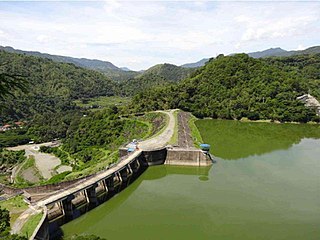
Pantabangan Dam is an earth-fill embankment dam on the Pampanga River located in Pantabangan in Nueva Ecija province of the Philippines. The multi-purpose dam provides water for irrigation and hydroelectric power generation while its reservoir, Pantabangan Lake, affords flood control. The reservoir is considered one of the largest in Southeast Asia and also one of the cleanest in the Philippines. Construction on the dam began in 1971 and it was completed in 1974.
Binga Dam is a dam in Agno River connected to a hydroelectric power plant situated at Barrio Binga, Barangay Tinongdan in the municipality of Itogon in Benguet province of the Philippines.

New Don Pedro Dam, often known simply as Don Pedro Dam, is an earthen embankment dam across the Tuolumne River, about 2 miles (3.2 km) northeast of La Grange, in Tuolumne County, California. The dam was completed in 1971, after four years of construction, to replace the 1924 concrete-arch Don Pedro Dam.

Romulo Highway, also known as Carlos P. Romulo Highway, is a 77.2-kilometer (48.0 mi) major highway in the Philippines that connects the provinces of Tarlac and Pangasinan. It is alternatively known as Tarlac–Pangasinan Road from Tarlac City to Bugallon, Pangasinan and as a component of Pangasinan–Zambales Road and Bugallon–Lingayen Road from Bugallon to Lingayen.

The Pantabangan–Carranglan Watershed Forest Reserve is a conservation area located in the upper reaches of the Pampanga River in Nueva Ecija, Philippines, and borders the Sierra Madre and Caraballo Mountains in Aurora and Nueva Vizcaya. It encompasses 84,500 hectares of the drainage basin surrounding the Pantabangan Lake, an impoundment of the Pampanga River by the Pantabangan Dam. The multi-purpose dam is situated at the confluence of Pampanga River's two headwaters, namely the Pantabangan and Carranglan Rivers in the municipality of Pantabangan. It stretches above the dam site for 21 kilometres (13 mi) to where Carranglan River originates in the Caraballo on the north, and for 18 kilometres (11 mi) to where Pantabangan River originates in the Sierra Madre on the east. It is considered a critical watershed for the agricultural economy and hydroelectric power generation in the region of Central Luzon.

The Upper Agno River Basin Resource Reserve is a protected area located on the southeast flank of the Cordillera Central in the Philippine province of Benguet along its border with Ifugao and Nueva Vizcaya. It is a resource reserve located high in the Central and Polis ranges protecting the headwaters of the Agno River. According to section 4 of the National Integrated Protected Areas System Act, a resource reserve is an extensive and relatively isolated area designated as such to preserve the natural resources of the area. The reserve comprises 77,561 hectares of the catchment area that feeds the Ambuklao and Binga dams, two of the country's oldest hydroelectric plants that supply power to the city of Baguio and entire Benguet province. Upper Agno is north of and contiguous with the Lower Agno Watershed Forest Reserve that preserves the immediate downstream of the Binga Dam where the Agno River is impounded by a third dam, the San Roque Dam, the largest in the Philippines and the main source of water, electric energy and irrigation for surrounding regions in Luzon.

The Lower Agno Watershed Forest Reserve is a Philippine protected area that straddles the Cordillera and Ilocos regions encompassing land from the provinces of Benguet and Pangasinan. Operated by the Lower Agno WFR Protected Area Management Board under the Department of Environment and Natural Resources, Lower Agno follows the Agno River corridor from the northern villages of Itogon to just north of the municipalities of San Manuel and San Nicolas. The reserve also known as the San Roque Watershed protects the mid-Agno River basin with its meandering river and short tributaries in a pine-forested mountainous terrain at the southern end of the Cordillera Central, around 30 kilometres (19 mi) southeast of Baguio. It is located in an important mining district and includes the reservoir of the San Roque Dam, the largest dam in the country and the prime source of water, hydropower and irrigation for surrounding regions in Luzon.