Lower Agno Watershed Forest Reserve

Last updated
Lower Agno Watershed Forest Reserve
IUCN category V (protected landscape/seascape)
Mt. Ulap.jpg
View of the forest reserve in Ampucao, Itogon from the summit of Mount Ulap
Philippines relief location map (Luzon).svg
Red pog.svg
Location in the Philippines
Philippines relief location map (square).svg
Red pog.svg
Lower Agno Watershed Forest Reserve (Philippines)
Location Benguet and Pangasinan, Philippines
Nearest city Baguio
Coordinates 16°16′23″N120°44′51″E / 16.27306°N 120.74750°E / 16.27306; 120.74750 Coordinates: 16°16′23″N120°44′51″E / 16.27306°N 120.74750°E / 16.27306; 120.74750
Area39,304 hectares (97,120 acres)
EstablishedNovember 22, 1983
Governing body Department of Environment and Natural Resources
National Power Corporation
San Roque Power Corporation
National Irrigation Administration

The Lower Agno Watershed Forest Reserve is a Philippine protected area that straddles the Cordillera and Ilocos regions encompassing land from the provinces of Benguet and Pangasinan. Operated by the Lower Agno WFR Protected Area Management Board under the Department of Environment and Natural Resources, Lower Agno follows the Agno River corridor from the northern villages of Itogon to just north of the municipalities of San Manuel and San Nicolas. The reserve also known as the San Roque Watershed protects the mid-Agno River basin with its meandering river and short tributaries in a pine-forested mountainous terrain at the southern end of the Cordillera Central, around 30 kilometres (19 mi) southeast of Baguio. It is located in an important mining district and includes the reservoir of the San Roque Dam, the largest dam in the country and the prime source of water, hydropower and irrigation for surrounding regions in Luzon. [1] [2]

Contents

History

Lower Agno was initially part of the 699,206.09-hectare (1,727,775.9-acre) Central Cordillera Forest Reserve established on February 16, 1929 through Proclamation No. 217 issued by Governor-General Henry L. Stimson, which declared 81.8% of the entire Igorot minority lands in the Cordilleras as protected area. [3] [4] In a 1932 amendment, several parcels of land with an aggregate area of 1,026.8931 hectares (2,537.508 acres) were excluded from the forest reserve and converted into mining areas after 146 mineral claims were approved by Governor Theodore Roosevelt Jr. [5] More areas at the resource-rich forests of the Central Cordillera in Itogon and Tuba were opened up to mining in succeeding years by President Manuel L. Quezon, including 177.1203 hectares (437.674 acres) in the Itogon barrio of Talnag in 1938, 596.8853 hectares (1,474.936 acres) in Tuba and Itogon in 1939, and 17.5547 hectares (43.379 acres) in the barrios of Acupan, Antamok, Chalecno, Gumatdang and Virac in 1941. [6] [7] [8] [9]

The Agno River Development Program was conceived in 1946 as part of the Philippine Power Program under President Manuel Roxas. The program involved the construction of six hydropower facilities along the river, with the first two, the Ambuklao (Agno I) and Binga (Agno II) dams, having been completed in 1956 and 1960 respectively. [10] The Ambuklao-Binga sub-basin was then declared a separate forest reserve in 1966. [11]

The Lower Agno reservation was established on November 22, 1983 as part of the creation of the third dam, the San Roque Dam (Agno V). An initial 39,304 hectares (97,120 acres) of the Cordillera Central Forest Reserve was set aside for water resource protection and conservation by the Ministry of Natural Resources–Bureau of Forest Development, with 9,550 hectares (23,600 acres) reserved for the multi-purpose dam project of the National Power Corporation approved by President Ferdinand Marcos on May 5, 1981. [12] The San Roque Dam eventually began construction in 1998 and was completed on May 1, 2003.

Geography

Dalupirip section of Agno River within the forest reserve in Itogon ITOGON.jpg
Dalupirip section of Agno River within the forest reserve in Itogon

The Lower Agno reserve protects a 34.59-kilometre (21.49 mi)-long valley along the Agno River from just downstream of Binga Dam in the mountain village of Tinongdan to the foothills and alluvial plains of San Roque in San Manuel immediately below the San Roque dam and reservoir. The 39,304-hectare (97,120-acre) reservation is located primarily in Itogon in the southern Cordillera Central, with small areas extending westward into Baguio and Tuba and southward into San Roque village, San Manuel and San Felipe East in San Nicolas. [1] About 90 percent of the total land area of Itogon lies within the reservation. [13]

The protected area has a mean elevation of 889.33 metres (2,917.7 ft) with peaks rising to 2,164.60 metres (7,101.7 ft) above sea level. [14] Its highest point is Mount Ugo situated at its northeastern end. To the west, the valley is flanked by a sub-chain of the Cordillera Central that includes the 1,829-metre (6,001 ft) high Mount Ulap and the 1,334-metre (4,377 ft) high Mount Kotkot that separate it from the Bued River basin of Tuba. Other prominent peaks in the reserve include the 1,328 metres (4,357 ft) Mount Pigingan, Mount Ave Maria (Bidawan) and Mount Marikit. [15] Its lowest point is the San Roque Dam site at 100 metres (330 ft).

The reserve is one of six protected areas located in the 623,318.69-hectare (1,540,254.0-acre) Agno River Basin, the third largest river system in Luzon and the Philippines' fifth largest. [14] [16] It is a sub-catchment of the Agno River which drains into the Lingayen Gulf from its headwaters at Mount Data further north. Its main tributary within the reservation is Twin River at its northern portion which has its source in the peaks around Baguio and which splits into several streams in the Gumatdang mining village, including the Ambalanga River, Liang Creek and Batuang Creek. [17] The central and southern sections of the reserve are fed by other branches of the Agno River, namely the Laboy and Ambayoan rivers as well as several streams in the Padcal mining area of Ampucao and Dalupirip villages including Balog River, Albian Creek, Manaa and Salangan Creek. [14] [2]

The geology of Lower Agno WFR is characterized as predominantly mountain type dominated by undifferentiated and igneous intrusive rocks from the Miocene and Pliocene periods with minor outcrops of sedimentary and metamorphic rocks. It has pockets of silt, sandy and clay loam near its reservoir in Pangasinan. [14]

An irrigation canal just below the San Roque Dam in Narra, San Manuel 455Narra San Roque, San Manuel, Pangasinan 35.jpg
An irrigation canal just below the San Roque Dam in Narra, San Manuel

Lower Agno is bounded to the west by both operating and abandoned gold and copper mining areas. Mining activities have been conducted in the area since 1906 with the opening of Benguet Corp.'s Acupan Mine. The gold mining company also operates the Antamok, Baco and Kelly sites along the Ambalanga River just east of Baguio and the Balatoc Mill. The Agno tributary of Ambalanga is also the site of the Itogon Mine of Itogon-Suyoc company which opened in 1926. South of these gold mines along the Albian and Manaa creeks are the Santo Tomas (Padcal) copper mines of Philex Mining Corp. which began operations in 1958. [2]

The reservation is in the ancestral domain of the Kalanguya, Ibaloy and Iwaak minorities. [14]

Ecology

Pinus kesiya foliage at Mount Ugo Pinus kesiya foliage MtUgo.jpg
Pinus kesiya foliage at Mount Ugo

Lower Agno is part of the Central Cordillera Terrestrial Biogeographic Region and contains mossy and tropical subalpine forests, second-growth tropical lower montane forests, grasslands and agricultural lands in lower elevations. [14] The Pinus kesiya (Benguet pine) is the most dominant vegetation in the tropical subalpine forests of the reserve. [14]

Lower Agno is a habitat of the Philippine deer, Philippine long-tailed macaque, Philippine warty pig, Northern Luzon giant cloud rat, Philippine cobra, monitor lizard and Malayan civet. [14] At least eleven raptors have been documented in the reserve, including the Philippine hawk-eagle, eastern osprey, brahminy kite, Philippine serpent eagle, white-bellied sea eagle, rufous-bellied eagle, black-shouldered kite, crested honey buzzard, barred honey buzzard and Philippine falconet. [18]


Related Research Articles

Baguio City in Cordillera Region, northern Philippines

Baguio, officially known as the City of Baguio, is a 1st class highly urbanized city in the Cordillera Administrative Region, Philippines. It is known as the "Summer Capital of the Philippines", owing to its cool climate since the city is located approximately 4,810 feet above mean sea level, often cited as 1,540 meters in the Luzon tropical pine forests ecoregion, which also makes it conducive for the growth of mossy plants, orchids and pine trees, to which it attributes its other moniker as the "City of Pines".

Benguet Province in Cordillera Administrative Region, Philippines

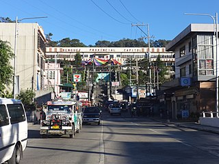
Benguet, officially the Province of Benguet, is a landlocked province of the Philippines located in the southern tip of the Cordillera Administrative Region in the island of Luzon. Its capital is La Trinidad.

Cordillera Administrative Region Administrative region of the Philippines

Cordillera Administrative Region (CAR), also known as Cordillera Region, is an administrative region in the Philippines, situated within the island of Luzon. It is the only landlocked region in the insular country, bordered by the Ilocos Region to the west and southwest, and by the Cagayan Valley Region to the north, east, and southeast. It is the least populous region in the Philippines, with a population less than that of the city of Manila.

Cordillera Central (Luzon) Mountain range in Luzon, Philippines

The Cordillera Central or Cordillera Range is a massive mountain range 320 km long north-south and 118 km east-west. The Cordillera mountain range is situated in the north-central part of the island of Luzon, in the Philippines. The mountain range encompasses all provinces of the Cordillera Administrative Region, as well as portions of eastern Ilocos Norte, eastern Ilocos Sur, eastern La Union, northeastern Pangasinan, western Nueva Vizcaya, and western Cagayan.

La Trinidad, Benguet Municipality in Cordillera Administrative Region, Philippines

La Trinidad, officially the Municipality of La Trinidad, is a 1st class municipality and capital of the province of Benguet, Philippines. According to the 2020 census, it has a population of 137,404 people. 

Itogon Municipality in Cordillera Administrative Region, Philippines

Itogon, officially the Municipality of Itogon,, is a 1st class municipality in the province of Benguet, Philippines. According to the 2020 census, it has a population of 61,498 people. 

Tuba, Benguet Municipality in Cordillera Administrative Region, Philippines

Tuba, officially the Municipality of Tuba,, is a 1st class municipality in the province of Benguet, Philippines. According to the 2020 census, it has a population of 48,312 people. 

Agno River River in the Cordilleras and Ilocos Regions, Philippines

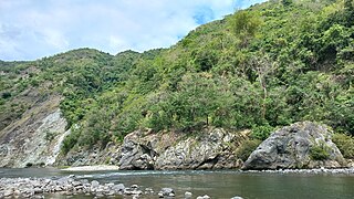
The Agno River, or Pangasinan River, is a river in the island of Luzon, in the Philippines. Traversing the provinces of Benguet and Pangasinan, it is one of the largest river systems in the country, with a drainage area of 5,952 square kilometres (2,298 sq mi).

The San Roque Dam, operated under San Roque Multipurpose Project (SRMP) is a 200-meter-tall, 1.2 kilometer long embankment dam on the Agno River. It is the largest dam in the Philippines and sixteenth largest in the world. It spans the municipalities of San Manuel and San Nicolas, Pangasinan, nearly 200 km north of Metro Manila.

Ambuklao Dam Dam in Bokod, Benguet

Ambuklao Dam is part of a hydroelectric facility in Baragay Ambuclao, Bokod, Benguet province in the Philippines. With a maximum water storage capacity of 327,170,000 cubic metres (265,240 acre⋅ft), the facility, which is located 36 km (22 mi) from Baguio city, can produce up to 105 megawatts of electricity to the Luzon grid. The main source of water comes from the Agno River, which originates from Mount Data. The dam is located in a conservation area known as the Upper Agno River Basin Resource Reserve.

Binga Dam Dam in Itogon, Benguet

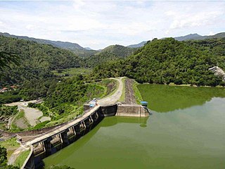
Binga Dam is a dam in Agno River connected to a hydroelectric power plant situated at Barrio Binga, Barangay Tinongdan in the municipality of Itogon in Benguet province of the Philippines.

Metro Baguio Metropolitan Area in Philippines

BLISTT is an agglomeration of the city of Baguio and five municipalities of the province of Benguet, namely: La Trinidad, Itogon, Sablan, Tuba, and Tublay.

Benguet Corporation

Benguet Corporation is a diversified Philippine business enterprise.

Mount Data

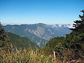
Mount Data is a mountain located in the Cordillera Central mountain range rising to a height of 2,310 metres (7,580 ft) in the north of Luzon Island, Philippines. It is about 100 kilometres (62 mi) north of Baguio on the borders of the provinces of Benguet and Mountain Province along the Halsema Highway. The mountain and surrounding area has been declared a national park since 1936. In 1940 the park was expanded to 5,513 hectares. The slopes of the mountain are covered with pine forests and mossy oak forests.

The Baguio–Bua–Itogon National Road is a major highway in northern Luzon that runs from the city of Baguio to the municipality of Itogon in the province of Benguet.

Mounts Banahaw–San Cristobal Protected Landscape

Mounts Banahaw–San Cristobal Protected Landscape is a protected landscape park in the Calabarzon region of the Philippines, 120 kilometres (75 mi) south of Manila. It is the second largest protected area in Calabarzon, after the Upper Marikina River Basin Protected Landscape, with an area of 10,900.59 hectares. The park is located at the border of Laguna and Quezon provinces and includes the features it is named after: Mount Banahaw and, 7 kilometres (4.3 mi) to its west, Mount San Cristobal.

The Benguet–Nueva Vizcaya Road,, is the road system that connects the provinces of Benguet and Nueva Vizcaya in the Philippines.

Angat Watershed Forest Reserve

The Angat Watershed Forest Reserve is a conservation area that protects the drainage basin in the southern Sierra Madre range north of Metro Manila in the Philippines where surface water empties into the Angat River and its distributaries. It is spread over an area of 62,309 hectares in the eastern portion of Bulacan and northern Rizal province at an altitude of between 490 and 1,206 metres. The conservation area also extends to the provinces of Nueva Ecija and Quezon and is centered on an artificial lake created by the Angat Dam which, together with the Ipo Dam located 7.5 kilometres (4.7 mi) downstream, supply 97% of the water requirement of Metro Manila via an aqueduct system to the La Mesa Dam and Reservoir and the Balara Filtration Plant in Quezon City. The Angat Dam and Reservoir is also a major source of hydroelectricity for Metro Manila and surrounding provinces, contributing some 200 megawatts to the Luzon grid. The watershed is a popular birdwatching site and is a biodiversity hotspot containing most of the remaining closed-canopy forests in Central Luzon.

Pantabangan–Carranglan Watershed Forest Reserve

The Pantabangan–Carranglan Watershed Forest Reserve is a conservation area located in the upper reaches of the Pampanga River in Nueva Ecija, Philippines, and borders the Sierra Madre and Caraballo Mountains in Aurora and Nueva Vizcaya. It encompasses 84,500 hectares of the drainage basin surrounding the Pantabangan Lake, an impoundment of the Pampanga River by the Pantabangan Dam. The multi-purpose dam is situated at the confluence of Pampanga River's two headwaters, namely the Pantabangan and Carranglan Rivers in the municipality of Pantabangan. It stretches above the dam site for 21 kilometres (13 mi) to where Carranglan River originates in the Caraballo on the north, and for 18 kilometres (11 mi) to where Pantabangan River originates in the Sierra Madre on the east. It is considered a critical watershed for the agricultural economy and hydroelectric power generation in the region of Central Luzon.

Upper Agno River Basin Resource Reserve

The Upper Agno River Basin Resource Reserve is a protected area located on the southeast flank of the Cordillera Central in the Philippine province of Benguet along its border with Ifugao and Nueva Vizcaya. It is a resource reserve located high in the Central and Polis ranges protecting the headwaters of the Agno River. According to section 4 of the National Integrated Protected Areas System Act, a resource reserve is an extensive and relatively isolated area designated as such to preserve the natural resources of the area. The reserve comprises 77,561 hectares of the catchment area that feeds the Ambuklao and Binga dams, two of the country's oldest hydroelectric plants that supply power to the city of Baguio and entire Benguet province. Upper Agno is north of and contiguous with the Lower Agno Watershed Forest Reserve that preserves the immediate downstream of the Binga Dam where the Agno River is impounded by a third dam, the San Roque Dam, the largest in the Philippines and the main source of water, electric energy and irrigation for surrounding regions in Luzon.

References

  1. 1 2 "Proclamation No. 2320, s. 1983". Official Gazette (Philippines) . Retrieved October 1, 2020.
  2. 1 2 3 "Re-Study of the San Roque Multi-Purpose Project" (PDF). Japan International Cooperation Agency. September 1985. Retrieved October 1, 2020.
  3. Bureau of Forestry (1933). Annual Report of the Director of Forestry. Florencio Tamesis, Director of Forestry. Manila: Bureau of Printing. p. 142. Retrieved October 1, 2020.
  4. Friedrich-Ebert-Stiftung (1989). Towards Understanding the Cordillera Autonomous Region. Maximo B. Garming. Manila: Friedrich-Ebert-Stiftung. p. 6. Retrieved October 1, 2020.
  5. Bureau of Forestry (1933). Annual Report of the Director of Forestry. Florencio Tamesis, Director of Forestry. Manila: Bureau of Printing. p. 64. Retrieved October 1, 2020.
  6. "Proclamation No. 271, s. 1938". Official Gazette (Philippines) . Retrieved October 1, 2020.
  7. "Proclamation No. 385, s. 1939". Official Gazette (Philippines) . Retrieved October 1, 2020.
  8. "Proclamation No. 795, s. 1941". Official Gazette (Philippines) . Retrieved October 1, 2020.
  9. "Proclamation No. 749, s. 1941". Official Gazette (Philippines) . Retrieved October 1, 2020.
  10. Cordillera People's Alliance, Public Information Commission. "Dams in the Cordillera" (PDF). International Rivers . Retrieved October 1, 2020.
  11. "Proclamation No. 120, s. 1966". Official Gazette (Philippines) . Retrieved October 1, 2020.
  12. "Executive Order No. 687, s. 1981". Official Gazette (Philippines) . Retrieved October 1, 2020.
  13. Quitasol, K. (September 13, 2015). "Mining town seeks watershed exclusion". Philippine Daily Inquirer . Retrieved October 1, 2020.
  14. 1 2 3 4 5 6 7 8 College of Forestry and Natural Resources University of the Philippines Los Baños. "Climate-Responsive Integrated Master Plan for Agno River Basin" (PDF). Department of Environment and Natural Resources . Retrieved October 1, 2020.
  15. "Benguet Mountains". PeakVisor. Retrieved October 1, 2020.
  16. "The Agno River Basin". ABS-CBN News. October 23, 2009. Retrieved October 1, 2020.
  17. Graduate School of Arts and Sciences (1971). St. Louis University Research Journal Volume 2. Baguio: Saint Louis University (Philippines). pp. 520–521. Retrieved October 1, 2020.
  18. Cardinoza, G. (June 25, 2013). "Luzon watershed offers home to Philippine eagle". Philippine Daily Inquirer . Retrieved October 1, 2020.