Upper Agno River Basin Resource Reserve

Last updated
Upper Agno River Basin Resource Reserve
IUCN category VI (protected area with sustainable use of natural resources)
Ambuklao Dam.jpg
View of the reserve surrounding the Ambuklao Dam and reservoir in Bokod
Philippines relief location map (Luzon).svg
Red pog.svg
Location in the Philippines
Philippines relief location map (square).svg
Red pog.svg
Upper Agno River Basin Resource Reserve (Philippines)
Location Benguet, Philippines
Nearest city Baguio
Coordinates 16°27′29″N120°44′28″E / 16.45806°N 120.74111°E / 16.45806; 120.74111 Coordinates: 16°27′29″N120°44′28″E / 16.45806°N 120.74111°E / 16.45806; 120.74111
Area77,561 hectares (191,660 acres)
EstablishedNovember 25, 1966 (forest reserve)
April 23, 2000 (resource reserve)
Governing body Department of Environment and Natural Resources
National Power Corporation
SN Aboitiz

The Upper Agno River Basin Resource Reserve is a protected area located on the southeast flank of the Cordillera Central in the Philippine province of Benguet along its border with Ifugao and Nueva Vizcaya. It is a resource reserve located high in the Central and Polis ranges protecting the headwaters of the Agno River. According to section 4 of the National Integrated Protected Areas System Act (R.A. 7586), a resource reserve is an extensive and relatively isolated area designated as such to preserve the natural resources of the area. [1] The reserve comprises 77,561 hectares (191,660 acres) of the catchment area that feeds the Ambuklao and Binga dams, two of the country's oldest hydroelectric plants that supply power to the city of Baguio and entire Benguet province. [2] Upper Agno is north of and contiguous with the Lower Agno Watershed Forest Reserve that preserves the immediate downstream of the Binga Dam where the Agno River is impounded by a third dam, the San Roque Dam, the largest in the Philippines and the main source of water, electric energy and irrigation for surrounding regions in Luzon. [3] [4]

Contents

History

The area of the Upper Agno river basin first achieved official park protection on February 16, 1929 when Governor-General Henry L. Stimson signed Proclamation No. 217 declaring 81.8% of the entire Cordillera Central range as the Central Cordillera Forest Reserve. [5] [6] Through an amendment to the law made in 1932 by Governor-General Theodore Roosevelt Jr., the reserve lost 1,026.8931 hectares (2,537.508 acres) of fragmented lands to mining concessions. [7] When President Manuel L. Quezon signed Proclamation No. 65 in 1936, a portion of the basin surrounding Mount Data was re-gazetted as part of the 2,398-hectare (5,930-acre) Baguio–Bontoc Scenic National Park. [8] The national park was expanded to 5,512 hectares (13,620 acres) and was renamed Mount Data National Park in 1940. [9]

In 1946, the Agno River Development Program was launched to construct six hydropower facilities along the Agno River. [10] The Ambuklao Dam was built in 1956 while the second facility, the Binga Dam, was completed in 1960. On November 25, 1966, President Ferdinand Marcos issued Proclamation No. 120 declaring the immediate upstream and downstream of the Ambuklao Dam including a portion of the Mount Data National Park traversed by the Agno River as part of a new protected area, the 9,700-hectare (24,000-acre) Ambuklao Watershed Forest Reserve. [11] In 1987, a portion of the forest reserve containing Luzon's highest peak, Mount Pulag, Mount Tabeyoc, Mount Panotoan and four other adjacent peaks were set aside as the Mount Pulag National Park. [12]

On April 23, 2000 through the issuance of Proclamation No. 268, the reserve was consolidated as a resource reserve and was significantly expanded to 77,561 hectares (191,660 acres) to cover the entire upper Agno river basin bordering the Mount Data and Mount Pulag national parks. [3]

Geography

The Upper Agno reserve protects the northernmost 45.94 km (28.55 mi) section of the Agno River from the Mount Data National Park in Buguias to Binga Dam in Itogon. [13] It is located to the east and north of the city of Baguio in the southern Cordillera Central mountains and covers the catchment area between the ridges of the Central and Polis ranges. The majority of the reserve is in Benguet shared by the municipalities of Atok, Bokod, Buguias, Itogon, Kabayan, Kibungan, La Trinidad and Tublay. It also has a sizeable area in Ifugao split between the towns of Hungduan and Kiangan and a small part in Nueva Vizcaya in the town of Kayapa. [3]

Bokod River in Karao, a tributary of the Upper Agno River Fvf0241 18.JPG
Bokod River in Karao, a tributary of the Upper Agno River

The Upper Agno River Basin is the third largest sub-catchment in the entire Agno River Basin that spans three regions in northern Luzon. Its main tributaries are the 110 km (68 mi) long Bokod River which empties into it at the Ambuklao reservoir from the east, the Benneng River which flows 121 km (75 mi) on the east side between the Ambuklao and Binga dams, and the 47 km (29 mi) long Bantay River located upstream of Ambuklao Dam. [14] The reserve is also fed by several other smaller streams including Karao River in Bokod, and Eddet and Adaoay rivers in Kabayan. [15]

Upper Agno is one of the highest protected areas in the country. It has an average elevation of 1,604.97 metres (5,265.6 ft), the highest among the nineteen Agno river sub-basins. [13] Mount Mongawto (Mongoto) is the highest point in the reserve at 2,720 m (8,920 ft) situated in the Central range within the municipality of Atok. [16] Halsema Highway (Baguio–Bontoc Road), the country's highest paved national road, runs through the reserve's western boundaries. Nine other mountain peaks over 7,000 feet (2,100 m) high provide scenic vistas, including Mount Nangaoto (8,386 ft (2,556 m), Mount Singakalsa (8,104 ft (2,470 m), Mount Aki (7,723 ft (2,354 m), Mount Ambubungan (7,405 ft (2,257 m), Mount Palugloko (7,359 ft (2,243 m), Mount Toyangan (7,238 ft (2,206 m), Mount Bayoyo (7,185 ft (2,190 m) and Mount Palansa (7,119 ft (2,170 m). [16] This area experiences regular hailstorms and some of the coolest weather in the Philippines. [17]

Ambuklao Lake Ambuklao Lake.jpg
Ambuklao Lake

The focal point of the reserve is the Ambuklao Dam and reservoir situated on the confluence of the Agno and Bokod rivers in the southern portion of the reserve. It is the oldest hydropower dam in the country built in 1956 with a reservoir capacity of 329,000,000 cubic metres (1.16×10¹⁰ cu ft) that supplied 75 megawatts (increased to 105 MW when it was rehabilitated in 2011) to the Luzon grid. [14] Located 19 km (12 mi) downstream of Ambuklao at the southern edge of the reserve is the Binga Dam and reservoir built in 1960 that has a capacity of 87,000,000 cubic metres (3.1×10⁹ cu ft) and maximum output of 100 megawatts. [14]

Ecology

Philippine thistle (Cirsium luzoniense), an endemic ornamental plant found in the mossy forests of Bokod Tumtumbok of Mt. Purgatory.jpg
Philippine thistle (Cirsium luzoniense), an endemic ornamental plant found in the mossy forests of Bokod

The ecology of the Upper Agno reserve varies from lower montane forests, upper montane forests to grassland summits. The most dominant vegetation in the lower montane forests are the Benguet pine ( Pinus kesiya ), evergreen shrubs ( Gaultheria borneensis) and makole flowering plants ( Coprosma granadensis). [13] In slopes above 2,000 m (6,600 ft), the mossy forests primarily contain woody plants belonging to the Ericaceae family such as Rhododendron taxifolium, Rhododendron subsessile, Vaccinium myrtoides and Vaccinium indutum. Above the upper montane forests that cover the summits of the highest peaks are grasslands dominated by dwarf bamboo ( Yushania niitikayamensis) as well as heathgrass ( Danthonia oreoboloides), reedgrass ( Deyeuxia suizanensis), Pulag St. Johnswort ( Hypericum pulogense) and ( Trichophorum subcapitatum). [13] An endemic ornamental begonia, Begonia merrittii, is also known to occur in high elevation habitats of Upper Agno. [18] A new species of endemic orchids, Dendrochilum ignisiflorum , has also been documented in the mossy forest around the summit of the 2,300-metre (7,500 ft) high Mount Komkompol in Bokod in 2020. [19]

At least 70 bird species have been sighted or recorded within the protected area, 46 of which are endemic to the Philippines, including the scale-feathered malkoha, mountain shrike, indigo-banded kingfisher, bicolored flowerpecker, balicassiao, flame-breasted fruit dove, Philippine coucal, Philippine scops owl, white-browed jungle flycatcher, blue-headed fantail, lovely sunbird, Luzon striped babbler, Northern Luzon dark-throated oriole and whiskered pitta. [13] Its mammalian wildlife species include the Asian palm civet, Malayan civet, Philippine long-tailed macaque, Northern Luzon giant cloud rat, Mount Data shrew-rat, Luzon shrew, large flying fox, Philippine warty pig and Philippine deer. [13]

The Upper Agno river and its tributaries have the highest fish diversity among the five river systems in Benguet. [15] Fish species found in these rivers include Java fat-nose goby, mangrove flathead goby, giant mottled eel, pond loach and mosquitofish. The Ambuklao reservoir is stocked abundantly with introduced fish species, namely silver perch, Celebes goby, common carp, silver carp, bighead carp and tilapia. It also has commercially abundant freshwater shrimp and Asiatic clam. [15] The Ambuklao reservoir also supports aquaculture and has at least 83 fish cage operators harvesting crimson snapper, tilapia and silver carp within the permitted 6.8-hectare (17-acre) fishing zone of the more than 400 ha (990-acre) artificial lake since 1994. [20]

Recreation

Nestled between Mount Pulag and Mount Ugo just east of the Ambuklao lake in Bokod is an ecologically significant hiking mountain circuit destination with peaks rising above 2,000 m (6,600 ft). [21] The Mount Purgatory (Mangisi) Ecotourism Circuit is made up of seven mountain peaks, the highest of which are Mount Komkompol and Mount Pack, which are accessible by a 10.5 km (6.5 mi) and 15.5 km (9.6 mi) designated foot trails through long stretches of dense mossy forests, pine trees and grasslands. [22] [23]

Related Research Articles

Cagayan River Longest river in the Philippines

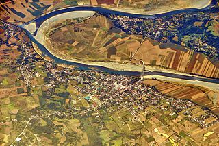
The Cagayan River, also known as the Río Grande de Cagayán, is the longest river and the largest river by discharge volume of water in the Philippines. It has a total length of approximately 505 kilometres (314 mi) and a drainage basin covering 27,753 square kilometres (10,715 sq mi). It is located in the Cagayan Valley region in northeastern part of Luzon Island and traverses the provinces of Nueva Vizcaya, Quirino, Isabela and Cagayan.

Benguet Province in Cordillera Administrative Region, Philippines

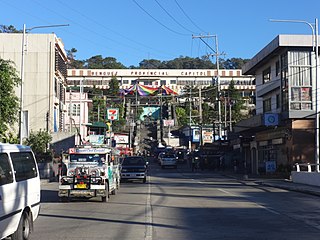
Benguet, officially the Province of Benguet, is a landlocked province of the Philippines located in the southern tip of the Cordillera Administrative Region in the island of Luzon. Its capital is La Trinidad.

Cordillera Administrative Region Administrative region of the Philippines

Cordillera Administrative Region (CAR), also known as Cordillera Region, is an administrative region in the Philippines, situated within the island of Luzon. It is the only landlocked region in the insular country, bordered by the Ilocos Region to the west and southwest, and by the Cagayan Valley Region to the north, east, and southeast. It is the least populous region in the Philippines, with a population less than that of the city of Manila.

Cordillera Central (Luzon) Mountain range in Luzon, Philippines

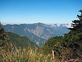
The Cordillera Central or Cordillera Range is a massive mountain range 320 km long north-south and 118 km east-west. The Cordillera mountain range is situated in the north-central part of the island of Luzon, in the Philippines. The mountain range encompasses all provinces of the Cordillera Administrative Region, as well as portions of eastern Ilocos Norte, eastern Ilocos Sur, eastern La Union, northeastern Pangasinan, western Nueva Vizcaya, and western Cagayan.

Mount Pulag Volcano in the Philippines

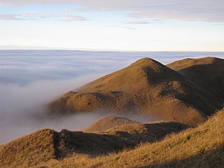
Mount Pulag is Luzon's highest peak at 2,928 metres (9,606 ft) above sea level, third-highest mountain in the Philippines, and the 26th-highest peak of an island on Earth. It is second-most prominent mountain in the Philippines, it is a dormant volcano. Located on the triple border of the provinces of Benguet, Ifugao, and Nueva Vizcaya, the borders meet at the mountain's peak. Mount Pulag is third highest next to Mount Apo and Mount Dulang-dulang.

Ibaloi people Indigenous ethnic group found in Benguet Province of the northern Philippines

The Ibaloi are an indigenous ethnic group found in Benguet Province of the northern Philippines. Ibaloi is derived from i-, a prefix signifying "pertaining to" and badoy or house, together then meaning "people who live in houses". The Ibaloi are one of the indigenous peoples collectively known as Igorot, who live in the cordillera central of Luzón.

Igorot people Ethnic group in the Philippines

The indigenous peoples of the Cordillera Mountain Range of northern Luzon, Philippines are often referred to using the exonym Igorot people, or more recently, as the Cordilleran peoples. There are nine main ethnolinguistic groups whose domains are in the Cordillera Mountain Range, altogether numbering about 1.5 million people in the early 21st century.

Bokod, Benguet Municipality in Cordillera Administrative Region, Philippines

Bokod, officially the Municipality of Bokod,, is a 4th class municipality in the province of Benguet, Philippines. According to the 2020 census, it has a population of 14,435 people. 

Itogon Municipality in Cordillera Administrative Region, Philippines

Itogon, officially the Municipality of Itogon,, is a 1st class municipality in the province of Benguet, Philippines. According to the 2020 census, it has a population of 61,498 people. 

Kabayan, Benguet Municipality in Cordillera Administrative Region, Philippines

Kabayan, officially the Municipality of Kabayan, is a 4th class municipality in the province of Benguet, Philippines. According to the 2020 census, it has a population of 15,806 people. 

Agno River River in the Cordilleras and Ilocos Regions, Philippines

The Agno River, or Pangasinan River, is a river in the island of Luzon, in the Philippines. Traversing the provinces of Benguet and Pangasinan, it is one of the largest river systems in the country, with a drainage area of 5,952 square kilometres (2,298 sq mi).

The San Roque Dam, operated under San Roque Multipurpose Project (SRMP) is a 200-meter-tall, 1.2 kilometer long embankment dam on the Agno River. It is the largest dam in the Philippines and sixteenth largest in the world. It spans the municipalities of San Manuel and San Nicolas, Pangasinan, nearly 200 km north of Metro Manila.

Ambuklao Dam Dam in Bokod, Benguet

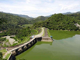
Ambuklao Dam is part of a hydroelectric facility in Baragay Ambuclao, Bokod, Benguet province in the Philippines. With a maximum water storage capacity of 327,170,000 cubic metres (265,240 acre⋅ft), the facility, which is located 36 km (22 mi) from Baguio city, can produce up to 105 megawatts of electricity to the Luzon grid. The main source of water comes from the Agno River, which originates from Mount Data. The dam is located in a conservation area known as the Upper Agno River Basin Resource Reserve.

Binga Dam Dam in Itogon, Benguet

Binga Dam is a dam in Agno River connected to a hydroelectric power plant situated at Barrio Binga, Barangay Tinongdan in the municipality of Itogon in Benguet province of the Philippines.

Luzon tropical pine forests

The Luzon tropical pine forests are a tropical coniferous forest ecoregion of the Philippines in the western Pacific Ocean. These pine forests are home to a large number of the island's endemic plants and animals.

Mount Data

Mount Data is a mountain located in the Cordillera Central mountain range rising to a height of 2,310 metres (7,580 ft) in the north of Luzon Island, Philippines. It is about 100 kilometres (62 mi) north of Baguio on the borders of the provinces of Benguet and Mountain Province along the Halsema Highway. The mountain and surrounding area has been declared a national park since 1936. In 1940 the park was expanded to 5,513 hectares. The slopes of the mountain are covered with pine forests and mossy oak forests.

The Benguet–Nueva Vizcaya Road,, is the road system that connects the provinces of Benguet and Nueva Vizcaya in the Philippines.

Angat Watershed Forest Reserve

The Angat Watershed Forest Reserve is a conservation area that protects the drainage basin in the southern Sierra Madre range north of Metro Manila in the Philippines where surface water empties into the Angat River and its distributaries. It is spread over an area of 62,309 hectares in the eastern portion of Bulacan and northern Rizal province at an altitude of between 490 and 1,206 metres. The conservation area also extends to the provinces of Nueva Ecija and Quezon and is centered on an artificial lake created by the Angat Dam which, together with the Ipo Dam located 7.5 kilometres (4.7 mi) downstream, supply 97% of the water requirement of Metro Manila via an aqueduct system to the La Mesa Dam and Reservoir and the Balara Filtration Plant in Quezon City. The Angat Dam and Reservoir is also a major source of hydroelectricity for Metro Manila and surrounding provinces, contributing some 200 megawatts to the Luzon grid. The watershed is a popular birdwatching site and is a biodiversity hotspot containing most of the remaining closed-canopy forests in Central Luzon.

Pantabangan–Carranglan Watershed Forest Reserve

The Pantabangan–Carranglan Watershed Forest Reserve is a conservation area located in the upper reaches of the Pampanga River in Nueva Ecija, Philippines, and borders the Sierra Madre and Caraballo Mountains in Aurora and Nueva Vizcaya. It encompasses 84,500 hectares of the drainage basin surrounding the Pantabangan Lake, an impoundment of the Pampanga River by the Pantabangan Dam. The multi-purpose dam is situated at the confluence of Pampanga River's two headwaters, namely the Pantabangan and Carranglan Rivers in the municipality of Pantabangan. It stretches above the dam site for 21 kilometres (13 mi) to where Carranglan River originates in the Caraballo on the north, and for 18 kilometres (11 mi) to where Pantabangan River originates in the Sierra Madre on the east. It is considered a critical watershed for the agricultural economy and hydroelectric power generation in the region of Central Luzon.

Lower Agno Watershed Forest Reserve

The Lower Agno Watershed Forest Reserve is a Philippine protected area that straddles the Cordillera and Ilocos regions encompassing land from the provinces of Benguet and Pangasinan. Operated by the Lower Agno WFR Protected Area Management Board under the Department of Environment and Natural Resources, Lower Agno follows the Agno River corridor from the northern villages of Itogon to just north of the municipalities of San Manuel and San Nicolas. The reserve also known as the San Roque Watershed protects the mid-Agno River basin with its meandering river and short tributaries in a pine-forested mountainous terrain at the southern end of the Cordillera Central, around 30 kilometres (19 mi) southeast of Baguio. It is located in an important mining district and includes the reservoir of the San Roque Dam, the largest dam in the country and the prime source of water, hydropower and irrigation for surrounding regions in Luzon.

References

  1. "Republic Act No. 7586". Official Gazette (Philippines) . Retrieved October 1, 2020.
  2. Caluza, D. (October 28, 2013). "Upgrading of Luzon dams to cost P54B". Philippine Daily Inquirer . Retrieved October 1, 2020.
  3. 1 2 3 "Proclamation No. 268, s. 2000". Official Gazette (Philippines) . Retrieved October 1, 2020.
  4. "Re-Study of the San Roque Multi-Purpose Project" (PDF). Japan International Cooperation Agency. September 1985. Retrieved October 1, 2020.
  5. Bureau of Forestry (1933). Annual Report of the Director of Forestry. Florencio Tamesis, Director of Forestry. Manila: Bureau of Printing. p. 142. Retrieved October 1, 2020.
  6. Friedrich-Ebert-Stiftung (1989). Towards Understanding the Cordillera Autonomous Region. Maximo B. Garming. Manila: Friedrich-Ebert-Stiftung. p. 6. Retrieved October 1, 2020.
  7. Bureau of Forestry (1933). Annual Report of the Director of Forestry. Florencio Tamesis, Director of Forestry. Manila: Bureau of Printing. p. 64. Retrieved October 1, 2020.
  8. "Proclamation No. 65, s. 1936". Official Gazette (Philippines) . Retrieved October 1, 2020.
  9. "Proclamation No. 634, s. 1940". Official Gazette (Philippines) . Retrieved October 1, 2020.
  10. Cordillera People's Alliance, Public Information Commission. "Dams in the Cordillera" (PDF). International Rivers . Retrieved October 1, 2020.
  11. "Proclamation No. 120, s. 1966". Official Gazette (Philippines) . Retrieved October 1, 2020.
  12. "Proclamation No. 75, s. 1987". Official Gazette (Philippines) . Retrieved October 1, 2020.
  13. 1 2 3 4 5 6 College of Forestry and Natural Resources University of the Philippines Los Baños. "Climate-Responsive Integrated Master Plan for Agno River Basin" (PDF). Department of Environment and Natural Resources . Retrieved October 1, 2020.
  14. 1 2 3 "Ilog Itaas ng Agno" (PDF). Kyoto University . Retrieved October 1, 2020.
  15. 1 2 3 Napaldet, J.T. (January 2018). "Fishes and Shell Diversity in Major Rivers of Benguet, Philippines" . Retrieved October 1, 2020.
  16. 1 2 "Upper Agno River Basin". PeakVisor. Retrieved October 1, 2020.
  17. Canlas, KC (April 26, 2020). "Winter is coming? Benguet experiences a cool and 'icy' summer". When In Manila . Retrieved October 1, 2020.
  18. Rivera-Rubite, R.R. "Begonia section Pettermania of Luzon Island, the Philippines" (PDF). Department of Science and Technology (Philippines) . Retrieved October 1, 2020.
  19. Tamayo, M.N.; Pranada, A.K.; Bustamante, R.A. "Dendrochilum ignisiflorum (Coelogyninae, Arethuseae, Orchidaceae), a new species from Luzon Island, Philippines". Biotaxa. Retrieved October 1, 2020.
  20. Cabreza, V. (July 31, 2011). "Benguet village discovers new economy as hydro dam is reborn". Philippine Daily Inquirer . Retrieved October 1, 2020.
  21. Lasco, G. (January 1, 2013). "Mt. Purgatory Traverse/Mt. Pack-Mt. Komkompol (2,290/2,329+)". Pinoy Mountaineer. Retrieved October 1, 2020.
  22. "Mount Purgatory Mangisi" (PDF). Jaime V. Ongpin Foundation. Retrieved October 1, 2020.
  23. Likigan, L. "Mountain hopping in Benguet". Baguio Midland Courier. Retrieved October 1, 2020.