Kabayan | |
---|---|
Municipality of Kabayan | |
Location within the Philippines | |
Coordinates: 16°37′24″N120°50′17″E / 16.6233°N 120.8381°E | |
Country | Philippines |
Region | Cordillera Administrative Region |
Province | Benguet |
District | Lone district |
Barangays | 13 (see Barangays) |
Government | |
• Type | Sangguniang Bayan |
• Mayor | Florante B. Bantales Jr. |
• Vice Mayor | Mike E. Badival |
• Representative | Eric Go Yap |
• Electorate | 10,092 voters (2022) |
Area | |
• Total | 242.69 km2 (93.70 sq mi) |
Elevation | 1,613 m (5,292 ft) |
Highest elevation | 2,688 m (8,819 ft) |
Lowest elevation | 932 m (3,058 ft) |
Population (2020 census) [3] | |
• Total | 15,806 |
• Density | 65/km2 (170/sq mi) |
• Households | 3,752 |
Economy | |
• Income class | 4th municipal income class |
• Poverty incidence | 19.14 |
• Revenue | ₱ 116.2 million (2020) |
• Assets | ₱ 231.1 million (2020) |
• Expenditure | ₱ 92.33 million (2020) |
• Liabilities | ₱ 56.5 million (2020) |
Service provider | |
• Electricity | Benguet Electric Cooperative (BENECO) |
Time zone | UTC+8 (PST) |
ZIP code | 2606 |
PSGC | |
IDD : area code | +63 (0)74 |
Native languages | Kankanaey Ibaloi Ilocano Tagalog |
Kabayan, officially the Municipality of Kabayan (Ilocano : Ili ti Kabayan; Tagalog : Bayan ng Kabayan), is a 4th class municipality in the province of Benguet, Philippines. According to the 2020 census, it has a population of 15,806 people. [3]
Kabayan is the site of centuries-old Ibaloi mummies buried inside caves scattered around its villages. [5]
The third highest mountain in the Philippines, Mount Pulag, is located in the territorial boundary of the vegetable farming town.
The name Kabayan was derived from the term Kaba-ayan, from the Ibaloi word ba-ay, a root crop vine thriving in the place. Most of the early Ibaloi settlements, in the area, which include Eddet and Duacan, were named after grasses in the heavily forested area. [6]
The first Ibaloi settlers in Benguet arrived at Imbose (or Embosi), located in present-day Kabayan. [6] [7]
Mummification of the dead was practiced long before Spanish colonizers reached the place. [6] [8]
In the late 1800s, Spanish colonizers reached Kabayan via trails constructed throughout the mountain region. Organized into three rancherias, namely Adaoay, Kabayan, and Lutab (or Dutab), Kabayan was registered under the comandancia politico-militar of Benguet in 1846. [6] [7] Lutab (currently barangay Poblacion or Kabayan Central [9] ) was later integrated into the Kabayanrancheria. [7]
The practice of mummification of the dead would be discouraged by the Spaniards, until it would die out. [8] [10]
During the American rule, Kabayan and Adaoay were established as two of the 19 townships of the province of Benguet, upon the issuance of Act No. 48 by the Philippine Commission on November 22, 1900. [7] [11] [12]
On August 13, 1908, Benguet would be established with the enactment of Act No. 1876 as a sub-province of the newly created Mountain Province. Six townships of Benguet were later abolished, including Adaoay, which was integrated into the township of Kabayan. [7] [12]
On June 25, 1963, then-President Diosdado Macapagal issued Executive Order No. 42 converting eight (8) of the thirteen (13) towns (designated as municipal districts) of Benguet sub-province into regular municipalities. Kabayan was among them. [13]
On June 18, 1966, the sub-province of Benguet was separated from the old Mountain Province and would be converted into a regular province. Kabayan remained to be a component municipality of the newly established province. [12] [14]
Kabayan is located at 16°37′24″N120°50′17″E / 16.6233°N 120.8381°E , at the central-eastern section of Benguet. It is bounded by Buguias on the north, Kibungan on the north-west, Atok on the south-west, Bokod on the south, Kayapa on the southeast, and Tinoc on the north-east.
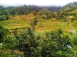
According to the Philippine Statistics Authority, the municipality has a land area of 242.69 square kilometres (93.70 sq mi) [15] constituting 8.76% of the 2,769.08-square-kilometre- (1,069.15 sq mi) total area of Benguet.
Kabayan is 82 kilometres (51 mi) from Baguio, 87 kilometres (54 mi) from La Trinidad, and 332 kilometres (206 mi) from Manila.
Kabayan is politically subdivided into 13 barangays. [16] Each barangay consists of puroks and some have sitios.
PSGC | Barangay | Population | ±% p.a. | |||
---|---|---|---|---|---|---|
2020 [3] | 2010 [17] | |||||
141107001 | Adaoay | 4.4% | 692 | 670 | 0.32% | |
141107002 | Anchukey | 1.8% | 290 | 296 | −0.20% | |
141107003 | Ballay | 19.0% | 3,011 | 2,623 | 1.39% | |
141107004 | Bashoy | 13.7% | 2,165 | 1,597 | 3.09% | |
141107005 | Batan | 6.8% | 1,072 | 944 | 1.28% | |
141107009 | Duacan | 4.8% | 758 | 709 | 0.67% | |
141107010 | Eddet | 5.9% | 927 | 740 | 2.28% | |
141107012 | Gusaran | 9.2% | 1,460 | 1,330 | 0.94% | |
141107013 | Kabayan Barrio | 2.7% | 423 | 337 | 2.30% | |
141107014 | Lusod | 5.5% | 872 | 794 | 0.94% | |
141107016 | Pacso | 7.6% | 1,208 | 1,247 | −0.32% | |
141107017 | Poblacion (Central) | 12.1% | 1,918 | 1,567 | 2.04% | |
141107018 | Tawangan | 6.4% | 1,010 | 734 | 3.24% | |
Total | 15,806 | 15,806 | 0.00% |
In the 2010 Census of Population and Housing, Barangay Anchukey would be the least populated barangay in the province of Benguet. [17]
Climate data for Kabayan, Benguet | |||||||||||||
---|---|---|---|---|---|---|---|---|---|---|---|---|---|
Month | Jan | Feb | Mar | Apr | May | Jun | Jul | Aug | Sep | Oct | Nov | Dec | Year |
Mean daily maximum °C (°F) | 21 (70) | 22 (72) | 23 (73) | 25 (77) | 24 (75) | 24 (75) | 23 (73) | 23 (73) | 23 (73) | 23 (73) | 22 (72) | 21 (70) | 23 (73) |
Mean daily minimum °C (°F) | 13 (55) | 14 (57) | 15 (59) | 17 (63) | 18 (64) | 18 (64) | 18 (64) | 18 (64) | 18 (64) | 17 (63) | 15 (59) | 14 (57) | 16 (61) |
Average precipitation mm (inches) | 38 (1.5) | 57 (2.2) | 77 (3.0) | 141 (5.6) | 390 (15.4) | 355 (14.0) | 426 (16.8) | 441 (17.4) | 426 (16.8) | 259 (10.2) | 97 (3.8) | 57 (2.2) | 2,764 (108.9) |
Average rainy days | 10.4 | 12.1 | 15.4 | 20.4 | 26.7 | 27.1 | 28.7 | 28.0 | 26.4 | 19.9 | 14.1 | 12.3 | 241.5 |
Source: Meteoblue (modeled/calculated data, not measured locally) [18] |
Year | Pop. | ±% p.a. |
---|---|---|
1903 | 22 | — |
1918 | 2,841 | +38.27% |
1939 | 4,190 | +1.87% |
1948 | 3,805 | −1.07% |
1960 | 5,869 | +3.68% |
1970 | 7,116 | +1.94% |
1975 | 8,363 | +3.29% |
1980 | 9,072 | +1.64% |
1990 | 10,306 | +1.28% |
1995 | 10,510 | +0.37% |
2000 | 12,344 | +3.51% |
2007 | 12,657 | +0.35% |
2010 | 13,588 | +2.62% |
2015 | 15,260 | +2.23% |
2020 | 15,806 | +0.69% |
Source: Philippine Statistics Authority [19] [17] [20] [21] |
In the 2020 census, Kabayan had a population of 15,806. [3] The population density was 65 inhabitants per square kilometre (170/sq mi).
Graphs are unavailable due to technical issues. There is more info on Phabricator and on MediaWiki.org. |
Kabayan, belonging to the lone congressional district of the province of Benguet, is governed by a mayor designated as its local chief executive and by a municipal council as its legislative body in accordance with the Local Government Code. The mayor, vice mayor, and the councilors are elected directly by the people through an election which is being held every three years.
Position | Name |
---|---|
Congressman | Eric G. Yap (elected) [30] |
Mayor | Florante B. Bantales Jr. |
Vice-Mayor | Mike E. Badival |
Councilors | Rex Alwin G. Aquisan |
Sario M. Minas | |
Roli Francis L. Wakit | |
Orlan W. Kelcho | |
Roli Nover L. Baskial | |
Ghislyn F. Lucio-Marave | |
Rudy B. Alos | |
Marylou B. Cosalan | |
Kabayan is best known for the antiquated centuries-old mummies and Mount Pulag, the third highest mountain in the Philippines. The Kabayan mummy burial caves are officially proclaimed Philippine National Cultural Treasures pursuant to Presidential Decree No. 374, and is under consideration as a World Heritage Site. [31] The mummified body of Apo Annu, a tribal leader, was stolen but recovered by an antique collector and was returned to the town. Archaeologists from various countries have visited the town to promote preservation of the mummies due to deterioration of the cadavers. The caves containing the cadavers of these mummies have been declared by Monument Watch as one of the "100 Most Endangered Sites" in the world. [32]
Mount Pulag is a destination for mountaineers, hikers, including picnickers. At its summit, the climbers can see the surroundings of the whole north Luzon.
As of 2014, Kabayan has 22 public elementary schools and 3 public secondary schools. [33] [34] [35]
|
|
Benguet, officially the Province of Benguet, is a landlocked province of the Philippines located in the southern tip of the Cordillera Administrative Region in the island of Luzon. Its capital is La Trinidad.
Mountain Province is a landlocked province of the Philippines in the Cordillera Administrative Region in Luzon. Its capital is Bontoc. Mountain Province was formerly referred to as Mountain in some foreign references. The name is usually shortened by locals to Mt. Province.
Apayao, officially the Province of Apayao, is a landlocked province in the Philippines in the Cordillera Administrative Region in Luzon. Kabugao serves as its capital. The provincial capitol and its associated offices are located at the New Government Center in Luna.
The Cordillera Administrative Region, also known as the Cordillera Region and Cordillera, is an administrative region in the Philippines, situated within the island of Luzon. It is the only landlocked region in the insular country, bordered by the Ilocos Region to the west and southwest, and by the Cagayan Valley Region to the north, east, and southeast. It is the least populous region in the Philippines, with a population less than that of the city of Manila.
Mount Pulag is Luzon's highest peak at 2,928 metres (9,606 ft) above sea level, third-highest mountain in the Philippines, and the 26th-highest peak of an island on Earth.
Bucloc, officially the Municipality of Bucloc, is a 6th class municipality in the province of Abra, Philippines. According to the 2020 census, it has a population of 2,395 people.
Villaviciosa, officially the Municipality of Villaviciosa, is a 5th class municipality in the province of Abra, Philippines. According to the 2020 census, it has a population of 5,675 people.
Kayapa, officially the Municipality of Kayapa, is a 3rd class municipality in the province of Nueva Vizcaya, Philippines. According to the 2020 census, it has a population of 26,469 people.
La Trinidad, officially the Municipality of La Trinidad, is a 1st class municipality and capital of the province of Benguet, Philippines. According to the 2020 census, it has a population of 137,404 people.
Atok, officially the Municipality of Atok,, is a 4th class municipality in the province of Benguet, Philippines. According to the 2020 census, it has a population of 19,218 people.
Bakun, officially the Municipality of Bakun,, is a 3rd class municipality in the province of Benguet, Philippines. According to the 2020 census, it has a population of 14,535 people.
Bokod, officially the Municipality of Bokod,, is a 4th class municipality in the province of Benguet, Philippines. According to the 2020 census, it has a population of 14,435 people.
Buguias, officially the Municipality of Buguias,, is a 3rd class municipality in the province of Benguet, Philippines. According to the 2020 census, it has a population of 44,877 people. The municipality is home to the mummy of Apo Anno, one of the most revered and important folk hero in Benguet prior to Spanish arrival.
Itogon, officially the Municipality of Itogon,, is a 1st class municipality in the province of Benguet, Philippines. According to the 2020 census, it has a population of 61,498 people.
Kapangan, officially the Municipality of Kapangan,, is a 4th class municipality in the province of Benguet, Philippines. According to the 2020 census, it has a population of 19,297 people.
Kibungan, officially the Municipality of Kibungan, is a 4th class municipality in the province of Benguet, Philippines. According to the 2020 census, it has a population of 17,051 people.
Mankayan, officially the Municipality of Mankayan, is a 1st class municipality in the province of Benguet, Philippines. According to the 2020 census, it has a population of 37,233 people.
Sablan, officially the Municipality of Sablan, is a 5th class municipality in the province of Benguet, Philippines. According to the 2020 census, it has a population of 11,588 people.
Tuba, officially the Municipality of Tuba,, is a 1st class municipality in the province of Benguet, Philippines. According to the 2020 census, it has a population of 48,312 people.
Tublay, officially the Municipality of Tublay, is a 5th class municipality in the province of Benguet, Philippines. According to the 2020 census, it has a population of 19,429 people.
{{cite encyclopedia}}
: CS1 maint: numeric names: authors list (link)