Mountain Province

Last updated
Mountain Province
Maligcong Rice Terraces.jpg
Bontoc, Mountain Province (3299081695).jpg
Chico River in Bontoc.jpg
Sagada rice terraces.jpg
Sagada skyline (Sagada, Mountain Province; 12-01-2022).jpg
Bontoc0610-b.jpg
(from top: left to right) Maligcong Rice Terraces in Bontoc, Bontoc, Chico River, Sagada rice terraces, Sagada and Chico River in Bontoc.
Flag of Mountain Province.png
Seal of Mountain Province.png
Mountain in Philippines.svg
Location in the Philippines
OpenStreetMap
Mountain Province
Coordinates: 17°05′N121°10′E / 17.08°N 121.17°E / 17.08; 121.17
Country Philippines
Region Cordillera Administrative Region
Founded 1908
Capital Bontoc
Largest Municipality Bauko
Government
  Type Sangguniang Panlalawigan
   Governor Bonifacio C. Lacwasan Jr. (PDP-Laban)
   Vice Governor Francis O. Taulif (PDP-Laban)
   Representative Maximo Y. Dalug Jr. (NP)
  Legislature Mountain Province Provincial Board
Area
[1]
  Total2,157.38 km2 (832.97 sq mi)
  Rank58th out of 81
Highest elevation2,702 m (8,865 ft)
Population
 (2020 census) [2]
  Total158,200
  Rank76th out of 81
  Density73/km2 (190/sq mi)
   Rank75th out of 81
Divisions
   Independent cities 0
   Component cities 0
   Municipalities
10
   Barangays 144
   Districts Legislative district of Mountain Province
Time zone UTC+8 (PHT)
ZIP code
2616–2625
IDD : area code +63(0)74
ISO 3166 code PH-MOU
Spoken languages
Website mountainprovince.gov.ph

Mountain Province (Filipino : Lalawigang Bulubundukin) is a landlocked province of the Philippines in the Cordillera Administrative Region in Luzon. Its capital is Bontoc. Mountain Province was formerly referred to as Mountain in some foreign references. The name is usually shortened by locals to Mt. Province.

Contents

The province was named so for being in the Cordillera Central mountain range found in the upper realms of Luzon island.

Mountain Province was also the name of the historical province that included most of the current Cordillera provinces. This old province was established by the Philippine Commission in 1908, [3] [4] [5] and was later split in 1966 into Mountain Province, Benguet, Kalinga-Apayao and Ifugao. [6] [7] [8]

The province is also known for its mummy caves, which contain naturally mummified bodies, and for its hanging coffins. [6]

History

Spanish colonial era

The area of the Cordillera mountains proved difficult to control by the Spaniards. During the long Spanish rule, not much was done to bring the province under control. From 1566 to 1665, they sent expeditions to conquer the land but the rugged terrain and hostile indigenous population at the time were major obstacles to complete subjugation. [9] The first serious effort to subjugate them was made in 1785 when soldiers were sent from Cagayan to put down a revolt of the Kalingas. A famous Spanish explorer, Guillermo Galvez, conducted more than 40 forays to the mountainous region. [10]

Formerly called La Montañosa by the Spanish colonizers due to its mountainous terrain, [6] [11] the area was subdivided into 6 comandancias politico-militar. [12]

The 6 former Comandancias Politico-Militar of La Montañosa [12]
ComandanciaYear establishedComandanciaYear established
Benguet 1846 Amburayan 1889
Lepanto1852Kayapa1891
Bontoc1859Cabugaoan1891

American colonial era

Mountain Province
Former province of the Philippines
1908-1966
Mountain province 1918 map.jpg
The province in 1918
Capital Baguio
History 
 Established
June 18, 1908
 Disestablished
April 7, 1967
Preceded by
Succeeded by
Flag of the United States (1896-1908).svg Lepanto-Bontoc
Flag of the United States (1896-1908).svg Benguet
Flag of the United States (1896-1908).svg Cagayan
Flag of the United States (1896-1908).svg Nueva Vizcaya
Benguet Flag of the Philippines (1936-1985, 1985-1998).svg
Mountain Province Flag of the Philippines (1936-1985, 1985-1998).svg
Ifugao Flag of the Philippines (1936-1985, 1985-1998).svg
Kalinga-Apayao Flag of the Philippines (1936-1985, 1985-1998).svg
Today part ofCordillera Administrative Region

On August 19, 1908, during the American rule, the Philippine Commission enacted Act No. 1876, which organized the entire area of the Cordilleras into one large province, named Mountain Province. [3] [5] [6] [13]

The first governor was Samuel Kane, and the town of Bontoc was made the capital. It was originally composed of the sub-provinces of Amburayan, Apayao, Benguet, Lepanto-Bontoc, Ifugao and Kalinga. [5] [11]

Bontoc sub-province in 1918 Bontoc Subprovince 1918 map.JPG
Bontoc sub-province in 1918

Amburayan was later abolished in 1920 and its corresponding territories were transferred to the provinces of Ilocos Sur and La Union. Lepanto was also reduced in size and its towns were integrated into the sub-provinces of Bontoc and Benguet, and to the province of Ilocos Sur. [9] [14] [15]

Historical sub-provinces of Mountain Province under Act No. 1876 [3] [5] [12] [15]
Sub-provinceAbolished?Notes
Amburayan Yes, in 1920Territories annexed to Ilocos Sur and La Union [5] [15]
Apayao No
Benguet NoEastern towns annexed to Ilocos Sur and La Union in 1920 [15]
Ifugao No
Kalinga No
Lepanto-Bontoc Yes, in 1920Territories annexed to Ilocos Sur, Bontoc and Benguet [5] [15]

Philippine independence

Effective on April 7, 1967, Republic Act No. 4695 abolished the old Mountain Province, converting its sub-provinces into 4 independent provinces: Benguet, Ifugao, Kalinga-Apayao and Mountain Province (corresponding to the former Bontoc sub-province). [6] [8] [11]

Mountain Province would have been significantly affected by the Chico River Dam Project during the Marcos administration, as the Marcos regime's project would have flooded the municipalities of Sabangan, Sagada, Sadanga, Bontoc, Bauko, and parts of Barlig. [16] However, the indigenous peoples of Kalinga Province and Mountain Province resisted the project and when hostilities resulted in the murder of Macli-ing Dulag, the project became unpopular and was abandoned before Marcos was ousted by the 1986 People Power Revolution. [17]

On June 15, 1987, the Cordillera Administrative Region was established upon the issuance of Executive Order 220 by then-President Corazon Aquino, and Mountain Province was made one of its provinces. [9] [18] [19]

Geography

Mountain Province covers a total area of 2,157.38 square kilometres (832.97 sq mi) [20] occupying the central section of the Cordillera Administrative Region in Luzon. The province is bordered on the north by Kalinga, east by Isabela, south by Ifugao, southwest by Benguet, west by Ilocos Sur, and northwest by Abra.

Situated within the Cordillera Central, Mountain Province is 83% mountainous while 17% make up hills and levels. The province has many rivers, waterfalls, mountains, and caves. The central and western areas of the province are characterized by rugged mountains and steep cliffs, while the eastern portion has generally sloping terrain. [6] [11]

Administrative divisions

Mountain Province comprises ten municipalities, all encompassed by a lone legislative district. [20]

Political divisions Ph fil mountain province.png
Political divisions

Barangays

Mountain Province has 144 barangays comprising its 10 municipalities. [22]

As of 2010, the most populous barangay in the province is Poblacion in the municipality of Paracelis, with a total of 5,687 inhabitants. Balintaugan in the municipality of Bauko has the least population with only 144. [22]

Demographics

The population of Mountain Province in the 2020 census was 158,200 people, [2] with a density of 73 inhabitants per square kilometre or 190 inhabitants per square mile.

Population census of Mountain Province
YearPop.±% p.a.
1903 23,441    
1918 49,055+5.05%
1939 59,138+0.89%
1948 62,003+0.53%
1960 85,866+2.75%
1970 93,112+0.81%
1975 94,096+0.21%
1980 103,052+1.83%
YearPop.±% p.a.
1990 116,535+1.24%
1995 130,755+2.18%
2000 140,439+1.54%
2007 148,661+0.79%
2010 154,187+1.34%
2015 154,590+0.05%
2020 158,200+0.45%
Source: Philippine Statistics Authority [21] [22] [23]
Population by ethnicity (2000) [24]
EthnicityNumber
Kankanaey
72,694 (51.80%)
Balangao / Baliwon
18,886 (13.46%)
Bontoc
17,234 (12.28%)
Ilocano
6,968 (4.97%)
Applai
2,947 (2.10%)
Binontok
2,510 (1.79%)
Kalinga
2,468 (1.76%)

Other local ethnicity
16,197 (11.54%)
Other foreign ethnicity
22 (0.02%)
Not Reported
413 (0.29%)

Based on the 2000 census survey, Kankana-ey comprised

Religion

An Anglican church in Sagada Anglican Church,Pobalcion, Sagada, Mountain Province.JPG
An Anglican church in Sagada

Anglicanism predominates in the province with approximately 60% adherence with the other religions such as Roman Catholicism, Seventh-Day Adventist Church, Iglesia Filipina Indepiendente, Iglesia ni Cristo and Free Believers in Christ Fellowship Members Church of God International (MCGI)[ citation needed ]

Mountain Province is the only predominantly Protestant province in the Philippines.

Economy

Tourism

The province has several rice terraces in seven of its different towns: [11]

The mountainous province also offers excellent mountain climbing experiences with two of its mountains among the top 10 highest points in the Philippines:

Barlig, Mountain Province, Philippines.jpg
Rice terraces in Barlig

Government

List of recent governors

Related Research Articles

<span class="mw-page-title-main">Benguet</span> Province in Cordillera, Philippines

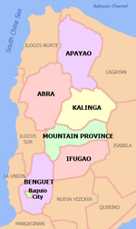
Benguet, officially the Province of Benguet, is a landlocked province of the Philippines located in the southern tip of the Cordillera Administrative Region in the island of Luzon. Its capital is La Trinidad.

<span class="mw-page-title-main">Ifugao</span> Province in Cordillera, Philippines

Ifugao, officially the Province of Ifugao, is a landlocked province of the Philippines in the Cordillera Administrative Region in Luzon. Its capital is Lagawe and it borders Benguet to the west, Mountain Province to the north, Isabela to the east, and Nueva Vizcaya to the south.

<span class="mw-page-title-main">Apayao</span> Province in Cordillera, Philippines

Apayao, officially the Province of Apayao, is a landlocked province in the Philippines in the Cordillera Administrative Region in Luzon. Kabugao serves as its capital. The provincial capitol and its associated offices are located at the New Government Center in Luna.

<span class="mw-page-title-main">Kalinga (province)</span> Province in Cordillera, Philippines

Kalinga, officially the Province of Kalinga, is a landlocked province in the Philippines situated within the Cordillera Administrative Region in Luzon. Its capital is Tabuk and borders Mountain Province to the south, Abra to the west, Isabela to the east, Cagayan to the northeast, and Apayao to the north. Kalinga and Apayao are the result of the 1995 partitioning of the former province of Kalinga-Apayao which was seen to better service the respective needs of the various indigenous peoples in the area.

<span class="mw-page-title-main">Cordillera Administrative Region</span> Administrative region of the Philippines

The Cordillera Administrative Region, also known as the Cordillera Region and Cordillera, is an administrative region in the Philippines, situated within the island of Luzon. It is the only landlocked region in the insular country, bordered by the Ilocos Region to the west and southwest, and by the Cagayan Valley Region to the north, east, and southeast. It is the least populous region in the Philippines, with a population less than that of the city of Manila.

<span class="mw-page-title-main">Cordillera Central (Luzon)</span> Mountain range in Luzon, Philippines

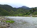
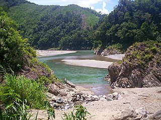
The Cordillera Central or Cordillera Range is a massive mountain range 320 kilometres (200 mi) long north-south and 118 kilometres (73 mi) east-west situated in the north-central part of the island of Luzon, in the Philippines. The mountain range encompasses all provinces of the Cordillera Administrative Region, as well as portions of eastern Ilocos Norte, eastern Ilocos Sur, eastern La Union, northeastern Pangasinan, western Nueva Vizcaya, and western Cagayan.

<span class="mw-page-title-main">Igorot people</span> Ethnic group in the Philippines

The indigenous peoples of the Cordillera in northern Luzon, Philippines, often referred to by the exonym Igorot people, or more recently, as the Cordilleran peoples, are an ethnic group composed of nine main ethnolinguistic groups whose domains are in the Cordillera Mountain Range, altogether numbering about 1.8 million people in the early 21st century.

<span class="mw-page-title-main">Bauko</span> Municipality in Mountain Province, Philippines

Bauko, officially the Municipality of Bauko is a 4th class municipality in the province of Mountain Province, Philippines. According to the 2020 census, it has a population of 32,021 people.

<span class="mw-page-title-main">Barlig</span> Municipality in Mountain Province, Philippines

Barlig, officially the Municipality of Barlig is a 5th class municipality in the province of Mountain Province, Philippines. According to the 2020 census, it has a population of 4,796 people.

<span class="mw-page-title-main">Bontoc, Mountain Province</span> Capital of the Mountain Province, Philippines

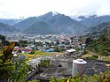
Bontoc, officially the Municipality of Bontoc, is a 2nd class municipality and capital of the province of Mountain Province, Philippines. According to the 2020 census, it has a population of 24,104 people.

<span class="mw-page-title-main">Natonin</span> Municipality in Mountain Province, Philippines

Natonin, officially the Municipality of Natonin, is a 4th class municipality in the province of Mountain Province, Philippines. According to the 2020 census, it has a population of 10,339 people.

<span class="mw-page-title-main">Sabangan</span> Municipality in Mountain Province, Philippines

Sabangan, officially the Municipality of Sabangan is a 5th class municipality in the province of Mountain Province, Philippines. According to the 2020 census, it has a population of 9,621 people.

<span class="mw-page-title-main">Sadanga</span> Municipality in Mountain Province, Philippines

Sadanga, officially the Municipality of Sadanga is a 5th class municipality in the province of Mountain Province, Philippines. According to the 2020 census, it has a population of 8,427 people.

<span class="mw-page-title-main">Sagada</span> Municipality in Mountain Province, Philippines

Sagada, officially the Municipality of Sagada is a 5th class municipality in the province of Mountain Province, Philippines. According to the 2020 census, it has a population of 11,510 people.

<span class="mw-page-title-main">Bokod, Benguet</span> Municipality in Benguet, Philippines

Bokod, officially the Municipality of Bokod,, is a 4th class municipality in the province of Benguet, Philippines. According to the 2020 census, it has a population of 14,435 people.

<span class="mw-page-title-main">Buguias</span> Municipality in Benguet, Philippines

Buguias, officially the Municipality of Buguias,, is a 3rd class municipality in the province of Benguet, Philippines. According to the 2020 census, it has a population of 44,877 people. The municipality is home to the mummy of Apo Anno, one of the most revered and important folk hero in Benguet prior to Spanish arrival.

<span class="mw-page-title-main">Abra (province)</span> Province in Cordillera, Philippines

Abra, officially the Province of Abra, is a province in the Cordillera Administrative Region of the Philippines. Its capital is the municipality of Bangued. It is bordered by Ilocos Norte on the northwest, Apayao on the northeast, Kalinga on the mid-east, Mountain Province on the southeast, and Ilocos Sur on the southwest.

<span class="mw-page-title-main">Rice Terraces of the Philippine Cordilleras</span> World Heritage Site in Luzon, the Philippines

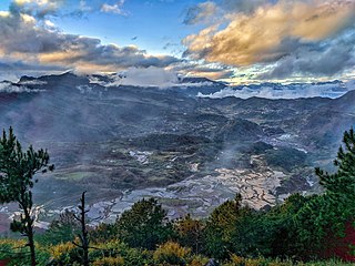
The Rice Terraces of the Philippine Cordilleras are a World Heritage Site consisting of a complex of rice terraces on the island of Luzon in the Philippines. They were inscribed on the UNESCO World Heritage List in 1995, the first-ever property to be included in the cultural landscape category of the World Heritage List. This inscription has five sites: the Batad Rice Terraces and Bangaan Rice Terraces, Mayoyao Rice Terraces, Hungduan Rice Terraces and Nagacadan Rice Terraces, all in Ifugao Province. The Ifugao Rice Terraces reach a higher altitude and were built on steeper slopes than many other terraces. The Ifugao complex of stone or mud walls and the careful carving of the natural contours of hills and mountains combine to make terraced pond fields, coupled with the development of intricate irrigation systems, harvesting water from the forests of the mountain tops, and an elaborate farming system.

The legislative districts of Mountain Province are the representations of Mountain Province in the various national legislatures of the Philippines. The province is currently represented in the lower house of the Congress of the Philippines through its lone congressional district.

The COVID-19 pandemic in the Cordillera Administrative Region is part of the worldwide pandemic of coronavirus disease 2019 caused by severe acute respiratory syndrome coronavirus 2. The virus reached the Cordillera Administrative Region on March 20, 2020, when the first case of the disease was confirmed to involve a resident of Manabo, Abra. All provinces, as well as the independent city of Baguio has recorded at least one confirmed COVID-19 case.

References

  1. "List of Provinces". PSGC Interactive. Makati, Philippines: National Statistical Coordination Board. Retrieved 23 December 2013.
  2. 1 2 3 Census of Population (2020). Table B - Population and Annual Growth Rates by Province, City, and Municipality - By Region. Philippine Statistics Authority . Retrieved 8 July 2021.
  3. 1 2 3 Worcester, Dean C.; Philippine Commission (1908). Seventh Annual Report of the Secretary of the Interior to the Philippine Commission for the Fiscal Year Ended June 30, 1908 (Digitized by Google on 23 Nov 2005 (Original file from the University of Michigan)). Manila: U.S. Government Printing Office. pp. 17–19. Retrieved 2 January 2015.
  4. Keesing, Felix Maxwell; Keesing, Marie Margaret; Keesing, Marie Martin; Institute of Pacific Relations (contributor); International Research Committee (contributor) (1934). Taming Philippine Headhunters: A Study of Government and of Cultural Change in Northern Luzon. Stanford University Press. p. 69. ISBN   9780804721103 . Retrieved 2 January 2015.
  5. 1 2 3 4 5 6 Ingles, Raul Rafael (2008). 1908 :The Way it Really was : Historical Journal for the UP Centennial, 1908-2008. Diliman, Quezon City: University of the Philippines Press. p. 339. ISBN   9789715425803 . Retrieved 22 October 2014.
  6. 1 2 3 4 5 6 Lancion, Conrado M. Jr.; de Guzman, Rey (cartography) (1995). "The Provinces". Fast Facts about Philippine Provinces (The 2000 Millenium ed.). Makati, Metro Manila: Tahanan Books. pp. 108–109. ISBN   971-630-037-9 . Retrieved 16 January 2015.
  7. "Natural Attractions found in Atok". Province of Benguet. Retrieved 13 August 2013.
  8. 1 2 "Republic Act No. 4695: An Act Creating the Provinces of Benguet, Mountain Province, Ifugao and Kalinga-Apayao". Chan Robles Virtual Law Library. Retrieved 22 October 2014.
  9. 1 2 3 "Mt. Province". VisitMyPhilippines.com The Ultimate Travel Guide for Tourists. Department of Tourism. Retrieved 23 December 2013.
  10. "Area of Coverage: The Region". ati.da.gov.ph. 10 August 2017. Retrieved 19 January 2021.
  11. 1 2 3 4 5 "Facts & Figures: Mountain Province". Philippine Statistics Authority - National Statistical Coordination Board - Cordillera Administrative Region . Archived from the original on 1 September 2016. Retrieved 22 October 2014.
  12. 1 2 3 "Benguet History". Province of Benguet (official website). Archived from the original on 19 October 2014. Retrieved 22 October 2014. Benguet was once part of Mountain Province.
  13. "Act No. 1876". PhilippineLaw.info. 18 August 1908. Archived from the original on 15 October 2014. Retrieved 22 October 2014.
  14. Philippines. Census Office; Buencamino, Felipe; Villamor, Ignacio (1920). Census of the Philippine Islands Taken Under the Direction of the Philippine Legislature in the Year 1918, Volume 1. Bureau of printing. p. 68.
  15. 1 2 3 4 5 "Cordillera Administrative Region History". Cordillera Connection (Blogspot). 14 August 2009. Retrieved 22 October 2014.
  16. "Valley of Sorrow". Asiaweek. 1980-09-05.
  17. Doyo, Ma. Ceres P. (2015). Macli-ing Dulag: Kalinga Chief, Defender of the Cordillera. Diliman, Quezon City: University of the Philippines Press. ISBN   978971542772-2.
  18. "Regional Profile: Cordillera Administrative Region (CAR)". CountrySTAT Philippines. Archived from the original on 22 October 2014. Retrieved 22 October 2014.
  19. "The Cordillera Administrative Region (CAR)". Department of Agriculture. Retrieved 22 October 2014.
  20. 1 2 3 "Province: Mountain Province". PSGC Interactive. Quezon City, Philippines: Philippine Statistics Authority . Retrieved 8 January 2016.
  21. 1 2 Census of Population (2015). Highlights of the Philippine Population 2015 Census of Population. Philippine Statistics Authority . Retrieved 20 June 2016.
  22. 1 2 3 Census of Population and Housing (2010). Population and Annual Growth Rates for The Philippines and Its Regions, Provinces, and Highly Urbanized Cities (PDF). National Statistics Office . Retrieved 29 June 2016.
  23. Census of Population and Housing (2010). "Cordillera Administrative Region (CAR)" (PDF). Total Population by Province, City, Municipality and Barangay. National Statistics Office . Retrieved 29 June 2016.
  24. 1 2 "Mountain Province – Home of the Kankanais; Table 4. Household Population by Ethnicity and Sex: Mountain Province, 2000". Philippine Statistics Authority. 6 February 2002. Archived from the original on 15 June 2002. Retrieved 27 July 2016.
  25. "Poverty incidence (PI):". Philippine Statistics Authority. Retrieved December 28, 2020.
  26. "Estimation of Local Poverty in the Philippines" (PDF). Philippine Statistics Authority. 29 November 2005.
  27. "2009 Official Poverty Statistics of the Philippines" (PDF). Philippine Statistics Authority. 8 February 2011.
  28. "Annual Per Capita Poverty Threshold, Poverty Incidence and Magnitude of Poor Population, by Region and Province: 1991, 2006, 2009, 2012 and 2015". Philippine Statistics Authority. 27 August 2016.
  29. "Annual Per Capita Poverty Threshold, Poverty Incidence and Magnitude of Poor Population, by Region and Province: 1991, 2006, 2009, 2012 and 2015". Philippine Statistics Authority. 27 August 2016.
  30. "Annual Per Capita Poverty Threshold, Poverty Incidence and Magnitude of Poor Population, by Region and Province: 1991, 2006, 2009, 2012 and 2015". Philippine Statistics Authority. 27 August 2016.
  31. "Updated Annual Per Capita Poverty Threshold, Poverty Incidence and Magnitude of Poor Population with Measures of Precision, by Region and Province: 2015 and 2018". Philippine Statistics Authority. 4 June 2020.