* Tacloban is a highly-urbanized city, politically independent from Leyte. ** Ormoc is an independent-component city.
Leyte (also Northern Leyte; Waray: Norte san/Amihanan nga Leyte/Probinsya han Leyte; Cebuano: Amihanang Leyte; Tagalog: Hilagang Leyte), officially the Province of Leyte, is a province in the Philippines located in the Eastern Visayasregion occupying the northern three-quarters of Leyte Island (with the remaining portion being the province of Southern Leyte). Its capital (and largest city) is the city of Tacloban, administered independently from the province, as well as the regional center of Eastern Visayas. Leyte is thus north of Southern Leyte, south of Biliran, and west of Samar Island. To the west across the Camotes Sea is the province of Cebu.
The historical name of the Philippines, "Las Islas Felipenas", named by Spanish explorer Ruy López de Villalobos in honor of Prince Philip of Spain, used to refer to the islands of Leyte and Samar only, until it was adopted to refer to the entire archipelago.[4]
The island of Leyte is known as Tandaya during the 16th century.[5]
Leyte is especially prone to typhoons because it geographically faces toward the Pacific Ocean. On 8 November 2013, the province was severely affected by Super Typhoon Yolanda (Haiyan). The typhoon, known internationally as Haiyan, and domestically referred to as Yolanda, killed thousands of people and garnered significant international media attention. Leyte suffered similar destruction and loss of life in 1991 from Tropical Storm Uring (Thelma).
History
Leyte province in 1918, before its division into three provinces, namely Leyte, Southern Leyte and Biliran
Early history
The island of Leyte was once the location of Mairete, meaning land of Ete, a historic community which was ruled by Datu Ete centered in the present-day municipality of Leyte and nearby towns. It was the oldest city-state in the entire Eastern Visayas region. Before being colonized by Spain, the island was once home to indigenous animistWarays to the East and other indigenous Hindu-BuddhistVisayan groups to the west.
Spanish colonial era
The Spanish explorer Ruy López de Villalobos, first came to the island in 1543 and named it Las Islas Felipinas. When the Spanish government established a government in Cebu, Leyte and Samar became part of the province of Cebu. In 1595, the religious Jesuits established a mission in Carigara which preceded the mission established in Palo in 1596 and Ormoc and Alangalang missions in 1597. In 1735, Leyte and Samar were separated from Cebu to be established as a single provincial government with Carigara as the first provincial capital. Leyte had jurisdiction over Samar. In 1768, Leyte and Samar were split into two separate provinces.
On March 27, 1923, Act No 3117 was proposed to divide Leyte into Occidental Leyte and Oriental Leyte but was not proclaimed by the Governor-General of the Philippines.
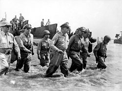
When Americans stormed ashore at Leyte, it fulfilled the promise to return made by Gen. Douglas MacArthur in the days following the fall of the Philippines to the Japanese in 1942.
The First Battle of Leyte occurred on October 20, 1944. A successful Allied invasion of the island was the crucial element to the eventual Filipino and American victory in the Philippines.
Contemporary
On April 8, 1959, Biliran became a sub-province of Leyte by virtue of Republic Act No. 2141.[6] On May 22, 1959, Republic Act No. 2227 was passed into law that separated the third Congressional District of Leyte, then comprising the southern portion of the namesake island, into a separate province of Southern Leyte.[7]
The beginning months of the 1970s had marked a period of turmoil and change in the Philippines,[8][9] as well as in Leyte.[10][11][12] During his bid to be the first Philippine president to be re-elected for a second term, Ferdinand Marcos launched an unprecedented number of foreign debt-funded public works projects. This caused[13][14] the Philippine economy to take a sudden downwards turn known as the 1969 Philippine balance of payments crisis, which led to a period of economic difficulty and a significant rise of social unrest.[15][16][17][18]:"43" With only a year left in his last constitutionally allowed term as president, Ferdinand Marcos placed the Philippines under Martial Law in September 1972 and thus retained the position for fourteen more years.[19] This period in Philippine history is remembered for the Marcos administration's record of human rights abuses,[20][21] particularly targeting political opponents, student activists, journalists, religious workers, farmers, and others who fought against the Marcos dictatorship.[22]
In Leyte particularly, Human Rights documentors were able to identify numerous cases of murders, abductions, tortures, maulings, as well as hamleting of communities in the towns of Abuyog, Javier, Mac Arthur Burauen, Hindang, Hilongos, Baybay, Inopacan and Mahaplag and in the Southern Leyte Barangays of San Juan, Anahawan, Hinunangan and Sodong - all in the year 1985 alone.[10] The hamlet created by the military in Barangay Pikasor in the Municipality of Abuyog was particularly notable because paramilitary forces massacred the residents who had been gathered there that year.[23]
This era also saw the construction of the San Juanico Bridge between Samar and Leyte, which began as one of the high-visibility foreign-loan funded projects of Ferdinand Marcos’ 1969 reelection campaign, and finished four years later in time to be inaugurated on then-First LadyImelda Marcos' birthday on July 2, 1973.[24] The project was initially criticised as a white elephant by officials at the National Economic and Development Authority, noting that it was "useless and expensive to maintain",[25] because its average daily traffic was too low to justify the cost of its construction.[25] As a result, its construction has been associated with what has been called the Marcoses' "edifice complex"[26][27] although economic activity in Samar and Leyte has since finally caught up with the bridge's intended function.[27] At the time, its name was used as a slang term for onte of the torture methods used by the Marcos dictatorship, in which a person being beaten while the victim's head and feet lay on separate beds and the body is suspended as though to form a bridge.[28][29][30]
Contemporary
Creation of Biliran
On May 11, 1992, Biliran was separated from Leyte to become an independent province, by virtue of Republic Act No. 7160.[31]
Ormoc is an independent component city, while the capital Tacloban was declared a highly urbanized city in 2008. Both cities govern themselves independently of the province and their residents do not vote for elective provincial officials.
Baybay attained cityhood in 2007 but reverted to its municipal status when the Supreme Court declared its city charterunconstitutional in 2008. It regained its city status following the reversal of the Supreme Court decision dated December 22, 2009.[35] In August 2010, however, a resolution had been passed reverting 16 cities, one of which was Baybay, to municipal status. It was on February 15, 2011, that the Supreme Court reversed its decision once again, allowing Baybay, along with the other 16 cities, to retain their cityhood status.
The population of Leyte in the 2024 census was 1,823,458 people,[3] with a density of 290 inhabitants per square kilometre or 750 inhabitants per square mile. When Tacloban is included for geographical purposes, the population comes to 1,966,768 people, with a density of 302/km2 (782/sqmi).
The people of Leyte province are subdivided into two closely related Visayan ethnolinguistic groups. In the northern, central and eastern parts are the Warays and in the western part are the Cebuanos.
Tacloban-Waray dialect is considered as the standard form of Waray language and is used as the de facto lingua franca in both Leyte and Samar Islands. Aside from Cebuano and Waray, most Leyteños can also speak and understand Filipino and English. Some students who have studied the Spanish language and a few descendants of Spanish colonists can also speak and understand Spanish.
Leyte is predominantly a Roman Catholic Christian province. The 2000 census stated that 97% of Leyte's population adhered to Roman Catholicism, one of the highest percentages in the Visayas.[citation needed] The remaining 3% were adherents of other different Christian denominations and sects, such as the indigenous Iglesia ni Cristo, the Kingdom of Jesus Christ and Members Church of God International, popularly known as Ang Dating Daan, and many other foreign religious groups like the Mormons, Born Again Christians, Baptists, Pentecostals, Seventh-Day Adventists (Sabadistas), and many more.
Islam is also present in the province and concentrated in the metropolitan Tacloban area. It comprises 0.3% of Tacloban City's population, and its adherents are mainly the Maranao people and other Moro migrants from Mindanao who work mostly as traders.
Official provincial seal
The upper portion is a perspective of the national Freedom Park commemorating the landing of GeneralDouglas MacArthur and the American Liberation Forces in Leyte during World War II. The white cross represents the 2nd phase of Leyte's development when Magellan stopped here on his way to Cebu. The alphabet on the cross argent is the ancient Visayan paleographic syllabary of the letter L which stands for Leyte. The stars around the inner circle symbolize the forty-one towns of Leyte and the everlasting flame symbolizes the soldiers who died during World War II.
The economy of Leyte is a mixed agriculture, fishing, industrial, energy and mining. Rice is farmed in the lowland plains areas specifically those around Tacloban, while coconut farming, is the main cash crop in upland and mountainous areas. Sugarcane plantation is no. 1 produce in Ormoc City. Since Leyte is an island province, fishing is a major source of livelihood among coastal residents.
The province is the site of the largest geothermal power plant in Asia, making it one of the resource-rich provinces of the Philippines. Excess energy of the numerous power plants in the geothermal valley that generate electricity is supplied to the national grid that adds to the energy demand in Luzon and Mindanao. Mining industry has started to pick up in the province with the exploration in MacArthur. The iron smelting in Isabel has been operational for more than 20 years since its inception.
Leyte ICT Park
The Leyte Information Communications Technology (ICT) Park is one of the economic zones approved by the Philippine Economic Zone Authority (PEZA).[46] Located in Pawing, Palo, Leyte, the 6.8 facility hosts two business process outsourcing (BPO) companies, namely, the Expert Global Solutions (EGS) Company (formerly APAC Customer Services, Inc.) and ACUDATA, Inc. (a financial and data services BPO). However, EGS decided to fully close its operations after its facility was destroyed by Typhoon Haiyan in 2013.
Leyte is connected by air with its only commercial airport located in Tacloban City. Daniel Z. Romualdez Airport, which is one of the busiest airports in the Philippines, is served by three major airlines, Philippine Airlines, Cebu Pacific and AirAsia. Tacloban Airport primarily serves connecting flights from major Philippine cities (Manila and Cebu).
↑Lancion, Conrado M. Jr. (1995). "The Provinces; Leyte". Fast Facts about Philippine Provinces. cartography by de Guzman, Rey (The 2000 Milleniumed.). Makati, Metro Manila, Philippines: Tahanan Books. p.96. ISBN971-630-037-9. Retrieved 26 December 2015.
↑Magno, Alexander R., ed. (1998). "Democracy at the Crossroads". Kasaysayan, The Story of the Filipino People Volume 9:A Nation Reborn. Hong Kong: Asia Publishing Company Limited.
↑Abinales, P.N.; Amoroso, Donna J. (2005). State and society in the Philippines. Lanham, MD: Rowman & Littlefield Publishers. ISBN978-0742510234. OCLC57452454.
↑Melencio, Gloria Esguerra (January–December 2019). "Stories of the Nameless: Eyewitness Accounts of Martial Law Victims and Survivors". UP Los Baños Journal. XVII (78).
↑Robles, Raissa (2016). Marcos Martial Law: Never Again: A brief history of torture and atrocity under the New Society. Quezon City: Filipinos for A Better Philippines, Inc. ISBN978-621-95443-1-3. OCLC952277519.
This page is based on this Wikipedia article Text is available under the CC BY-SA 4.0 license; additional terms may apply. Images, videos and audio are available under their respective licenses.