Limasawa

Last updated
Limasawa
Mazaua
Municipality of Limasawa
Flag of Limasawa, Southern Leyte.png
Seal of Limasawa.jpg
Nickname: 
"The First Mass Site in the Philippines"
Motto: 
Ang hindi marunong magmahal sa sariling wika ay higit pa sa hayop at malansang isda.
Ph locator southern leyte limasawa.png
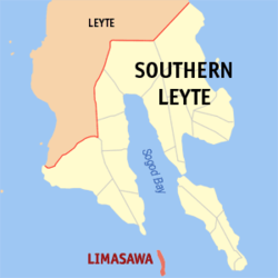
Map of Southern Leyte with Limasawa highlighted
OpenStreetMap
Limasawa
Philippines location map (square).svg
Red pog.svg
Limasawa
Location within the Philippines
Coordinates: 9°54′28″N125°04′30″E / 9.9078°N 125.075°E / 9.9078; 125.075
Country Philippines
Region Eastern Visayas
Province Southern Leyte
District 1st district
Founded June 11, 1978
(Completely became official on August 27, 1989)
Barangays 6 (see Barangays)
Government
  Type Sangguniang Bayan
   Mayor Melchor P. Petracorta (Lakas)
   Vice Mayor Ritche L. Salomon (Lakas)
   Representative Luz V. Mercado
   Municipal Council
Members
   Electorate 4,407 voters (2022)
Area
[2]
  Total6.98 km2 (2.69 sq mi)
Elevation
13 m (43 ft)
Highest elevation
848 m (2,782 ft)
Lowest elevation
0 m (0 ft)
Population
 (2020 census) [3]
  Total7,118
  Density1,000/km2 (2,600/sq mi)
   Households
1,491
Demonym Limasawan
Economy
   Income class 6th municipal income class
   Poverty incidence
22.48
% (2018) [4]
   Revenue 57.98 million (2020)
   Assets 214.1 million (2020)
   Expenditure 59.73 million (2020)
   Liabilities 58.3 million (2020)
Service provider
  ElectricitySouthern Leyte Electric Cooperative (SOLECO)
Time zone UTC+8 (PST)
ZIP code
6605
PSGC
IDD : area code +63(0)53
Native languages Boholano dialect
Cebuano
Tagalog

Limasawa, officially the Municipality of Limasawa (Cebuano: Lungsod sa Limasawa; Filipino: Bayan ng Limasawa), is an island municipality in the province of Southern Leyte, Philippines. According to the 2020 census, it has a population of 6,191 people. [3]

Contents

History

Limasawa was the second island (after Suluan) of the Philippines that the Magellan Expedition landed on. Antonio Pigafetta documented the island as "Mazaua". He described it as being inhabited with cultivated fields. In March 28, 1521 the Magellan Expedition met with two rulers, Rajah Colambu and Rahah Siaui, of the Rajahnate of Butuan and "Calagan" (Caraga), which Pigafetta misidentified as islands. The rulers were on a hunting expedition on Limasawa (which were under their domain) with two balangay ships. The rulers entertained Magellan's crew with feasting for a few days. Afterwards, Father Pedro de Valderrama performed the first mass in the Philippines on Easter Sunday (March 31, 1521). Magellan also climbed the highest elevation in Limasawa and erected a cross before leaving for "Zubu" (Cebu). [5] :136–145

At the request of the residents of the island of Limasawa, the six barangays that comprise that island were detached and separated from the municipality of Padre Burgos through Presidential Decree No. 1549, signed by then President Ferdinand Marcos on June 11, 1978, and constituted as the Municipality of Limasawa. [6] Limasawa completely became a municipality on August 27, 1989, after then President Corazon Aquino ordered the plebiscite which its residents voted in favor of the creation. The island, also known as Sarangani Island, is located south of Leyte, in the Mindanao or Bohol Sea. It is about 10 kilometres (6.2 mi) long from north to south and is the smallest municipality in the province, in both area and population.

Geography

Barangays

Limasawa is politically subdivided into 6 barangays. Each barangay consists of puroks and some have sitios.

Climate

Climate data for Limasawa, Southern Leyte
MonthJanFebMarAprMayJunJulAugSepOctNovDecYear
Mean daily maximum °C (°F)27
(81)
28
(82)
29
(84)
30
(86)
31
(88)
30
(86)
29
(84)
30
(86)
30
(86)
29
(84)
28
(82)
28
(82)
29
(84)
Mean daily minimum °C (°F)22
(72)
22
(72)
22
(72)
23
(73)
24
(75)
24
(75)
23
(73)
23
(73)
23
(73)
23
(73)
23
(73)
23
(73)
23
(73)
Average precipitation mm (inches)98
(3.9)
82
(3.2)
96
(3.8)
71
(2.8)
104
(4.1)
129
(5.1)
101
(4.0)
94
(3.7)
99
(3.9)
135
(5.3)
174
(6.9)
143
(5.6)
1,326
(52.3)
Average rainy days18.014.117.116.823.725.725.823.324.425.924.020.6259.4
Source: Meteoblue [7]

Demographics

Population census of Limasawa
YearPop.±% p.a.
1990 4,519    
1995 4,927+1.63%
2000 5,157+0.98%
2007 5,831+1.71%
2010 5,835+0.02%
2015 6,061+0.73%
2020 6,191+0.42%
Source: Philippine Statistics Authority [8] [9] [10] [11]

Economy

See also

Related Research Articles

<span class="mw-page-title-main">Padre Burgos, Southern Leyte</span> Municipality in Southern Leyte, Philippines

Padre Burgos, officially the Municipality of Padre Burgos, is a 5th class municipality in the province of Southern Leyte, Philippines. According to the 2020 census, it has a population of 11,159 people.

<span class="mw-page-title-main">Silago</span> Municipality in Southern Leyte, Philippines

Silago, officially the Municipality of Silago, is a 4th class municipality in the province of Southern Leyte, Philippines. According to the 2020 census, it has a population of 13,116 people. It was used to be barrio of Hinunangan until Executive Order No. 326 dated May 17, 1950 separated it from the mother town. The town has an ebony beach with unique black sand.

<span class="mw-page-title-main">Biliran, Biliran</span> Municipality in Biliran, Philippines

Biliran, officially the Municipality of Biliran, is a 5th class municipality in the province of Biliran, Philippines. According to the 2020 census, it has a population of 17,662 people. The town's populace predominantly speaks Waray.

<span class="mw-page-title-main">Anahawan</span> Municipality in Southern Leyte, Philippines

Anahawan, officially the Municipality of Anahawan, is a 5th class municipality in the province of Southern Leyte, Philippines. According to the 2020 census, it has a population of 8,429 people.

<span class="mw-page-title-main">Hinunangan</span> Municipality in Southern Leyte, Philippines

Hinunangan, officially the Municipality of Hinunangan, is a 3rd class municipality in the province of Southern Leyte, Philippines. According to the 2020 census, it has a population of 29,149 people.

<span class="mw-page-title-main">Liloan, Southern Leyte</span> Municipality in Southern Leyte, Philippines

Liloan, officially the Municipality of Liloan, is a 4th class municipality in the province of Southern Leyte, Philippines. According to the 2020 census, it has a population of 24,800 people.

<span class="mw-page-title-main">Malitbog, Southern Leyte</span> Municipality in Southern Leyte, Philippines

Malitbog, officially the Municipality of Malitbog, is a 4th class municipality in the province of Southern Leyte, Philippines. According to the 2020 census, it has a population of 23,256 people.

<span class="mw-page-title-main">Pintuyan</span> Municipality in Southern Leyte, Philippines

Pintuyan, officially the Municipality of Pintuyan, is a 5th class municipality in the province of Southern Leyte, Philippines and was established in 1865. During the American regime, the seat of Pintuyan was moved to Pintuyan from San Ricardo upon the election of Perfecto Vazquez as Municipal President. From then on the residents of barrio San Ricardo petitioned for a separate municipality. According to the 2020 census, it has a population of 10,202 people.

<span class="mw-page-title-main">San Francisco, Southern Leyte</span> Municipality in Southern Leyte, Philippines

San Francisco, officially the Municipality of San Francisco, is a 5th class municipality in the province of Southern Leyte, Philippines. According to the 2020 census, it has a population of 13,436 people.

<span class="mw-page-title-main">San Juan, Southern Leyte</span> Municipality in Southern Leyte, Philippines

San Juan, officially the Municipality of San Juan, is a 5th class municipality in the province of Southern Leyte, Philippines. According to the 2020 census, it has a population of 14,912 people.

<span class="mw-page-title-main">Tomas Oppus</span> Municipality in Southern Leyte, Philippines

Tomas Oppus, officially the Municipality of Tomas Oppus, is a 5th class municipality in the province of Southern Leyte, Philippines. According to the 2020 census, it has a population of 16,990 people.

<span class="mw-page-title-main">Bato, Leyte</span> Municipality in Leyte, Philippines

Bato, officially the Municipality of Bato, is a 4th class municipality in the province of Leyte, Philippines. According to the 2020 census, it has a population of 38,505 people.

<span class="mw-page-title-main">Inopacan</span> Municipality in Leyte, Philippines

Inopacan, officially the Municipality of Inopacan, is a 4th class municipality in the province of Leyte, Philippines. According to the 2020 census, it has a population of 21,389 people.

<span class="mw-page-title-main">Isabel, Leyte</span> Municipality in Leyte, Philippines

Isabel, officially the Municipality of Isabel, is a 1st class municipality in the province of Leyte, Philippines. According to the 2020 census, it has a population of 46,781 people.

<span class="mw-page-title-main">Leyte, Leyte</span> Municipality in Leyte, Philippines

Leyte, officially the Municipality of Leyte, is a 4th class municipality in the province of Leyte, Philippines. According to the 2020 census, it has a population of 40,397 people.

<span class="mw-page-title-main">Matalom</span> Municipality in Leyte, Philippines

Matalom, officially the Municipality of Matalom, is a 3rd class municipality in the province of Leyte, Philippines. According to the 2020 census, it has a population of 32,586 people.

<span class="mw-page-title-main">Mayorga, Leyte</span> Municipality in Leyte, Philippines

Mayorga, officially the Municipality of Mayorga, is a 5th class municipality in the province of Leyte, Philippines. According to the 2020 census, it has a population of 18,071 people.

<span class="mw-page-title-main">San Isidro, Leyte</span> Municipality in Leyte, Philippines

San Isidro, officially the Municipality of San Isidro, is a 4th class municipality in the province of Leyte, Philippines. According to the 2020 census, it has a population of 30,722 people.

<span class="mw-page-title-main">San Miguel, Leyte</span> Municipality in Leyte, Philippines

San Miguel, officially the Municipality of San Miguel, is a 4th class municipality in the province of Leyte, Philippines. According to the 2020 census, it has a population of 19,753 people.

<span class="mw-page-title-main">Tabontabon</span> Municipality in Leyte, Philippines

Tabontabon, officially the Municipality of Tabontabon, is a 5th class municipality in the province of Leyte, Philippines. According to the 2020 census, it has a population of 11,902 people.

References

  1. Municipality of Limasawa | (DILG)
  2. "2015 Census of Population, Report No. 3 – Population, Land Area, and Population Density" (PDF). Philippine Statistics Authority. Quezon City, Philippines. August 2016. ISSN   0117-1453. Archived (PDF) from the original on May 25, 2021. Retrieved July 16, 2021.
  3. 1 2 Census of Population (2020). "Region VIII (Eastern Visayas)". Total Population by Province, City, Municipality and Barangay. Philippine Statistics Authority . Retrieved 8 July 2021.
  4. "PSA Releases the 2018 Municipal and City Level Poverty Estimates". Philippine Statistics Authority. 15 December 2021. Retrieved 22 January 2022.
  5. Nowell, C. E. (1962). "Antonio Pigafetta's account". Magellan's Voyage Around the World. Evanston: Northwestern University Press. hdl:2027/mdp.39015008001532. OCLC   347382.
  6. "Presidential Decree No. 1549, s. 1978". Official Gazette of the Republic of the Philippines. Philippine Government. June 11, 1978.
  7. "Limasawa, Southern Leyte : Average Temperatures and Rainfall". Meteoblue. Retrieved 12 January 2019.
  8. Census of Population (2015). "Region VIII (Eastern Visayas)". Total Population by Province, City, Municipality and Barangay. Philippine Statistics Authority . Retrieved 20 June 2016.
  9. Census of Population and Housing (2010). "Region VIII (Eastern Visayas)" (PDF). Total Population by Province, City, Municipality and Barangay. National Statistics Office . Retrieved 29 June 2016.
  10. Censuses of Population (1903–2007). "Region VIII (Eastern Visayas)". Table 1. Population Enumerated in Various Censuses by Province/Highly Urbanized City: 1903 to 2007. National Statistics Office.{{cite encyclopedia}}: CS1 maint: numeric names: authors list (link)
  11. "Province of Southern Leyte". Municipality Population Data. Local Water Utilities Administration Research Division. Retrieved 17 December 2016.
  12. "Poverty incidence (PI):". Philippine Statistics Authority. Retrieved December 28, 2020.
  13. "Estimation of Local Poverty in the Philippines" (PDF). Philippine Statistics Authority. 29 November 2005.
  14. "2003 City and Municipal Level Poverty Estimates" (PDF). Philippine Statistics Authority. 23 March 2009.
  15. "City and Municipal Level Poverty Estimates; 2006 and 2009" (PDF). Philippine Statistics Authority. 3 August 2012.
  16. "2012 Municipal and City Level Poverty Estimates" (PDF). Philippine Statistics Authority. 31 May 2016.
  17. "Municipal and City Level Small Area Poverty Estimates; 2009, 2012 and 2015". Philippine Statistics Authority. 10 July 2019.
  18. "PSA Releases the 2018 Municipal and City Level Poverty Estimates". Philippine Statistics Authority. 15 December 2021. Retrieved 22 January 2022.