Hinundayan

Last updated
Hinundayan
Municipality of Hinundayan
Flag of Hinundayan, Southern Leyte.png
Hinundayan seal-Recovered.png
Motto: 
"Hinundayan can do!"
Ph locator southern leyte hinundayan.png
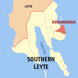
Map of Southern Leyte with Hinundayan highlighted
OpenStreetMap
Hinundayan
Philippines location map (square).svg
Red pog.svg
Hinundayan
Location within the Philippines
Coordinates: 10°21′N125°15′E / 10.35°N 125.25°E / 10.35; 125.25
Country Philippines
Region Eastern Visayas
Province Southern Leyte
District 2nd district
Founded March 21, 1876
Barangays 17 (see Barangays)
Government
[1]
  Type Sangguniang Bayan
   Mayor Evelyn T. Lee (NUP)
   Vice Mayor Edna A. Resma (NUP)
   Representative Christopherson Yap
   Municipal Council
Members
   Electorate 9,656 voters (2022)
Area
[2]
  Total59.90 km2 (23.13 sq mi)
Elevation
46 m (151 ft)
Highest elevation
519 m (1,703 ft)
Lowest elevation
−1 m (−3 ft)
Population
 (2020 census) [3]
  Total12,398
  Density210/km2 (540/sq mi)
   Households
3,402
Economy
   Income class 5th municipal income class
   Poverty incidence
23.16
% (2018) [4]
   Revenue 70.75 million (2020)
   Assets 219.9 million (2020)
   Expenditure 67.06 million (2020)
Service provider
  ElectricitySouthern Leyte Electric Cooperative (SOLECO)
Time zone UTC+8 (PST)
ZIP code
6609
PSGC
IDD : area code +63(0)53
Native languages Boholano dialect
Cebuano
Tagalog
Website www.hinundayan-sleyte.gov.ph

Hinundayan, officially the Municipality of Hinundayan (Kabalian: Lungsod san Hinundayan; Cebuano : Lungsod sa Hinundayan; Tagalog : Bayan ng Hinundayan), is a 5th class municipality in the province of Southern Leyte, Philippines. According to the Hinundayan has a total land area of 6,108 hectares or 61.08 square kilometers, comprising 17 barangays. 2020 census, it has a population of 12,398 people. [3]

Contents

Etymology

During the 17th century, there were Spanish sailors who by chance arrived at our shores in Barangay Sabang. At that time, the fisherfolks and villagers were very busy setting up "handayanans" or resting place for their outrigger canoes. These handayanans were made up of posts with horizontal rails which were a meter high from the ground where the canoes and other sea crafts were laid after use. When the Spanish sailors asked the villagers what was the name of the place, the villagers who were oblivious of the strange language thought that they were asked of what they were doing, so they simply answered in their own dialect, "handayanan among gibuhat para sa among baruto." The Spaniards noted the first word "Handayanan" as the name of the place, so they refer the place as such, which was later on distorted to "Hinundayan". Since then, this place was called Hinundayan.

History

Foundation

Before Hinunangan became a town, this and Hinundayan were part of the town of Abuyog. But when it was created a town on the 18th century, Hinundayan was part of its jurisdiction.

On March 21, 1876, the Governor of Leyte Jose Fernandez issued an Executive Order proclaiming Hinundayan a separate town, the first “Kapitan Municipal” was Don Sotero Tobio. But its townhood lasted only until the Revolutionary Period. When the American came, it became a barrio of Hinunangan again. The “Kapitan Municipal” at that time was Don Luis Lagumbay.

Due to the petition of some concerned Hinundayanons, Executive Order No. 59 was issued on July 31, 1909, signed by Governor General William Cameron Forbes and Act No. 986 proclaiming Hinundayan a separate town from Hinunangan.

Geography

Barangays

Hinundayan is politically subdivided into 17 barangays. Each barangay consists of puroks and some have sitios.

  • Amaga
  • Ambao
  • An-an
  • Baculod
  • Biasong
  • Bugho (Green Valley)
  • Cabulisan
  • Cat-iwing
  • District I (Poblacion)
  • District II (Poblacion)
  • District III (Poblacion)
  • Hubasan
  • Lungsodaan
  • Navalita
  • Plaridel
  • Sabang
  • Sagbok

Climate

Climate data for Hinundayan, Southern Leyte
MonthJanFebMarAprMayJunJulAugSepOctNovDecYear
Mean daily maximum °C (°F)28
(82)
29
(84)
29
(84)
30
(86)
30
(86)
30
(86)
29
(84)
29
(84)
29
(84)
29
(84)
29
(84)
29
(84)
29
(84)
Mean daily minimum °C (°F)22
(72)
22
(72)
23
(73)
23
(73)
25
(77)
25
(77)
25
(77)
25
(77)
25
(77)
25
(77)
24
(75)
23
(73)
24
(75)
Average precipitation mm (inches)78
(3.1)
57
(2.2)
84
(3.3)
79
(3.1)
118
(4.6)
181
(7.1)
178
(7.0)
169
(6.7)
172
(6.8)
180
(7.1)
174
(6.9)
128
(5.0)
1,598
(62.9)
Average rainy days16.713.817.318.523.226.527.126.026.427.524.621.0268.6
Source: Meteoblue [5]

Demographics

Population census of Hinundayan
YearPop.±% p.a.
1903 5,547    
1918 8,999+3.28%
1939 6,830−1.30%
1948 7,199+0.59%
1960 7,088−0.13%
1970 8,546+1.89%
1975 9,225+1.55%
1980 9,746+1.10%
1990 9,965+0.22%
1995 10,617+1.19%
2000 11,113+0.98%
2007 11,610+0.61%
2010 11,890+0.87%
2015 12,285+0.62%
2020 12,398+0.18%
Source: Philippine Statistics Authority [6] [7] [8] [9]

Among the seventeen (17) barangays of the municipality, four (4) barangays are considered urban and the remaining thirteen (13) barangays are rural. Based on the Philippine Statistics Authority (NSO), 2007 Census of Population, the municipality's population is dispersed in the rural barangays with a total population count of 7,692 or 66% of the total population while the remaining 34% or the 3,918 population count is concentrated in the urban barangays.

Economy

See also

Related Research Articles

<span class="mw-page-title-main">Albuera, Leyte</span> Municipality in Leyte, Philippines

Albuera, officially the Municipality of Albuera, is a 3rd class municipality in the province of Leyte, Philippines. According to the 2020 census, it has a population of 47,151 people.

<span class="mw-page-title-main">Padre Burgos, Southern Leyte</span> Municipality in Southern Leyte, Philippines

Padre Burgos, officially the Municipality of Padre Burgos, is a 5th class municipality in the province of Southern Leyte, Philippines. According to the 2020 census, it has a population of 11,159 people.

<span class="mw-page-title-main">Silago</span> Municipality in Southern Leyte, Philippines

Silago, officially the Municipality of Silago, is a 4th class municipality in the province of Southern Leyte, Philippines. According to the 2020 census, it has a population of 13,116 people. It was used to be barrio of Hinunangan until Executive Order No. 326 dated May 17, 1950 separated it from the mother town. The town has an ebony beach with unique black sand.

<span class="mw-page-title-main">Anahawan</span> Municipality in Southern Leyte, Philippines

Anahawan, officially the Municipality of Anahawan, is a 5th class municipality in the province of Southern Leyte, Philippines. According to the 2020 census, it has a population of 8,429 people.

<span class="mw-page-title-main">Hinunangan</span> Municipality in Southern Leyte, Philippines

Hinunangan, officially the Municipality of Hinunangan, is a 3rd class municipality in the province of Southern Leyte, Philippines. According to the 2020 census, it has a population of 29,149 people.

<span class="mw-page-title-main">Limasawa</span> Municipality in Southern Leyte, Philippines

Limasawa, officially the Municipality of Limasawa, is an island municipality in the province of Southern Leyte, Philippines. According to the 2020 census, it has a population of 6,191 people.

<span class="mw-page-title-main">Malitbog, Southern Leyte</span> Municipality in Southern Leyte, Philippines

Malitbog, officially the Municipality of Malitbog, is a 4th class municipality in the province of Southern Leyte, Philippines. According to the 2020 census, it has a population of 23,256 people.

<span class="mw-page-title-main">Pintuyan</span> Municipality in Southern Leyte, Philippines

Pintuyan, officially the Municipality of Pintuyan, is a 5th class municipality in the province of Southern Leyte, Philippines and was established in 1865. During the American regime, the seat of Pintuyan was moved to Pintuyan from San Ricardo upon the election of Perfecto Vazquez as Municipal President. From then on the residents of barrio San Ricardo petitioned for a separate municipality. According to the 2020 census, it has a population of 10,202 people.

<span class="mw-page-title-main">San Francisco, Southern Leyte</span> Municipality in Southern Leyte, Philippines

San Francisco, officially the Municipality of San Francisco, is a 5th class municipality in the province of Southern Leyte, Philippines. According to the 2020 census, it has a population of 13,436 people.

<span class="mw-page-title-main">San Juan, Southern Leyte</span> Municipality in Southern Leyte, Philippines

San Juan, officially the Municipality of San Juan, is a 5th class municipality in the province of Southern Leyte, Philippines. According to the 2020 census, it has a population of 14,912 people.

<span class="mw-page-title-main">San Ricardo</span> Municipality in Southern Leyte, Philippines

San Ricardo, officially the Municipality of San Ricardo, is a 5th class municipality in the province of Southern Leyte, Philippines. According to the 2020 census, it has a population of 10,500 people.

<span class="mw-page-title-main">Tomas Oppus</span> Municipality in Southern Leyte, Philippines

Tomas Oppus, officially the Municipality of Tomas Oppus, is a 5th class municipality in the province of Southern Leyte, Philippines. According to the 2020 census, it has a population of 16,990 people.

<span class="mw-page-title-main">Bato, Leyte</span> Municipality in Leyte, Philippines

Bato, officially the Municipality of Bato, is a 4th class municipality in the province of Leyte, Philippines. According to the 2020 census, it has a population of 38,505 people.

<span class="mw-page-title-main">Inopacan</span> Municipality in Leyte, Philippines

Inopacan, officially the Municipality of Inopacan, is a 4th class municipality in the province of Leyte, Philippines. According to the 2020 census, it has a population of 21,389 people.

<span class="mw-page-title-main">Isabel, Leyte</span> Municipality in Leyte, Philippines

Isabel, officially the Municipality of Isabel, is a 1st class municipality in the province of Leyte, Philippines. According to the 2020 census, it has a population of 46,781 people.

<span class="mw-page-title-main">Matag-ob</span> Municipality in Leyte, Philippines

Matag-ob, officially the Municipality of Matag-ob, is a 4th class municipality in the province of Leyte, Philippines. According to the 2020 census, it has a population of 17,522 people.

<span class="mw-page-title-main">Matalom</span> Municipality in Leyte, Philippines

Matalom, officially the Municipality of Matalom, is a 3rd class municipality in the province of Leyte, Philippines. According to the 2020 census, it has a population of 32,586 people.

<span class="mw-page-title-main">Palompon</span> Municipality in Leyte, Philippines

Palompon, officially the Municipality of Palompon, is a 2nd class municipality in the province of Leyte, Philippines. According to the 2020 census, it has a population of 58,313 people.

<span class="mw-page-title-main">San Isidro, Leyte</span> Municipality in Leyte, Philippines

San Isidro, officially the Municipality of San Isidro, is a 4th class municipality in the province of Leyte, Philippines. According to the 2020 census, it has a population of 30,722 people.

<span class="mw-page-title-main">San Miguel, Leyte</span> Municipality in Leyte, Philippines

San Miguel, officially the Municipality of San Miguel, is a 4th class municipality in the province of Leyte, Philippines. According to the 2020 census, it has a population of 19,753 people.

References

  1. Municipality of Hinundayan | (DILG)
  2. "2015 Census of Population, Report No. 3 – Population, Land Area, and Population Density" (PDF). Philippine Statistics Authority. Quezon City, Philippines. August 2016. ISSN   0117-1453. Archived (PDF) from the original on May 25, 2021. Retrieved July 16, 2021.
  3. 1 2 Census of Population (2020). "Region VIII (Eastern Visayas)". Total Population by Province, City, Municipality and Barangay. Philippine Statistics Authority . Retrieved 8 July 2021.
  4. "PSA Releases the 2018 Municipal and City Level Poverty Estimates". Philippine Statistics Authority. 15 December 2021. Retrieved 22 January 2022.
  5. "Hinundayan, Southern Leyte : Average Temperatures and Rainfall". Meteoblue. Retrieved 6 January 2019.
  6. Census of Population (2015). "Region VIII (Eastern Visayas)". Total Population by Province, City, Municipality and Barangay. Philippine Statistics Authority . Retrieved 20 June 2016.
  7. Census of Population and Housing (2010). "Region VIII (Eastern Visayas)" (PDF). Total Population by Province, City, Municipality and Barangay. National Statistics Office . Retrieved 29 June 2016.
  8. Censuses of Population (1903–2007). "Region VIII (Eastern Visayas)". Table 1. Population Enumerated in Various Censuses by Province/Highly Urbanized City: 1903 to 2007. National Statistics Office.{{cite encyclopedia}}: CS1 maint: numeric names: authors list (link)
  9. "Province of Southern Leyte". Municipality Population Data. Local Water Utilities Administration Research Division. Retrieved 17 December 2016.
  10. "Poverty incidence (PI):". Philippine Statistics Authority. Retrieved December 28, 2020.
  11. "Estimation of Local Poverty in the Philippines" (PDF). Philippine Statistics Authority. 29 November 2005.
  12. "2003 City and Municipal Level Poverty Estimates" (PDF). Philippine Statistics Authority. 23 March 2009.
  13. "City and Municipal Level Poverty Estimates; 2006 and 2009" (PDF). Philippine Statistics Authority. 3 August 2012.
  14. "2012 Municipal and City Level Poverty Estimates" (PDF). Philippine Statistics Authority. 31 May 2016.
  15. "Municipal and City Level Small Area Poverty Estimates; 2009, 2012 and 2015". Philippine Statistics Authority. 10 July 2019.
  16. "PSA Releases the 2018 Municipal and City Level Poverty Estimates". Philippine Statistics Authority. 15 December 2021. Retrieved 22 January 2022.