Cotabato

Last updated

Cotabato
North Cotabato
Other transcription(s)
   Jawi اوتار كوتوات
Mount Apo Rainforest.jpg
Paniki Falls side view located at Umpan, Village Barangay Balabag, Kidapawan City.jpg
Mount Apo.JPG
Lake venado.JPG
Road of gold.jpg
Cotabato Empire Provincial Capitol.jpg
(from top: left to right) Mount Apo Rainforest, Paniki Falls in Kidapawan, Lake Venado Campsite, Lake Venado, Provincial road in Carmen and Cotabato Provincial Capitol.
PH-NCO Flag.png
Ph seal cotabato.png
Cotabato in Philippines.svg
Location in the Philippines
OpenStreetMap
Cotabato
Coordinates: 7°12′N124°51′E / 7.2°N 124.85°E / 7.2; 124.85
Country Philippines
Region Soccsksargen*
Foundation
Capital
and largest city
Kidapawan
Government
   Governor Emmylou Taliño-Mendoza (NP)
   Vice Governor Efren F. Piñol (PDP–Laban)
   Legislature Cotabato Provincial Board
Area
[1]
  Total9,008.90 km2 (3,478.36 sq mi)
  Rank6th out of 81
Highest elevation2,954 m (9,692 ft)
Population
 (2020 census) [2]
  Total1,275,185
  Rank22nd out of 81
  Density140/km2 (370/sq mi)
   Rank57th out of 81
Divisions
   Independent cities 0
   Component cities
   Municipalities
   Barangays 606
   Districts Legislative districts of Cotabato
Time zone UTC+8 (PST)
ZIP code
9400–9417
IDD : area code +63(0)64
ISO 3166 code PH-NCO
Spoken languages
Income classification1st class
Website cotabatoprov.gov.ph

Cotabato, formerly and still commonly referred to as North Cotabato [lower-alpha 1] and officially the Province of Cotabato, is a landlocked province in the Philippines located in the Soccsksargen region in Mindanao. Its capital is the city of Kidapawan, the most populous in the province. Some of its municipalities are under the jurisdiction of the nearby Bangsamoro Autonomous Region.

Contents

Etymology

The name Kuta Watu in Maguindanaon (or Kota Batu in Malay) means "stone fortress".

7th-century urn made of limestone, from Cotabato Mindanao burial urn 2 SF Asian Art Museum.JPG
7th-century urn made of limestone, from Cotabato

History

Maguindanao Sultanate

According to Maguindanao royal records, Islam was introduced to the Maguindanaos in the late 15th century by Sharif Muhammad Kabungsuan, a Johorean Malay Muslim noble and missionary of Arab descent. Sharif Kabungsuan invaded Malabang in 1475, facing armed resistance from the principality, nevertheless successfully vanquishing and subjugating it to his Islamic rule through the employment of Samal forces. [3]

Cotabato became the capital of the Maguindanao Sultanate. The city became the seat of power of Sultan Muhammad Kudarat in 1619.

Spanish invasion

Christianity was introduced in 1596, but the Spaniards were unable to penetrate into the region until the second half of the 19th century. The district of Cotabato was formed in 1860, [4] covering the areas of what is now Cotabato, Maguindanao and Sultan Kudarat provinces with its capital at Tamontaka. Fort Pikit was established by the Spaniards in 1893 as they continued their conquest of the remnants of Maguindanao Sultanate, which would soon be the site of one of the province's oldest towns, Pikit.

American rule

The coming of the Americans ushered in the creation of the Moro Province on July 15, 1903, through Act No. 787 of the Philippine Commission. Cotabato, covering what are now the provinces of Cotabato, Maguindanao, Sultan Kudarat, South Cotabato and Sarangani, became a district of the huge Moro province. During the American period, large companies were established in Cotabato to exploit the vast timber resources of the region. By the 1930s, settlers from Luzon and Visayas established homesteads in Cotabato.

Japanese invasion

In December 1941, Japanese planes bombed and invaded Cotabato. In 1942, Cotabato was occupied by the Japanese Imperial forces. A military headquarters of the Philippine Commonwealth Army existed in Cotabato from January 3, 1942, to June 30, 1946, and the Philippine Constabulary 10th Constabulary Regiment was stationed in Cotobato from October 28, 1944, to June 30, 1946. Moro guerrilla fighters operating in the province of Cotabato helped local forces of the Philippine Commonwealth Army and the Philippine Constabulary 10th Constabulary Regiment fight against the Imperial Japanese Army until 1944. The Moro guerrillas fought the Japanese troops until liberation. In 1945, Cotabato was recaptured from the Japanese Imperial forces by the combined Filipino and American troops together with the recognized Moro guerrilla units. The guerrillas used the traditional Moro Kampilan, Barong and Kris swords as their weapons.

Postwar Era

The pace of settlement in the region accelerated in the 1950s and 1960s. The former province of Cotabato was once the largest in the Philippines. In 1966, South Cotabato was created as a separate province. [5]

Mindanao, including Cotabato, was relatively peaceful in the 1950s and the mid-1960s. While there were some ethnic tensions, there was essentially no presence of secessionist groups in Mindanao yet. [6]

During the Marcos dictatorship

The relative peace of the postwar era began to change in the last years of President Ferdinand Marcos' first term, when news about the Jabidah massacre ignited a furor in the Moro community, and ethnic tensions encouraged with the formation of secessionist movements. [7] None of these groups had enough followers to form a viable opposition until Marcos declared Martial Law, [8] but when political parties were dissolved upon the proclamation of Martial Law in September 1972, it became easy for the armed secessionist group known as the Moro National Liberation Front to consolidate power, and the decades-long Moro conflict began in earnest. [9]

One major event of Martial law which took place in Cotabato was the Manili massacre, which saw the mass murder of 70 [10] to 79 [11] Moros, including women and children, committed in a mosque in Manili, Carmen, North Cotabato, Philippines on June 19, 1971. [12] The Muslim residents of the town had gathered in their mosque to participate in a supposed peace talk with Christian groups when a group of armed men suspected to be part of the Ilaga militant group [10] opened fire on them. [12]

On November 22, 1973, through Presidential Decree No. 341, what remained of the old Cotabato was further divided into the provinces of North Cotabato, Maguindanao, and Sultan Kudarat. [13] North Cotabato was later renamed Cotabato through Batas Pambansa Blg. 660 approved on March 7, 1984. [14]

Fifth Philippine Republic era

By the aftermath of the plebiscite to form the autonomous administrative region of Bangsamoro in February 2019, 63 barangays from Cotabato's western municipalities, all of which inhabited mostly by Muslim natives, opted to join the newly formed region. [15] This will result in the reduction of the number of barangays the province currently administers after the national midterm elections on May 13, 2019. [16] Cotabato now comprises the capital city of Kidapawan and 25 municipalities.

Geography

Cotabato covers a total area of 9,008.90 square kilometres (3,478.36 sq mi) [17] occupying the northeastern tip of Region XII and is centrally located in Mindanao. It is bounded on the north by the provinces of Lanao del Sur and Bukidnon, on the east by Davao City and Davao del Norte, on the west by Maguindanao del Norte and Maguindanao del Sur, on the south by Sultan Kudarat, and on the southeast by Davao del Sur.

Cotabato is strategically linked to the major "Arterial Road System" that traverses and connects the province to Davao City - Soccsksargen - Cotabato Corridor. The Cotabato via Kabacan - Maramag - Kibawe, Bukidnon Sayre Highway meanwhile serves as its link to the Cagayan de Oro-Iligan City Corridor. The Pan-Philippine Highway (AH26) traverses through the municipalities of Midsayap, Libungan and the Pigcawayan.

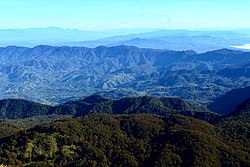
Cotabato stretches from the east at Mount Apo, which separates it from Davao, to the Piapayungan Range on its boundary with Lanao in the west. [18] Between these highlands is the basin of the Pulangi River or Rio Grande de Mindanao, [18] the second longest in the Philippines at 373 kilometres (232 mi), which rises in Bukidnon and flows south to Maguindanao and Illana Bay. The province's fertile plains are traversed by tributaries of this great river.

Typhoons do not pass through Cotabato and rainfall is evenly distributed throughout the year. [18]

Climate data for Cotabato
MonthJanFebMarAprMayJunJulAugSepOctNovDecYear
Mean daily maximum °C (°F)30.5
(86.9)
31.0
(87.8)
32.0
(89.6)
32.8
(91.0)
32.2
(90.0)
31.8
(89.2)
31.3
(88.3)
31.5
(88.7)
31.8
(89.2)
32.3
(90.1)
31.8
(89.2)
31.3
(88.3)
31.7
(89.0)
Mean daily minimum °C (°F)23.7
(74.7)
23.9
(75.0)
24.1
(75.4)
24.7
(76.5)
24.8
(76.6)
24.6
(76.3)
24.4
(75.9)
24.5
(76.1)
24.4
(75.9)
24.4
(75.9)
24.4
(75.9)
24.2
(75.6)
24.3
(75.8)
Average rainy days151113111517151413151513167
Source: Storm247 [19]

Administrative divisions

Cotabato comprises 25 municipalities and one city. [17] However, 8 municipalities are under the jurisdiction of Bangsamoro as part of its special geographic area.

Political map of Cotabato Map of Cotabato provinces with municipalities.svg
Political map of Cotabato
City or municipality District [17] Population (2020) [20] Area (km2)No. of Barangay(s) Coordinates [A]
Alamada 1st68,659787.5017 7°23′24″N124°32′59″E / 7.3900°N 124.5498°E / 7.3900; 124.5498 (Alamada)
Aleosan 1st36,892199.40917 7°09′08″N124°34′53″E / 7.1523°N 124.5813°E / 7.1523; 124.5813 (Aleosan)
Antipas 2nd26,817552.5013 7°14′42″N125°03′14″E / 7.2450°N 125.0539°E / 7.2450; 125.0539 (Antipas)
Arakan 2nd50,558693.2228 7°21′05″N125°07′34″E / 7.3514°N 125.1262°E / 7.3514; 125.1262 (Arakan)
Banisilan 3rd46,995577.2220 7°30′21″N124°41′41″E / 7.5058°N 124.6947°E / 7.5058; 124.6947 (Banisilan)
Carmen 3rd79,140929.8121 7°12′16″N124°47′43″E / 7.2045°N 124.7953°E / 7.2045; 124.7953 (Carmen)
Kabacan 3rd77,164448.0917 7°07′00″N124°49′00″E / 7.1166°N 124.8166°E / 7.1166; 124.8166 (Kabacan)
Kadayangan SGA [lower-alpha 2] 25,57341.607 7°07′23″N124°28′34″E / 7.1230°N 124.4761°E / 7.1230; 124.4761 (Kadayangan)
Kapalawan SGA [lower-alpha 2] 28,643180.627 7°15′38″N124°47′21″E / 7.2605°N 124.7893°E / 7.2605; 124.7893 (Kapalawan)
Kidapawan City 2nd160,791358.4740 7°00′30″N125°05′30″E / 7.0083°N 125.0916°E / 7.0083; 125.0916 (Kidapawan)
Libungan 1st56,269172.5020 7°14′25″N124°31′11″E / 7.2403°N 124.5198°E / 7.2403; 124.5198 (Libungan)
Ligawasan SGA [lower-alpha 2] 29,784111.607 6°59′42″N124°42′18″E / 6.9951°N 124.7050°E / 6.9951; 124.7050 (Ligawasan)
Magpet 2nd53,800755.3632 7°06′08″N125°07′28″E / 7.1023°N 125.1245°E / 7.1023; 125.1245 (Magpet)
Makilala 2nd87,927343.5738 6°57′41″N125°05′09″E / 6.9613°N 125.0858°E / 6.9613; 125.0858 (Makilala)
Malidegao SGA [lower-alpha 2] 36,438115.457 7°10′27″N124°41′26″E / 7.1741°N 124.6906°E / 7.1741; 124.6906 (Malidegao)
Matalam 3rd81,355476.0034 6°57′41″N125°05′09″E / 6.9613°N 125.0858°E / 6.9613; 125.0858 (Matalam)
Midsayap 1st117,365186.4744 7°11′21″N124°32′06″E / 7.1891°N 124.5349°E / 7.1891; 124.5349 (Midsayap)
M'lang 3rd98,195312.1337 6°56′47″N124°52′42″E / 6.9463°N 124.8783°E / 6.9463; 124.8783 (M'lang)
Nabalawag SGA [lower-alpha 2] 28,23986.057 7°05′55″N124°29′36″E / 7.0985°N 124.4932°E / 7.0985; 124.4932 (Nabalawag)
Old Kaabakan SGA [lower-alpha 2] 16,658117.177 7°09′51″N124°50′44″E / 7.1642°N 124.8455°E / 7.1642; 124.8455 (Old Kaabakan)
Pahamuddin SGA [lower-alpha 2] 19,62750.1312 7°10′06″N124°21′52″E / 7.1684°N 124.3645°E / 7.1684; 124.3645 (Pahamuddin)
Pigcawayan 1st52,744289.9828 7°16′45″N124°25′27″E / 7.2791°N 124.4242°E / 7.2791; 124.4242 (Pigcawayan)
Pikit 1st67,024277.2720 7°03′13″N124°40′20″E / 7.0537°N 124.6722°E / 7.0537; 124.6722 (Pikit)
President Roxas 2nd52,512618.2525 7°09′15″N125°03′19″E / 7.1543°N 125.0554°E / 7.1543; 125.0554 (President Roxas)
Tugunan SGA [lower-alpha 2] 30,651102.609 7°02′25″N124°36′44″E / 7.0403°N 124.6121°E / 7.0403; 124.6121 (Tugunan)
Tulunan 3rd60,978343.0829 6°49′50″N124°52′22″E / 6.8305°N 124.8728°E / 6.8305; 124.8728 (Tulunan)
Total1,275,1859,008.90543
  1. Hiligaynon: Aminhan Cotabato; Maguindanaon: Utara Kutawatu, Jawi: اوتار كوتوات; Cebuano: Amihanang Cotabato; Cebuano: Amihanang Cotabato; Ilocano: Amianan a Cotabato; Filipino: Hilagang Cotabato)
  2. 1 2 3 4 5 6 7 8 The municipalities of Kadayangan, Kapalawan, Ligawasan, Malidegao, Nabalawag, Old Kaabakan, Pahamuddin and Tugunan are under the administration of Bangsamoro as part of its special geographic area despite being geographically grouped under the province of Cotabato. [lower-alpha 3] [lower-alpha 4]
  3. "BARMM approves creation of 8 new towns". Manila Bulletin. Retrieved August 19, 2023.
  4. "Bills creating 8 municipalities in SGA-BARMM approved by BTA Parliament". Luwaran. August 20, 2023. Retrieved August 25, 2023.

Reduction due to the establishment of the Bangsamoro

During the 2001 Referendum for inclusion to the Autonomous Region in Muslim Mindanao, 2 out of 28 barangays of Carmen, Cotabato chose to be part of ARMM, but were excluded because they are not connected to the main region of ARMM. During 2010-2016 Administration, the Bangsamoro ideal sprouted and a newly proposed region was in the making. According to the agreements signed by the Moro Islamic Liberation Front and the Administration of Noynoy Aquino, Carmen will be included in Bangsamoro because of the two out of twenty-eight barangays that voted in favor of joining the Muslim region back in 2001. Unfortunately, Bangsamoro was not implemented before the term of Aquino ended. Despite this, the current administration aims to establish a Federal Government, where Bangamoro will be realized into a State of the Philippines wherein Carmen will be included in Bangsamoro.

Plans to establish a new municipality in the south of Carmen so that the indigenous and Christian central and northern part of Carmen will be retained in North Cotabato has yet to be confirmed. The idea arose because once the entire municipality of Carmen is included in Bangsamoro, the province of North Cotabato will be cut into half, leaving three towns (Banisilan, Alamada, and Libungan) at its west without connection to the center of North Cotabato, isolating these towns in the process.

The issue was partially resolved when the second part of the plebiscite was conducted on February 6, 2019, when 63 barangay from the towns of Pigkawayan, Libungan, Midsayap, Aleosan, Carmen, Banisilan and Pikit opted to join the new administrative autonomous region of Bangsamoro after the results of the region's formation plebiscite were confirmed three days later on February 9. [15] These barangays are to join either the adjacent province of Maguindanao as parts of the said province's nearby and respective municipalities or to cluster on their own as new municipalities within the said province after the national midterm elections on May 13, 2019. [16] The size and population of Cotabato province had officially diminished on November 20, 2019, as the barangays which voted to join the Bangsamoro made their exit from the province and their respective mother municipalities and were officially turned over to the Bangsamoro government as an interim province within the autonomous region divided into several clusters. [21] [22]

Demographics

Population census of Cotabato
YearPop.±% p.a.
1903 3,988    
1918 16,165+9.78%
1939 50,012+5.53%
1948 87,236+6.38%
1960 279,478+10.19%
1970 468,354+5.29%
1975 472,302+0.17%
1980 564,599+3.63%
1990 763,995+3.07%
1995 862,666+2.30%
2000 958,643+2.29%
2007 1,121,974+2.19%
2010 1,226,508+3.29%
2015 1,379,747+2.27%
2020 1,275,185−1.54%
Source: Philippine Statistics Authority [23] [24] [25] [26]
2020 Census count was revised as per PSA Board Resolution
No. 13 Series of 2021 adopted on November 9, 2021. [20] [21]
Spoken languages in Cotabato
Languagespercentage
Hiligaynon
46%
Maguindanao
38%
Cebuano
8%
Ilocano
4%

Based on the 2020 census, Cotabato has an overall population of 1,275,185. [2] The average population growth rate was 2.27% in the period 2010–2015, which is higher than the national average of 1.72%. The province had a density of 140 inhabitants per square kilometre or 360 inhabitants per square mile.

Cotabato is an ethnolinguistically diverse province. The first Visayan settlers reached the town of Pikit in 1913, and since then, Christian migrants have moved and lived in Cotabato, cohabitating the province with the local indigenous groups. 71% of Cotabato's population descended from settlers who migrated from the Visayas and Luzon, while the remaining 18% belong to the communities of Magindanaons, Iranuns, Ilianens, Dulangan Manobo, Obo, Tagabawa, and Tboli. The major languages spoken are Hiligaynon (46%), Maguindanao (38%), Cebuano (8%), and Ilocano (4%). [18]

Religion

Religion in Cotabato (2020) [27] [nb 1]
Religionpercentage
Catholic
52.77%
Islam
19.32%
Southern Baptist Church
3.73%
Iglesia ni Cristo
2.2%
Others
21.98%
  1. Excludes 63 barangays under the Special Geographic Area

Catholicism

Cotabato's population is predominantly Catholic. According to the 2020 census, [28] 52.77% of the population are Roman Catholic. [29]

Islam

Muslims form 26% of the population. [30] In 2015, the Philippine Statistics Authority recorded Islam followed by 39.28% of the population. [31] Later in 2020, Islam form 19% of the population. [32]

Others

The other significant minorities are Evangelical Christians at 8.4% of the population, Southern Baptist Church with 3.7% of the population, and Iglesia Ni Cristo which forms 2.2% of the Province population. [33]

Economy

Poverty incidence of Cotabato

10
20
30
40
50
60
2006
31.38
2009
30.64
2012
52.36
2015
43.17
2018
29.25
2021
23.60

Source: Philippine Statistics Authority [34] [35] [36] [37] [38] [39] [40] [41]

Cotabato is considered a major food basket in Mindanao. It is a top producer of cereals, tropical fruits, vegetables, sugarcane, coconut, coffee, freshwater fish and livestock.

It is also one of the country's leading producers of raw and semi-processed rubber and industrial trees, [42] with markets in Asia and Europe.

Among its major natural assets are Mt. Apo, the country's highest peak at 9,692 feet (2,954 m) above sea level, the Pulangi River which is a major contributor to Mindanao's irrigation system and hydro-electric energy, and the vast Liguasan Marsh which not only supplies a bounty of freshwater fish and organic fertilizer but considered as a possible source as well of natural gas.

Power utility in the province comes from two energy sources - the NAPOCOR Agus Grid in Iligan transmitted through its Tacurong Substations and the Mount Apo Geothermal Power Plant at the foot of Mt. Apo in Ilomavis, Kidapawan City which produces 97 megawatts of electricity. Power distribution is handled by Cotabato Electric Cooperative, Inc. (COTELCO).

The province has a 4,131.32-kilometre (2,567.08 mi) road network connecting the major centers to each other and the outlying barangays, and communication linkage through NDD-IDD, fax, cellular phone and the internet is available.

Government

President Benigno Aquino III signed the law dividing to new 3 legislative district of Cotabato on September 14, 2012. The representative shall continue to serve until next national election. [43]

Elected provincial officials

  1. 1st District — Rep. Joselito S. Sacdalan
  2. 2nd District — Rep. Rudy Caodagan
  3. 3rd District — Rep. Maria Alana Samantha Talino Santos

Notable people

Notes

    Related Research Articles

    <span class="mw-page-title-main">Maguindanao</span> Philippine province (1973–2022)

    Maguindanao was a province of the Philippines located in the Bangsamoro Autonomous Region in Muslim Mindanao (BARMM). From 2014 to 2022, its provincial capital was Buluan, but the legislative branch of government, the Maguindanao Provincial Board, convened at the old provincial capitol in Sultan Kudarat. It bordered Lanao del Sur to the north, Cotabato to the east, Sultan Kudarat to the south, and Illana Bay to the west.

    <span class="mw-page-title-main">Sultan Kudarat</span> Province in Soccsksargen, Philippines

    Sultan Kudarat, officially the Province of Sultan Kudarat, is a province in the Philippines located in the Soccsksargen region in Mindanao. Its capital is Isulan while the commercial center and largest city is Tacurong.

    <span class="mw-page-title-main">Soccsksargen</span> Region in Mindanao, Philippines

    Soccsksargen, formerly known as Central Mindanao, is an administrative region of the Philippines, designated as Region XII. Located in south-central Mindanao, its name is an acronym that stands for the region's four provinces and one highly urbanized city. The regional center is in Koronadal, located in the province of Cotabato del Sur, and the center of commerce and industry is General Santos, which is the most populous city in the region.

    <span class="mw-page-title-main">Cotabato City</span> Independent component city in Maguindanao del Norte, Philippines

    Cotabato City, officially the City of Cotabato, is a first class independent component city in the Bangsamoro Autonomous Region in Muslim Mindanao, Philippines. According to the 2020 census, it has a population of 325,079 people, making it as the most populated city under the independent component city status.

    <span class="mw-page-title-main">Pikit</span> Municipality in Cotabato, Philippines

    Pikit, officially the Municipality of Pikit is a 1st class municipality in the province of Cotabato, Philippines. According to the 2020 census, it has a population of 67,024 people.

    <span class="mw-page-title-main">Alamada</span> Municipality in Cotabato, Philippines

    Alamada, officially the Municipality of Alamada, is a 1st class municipality in the province of Cotabato, Philippines. According to the 2020 census, it has a population of 68,659 people.

    <span class="mw-page-title-main">Aleosan</span> Municipality in Cotabato, Philippines

    Aleosan, officially the Municipality of Aleosan, is a 3rd class municipality in the province of Cotabato, Philippines. According to the 2020 census, it has a population of 36,892 people.

    <span class="mw-page-title-main">Banisilan</span> Municipality in Cotabato, Philippines

    Banisilan, officially the Municipality of Banisilan, is a 2nd class municipality in the province of Cotabato, Philippines. According to the 2020 census, it has a population of 46,995 people.

    <span class="mw-page-title-main">Carmen, Cotabato</span> Municipality in Cotabato, Philippines

    Carmen, officially the Municipality of Carmen, is a 1st class municipality in the province of Cotabato, Philippines. According to the 2020 census, it has a population of 79,140 people.

    <span class="mw-page-title-main">Kabacan</span> Municipality in Cotabato, Philippines

    Kabacan officially the Municipality of Kabacan, is a 1st class municipality in the province of Cotabato, Philippines. According to the 2020 census, it has a population of 77,164 people.

    <span class="mw-page-title-main">Midsayap</span> Municipality in Cotabato, Philippines

    Midsayap, officially the Municipality of Midsayap, is a 1st class municipality in the Province of Cotabato, Philippines. According to the 2020 census, it has a population of 117,365 people.

    <span class="mw-page-title-main">Pigcawayan</span> Municipality in Cotabato, Philippines

    Pigcawayan, officially the Municipality of Pigcawayan, is a 1st class municipality in the province of Cotabato, Philippines. According to the 2020 census, it has a population of 52,744 people.

    <span class="mw-page-title-main">Ampatuan, Maguindanao del Sur</span> Municipality in Maguindanao del Sur, Philippines

    Ampatuan, officially the Municipality of Ampatuan, is a 4th class municipality in the province of Maguindanao del Sur, Philippines. According to the 2020 census, it has a population of 28,941 people.

    <span class="mw-page-title-main">Datu Odin Sinsuat</span> Capital of Maguindanao del Norte, Philippines

    Datu Odin Sinsuat, officially the Municipality of Datu Odin Sinsuat, is a 2nd class municipality and capital of the province of Maguindanao del Norte, Philippines. According to the 2020 census, it has a population of 116,768 people.

    <span class="mw-page-title-main">Shariff Aguak</span> Municipality in Maguindanao del Sur, Philippines

    Shariff Aguak, officially the Municipality of Shariff Aguak, is a 3rd class municipality in the province of Maguindanao del Sur, Philippines. According to the 2020 census, it had a population of 33,982.

    <span class="mw-page-title-main">Sultan Kudarat, Maguindanao del Norte</span> Municipality in Maguindanao del Norte, Philippines

    Sultan Kudarat, officially the Municipality of Sultan Kudarat, is a 1st class municipality of the province of Maguindanao del Norte, Philippines. At the 2020 census it had a population of 105,121.

    <span class="mw-page-title-main">Parang, Maguindanao del Norte</span> Municipality in Maguindanao del Norte, Philippines

    Parang, officially the Municipality of Parang, is a 1st class municipality in the province of Maguindanao del Norte, Philippines. According to the 2020 census, it has a population of 102,914 people.

    <span class="mw-page-title-main">Pagalungan</span> Municipality in Maguindanao del Sur, Philippines

    Pagalungan, officially the Municipality of Pagalungan, is a 1st class municipality in the province of Maguindanao del Sur, Bangsamoro, Philippines. According to the 2020 census, it has a population of 46,277 people.

    <span class="mw-page-title-main">Bangsamoro</span> Autonomous region of the Philippines

    Bangsamoro, officially the Bangsamoro Autonomous Region in Muslim Mindanao, is an autonomous region in the Philippines, located in the southwestern portion of the island of Mindanao.

    <span class="mw-page-title-main">Special Geographic Area</span> Place in Bangsamoro, Philippines

    The Special Geographic Area (SGA) is a loose collection of 63 barangays in six municipalities of the province of Cotabato in the Philippines. It is part of the Bangsamoro Autonomous Region in Muslim Mindanao, despite the province of Cotabato itself being part of a separate neighboring region, Soccsksargen.

    References

    1. "List of Provinces". PSGC Interactive. Makati, Philippines: National Statistical Coordination Board. Archived from the original on January 17, 2013. Retrieved June 3, 2014.
    2. 1 2 Census of Population (2020). "Region XII (Soccsksargen)". Total Population by Province, City, Municipality and Barangay. Philippine Statistics Authority . Retrieved July 8, 2021.
    3. Halili, Christine N. (2004). "The Natural Setting and its People". Philippine History (First ed.). Manila, Philippines: Rex Book Store. pp. 52–53. ISBN   971-23-3934-3 . Retrieved April 29, 2016.
    4. "Our Province". Province of Cotabato (government website). Retrieved April 29, 2016.
    5. "Republic Act No. 4849 - An Act Creating the Province of South Cotabato". Chan Robles Virtual Law Library. July 18, 1966. Retrieved April 27, 2016.
    6. Miclat, Gus (2002). "Our lives were never the same again". In Arguillas, Carolyn O. (ed.). Turning rage into courage: Mindanao under martial law. MindaNews Publications, Mindanao News and Information Cooperative Center. OCLC   644320116.
    7. George, T. J. S. (1980). Revolt in Mindanao: the rise of Islam in Philippine politics. Kuala Lumpur. ISBN   0-19-580429-5. OCLC   6569089.{{cite book}}: CS1 maint: location missing publisher (link)
    8. George, T. J. S. (1980). Revolt in Mindanao: The Rise of Islam in Philippine Politics. Oxford University Press. pp. 130–134.
    9. Yegar, Moshe (2002). Between Integration and Secession: The Muslim Communities of the Southern Philippines, Southern Thailand and Western Burma/Myanmar. Lexington Books. pp. 267–268.
    10. 1 2 Mariveles, Julius D. "Mindanao: A memory of massacres". Archived from the original on March 3, 2016. Retrieved May 23, 2016.
    11. Arguillas, Carolyn O. (January 28, 2010). "De Lima: "Oooops, sorry, it's Ampatuan Massacre not Maguindanao Massacre". MindaNews. Archived from the original on March 4, 2016. Retrieved May 23, 2016.
    12. 1 2 Larousse, William (2001). A Local Church Living for Dialogue: Muslim-Christian Relations in Mindanao-Sulu, Philippines 1965–2000. Gregorian Biblical BookShop. p. 136. ISBN   88-7652-879-2.
    13. "Presidential Decree No. 341: Creating the Provinces of North Cotabato, Maguindanao and Sultan Kudarat". Philippine Laws, Statutes & Codes. Chan Robles Virtual Law Library. November 22, 1973. Retrieved May 27, 2014.
    14. "Batas Pambansa Blg. 660 - An Act Changing the Name of the Province of North Cotabato to Cotabato". Philippine Laws, Statutes & Codes. Chan Robles Virtual Law Library. November 22, 1973. Retrieved May 27, 2014.
    15. 1 2 "63 North Cotabato villages complete new Bangsamoro region". CNN Philippines . Archived from the original on February 17, 2019. Retrieved February 14, 2019.
    16. 1 2 Carolyn O. Arguillas (February 8, 2019). "Pikit's fate: 20 barangays remain with North Cotabato, 22 joining BARMM". MindaNews. Retrieved February 8, 2019.
    17. 1 2 3 "Province: Cotabato". PSGC Interactive. Quezon City, Philippines: Philippine Statistics Authority . Retrieved January 8, 2016.
    18. 1 2 3 4 Lancion, Conrado M. Jr. (1995). "The Provinces; Cotabato". Fast Facts about Philippine Provinces. cartography by de Guzman, Rey (The 2000 Millenium ed.). Makati, Metro Manila, Philippines: Tahanan Books. p. 64. ISBN   971-630-037-9 . Retrieved April 29, 2016.
    19. "Weather forecast for North Cotabato, Philippines". Storm247.com. Bergen, NO: StormGeo AS. Archived from the original on January 5, 2017. Retrieved April 29, 2016.
    20. 1 2 Total Population, Household Population, Number of Households, and Average Household Size by Region, Province, and City/Municipality: Philippines, 2020. PSA. March 23, 2022.
    21. 1 2 "PSA Board Resolution No. 13, Series of 2021: Approving and Adopting the Third Quarter 2021 Philippine Standard Geographic Code Updates to Include the Bangsamoro Autonomous Region in Muslim Mindanao (Barmm) and Correct the Names of 37 Barangays" (PDF). Philippine Statistics Authority. 2021. Retrieved April 1, 2022.
    22. Macabalang, Ali (November 13, 2019). "BARMM to assume official supervision over 63 NorCot villages on Nov. 20". Manila Bulletin. Archived from the original on November 13, 2019. Retrieved November 13, 2019.
    23. Census of Population (2015). "Region XII (Soccsksargen)". Total Population by Province, City, Municipality and Barangay. Philippine Statistics Authority . Retrieved June 20, 2016.
    24. Census of Population and Housing (2010). "Region XII (Soccsksargen)" (PDF). Total Population by Province, City, Municipality and Barangay. National Statistics Office . Retrieved June 29, 2016.
    25. Censuses of Population (1903–2007). "Region XII (Soccsksargen)". Table 1. Population Enumerated in Various Censuses by Province/Highly Urbanized City: 1903 to 2007. National Statistics Office.
    26. "Province of North Cotabato". Municipality Population Data. Local Water Utilities Administration Research Division. Retrieved December 17, 2016.
    27. "Religious Affiliation in the Philippines (2020 Census of Population and Housing) | Philippine Statistics Authority | Republic of the Philippines". psa.gov.ph. Retrieved August 6, 2023.
    28. https://psa.gov.ph/sites/default/files/NORTH%20COTABATO_FINAL%20PDF.pdf [ bare URL PDF ]
    29. Bueza, Michael (January 18, 2015). "MAP: Catholicism in the Philippines". Rappler.
    30. Bueza, Michael (July 17, 2015). "MAP: Islam in the Philippines". Rappler.
    31. Philippine Statistics Authority (July 26, 2017). "Muslim Population in Mindanao (based on POPCEN 2015". Archived from the original on May 4, 2019. Retrieved August 31, 2018.
    32. Table for religious affiliation psa.gov.ph
    33. Bueza, Michael (July 26, 2014). "MAP: Iglesia ni Cristo in the Philippines". Rappler.
    34. "Poverty incidence (PI):". Philippine Statistics Authority. Retrieved December 28, 2020.
    35. "Estimation of Local Poverty in the Philippines" (PDF). Philippine Statistics Authority. November 29, 2005.
    36. "2009 Official Poverty Statistics of the Philippines" (PDF). Philippine Statistics Authority. February 8, 2011.
    37. "Annual Per Capita Poverty Threshold, Poverty Incidence and Magnitude of Poor Population, by Region and Province: 1991, 2006, 2009, 2012 and 2015". Philippine Statistics Authority. August 27, 2016.
    38. "Annual Per Capita Poverty Threshold, Poverty Incidence and Magnitude of Poor Population, by Region and Province: 1991, 2006, 2009, 2012 and 2015". Philippine Statistics Authority. August 27, 2016.
    39. "Annual Per Capita Poverty Threshold, Poverty Incidence and Magnitude of Poor Population, by Region and Province: 1991, 2006, 2009, 2012 and 2015". Philippine Statistics Authority. August 27, 2016.
    40. "Updated Annual Per Capita Poverty Threshold, Poverty Incidence and Magnitude of Poor Population with Measures of Precision, by Region and Province: 2015 and 2018". Philippine Statistics Authority. June 4, 2020.
    41. "2021 Full Year Official Poverty Statistics of the Philippines" (PDF). Philippine Statistics Authority. August 15, 2022. Retrieved April 28, 2024.
    42. Cabrera, Ferdinandh B. (August 22, 2013). "NorthCot pushes rubber industry dev't". MindaNews. Mindanao News and Information Cooperative Center (MNICC). Retrieved April 29, 2016. North Cotabato is the country's second largest rubber producer, next to Zamboanga Sibugay, with a rubber plantation area of at least 55,000 hectares.
    43. Burgonio, TJ (September 15, 2012). "Aquino signs law reapportioning Cotabato into 3 districts". Philippine Daily Inquirer . Retrieved December 16, 2015.