Banga, South Cotabato

Last updated • 4 min readFrom Wikipedia, The Free Encyclopedia
Banga
Municipality of Banga
Other transcription(s)
   Jawi باڠ
Banga Plaza td (2018-12-26) 09.jpg
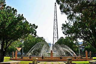
Banga Municipal Plaza in 2018
Flag of Banga, South Cotabato.png
Seal of Banga.png
Ph locator south cotabato banga.png
Map of South Cotabato with Banga highlighted
OpenStreetMap
Banga, South Cotabato
Philippines location map (square).svg
Red pog.svg
Banga
Location within the Philippines
Coordinates: 6°18′N124°47′E / 6.3°N 124.78°E / 6.3; 124.78
Country Philippines
Region Soccsksargen
Province South Cotabato
District 2nd district
Founded September 11, 1953
Barangays 22 (see Barangays)
Government
[1]
  Type Sangguniang Bayan
   Mayor Albert D. Palencia
   Vice Mayor Gemma I. Lloren
   Representative Ferdinand L. Hernandez
   Electorate 54,847 voters (2022)
Area
[2]
  Total
240.35 km2 (92.80 sq mi)
Elevation
169 m (554 ft)
Highest elevation
333 m (1,093 ft)
Lowest elevation
106 m (348 ft)
Population
 (2020 census) [3]
  Total
89,164
  Density370/km2 (960/sq mi)
   Households
23,266
Economy
   Income class 1st municipal income class
   Poverty incidence
20.04
% (2021) [4]
   Revenue 293.6 million (2020)
   Assets 676.1 million (2020)
   Expenditure 269.8 million (2020)
   Liabilities 206.5 million (2020)
Service provider
  ElectricitySouth Cotabato 1 Electric Cooperative (SOCOTECO 1)
Time zone UTC+8 (PST)
ZIP code
9511
PSGC
IDD : area code +63(0)83
Native languages Hiligaynon
Cebuano
Maguindanao
Blaan
Tagalog
Website bangascot.gov.ph/index.php

Banga, officially the Municipality of Banga (Hiligaynon : Banwa sang Banga; Cebuano : Lungsod sa Banga; Tagalog : Bayan ng Banga; Maguindanaon : Inged nu Banga, Jawi: ايڠد نو باڠ), is a municipality in the province of South Cotabato, Philippines. According to the 2020 census, it has a population of 89,164 people. [3]

Contents

Banga is situated at the north-west of the province of South Cotabato. The town derived its name from a palm tree known to the natives of the place as "Buanga" which during the pre-settlement time, predominantly grew in the area.

Banga is linked by a concrete national highway road from General Santos to the east and Cotabato City in the west. The town is known for its spacious town plaza, its public market is situated in the heart of the town and ideally zonified. Water for households and commercial use is abundant and the best source to it is Banga River which narrowly dissects the municipality.

It is the leading corn producer in the province and has made extraordinary achievements in terms of producing corn husk products for the local market.

It is also blessed with rich resources such as livestock and rice and has shown potential for mango. Pineapple and banana production while endowed with big rice mills, metal craft potentials, places suited for inland fishing and some residential development.

Banga works under the slogan “Cooperative Efforts towards Peace and Progress” and it is targeting to rapidly lift its economy to the highest level.

Banga strives to sustaining self-sufficiency and increasing agricultural production. It currently aims for the diversification and intensification of traditional agricultural practices, advocacy of food sufficiency method such as vegetable and fruit planting, poultry and livestock development within family farms, intensification on agricultural nurseries for a high yielding variety of crops, strengthening of information dissemination of appropriate technology to all farmers in the Barangay's by providing effective seminars, workshop and training in proper management of farmer's cooperative.

History

It started as a Settlement District of the Allah Valley Project of the National Land Settlement Administration (NLSA) on March 4, 1941, with Gen. Paulino Santos as the General Manager. On September 11, 1953, by way of Presidential Proclamation No. 612 of the then President Elpidio Quirino, it was emancipated as a barrio of Koronadal and became an independent municipal entity.

Geography

Barangays

Banga is politically subdivided into 22 barangays. Each barangay consists of puroks while some have sitios.

  • Benitez (Poblacion)
  • Cabudian
  • Cabuling
  • Cinco (Barrio 5)
  • Derilon
  • El Nonok
  • Improgo Village (Poblacion)
  • Kusan (Barrio 8)
  • Lam-Apos
  • Lamba
  • Lambingi
  • Lampari
  • Liwanay (Barrio 1)
  • Malaya (Barrio 9)
  • Punong Grande (Barrio 2)
  • Rang-ay (Barrio 4)
  • Reyes (Poblacion)
  • Rizal (Barrio 3)
  • Rizal Poblacion
  • San Jose (Barrio 7)
  • San Vicente (Barrio 6)
  • Yangco Poblacion

Climate

Climate data for Banga, South Cotabato
MonthJanFebMarAprMayJunJulAugSepOctNovDecYear
Mean daily maximum °C (°F)30
(86)
30
(86)
31
(88)
31
(88)
30
(86)
29
(84)
28
(82)
29
(84)
29
(84)
29
(84)
29
(84)
30
(86)
30
(85)
Mean daily minimum °C (°F)23
(73)
23
(73)
23
(73)
24
(75)
24
(75)
24
(75)
24
(75)
24
(75)
24
(75)
24
(75)
24
(75)
23
(73)
24
(74)
Average precipitation mm (inches)146
(5.7)
121
(4.8)
164
(6.5)
212
(8.3)
347
(13.7)
397
(15.6)
364
(14.3)
366
(14.4)
302
(11.9)
308
(12.1)
280
(11.0)
192
(7.6)
3,199
(125.9)
Average rainy days16.715.519.422.729.028.927.927.526.528.127.222.6292
Source: Meteoblue [5]

Demographics

Population census of Banga
YearPop.±% p.a.
1960 36,468    
1970 36,319−0.04%
1975 43,452+3.66%
1980 50,460+3.03%
1990 59,743+1.70%
1995 66,571+2.05%
2000 69,131+0.81%
2007 73,355+0.82%
2010 76,343+1.46%
2015 83,989+1.83%
2020 89,164+1.18%
Source: Philippine Statistics Authority [6] [7] [8] [9]

Economy

Poverty incidence of Banga

10
20
30
40
2006
30.60
2009
31.26
2012
30.85
2015
34.41
2018
19.50
2021
20.04

Source: Philippine Statistics Authority [10] [11] [12] [13] [14] [15] [16] [17]

Agriculture is the major economy of Banga. Corn, livestock, rice mango production potential, pine- apple, bananas, big rice mills, metal craft, inland fishing residential development. .

Festivals

Pasundayag Festival – 1st Week of March

Pasundayag, an Ilonggo term which means “show” or “presentation” is a unique fiesta celebration which showcases the municipality's local talents in a week-long celebration of good life and thanksgiving of the people of Banga.

Banga, the corn production center of South Cotabato, celebrates its foundation every 1st Week of March with a colorful Pasundayag festival a showcase of merry-making activities with its week-long events of beer and food festivals, street dancing competition, beauty pageant, trade fare, bargain shops and street parties.

Tourism

Education

Secondary:

Elementary:

Notable personalities

Related Research Articles

<span class="mw-page-title-main">Kalamansig</span> Municipality in Sultan Kudarat, Philippines

Kalamansig, officially the Municipality of Kalamansig, is a municipality in the province of Sultan Kudarat, Philippines. According to the 2020 census, it has a population of 50,900 people.

<span class="mw-page-title-main">Esperanza, Sultan Kudarat</span> Municipality in Sultan Kudarat, Philippines

Esperanza, officially the Municipality of Esperanza ; Tagalog: Bayan ng Esperanza, is a municipality in the province of Sultan Kudarat, Philippines. According to the 2020 census, it has a population of 74,696 people.

<span class="mw-page-title-main">Isulan</span> Capital of Sultan Kudarat, Philippines

Isulan, officially the Municipality of Isulan, is a municipality and capital of the province of Sultan Kudarat, Philippines. According to the 2020 census, it has a population of 97,490 people.

<span class="mw-page-title-main">Koronadal</span> Capital of South Cotabato, Philippines

Koronadal, officially the City of Koronadal and also known as Marbel, is a 1st Class component city and capital of the province of South Cotabato, Philippines. According to the 2020 census, it has a population of 195,398 people.

<span class="mw-page-title-main">Antipas, Cotabato</span> Municipality in Cotabato, Philippines

Antipas, officially the Municipality of Antipas, is a municipality in the province of Cotabato, Philippines. According to the 2020 census, it has a population of 26,817 people.

<span class="mw-page-title-main">Kabacan</span> Municipality in Cotabato, Philippines

Kabacan officially the Municipality of Kabacan, is a municipality in the province of Cotabato, Philippines. According to the 2020 census, it has a population of 77,164 people.

<span class="mw-page-title-main">M'lang</span> Municipality in Cotabato, Philippines

M'lang, officially the Municipality of M'lang, is a municipality in the province of Cotabato, Philippines. According to the 2020 census, it has a population of 98,195 people.

<span class="mw-page-title-main">Makilala</span> Municipality in Cotabato, Philippines

Makilala, officially the Municipality of Makilala, is a municipality in the province of Cotabato, Philippines. According to the 2020 census, it has a population of 87,927 people.

<span class="mw-page-title-main">Midsayap</span> Municipality in Cotabato, Philippines

Midsayap, officially the Municipality of Midsayap, is a municipality in the Province of Cotabato, Philippines. According to the 2020 census, it has a population of 117,365 people.

<span class="mw-page-title-main">President Roxas, Cotabato</span> Municipality in Cotabato, Philippines

President Roxas, officially the Municipality of President Roxas, is a municipality in the province of Cotabato, Philippines. According to the 2020 census, it has a population of 52,512 people.

<span class="mw-page-title-main">Gamay, Northern Samar</span> Municipality in Northern Samar, Philippines

Gamay, officially the Municipality of Gamay, is a municipality in the province of Northern Samar, Philippines. According to the 2020 census, it has a population of 23,367 people.

<span class="mw-page-title-main">Placer, Surigao del Norte</span> Municipality in Surigao del Norte, Philippines

Placer, officially the Municipality of Placer, is a municipality in the province of Surigao del Norte, Philippines. According to the 2020 census, it has a population of 29,616 people.

<span class="mw-page-title-main">Bansalan</span> Municipality in Davao del Sur, Philippines

Bansalan, officially the Municipality of Bansalan, is a municipality in the province of Davao del Sur, Philippines. According to the 2020 census, it has a population of 62,737 people.

<span class="mw-page-title-main">Dolores, Eastern Samar</span> Municipality in Eastern Samar, Philippines

Dolores, officially the Municipality of Dolores, is a municipality in the province of Eastern Samar, Philippines. According to the 2020 census, it has a population of 44,626 people.

<span class="mw-page-title-main">Oras, Eastern Samar</span> Municipality in Eastern Visayas, Philippines

Oras, officially the Municipality of Oras, is a municipality in the province of Eastern Samar, Philippines. According to the 2020 census, it has a population of 37,451 people.

<span class="mw-page-title-main">Santo Niño, South Cotabato</span> Municipality in South Cotabato, Philippines

Santo Niño, officially the Municipality of Santo Niño, is a municipality in the province of South Cotabato, Philippines. According to the 2020 census, it has a population of 39,796 people, making it the least populated municipality in the province.

<span class="mw-page-title-main">Surallah</span> Municipality in South Cotabato, Philippines

Surallah, officially the Municipality of Surallah, is a municipality in the province of South Cotabato, Philippines. According to the 2020 census, it has a population of 89,340 people.

<span class="mw-page-title-main">T'Boli, South Cotabato</span> Municipality in South Cotabato, Philippines

TBoli, officially the Municipality of TBoli, is a municipality in the province of South Cotabato, Philippines. According to the 2020 census, it has a population of 101,049 people. The town is named after the indigenous natives themselves, the Tboli people.

<span class="mw-page-title-main">Tampakan</span> Municipality in South Cotabato, Philippines

Tampakan, officially the Municipality of Tampakan, is a municipality in the province of South Cotabato, Philippines. According to the 2020 census, it has a population of 41,018 people.

<span class="mw-page-title-main">Tupi, South Cotabato</span> Municipality in South Cotabato, Philippines

Tupi, officially the Municipality of Tupi, is a municipality in the province of South Cotabato, Philippines. According to the 2020 census, it has a population of 73,459 people.

References

  1. Municipality of Banga | (DILG)
  2. "2015 Census of Population, Report No. 3 – Population, Land Area, and Population Density" (PDF). Philippine Statistics Authority. Quezon City, Philippines. August 2016. ISSN   0117-1453. Archived (PDF) from the original on May 25, 2021. Retrieved July 16, 2021.
  3. 1 2 Census of Population (2020). "Region XII (Soccsksargen)". Total Population by Province, City, Municipality and Barangay. Philippine Statistics Authority . Retrieved 8 July 2021.
  4. "PSA Releases the 2021 City and Municipal Level Poverty Estimates". Philippine Statistics Authority. 2 April 2024. Retrieved 28 April 2024.
  5. "Banga: Average Temperatures and Rainfall". Meteoblue. Retrieved 15 May 2020.
  6. Census of Population (2015). "Region XII (Soccsksargen)". Total Population by Province, City, Municipality and Barangay. Philippine Statistics Authority . Retrieved 20 June 2016.
  7. Census of Population and Housing (2010). "Region XII (Soccsksargen)" (PDF). Total Population by Province, City, Municipality and Barangay. National Statistics Office . Retrieved 29 June 2016.
  8. Censuses of Population (1903–2007). "Region XII (Soccsksargen)". Table 1. Population Enumerated in Various Censuses by Province/Highly Urbanized City: 1903 to 2007. National Statistics Office.
  9. "Province of South Cotabato". Municipality Population Data. Local Water Utilities Administration Research Division. Retrieved 17 December 2016.
  10. "Poverty incidence (PI):". Philippine Statistics Authority. Retrieved December 28, 2020.
  11. "Estimation of Local Poverty in the Philippines" (PDF). Philippine Statistics Authority. 29 November 2005.
  12. "2003 City and Municipal Level Poverty Estimates" (PDF). Philippine Statistics Authority. 23 March 2009.
  13. "City and Municipal Level Poverty Estimates; 2006 and 2009" (PDF). Philippine Statistics Authority. 3 August 2012.
  14. "2012 Municipal and City Level Poverty Estimates" (PDF). Philippine Statistics Authority. 31 May 2016.
  15. "Municipal and City Level Small Area Poverty Estimates; 2009, 2012 and 2015". Philippine Statistics Authority. 10 July 2019.
  16. "PSA Releases the 2018 Municipal and City Level Poverty Estimates". Philippine Statistics Authority. 15 December 2021. Retrieved 22 January 2022.
  17. "PSA Releases the 2021 City and Municipal Level Poverty Estimates". Philippine Statistics Authority. 2 April 2024. Retrieved 28 April 2024.