Eastern Samar | |
---|---|
Province of Eastern Samar | |
Coordinates: 11°40′N125°25′E / 11.67°N 125.42°E | |
Country | Philippines |
Region | Eastern Visayas |
Founded | June 19, 1965 |
Capital and largest city | Borongan |
Government | |
• Governor | Ben P. Evardone (PDP–Laban) |
• Vice Governor | Maria Caridad S. Goteesan (PDP–Laban) |
• Legislature | Eastern Samar Provincial Board |
Area | |
• Total | 4,660.47 km2 (1,799.42 sq mi) |
• Rank | 24th out of 81 |
Highest elevation | 673 m (2,208 ft) |
Population (2020 census) [2] | |
• Total | 477,168 |
• Rank | 60th out of 81 |
• Density | 100/km2 (270/sq mi) |
• Rank | 69th out of 81 |
Divisions | |
• Independent cities | 0 |
• Component cities | 1 |
• Municipalities | |
• Barangays | 597 |
• Districts | Legislative districts of Eastern Samar |
Time zone | UTC+8 (PHT) |
ZIP code | 6800–6822 |
IDD : area code | +63 (0)55 |
ISO 3166 code | PH-EAS |
Spoken languages | |
Highway routes | |
Website | www |
Eastern Samar (Waray-Waray: Sinirangan Samar; Tagalog : Silangang Samar [3] ), officially the Province of Eastern Samar, is a province in the Philippines located in the Eastern Visayas region. Its capital is the city of Borongan. Eastern Samar occupies the eastern portion of the island of Samar. Bordering the province to the north is the province of Northern Samar and to the west is Samar province. To the east lies the Philippine Sea, part of the vast Pacific Ocean, while to the south lies Leyte Gulf.
During his circumnavigation of the globe, Ferdinand Magellan had set foot on the tiny island of Homonhon in the southern part of the province. On March 16, 1521, the area of what is now Eastern Samar is said to be the first Philippine landmass spotted by Magellan and his crew. [4] [5] [6]
Maj. Eugenio Daza Area Commander of General Lukbán's forces for Southeastern Samar
On September 28, 1901, Filipino guerrillas led by Valeriano Abanador and Eugenio Daza in Balangiga ambushed American troops, killing 48 members of the US 9th Infantry. The incident triggered the infamous American retaliation March across Samar against the Samar populace and guerrillas. [6]
In 1944, combined Filipino-American troops involved in the liberation of the Philippines from Japan built in the town of Guiuan the largest military base in the Pacific. In the same town in 1949, approximately 5,000 Russian refugees escaping from communist China temporarily settled on Tubabao Island until 1951, when they were transferred to Australia and the United States. [5]
Eastern Samar, as a province, was created from Samar province through Republic Act No. 4221 on June 19, 1965. [7] Approved by Congress in 1963, it was authored by Samar congressmen Eladio T. Balite (1st district), Fernando R. Veloso (2nd district), and Felipe J. Abrigo (3rd district). The law, ratified in a plebiscite on June 19, 1965, divided Samar into three: Northern Samar, Eastern Samar and (Western) Samar.
The capital town of Borongan became a component city by virtue of Republic Act No. 9394 which sought to convert the municipality into a city. The law was ratified on June 21, 2007. However, the cityhood status was lost twice in the years 2008 and 2010 after the LCP questioned the validity of the cityhood law. The cityhood status was reaffirmed after the court finalized its ruling on February 15, 2011 which declared the cityhood law constitutional.
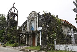
Typhoon Haiyan (Yolanda), one of the strongest typhoons ever recorded, made its first landfall in the coastal town of Guiuan in November 2013. [8]
Eastern Samar covers a total area of 4,660.47 square kilometers (1,799.42 sq mi) [9] occupying the eastern section and majority of southern Samar's coast of Samar Island in the Eastern Visayas region. The province is bordered to the north by Northern Samar and to the west by Samar. To the east lies the Philippine Sea, part of the vast Pacific Ocean, while to the south lies Leyte Gulf.
Because it faces the Philippine Sea of the Pacific Ocean, Eastern Samar suffers heavily from powerful typhoons. [4]
Eastern Samar comprises 22 municipalities and one city, all encompassed by an lone congressional district and two provincial districts that elect a representative and provincial board members, respectively.
Year | Pop. | ±% p.a. |
---|---|---|
1903 | 79,645 | — |
1918 | 117,348 | +2.62% |
1939 | 154,347 | +1.31% |
1948 | 197,734 | +2.79% |
1960 | 237,747 | +1.55% |
1970 | 271,000 | +1.32% |
1975 | 287,149 | +1.17% |
1980 | 320,637 | +2.23% |
1990 | 329,335 | +0.27% |
1995 | 362,324 | +1.80% |
2000 | 375,822 | +0.79% |
2007 | 405,114 | +1.04% |
2010 | 428,877 | +2.10% |
2015 | 467,160 | +1.64% |
2020 | 477,168 | +0.42% |
Source: Philippine Statistics Authority [10] [11] [11] |
The population of Eastern Samar in the 2020 census was 477,168 people, [2] with a density of 100 inhabitants per square kilometre or 260 inhabitants per square mile. The predominant language is Waray [6] and it is the main lingua franca of the entire island of Samar.[ citation needed ]
In the 2000 Census, Warays comprised 97.78% (366,787) of the total provincial population of 375,124 at that time. Kapampangan came second at 0.55% (2,067), Bisaya/Binisaya 0.43% (1,613), Cebuano at 0.18% (680), and Tagalog at 0.17% (621). [12]
The people of the province are devoted catholics where a majority adhere to Roman Catholicism. [6] The dominant Catholic faith influences the events of the provincial education, politics and social functions of the people.
Other Christians usually form the remaining groups of believers such as the Born-again Christians, Protestants, Iglesia Filipina Independiente or Aglipayan church, Jehovah's Witnesses, Iglesia ni Cristo, Baptists, Methodists, The Church of Jesus Christ of Latter-day Saints, and Seventh-day Adventists. Non Christians (mostly Muslims) are also found.
The province has one operational airport; Borongan Airport located in the capital city. Currently, only Leascor operates out of Borongan Airport with flights weekly to serve locals and tourists to and from Cebu.
By land, mini buses and vans ply from the regional center in Tacloban, Catbalogan, and Calbayog in Samar province and to some towns in Eastern Samar. From Borongan, buses ply to Metro Manila. Motorized boats plies through Leyte Gulf ferrying passengers going to Tacloban City seaport.
Commercial activities in the province are centered on the provincial capital of Borongan while tourism activities are centered in Guiuan town where Calicoan Island and the historical Homonhon Island are located. [6] Generally, the province's major economic resource is fishery and agriculture which include production of coconut, copra, corn, rice, sugar, and vegetables. [6] Tourism potential is untapped on the northern part of the province.
Leyte, officially the Province of Leyte, is a province in the Philippines located in the Eastern Visayas region occupying the northern three-quarters of Leyte Island. Its capital is the city of Tacloban, administered independently from the province. Leyte is thus north of Southern Leyte, south of Biliran, and west of Samar Island. To the west across the Camotes Sea is the province of Cebu.
Southern Leyte, officially the Province of Southern Leyte, is a province in the Philippines located in the Eastern Visayas region. Its capital is the city of Maasin. Southern Leyte comprised the third congressional district Leyte until it was made into an independent province in 1959. Southern Leyte includes Limasawa, an island to the south where the first Roman Catholic Mass in Philippine soil is believed to have taken place and thus considered to be the birthplace of Roman Catholicism in the Philippines.
Biliran, officially the Province of Biliran, is an island province in the Philippines located in the Eastern Visayas region. Biliran is one of the country's smallest and newest provinces. Formerly a sub-province of Leyte, it became an independent province in 1992.
Northern Samar, officially the Province of Northern Samar, is a province in the Philippines located in the Eastern Visayas region. Its capital is Catarman and is located at the northern portion of the island of Samar. Bordering the province to the south are the provinces of Samar and Eastern Samar. To the northwest, across the San Bernardino Strait is Sorsogon; to the east is the Philippine Sea of the Pacific Ocean and to the west is Samar Sea.
Samar, officially the Province of Samar, formerly named Western Samar, is a province in the Philippines located in the Eastern Visayas region. Its capital is the city of Catbalogan. It is bordered by Northern Samar, Eastern Samar, Leyte and Leyte Gulf, and includes several islands in the Samar Sea. Samar is connected to the island of Leyte via the San Juanico Bridge.
Davao Oriental, officially the Province of Davao Oriental, is a province in the Philippines located in the Davao Region in Mindanao. Its capital is the city of Mati, and it borders the province of Davao de Oro to the west, and Agusan del Sur and Surigao del Sur to the north. The province is the traditional homeland of the Mandaya and Kalagan/Kaagan.
Catarman, officially the Municipality of Catarman, is a 1st class municipality and capital of the province of Northern Samar, Philippines. According to the 2020 census, it has a population of 97,879 people. It is the commercial, educational, financial, and political center of the province and also its most populous municipality.
Cabucgayan, officially the Municipality of Cabucgayan, is a 5th class municipality in the province of Biliran, Philippines. According to the 2020 census, it has a population of 21,542 people. The town's populace predominantly speaks Waray.
Biliran, officially the Municipality of Biliran, is a 5th class municipality in the province of Biliran, Philippines. According to the 2020 census, it has a population of 17,662 people. The town's populace predominantly speaks Waray.
Matuguinao, officially the Municipality of Matuguinao, is a 5th class municipality in the province of Samar, Philippines. According to the 2020 census, it has a population of 7,364 people, making it the least populated municipality in the province.
San Vicente, officially the Municipality of San Vicente, is a 6th class municipality in the province of Northern Samar, Philippines.
Borongan, officially the City of Borongan, is a 1st class component city and capital of the province of Eastern Samar, Philippines. According to the 2020 census, it has a population of 71,961 people.
Guiuan, officially the Municipality of Guiuan, is a 2nd class municipality in the province of Eastern Samar, Philippines. It constitutes the southeastern extremity of Samar Island and some adjacent islands, surrounded by Leyte Gulf and the Philippine Sea, two major bodies of water that makes the town the surfing capital of the Visayas. According to the 2020 census, it has a population of 53,361 people, making it the most populous municipality in Eastern Samar and the second most populous administrative division in the entire province after the capital city Borongan.
Lawaan, officially the Municipality of Lawaan, is a 5th class municipality in the province of Eastern Samar, Philippines. According to the 2020 census, it has a population of 13,003 people. It is home to Bolusao Watershed Forest Reserve, primarily located in Barangay Bolusao.
Maydolong, officially the Municipality of Maydolong, is a 4th-class municipality in the province of Eastern Samar, Philippines. According to the 2020 census, it has a population of 15,314.
Mercedes, officially the Municipality of Mercedes, is a 5th class municipality in the province of Eastern Samar, Philippines. According to the 2020 census, it has a population of 6,112 people.
Salcedo, officially the Municipality of Salcedo, is a 5th class municipality in the province of Eastern Samar, Philippines. According to the 2020 census, it has a population of 22,136 people.
San Isidro, officially the Municipality of San Isidro, is a 4th class municipality in the province of Leyte, Philippines. According to the 2020 census, it has a population of 30,722 people.
Catbalogan, officially the City of Catbalogan, is a 5th class component city and capital city of the province of Samar, Philippines. According to the 2020 census, it has a population of 106,440 people.
Eastern Visayas is an administrative region in the Philippines, designated as Region VIII. It consists of three main islands, Samar, Leyte and Biliran. The region has six provinces, one independent city and one highly urbanized city namely, Biliran, Leyte, Northern Samar, Samar, Eastern Samar, Southern Leyte, Ormoc and Tacloban. The highly urbanized city of Tacloban is the sole regional center. These provinces and cities occupy the easternmost islands of the Visayas group of islands.