
Owing to its numerous islands, the Philippines has an irregular coastline stretching 334,539 kilometers (207,873 miles). The islands' rugged coastlines provide several bays and inlets listed below. FYI, Laguna de Bay is not a bay, but a lake.
Owing to its numerous islands, the Philippines has an irregular coastline stretching 334,539 kilometers (207,873 miles). The islands' rugged coastlines provide several bays and inlets listed below. FYI, Laguna de Bay is not a bay, but a lake.

Geography of the Philippines | ||
|---|---|---|
| Geology |  | |
| Landforms | ||
| Water | ||
| Seas | ||
| Environment | ||
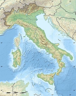
The geography of Italy includes the description of all the physical geographical elements of Italy. Italy, whose territory largely coincides with the homonymous geographical region, is located in southern Europe and comprises the long, boot-shaped Italian Peninsula crossed by the Apennines, the southern side of Alps, the large plain of the Po Valley and some islands including Sicily and Sardinia. Italy is part of the Northern Hemisphere. Two of the Pelagie Islands are located on the African continent.

The Philippines is an archipelago that comprises 7,641 islands, and with a total land area of 300,000 square kilometers (115,831 sq mi), it is the world's fifth largest island country. The eleven largest islands contain 95% of the total land area. The largest of these islands is Luzon at about 105,000 square kilometers (40,541 sq mi). The next largest island is Mindanao at about 95,000 square kilometers (36,680 sq mi). The archipelago is around 800 kilometers (500 mi) from the Asian mainland and is located between Taiwan and Borneo.

The geography of Malta is dominated by water. Malta is an archipelago of coralline limestone, located in Europe, in the Mediterranean Sea, 81 kilometres south of Sicily, Italy, and nearly 300 km north (Libya) and northeast (Tunisia) of Africa. Although Malta is situated in Southern Europe, it is located farther south than Tunis, capital of Tunisia, Algiers, capital of Algeria, Tangier in Morocco and also Aleppo in Syria, and Mosul in Iraq in the Middle East. Only the three largest islands – Malta, Gozo and Comino – are inhabited. Other (uninhabited) islands are: Cominotto, Filfla and the St.Paul's Islands. The country is approximately 316 km2 (122 sq mi) in area. Numerous bays along the indented coastline of the islands provide harbours. The landscape of the islands is characterised by high hills with terraced fields. The highest point, at 253 metres, Ta' Zuta on mainland Malta. The capital is Valletta.

Victoria Island is a large island in the Arctic Archipelago that straddles the boundary between Nunavut and the Northwest Territories of Canada. It is the eighth-largest island in the world, and at 217,291 km2 (83,897 sq mi)1 in area, it is Canada's second-largest island. It is nearly double the size of Newfoundland (111,390 km2 [43,010 sq mi]), and is slightly larger than the island of Great Britain (209,331 km2 [80,823 sq mi]) but smaller than Honshu (225,800 km2 [87,200 sq mi]). The western third of the island lies in the Inuvik Region of the Northwest Territories; the remainder is part of Nunavut's Kitikmeot Region. The population of 2,168 is divided between two settlements, the larger of which is Cambridge Bay (Nunavut) and the other Ulukhaktok.

The Gulf of St. Lawrence fringes the shores of the provinces of Quebec, New Brunswick, Nova Scotia, Prince Edward Island, Newfoundland and Labrador, in Canada, plus the islands Saint-Pierre and Miquelon, possessions of France, in North America.
Northern Samar, officially the Province of Northern Samar, is a province in the Philippines located in the Eastern Visayas region. Its capital is Catarman, the most populous town in the province and is located at the northern portion of the island of Samar. Bordering the province to the south are the provinces of Samar and Eastern Samar. To the northwest, across the San Bernardino Strait is Sorsogon; to the east is the Philippine Sea of the Pacific Ocean and to the west is Samar Sea.

Sarangani, officially the Province of Sarangani, is a province in the Philippines located in the Soccsksargen region. Its capital is Alabel while Glan is the most populous municipality in the province. With a 230-kilometer (140 mi) coastline along the Sarangani Bay and Celebes Sea, the province is at the southernmost tip of Mindanao island, and borders South Cotabato and Davao del Sur to the north, Davao Occidental to the east, and the Celebes Sea to the south.

The Strait of Georgia or the Georgia Strait is an arm of the Salish Sea between Vancouver Island and the extreme southwestern mainland coast of British Columbia, Canada, and the extreme northwestern mainland coast of Washington, United States. It is approximately 240 kilometres (150 mi) long and varies in width from 20 to 58 kilometres. Along with the Strait of Juan de Fuca and Puget Sound, it is a constituent part of the Salish Sea.

The Labrador Sea is an arm of the North Atlantic Ocean between the Labrador Peninsula and Greenland. The sea is flanked by continental shelves to the southwest, northwest, and northeast. It connects to the north with Baffin Bay through the Davis Strait. It is a marginal sea of the Atlantic.

Lemaire Channel is a strait off Antarctica, between Kyiv Peninsula in the mainland's Graham Land and Booth Island. Nicknamed "Kodak Gap" by some, it is one of the top tourist destinations in Antarctica; steep cliffs hem in the iceberg-filled passage, which is 11 km (6.8 mi) long and just 600 metres (2,000 ft) wide at its narrowest point.

Dinagat Islands, officially the Province of Dinagat Islands, is an island province in the Caraga region of the Philippines, located on the south side of Leyte Gulf. The island of Leyte is to its west, across Surigao Strait, and mainland Mindanao is to its south. Its main island, Dinagat, is about 60 kilometres (37 mi) from north to south. San Jose serves as its provincial capital while Basilisa is the most populous town in the province.
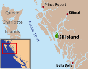
Gil Island is an island on the North Coast of British Columbia, Canada, located on the west side of Whale Channel in the entrance to Douglas Channel, one of the main coastal inlets, on the route of the Inside Passage between Pitt Island and Princess Royal Island. It is 26 km (16 mi) long, with a width ranging from 6 to 13 km, and an area of 231 km2. The only named summit on the mountainous island is Mount Gil, which faces the opening of Douglas Channel.

The Vancouver Island Ranges, formerly called the Vancouver Island Mountains, are a series of mountain ranges extending along the length of Vancouver Island which has an area of 31,788 km2 (12,273 sq mi). The Vancouver Island Ranges comprise the central and largest part of the island. The Geological Survey of Canada refers to Vancouver Island, Haida Gwaii, and the Alaska Panhandle as the Insular Belt including the sea floor out to 100 km (62 mi) west of Vancouver Island. The Vancouver Island Ranges are a sub-range of the Insular Mountains.

Soquel Canyon State Marine Conservation Area (SMCA) is an offshore marine protected area in Monterey Bay. Monterey Bay is on California’s central coast with the city of Monterey at its south end and the city of Santa Cruz at its north end. The SMCA covers 23.41 square miles (60.6 km2). Within the SMCA, fishing and taking of any living marine resources is prohibited except the commercial and recreational take of pelagic finfish.