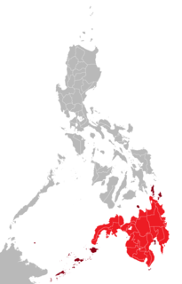
Mindanao, also commonly known as Southern Philippines, is the second-largest island in the Philippines. Mindanao and the smaller islands surrounding it make up the island group of the same name. Located in the southern region of the archipelago, as of the 2010 census, the main island was inhabited by 20,281,545 people, while the entire Mindanao island group had an estimated population of 25,537,691 (2018).

Zamboanga is a former province of the Philippines located in the western region of the southern island of Mindanao, Philippines.

Zamboanga del Sur is a province in the Philippines located in the Zamboanga Peninsula region in Mindanao. Its capital is the city of Pagadian. Statistically grouped with Zamboanga del Sur is the highly urbanized city of Zamboanga, which is geographically separated and a chartered city and governed independently from the province.

Zamboanga Peninsula is an administrative region in the Philippines, designated as Region IX. The region consists of three provinces and two cities. The region was previously known as Western Mindanao before the enactment of Executive Order No. 36 on August 12, 2015. The city of Zamboanga was designated as the regional center until Pagadian City was designated as its new regional center, although Zamboanga City remains the region's cultural, economic, and educational center.

Zamboanga Sibugay is a province in the Philippines located in the Zamboanga Peninsula region in Mindanao. Its capital is Ipil and it borders Zamboanga del Norte to the north, Zamboanga del Sur to the east and Zamboanga City to the southwest. To the south lies Sibuguey Bay in the Moro Gulf.

Buug, officially the Municipality of Buug, is a 3rd class municipality in the province of Zamboanga Sibugay, Philippines. According to the 2015 census, it has a population of 36,634 people.
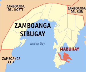
Mabuhay, officially the Municipality of Mabuhay, is a 4th class municipality in the province of Zamboanga Sibugay, Philippines. According to the 2015 census, it has a population of 36,870 people.
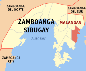
Malangas, officially the Municipality of Malangas,, is a 3rd class municipality in the province of Zamboanga Sibugay, Philippines. According to the 2015 census, it has a population of 33,380 people.

Olutanga, officially the Municipality of Olutanga, is a 4th class municipality in the province of Zamboanga Sibugay, Philippines. According to the 2015 census, it has a population of 33,671 people.

Talusan, officially the Municipality of Talusan, is a 5th class municipality in the province of Zamboanga Sibugay, Philippines. According to the 2015 census, it has a population of 29,969 people.

Titay, officially the Municipality of Titay, is a 2nd class municipality in the province of Zamboanga Sibugay, Philippines. According to the 2015 census, it has a population of 49,673 people.

Lapuyan is a third class municipality in the province of Zamboanga del Sur, Philippines. According to the 2015 census, it has a population of 27,264 people. The municipality of Lapuyan is located in the southern section of the Zamboanga del Sur province. It is also often referred to as "Little America".

Bayog, officially the Municipality of Bayog, is a 3rd class municipality in the province of Zamboanga del Sur, Philippines. According to the 2015 census, it has a population of 33,591 people.
Margosatubig, officially the Municipality of Margosatubig, is a 3rd class municipality in the province of Zamboanga del Sur, Philippines. According to the 2015 census, it has a population of 37,873 people.

Vincenzo A. Sagun, officially the Municipality of Vincenzo A. Sagun, is a 5th class municipality in the province of Zamboanga del Sur, Philippines. According to the 2015 census, it has a population of 23,759 people.
The Legislative Districts of Zamboanga Sibugay are the representations of the province of Zamboanga Sibugay in the Congress of the Philippines. The province is currently represented in the lower house of the Congress through its first and second congressional districts.
The Legislative Districts of Zamboanga del Sur are the representations of the province of Zamboanga del Sur in the various national legislatures of the Philippines. The province is currently represented in the lower house of the Congress of the Philippines through its first and second congressional districts.
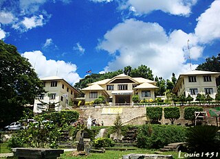
The J.H. Cerilles State College is a public college in the Philippines. Its main campus is located in Mati, San Miguel, Zamboanga del Sur.

The Mount Timolan Protected Landscape is a protected area covering Mount Timolan and its surrounding forested landscape in the region of Zamboanga Peninsula on Mindanao in the Philippines. The park encompasses an area of 1,994.79 hectares and a buffer zone of 695.39 hectares in the municipalities of San Miguel, Guipos and Tigbao in the province of Zamboanga del Sur. It was established on 14 August 2000 through Proclamation Order No. 354 issued by President Joseph Estrada. The park was also earlier established by the provincial government of Zamboanga del Sur as a provincial park and wildlife sanctuary known as the Zamboanga del Sur Provincial Park through Provincial Ordinance No. 3 in 1992.

The Sama language, Sinama, is the language of Sama-Bajau people of the Sulu Archipelago, Philippines; Sabah, Malaysia and parts of Indonesia. The Sama are one of the most widely dispersed peoples in Southeast Asia.


