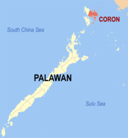
Coron, officially the Municipality of Coron (Tagalog: Bayan ng Coron), is a municipality in the province of Palawan, Philippines. According to the 2024 census, it has a population of 69,439 people.[5]
Before the present name, it was called Bancuang, named after the native name of the palm that grew abundantly along the rivers and marshes especially at the spot where the spring that was source of the town's water supply was found. When the Spaniards arrived, they named the area Peñon de Coron, after the Tagbanua word "Corong", a type of pot. In 1902, the name was changed into Coron, its present name.[7]
History
Precolonial and Spanish era
The Calamian Islands were originally inhabited mainly by Tagbanuas and the Calamianen beginning their settlement in the 11th century.[7][8] Oral history tells that the Datu Macanas ruled the entire Busuanga Island where present-day Coron town lies. Early on Spanish exploration of the islands, Fray de la Concepcion took note of the friendliness of the people of Busuanga Island and the ferocity of the Tagbanua tribe living in Coron Island.[7]
Early on the history of the Calamianes, Coron was directly ruled by the Spanish in Mindoro while the island of Cuyo by the Spanish authorities in Panay. In this area of the Calamianes, the first permanent Spanish settlement was Culion, with Coron as its visita.[7] A fort and church were built in Libis (San Pedro), Culion around 1670 by the Spaniards as part of the defenses against the Muslim raids.
Between 1730-1735, Spanish missionaries built another cotta at Culion to defend from Moro incursions. The Spaniards eventually left for Panay with the exception of priests who stayed at Camianan.[7]
Coron became a settlement for migrants to the Calamianes. Don Nicolas Manlavi, a Cuyonon served several years in Spanish Galleons, and an Ilonggo from Jaro, Ilo-ilo named Claudio Sandoval later wed Nicolas' only daughter Evarista. The Sandoval clan of the Calamianes came from this union.
It was Don Nicolas Manlavi who established the first settlement in Coron in 1749 which was initially at Banuang Lague (old town) in present-day Banuang Daan in Coron Island. Due to Moro depredations, many people moved to Tagum and Makinit, living in these areas temporarily. In 1800, a new town site was created and people began resettling into this place. To defend from the Moro attacks, they built the Coron Fortress and the Ili Fort in San Miguel at Linacapan.[7]
Revolutionary era
After the outbreak of the Philippine Revolution led by the Katipunan, the Spaniards became paranoid and convicted 200 men in both Balabac and Calamianes of being anti-Spanish propagandists and placed them in exile. At least half of them were from Busuanga. The anti-Spanish propagandists garrisoned in Culion were led by Rufo Sandoval.[7]
In January 1899, in the aftermath of the revolution, an expedition by revolutionary general Esteban Causapin, Capitan Kilatan and Commandant Pascual Silva with about 20 soldiers arrived at Coron. They told the people that their purpose was to liberate them from the Spaniards of the Hacienda Malbate owned by Bernardo Ascano. The people were easily won over and many recruits were acquired. As a result, Bernardo Ascano and his family were imprisoned by the revolutionaries. Commandant Silva remained at Malbate and confiscated the property of a rich Chinese man named Laurente Tan.[7]
Overtime, the principales of Cuyo heard of the unlawful activities of Silva and sought the aid of the Capitan General of Iloilo. The Capitan General then sent Commandant Simeon Rodriguez and his son Captain Gregorio Rodriguez to Cuyo. The tercio civiles under Lieutenant Federico Quizon were turned over to these authorities. Gregorio remained in Cuyo while Simeon and Quizon arrived in Culion in February of the same year. Quizon made an attempt to collaborate with Silva but was caught and executed by Simeon's forces. Silva then left Malbate and proceeded to Bintuan to get more rice. He went to Juan Palanca, a rich Chinese man from the area. Palanca delayed giving help to Silva and secretly informed the authorities of Silva's presence in the area. Silva was eventually arrested, taken to Culion and executed. From this point forward, the people of Coron were able to live peacefully.[7]
American era
In 1899, American forces arrived in the area and established a military government.[7]
Late in the 1890s, an American naturalist, Dean Worcester, journeyed through the Calamianes collecting specimens and stayed briefly in Culion. At the turn of the century, he was appointed part of the First Philippine Commission, becoming the Secretary of the Interior. He recommended Culion as the Philippine Leper Colony. This act forced the transfer of the Sandoval clan in 1900 to the various barrios of what is now Coron and Busuanga. The Coron town was settled by the family of Claudio Sandoval, and the other Sandovals settled in what is now Bintuan, Salvacion, Concepcion, and Old Busuanga.[7]
On June 2, 1902, a civil government was established with Don Vicente Sandoval as the first Municipal President of Coron thereby converting Coron into a municipality. Since 1905, lepers were segregated in Culion.[7]
In 1907, a beautiful church was built at San Miguel by Capitan Gabino Perez, which remains in total ruin after World War II. However, its old foundation remains visible.[7]
In 1937, during the tenure of Mayor Francisco Reyes, mining companies began operating in the municipality in search of manganese, especially at Malbate. The Compania Minera de Filipina were the first of these exploitative companies. On October 17, 1937, Mayor Francisco Reyes and 6 other councilors resigned due to resentment. He was succeeded by Pedro S. Echague.[7]
World War II
Japanese occupation
At 0800 on May 4, 1942, the Imperial Japanese Army arrived in Coron without facing any resistance as its Acting Mayor Quitin Garraez surrendered immediately. Francisco Reyes was made mayor again and he became responsible for saving many lives during his tenure as a puppet mayor. In July of the same year, the Japanese occupied the mining camps. During the Japanese occupation, Filipinos were subjected to the brutality of the Kempeitai through tortures, plunder, rape and all other kinds of atrocities.[7]
Filipino resistance
During this point, guerrilla activities intensified. On September 2, Captain Bajar with 18 Americans captured and killed 2 Japanese soldiers at Patungan. The Japanese retaliated on the 5th by massacring the people of Patungan. On the 7th, guerrilla forces launched a counterattack under Captain Carlos Amores at Singay Camp. They attacked on the 8th and the 9th where they attacked Japanese launches and massacred their forces. Another encounter occurred on the 29th between the Japanese and Filipino forces under Lt. Jesus Rañada and Lt. Simeon Macolor. By December 1942, guerrilla supplies at Coron were exhausted.[7]
On February 26, 1943, guerrilla forces landed at Sitio Colatang and organized their headquarters at Otoy and Cobata.[7]
On September 24,1944, at around 0900, more than 100 American planes arrived in the skies of Coron and bombed up to 24-80 Japanese ships of different categories. Most of them were sunk at Busuanga.[7][9][10]
Liberation
In February 1945, guerrillas from Palawan arrived at Culion and established their headquarters. American planes came and brought food for the lepers and civilian refugees. American P.T. boats went to Coron and subjected the town to bombardments. Lt. Trinidad Vizconde led the attack. It was believed that the Japanese were still at Coron and were waiting for the arrival of the American liberation forces. Many houses were burned as a result of this attack. By March, Coron was liberated from Japanese control. American forces then used an airfield in Malaking Patag. As a result of his wartime merits, Captain Carlos Amores eventually became the mayor of Coron.[7]
Post-war independence
In 1950, the town of Busuanga was created from the barrios of Concepcion, Salvacion, Busuanga, New Busuanga, Buluang, Quezon, Calawit, and Cheey which used to belong to Coron.[11] In 1954, the islands of Linapacan, Cabunlaoan, Niangalao, Decabayotot, Calibanbangan, Pical, and Barangonan were separated from Coron to form the town of Linapacan.[12]
On June 5, 1998, Coron Island was recognized as an ancestral domain with the issuance of CADC No. 134 to the Tagbanua people.[13]
Geography
The municipality of Busuanga comprises the western part of Busuanga Island, while Coron comprises the eastern part of Busuanga Island, all of Coron Island and about 50 other minor islets stretching as far as Tara Island in the north-east and Canipo Island in the south.[14] All these islands are part of the Calamian Archipelago in northern Palawan that separates the South China Sea from the Sulu Sea.
Barangays
Coron is politically subdivided into 23 barangays. Each barangay consists of puroks and some have sitios.
In the 2024 census, the population of Coron was 69,439 people,[22] with a density of 100 inhabitants per square kilometre or 260 inhabitants per square mile.
The main industries of Coron are fishing and tourism.[citation needed] Former industries include manganese mining at Singay Mines in Barangay San Nicolas during the Japanese Occupation period. This was followed by the fishing industry boom during the 1970s up to the 1990s which gradually dwindled due to illegal blast and sodium cyanide fishing. The rattan and basket-weaving industry which also gradually declined during the same period due to the ensuing depletion of raw materials.
Currently tourism is the top industry in Coron due to local beaches, dive sites, Lagoons and other natural tourist spots.[31] A dozen sunken Japanese warships at depths between 10 and 40 meters (33 and 131ft) off Coron Island is a diving destination,[14] listed in Forbes Traveler Magazine’s top 10 best scuba diving sites in the world.[citation needed] A description of the diving highlights in 2021 is provided by Dive the World.[32]
The municipality is the commercial capital of the Calamian Islands.
The main population center of the municipality is composed of Poblacionbarangays 1 to 6, where the Municipal Building, the Municipal Legislative Building, and the Judicial Hall of the Municipal Circuit Trial Court are located.
Town fiesta is held annually on August 28 in honor of Saint Augustine.
Education
There are two schools district offices which govern all educational institutions within the municipality. They oversee the management and operations of all private and public, from primary to secondary schools.[35] These are the:
Coron Coastal Schools District
Coron Inland Schools District
Primary and elementary schools
Banuang Daan Elementary School
Bayang Elementary School
Bayo Bayo Elementary School
Benecan Elementary School
Bintuan Elementary School
Borac Elementary School
Buenavista Elementary School
Buyot Elementary School
Cabugao Elementary School
Camanga Elementary School
Canipo Elementary School
Capayas Elementary School
Central Fundamental Baptist Church of Coron Learning Center
This page is based on this Wikipedia article Text is available under the CC BY-SA 4.0 license; additional terms may apply. Images, videos and audio are available under their respective licenses.