Mimaropa

Last updated

Mimaropa
Southwestern Tagalog Region
Big lagoon entrance, Miniloc island - panoramio.jpg
Island home.jpg
Guiting-guiting 1.jpg
Boac cathedral, Marinduque.jpg
Tamaraw Falls, Mindoro, Philippines.jpg
Clockwise from the top: El Nido, Palawan, Mount Guiting-Guiting, Tamaraw Falls, Boac Cathedral, Coron Island
MIMAROPA in Philippines.svg
Location in the Philippines
OpenStreetMap
Mimaropa
Coordinates: 10°40′N119°30′E / 10.67°N 119.5°E / 10.67; 119.5
CountryFlag of the Philippines.svg  Philippines
Island group Luzon
Regional center Calapan (Oriental Mindoro)
Largest city Puerto Princesa
Area
  Total29,620.90 km2 (11,436.69 sq mi)
Highest elevation2,586 m (8,484 ft)
Population
 (2020 census) [1]
  Total3,228,558
  Density110/km2 (280/sq mi)
Time zone UTC+8 (PST)
ISO 3166 code PH-41
Provinces
Cities
Municipalities 71
Barangays 1,460
Cong. districts 7
Languages
GDP (2021) 382 billion
$7 billion [2]
Growth rateIncrease2.svg (3.3%) [2]
HDI Increase2.svg 0.673 (Medium)
HDI rank 15th in the Philippines (2019)

Mimaropa (officially stylized in all caps), officially the Southwestern Tagalog Region [3] [4] (Filipino : Rehiyong Timog-Kanlurang Tagalog), is an administrative region in the Philippines. It is one of two regions in the country having no land border with another region (the other being Eastern Visayas). The name is an acronym combination of its constituent provinces: Mindoro (divided into Occidental Mindoro and Oriental Mindoro), Marinduque, Romblon and Palawan.

Contents

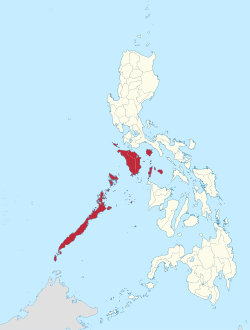
The region was part of the now-defunct Southern Tagalog region until May 17, 2002. [5] On May 23, 2005, Palawan and the highly urbanized city of Puerto Princesa were moved to the region of Western Visayas by Executive Order No. 429. [6] However, on August 19, 2005, President Arroyo issued Administrative Order No. 129 to put in abeyance Executive Order No. 429 pending a review. [7] On July 17, 2016, Republic Act No. 10879 formally established the Southwestern Tagalog Region to be known as Mimaropa, discontinuing the Region IV-B designation; however, no boundary changes were involved. [3]

Calapan is Mimaropa's regional center. [8] However, most regional government offices such as the Department of Public Works and Highways [9] and the Department of Budget and Management are in Quezon City, Metro Manila.

History

Mimaropa, together with Calabarzon, were officially created with the partitioning of Southern Tagalog (Region IV) into the two regions on May 17, 2002, with the issuance of Executive Order No. 103 by then-President Gloria Macapagal Arroyo; for the purpose of promoting efficiency in the government, accelerating social and economic development and improving public services in the provinces covered. Region IV-B was designated as Mimaropa, which stands for the island provinces belonging to the Southern Tagalog region—Mindoro (Oriental and Occidental), Marinduque, Romblon and Palawan. Region IV-A was designated as Calabarzon. [5] Marinduque was a sub-province of Quezon, at that time known as Tayabas; it became independent province in 1920. Quezon is now part of Calabarzon. Romblon was a sub-province of Capiz & was part of Western Visayas. When President Ferdinand Marcos enacted Presidential Decree No. 1, which organized the provinces into 11 regions as part of Marcos' Integrated Reorganization Plan, [10] Romblon was transferred from Western Visayas to Southern Tagalog.

On May 23, 2005, Executive Order 429 was issued, moving the province of Palawan to the region of Western Visayas, [6] designating Region IV-B as "Mimaro". However, Palawan residents criticized the move, citing a lack of consultation, with most residents in Puerto Princesa and nearly all municipalities preferring to stay with Region IV-B. Consequently, Administrative Order No. 129 was issued on August 19, 2005, to address this backlash. This order directed the abeyance of Executive Order 429 pending the approval of an implementation plan for the orderly transfer of Palawan from Mimaropa to Region VI. [7]

The 2010 Philippine Census of Population reported the region's name as "Mimaropa" and included Palawan as part of the region. [11] As of 2014, it is not clear whether the transfer of Palawan to Western Visayas is still considered pending by the Philippine government. As of 2014, the National Statistical Coordinating Board of the Philippines continued to list Palawan province as part of the Mimaropa region. [12] [ needs update ]

On July 17, 2016, Republic Act No. 10879 formally established the Southwestern Tagalog Region to be known as the Mimaropa Region. This involved no boundary changes but was in effect merely a renaming and discontinuation of the "Region IV-B" designation. [3]

Demographics

Population census of Mimaropa
YearPop.±% p.a.
1903 179,800    
1918 262,462+2.55%
1939 406,377+2.10%
1948 468,619+1.60%
1960 722,227+3.67%
1970 1,020,222+3.51%
1975 1,219,609+3.64%
1980 1,408,040+2.91%
1990 1,774,074+2.34%
1995 2,033,271+2.59%
2000 2,299,229+2.67%
2007 2,559,791+1.49%
2010 2,744,671+2.57%
2015 2,963,360+1.47%
2020 3,228,558+1.70%
Source: Philippine Statistics Authority [1] [13]

Languages

A view of Calapan as seen in December 2009 JP-Rizal-Avenue-Calapan City.jpg
A view of Calapan as seen in December 2009

The native languages of Mimaropa are:

Economy

In 2007, Mimaropa's economy surged by 9.4%, making it the fastest growing region in the country in that year. [20] It was aided by robust growth in the industrial sector which grew by 19.1% from -6.1% in 2006. [20] Mimaropa experienced a big slowdown in 2006, posting a decelerated growth of 2.3% from a 6.4% increase in 2005. This resulted mainly from the slump in the industry sector, which shrunk by 5.4% in 2006 from its 10.8% increase in 2005.

The agriculture, forestry, and fishing sector, which contributed 42.1% to the total regional economy, grew by 9.1% in 2006, accelerating from 3.2% the previous year. The higher production of rice, maize, other crops, livestock and fishery resulted in the accelerated growth in the total agriculture and fishery sector.

The industry sector, which contributed 38.3% to the region's total economy, was the second largest contributor next to agriculture. Its decline of 5.4% was largely attributed to the decrease in the mining and quarrying sub-sector, which went down by 15.4% due to the reduced production of natural gas in Palawan. Mining and quarrying contributed 16.6% to the total regional economy. The positive growth in the electricity and water, construction and manufacturing sub-sectors were not able to compensate to the drop in the mining and quarrying sub-sector.

The service sector, on the other hand, posted an accelerated growth of 5.1%, which was attributed to the increase in the TCS, finance, private services, government services and trade sub-sectors, which managed to post accelerated growths of 6.0%, 5.5%, 5.1%, 5.1% and 4.7%, respectively. The other sub-sector, however, had a decelerated growth due to the slowdown in the ownership of dwelling.

Tourism

There are many scenic spots in Mimaropa. Some of them are the Bathala Cave, Balanacan Bay, and Tres Reyes Islands in the province of Marinduque; White Island in Mindoro; Fort San Andres, Mount Guiting-Guiting, and Bonbon Beach in Romblon; and the Puerto Princesa Subterranean River National Park and El Nido Marine Reserve Park in Palawan.

Administrative divisions

Provinces

Political map of Mimaropa Ph MIMAROPA.png
Political map of Mimaropa

Mimaropa comprises 5 provinces, 1 highly urbanized city (Puerto Princesa), 1 component city (Calapan), 71 municipalities and 1,460 barangays.

  •   Regional center
Province orHUCCapitalPopulation (2020) [21] AreaDensityCitiesMuni.Barangay
km2sq mi/km2/sq mi
Marinduque Boac 7.4%239,207952.58367.7925065006218
Occidental Mindoro Mamburao 16.3%525,3545,865.702,264.7690230011164
Oriental Mindoro Calapan 28.1%908,3394,238.401,636.46210540114426
Palawan Puerto Princesa 29.1%939,59414,649.705,656.2864170023367
Romblon Romblon 9.6%308,9851,533.50592.09200520017219
Puerto Princesa 9.5%307,0792,381.02919.3213034066
Total3,228,55829,620.9011,436.691102802711,460

   Puerto Princesa is a highly urbanized city pursuant to Presidential Proclamation No. 1264; [22] figures are excluded from Palawan.

Governors and vice governors

ProvinceImageGovernorPolitical PartyVice Governor
Gov Velasco.png Presbitero J. Velasco, Jr. PDP–Laban Adeline Angeles
Province of Occidental Mindoro seal.svg
Gov Gadiano.png Eduardo Gadiano PFP Anecita Diana Apigo-Tayag
Ph seal Oriental Mindoro.png
Gov Dolor.png Humerlito Dolor PDP–Laban Ejay Falcon
PGP New Official Seal.png
Gov Socrates.png Victorino Dennis M. Socrates PPPL Leoncio Nacasi Ola
Ph seal romblon.png
Gov Riano.png Jose Riano PDP–Laban Armando Gutierrez

Related Research Articles

<span class="mw-page-title-main">Visayas</span> Archipelago in the Philippines

The Visayas, or the Visayan Islands, are one of the three principal geographical divisions of the Philippines, along with Luzon and Mindanao. Located in the central part of the archipelago, it consists of several islands, primarily surrounding the Visayan Sea, although the Visayas are also considered the northeast extremity of the entire Sulu Sea. Its inhabitants are predominantly the Visayan peoples.

<span class="mw-page-title-main">Calabarzon</span> Administrative region of the Philippines

Calabarzon, sometimes referred to as Southern Tagalog and designated as Region IV‑A, is an administrative region in the Philippines. The region comprises five provinces: Batangas, Cavite, Laguna, Quezon, and Rizal; and one highly urbanized city, Lucena. It is the most populous region in the Philippines according to the Philippine Statistics Authority (PSA), having over 16.1 million inhabitants in 2020, and is also the country's second most densely populated after the National Capital Region. It is situated southeast of Metro Manila, and is bordered by Manila Bay and South China Sea to the west, Lamon Bay and the Bicol Region to the east, Tayabas Bay and the Sibuyan Sea to the south, and Central Luzon to the north. It is home to places like Mount Makiling near Los Baños, Laguna, and Taal Volcano in Batangas.

<span class="mw-page-title-main">Palawan</span> Province in Mimaropa, Philippines

Palawan, officially the Province of Palawan, is an archipelagic province of the Philippines that is located in the region of Mimaropa. It is the largest province in the country in terms of total area of 14,649.73 km2 (5,656.29 sq mi). The capital and largest city is Puerto Princesa wherein it is geographically grouped but administered independently from the province. Palawan is known as the Philippines' Last Frontier and as the Philippines' Best Island.

<span class="mw-page-title-main">Romblon</span> Province in Mimaropa, Philippines

Romblon, officially the Province of Romblon, is an archipelagic province of the Philippines located in the Mimaropa region. Its main components include Romblon, Romblon, an archipelagic municipality of the same name that also serves as the provincial capital; Tablas, the largest island, covering nine municipalities; Sibuyan with its three towns; as well as the smaller island municipalities of Corcuera, Banton, Concepcion, San Jose. The province lies south of Marinduque and Quezon, east of Oriental Mindoro, north of Aklan and Capiz, and west of Masbate. According to the 2020 census, it has a total population of 308,985.

<span class="mw-page-title-main">Marinduque</span> Province in Mimaropa, Philippines

Marinduque, officially the Province of Marinduque, is an island province in the Philippines located in Southwestern Tagalog Region or Mimaropa, formerly designated as Region IV-B. Its capital is the municipality of Boac. Marinduque lies between Tayabas Bay to the north and Sibuyan Sea to the south. It is west of the Bondoc Peninsula of Quezon province in mainland Luzon; east of Mindoro Island; and north of the island province of Romblon. Some parts of the Verde Island Passage, the center of the center of world's marine biodiversity and a protected marine area, are also within Marinduque's provincial waters.

<span class="mw-page-title-main">Oriental Mindoro</span> Province in Mimaropa, Philippines

Oriental Mindoro, officially the Province of Oriental Mindoro, is a province in the Philippines located on the island of Mindoro under Mimaropa region in Luzon, about 140 kilometres (87 mi) southwest of Manila. The province is bordered by the Verde Island Passage and the rest of Batangas to the north, by Marinduque, Maestre de Campo Island, Tablas Strait and the rest of Romblon to the east, by Semirara and the rest of Caluya Islands, Antique to the south, and by Occidental Mindoro to the west. Calapan, the only city in the island, is the provincial capital and Mimaropa's regional center.

<span class="mw-page-title-main">Southern Tagalog</span> Former administrative region of the Philippines

Southern Tagalog, designated as Region IV, was an administrative region in the Philippines that comprised the current regions of Calabarzon and Mimaropa, the province of Aurora of Central Luzon, and several cities of Metro Manila. The name remains as a cultural-geographical region only, which exempts Aurora.

<span class="mw-page-title-main">Western Visayas</span> Administrative region of the Philippines

Western Visayas is an administrative region in the Philippines, numerically designated as Region VI. It consists of six provinces and two highly urbanized cities. The regional center is Iloilo City. The region is dominated by the native speakers of four Visayan languages: Hiligaynon, Kinaray-a, Aklanon and Capiznon. The land area of the region is 20,794.18 km2 (8,028.68 sq mi), and with a population of 7,954,723 inhabitants, it is the second most populous region in the Visayas after Central Visayas.

<span class="mw-page-title-main">Aborlan</span> Municipality in Palawan, Philippines

Aborlan, officially the Municipality of Aborlan, is a 1st class municipality in the province of Palawan, Philippines. According to the 2020 census, it has a population of 38,736 people.

<span class="mw-page-title-main">Brooke's Point</span> Municipality in Palawan, Philippines

Brooke's Point, officially the Municipality of Brooke's Point, is a 1st class municipality in the province of Palawan, Philippines. According to the 2020 census, it has a population of 73,994 people.

<span class="mw-page-title-main">Concepcion, Romblon</span> Municipality in Romblon, Philippines

Concepcion, officially the Municipality of Concepcion, is a 6th class municipality in the province of Romblon, Philippines. The municipality is coextensive with Maestre de Campo Island, which is also known as Sibale Island. According to the 2020 census, it has a population of 3,561 people.

<span class="mw-page-title-main">Ferrol, Romblon</span> Municipality in Romblon, Philippines

Ferrol, officially the Municipality of Ferrol, is a 6th class municipality in the province of Romblon, Philippines. According to the 2020 census, it has a population of 8,005 people.

<span class="mw-page-title-main">Puerto Princesa</span> Capital and largest highly urbanized city of Palawan, Philippines

Puerto Princesa, officially the City of Puerto Princesa, is a 1st class highly urbanized city in the Mimaropa region of the Philippines. According to the 2020 census, it has a population of 307,079 people.

<span class="mw-page-title-main">Narra, Palawan</span> Municipality in Palawan, Philippines

Narra, officially the Municipality of Narra, is a 1st class municipality in the province of Palawan, Philippines. According to the 2020 census, it has a population of 77,948 people.

<span class="mw-page-title-main">Quezon, Palawan</span> Municipality in Palawan, Philippines

Quezon, named by the late President Manuel L. Quezon and officially named the Municipality of Quezon, is a first-class municipality in the province of Palawan, Philippines. According to the 2020 census, it has a population of 65,283 people.

<span class="mw-page-title-main">Rizal, Palawan</span> Municipality in Palawan, Philippines

Rizal, officially the Municipality of Jose P. Rizal,, is a 1st class municipality in the province of Palawan, Philippines. According to the 2020 census, it has a population of 56,162 people.

<span class="mw-page-title-main">Roxas, Palawan</span> Municipality in Palawan, Philippines

Roxas, officially the Municipality of Roxas, is a 1st class municipality in the province of Palawan, Philippines. According to the 2020 census, it has a population of 69,624 people.

<span class="mw-page-title-main">Bansud</span> Municipality in Oriental Mindoro, Philippines

Bansud, officially the Municipality of Bansud, is a 2nd class municipality in the province of Oriental Mindoro, Philippines. According to the 2020 census, it has a population of 42,671 people.

<span class="mw-page-title-main">Calapan</span> Capital of Oriental Mindoro, Philippines

Calapan, officially the City of Calapan, is a 3rd class component city in the province of Oriental Mindoro, Philippines. According to the 2020 census, it has a population of 145,786 people. The city is the capital of the province of Oriental Mindoro.

<span class="mw-page-title-main">COVID-19 pandemic in Mimaropa</span> Ongoing COVID-19 viral pandemic in Mimaropa, the Philippines

The COVID-19 pandemic in Mimaropa is part of the worldwide pandemic of coronavirus disease 2019 caused by severe acute respiratory syndrome coronavirus 2. The virus reached Mimaropa on March 20, 2020, when the first case of the disease was confirmed in Puerto Princesa.

References

  1. 1 2 Census of Population (2015). "Region IV-B (Mimaropa)". Total Population by Province, City, Municipality and Barangay. Philippine Statistics Authority . Retrieved June 20, 2016.
  2. 1 2 "Gross Regional Domestic Product". openstat.psa.gov.ph. Philippine Statistics Authority. Retrieved May 20, 2021.
  3. 1 2 3 Republic Act No. 10879 (July 17, 2016), An Act establishing the Southwestern Tagalog Region, to be known as the MIMAROPA Region, The Official Gazette , retrieved January 4, 2017
  4. "Philippine Statistics Authority | Republic of the Philippines". Archived from the original on December 28, 2017. Retrieved March 6, 2017.
  5. 1 2 Executive Order No. 103 (May 17, 2002), Dividing Region IV into Region IV-A and Region IV-B, Transferring the Province of Aurora to Region III and for Other Purposes, National Statistical Coordination Board, archived from the original on May 18, 2016, retrieved November 1, 2014
  6. 1 2 Executive Order No. 429 (May 23, 2005), Providing for the Reorganization of Administrative Region VI to Include the Province of Palawan and Puerto Princesa City, National Statistical Coordination Board, archived from the original on May 31, 2016, retrieved November 1, 2014
  7. 1 2 Administrative Order No. 129 (August 19, 2005), Directing the Department of the Interior and Local Government to Hold In Abeyance the Implementation of Executive Order No. 429 (s. 2005) Pending Its Submission of an Implementation Plan and Its Subsequent Approval by the Office of the President, National Statistical Coordination Board, archived from the original on February 19, 2006, retrieved March 22, 2011
  8. Executive Order No. 682 (November 22, 2007), Designating Calapan City as the Regional Center of Region IV-B Otherwise Referred to as the MIMAROPA Region (PDF), The Official Gazette , retrieved December 3, 2023
  9. "Region IV-B Directory: Regional Office Directory". Department of Public Works and Highways . Archived from the original on August 2, 2012. Retrieved November 2, 2014.
  10. "Reorginazing the Executive Branch of the National Government". Presidential Decree No. 1 of September 24, 1972 . Retrieved April 12, 2017.
  11. "Population and Annual Growth Rates by Province, City, and Municipality : Region IVB - MIMAROPA: 1990, 2000, and 2010". 2010 Philippine Census of Population. Census.gov.ph. Archived from the original on July 7, 2012.
  12. "Region: REGION IV-B (MIMAROPA)". National Statistical Coordinating Board of the Philippines. Archived from the original on August 2, 2014. Retrieved May 26, 2012.
  13. "Population and Annual Growth Rates for The Philippines and Its Regions, Provinces, and Highly Urbanized Cities" (PDF). 2010 Census and Housing Population. Philippine Statistics Authority. Archived from the original (PDF) on September 28, 2013. Retrieved August 9, 2013.
  14. "Poverty incidence (PI):". Philippine Statistics Authority. Retrieved December 28, 2020.
  15. "2009 Official Poverty Statistics of the Philippines" (PDF). Philippine Statistics Authority. February 8, 2011.
  16. "Annual Per Capita Poverty Threshold, Poverty Incidence and Magnitude of Poor Population, by Region and Province: 1991, 2006, 2009, 2012 and 2015". Philippine Statistics Authority. August 27, 2016.
  17. "Annual Per Capita Poverty Threshold, Poverty Incidence and Magnitude of Poor Population, by Region and Province: 1991, 2006, 2009, 2012 and 2015". Philippine Statistics Authority. August 27, 2016.
  18. "Annual Per Capita Poverty Threshold, Poverty Incidence and Magnitude of Poor Population, by Region and Province: 1991, 2006, 2009, 2012 and 2015". Philippine Statistics Authority. August 27, 2016.
  19. "Updated Annual Per Capita Poverty Threshold, Poverty Incidence and Magnitude of Poor Population with Measures of Precision, by Region and Province: 2015 and 2018". Philippine Statistics Authority. June 4, 2020.
  20. 1 2 "NSCB - 2007 Gross Regional Domestic Product". National Statistical Coordination Board. July 28, 2008. Archived from the original on April 20, 2009. Retrieved May 18, 2009.
  21. Census of Population (2020). "Mimaropa". Total Population by Province, City, Municipality and Barangay. Philippine Statistics Authority . Retrieved July 8, 2021.
  22. "Puerto Princesa to hold plebiscite simultaneous with May 14 elections". Philippine Information Agency (Press release). April 27, 2007.