Rizal, Occidental Mindoro

Last updated
Rizal
Municipality of Rizal
Munisipyo Facade.jpg
The facade of LGU-RIZAL Complex
Flag of Rizal, Occidental Mindoro.png
Ph locator occidental mindoro rizal.png
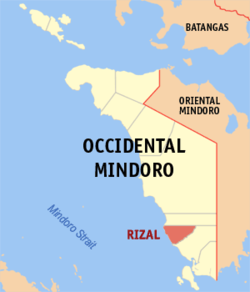
Map of Occidental Mindoro with Rizal highlighted
OpenStreetMap
Rizal, Occidental Mindoro
Philippines location map (square).svg
Red pog.svg
Rizal
Location within the Philippines
Coordinates: 12°28′N120°58′E / 12.47°N 120.97°E / 12.47; 120.97
CountryPhilippines
Region Mimaropa
Province Occidental Mindoro
District Lone district
Founded April 3, 1969
Named after José Rizal
Barangays 11 (see Barangays)
Government
[1]
  Type Sangguniang Bayan
   Mayor Ernesto C. Pablo Jr.
   Vice Mayor Marcelino B. Dela Cruz
   Representative Leody “Odie”F. Tarriela
   Municipal Council
Members
  • Aries O. Valdez
  • Alexis James N. Guevarra
  • Restituto F. Awit
  • Ferdinand H. Arca Sr.
  • Edgardo C. Tamboong
  • Carmela S. Ovalles
  • Danilo E. Espartero
  • Ronar A. Hitones
   Electorate 25,125 voters (2025)
Area
[2]
  Total
242.50 km2 (93.63 sq mi)
Elevation
5.0 m (16.4 ft)
Highest elevation
53 m (174 ft)
Lowest elevation
0 m (0 ft)
Population
 (2024 census) [3]
  Total
40,319
  Density170/km2 (430/sq mi)
   Households
9,622
Economy
   Income class 3rd municipal income class
   Poverty incidence
30.07
% (2021) [4]
   Revenue 240.2 million (2022)
   Assets 419.4 million (2022)
   Expenditure 204 million (2022)
   Liabilities 126.6 million (2022)
Service provider
  ElectricityOccidental Mindoro Electric Cooperative (OMECO)
Time zone UTC+8 (PST)
ZIP code
5103
PSGC
IDD : area code +63(0)43
Native languages Ratagnon
Tagalog

Rizal, officially the Municipality of Rizal (Tagalog : Bayan ng Rizal), is a municipality in the province of Occidental Mindoro, Philippines. According to the 2020 census, it has a population of 40,429 people. [5]

Contents

Rizal is 153 kilometres (95 mi) from Mamburao.

History

Before the coming of the Spaniards to the Philippines, the area which comprises Rizal was covered with forests. Later on, a few families of tribal Filipinos, known as Ratagnons, settled near the mouth of a river which was called Bogsanga. According to the Hanunoos, another group of tribal Filipinos, living on the hills, about ten kilometers west of Bogsanga, the original name of the river was Bisanga, a word from their dialect which means "It branched out." They gave the river that name for the said body of water came from two sources.

Political leaders of San Jose, Occidental Mindoro felt that the barrios between Busuanga and Lumintao River should be created as another municipality. In anticipation of the creation of a new town, residents of Barrio Limlim decided to change the name of their community to Rizal. They expressed their desire that their barrio would be made as the center of the town.

When Pedro Medalla Sr. was elected in 1965 as representative of Occidental Mindoro, one of the bills he filed in Congress was the creation of the municipality of Rizal. Through his effort, Republic Act No. 5460 was passed by Congress and signed into law by President Ferdinand Marcos. Rizal became a municipality on April 3, 1969. Ten barrios composed the new town. They were Adela, Rumbang, Salvacion, Magui, Magsikap, San Pedro, Santo Nino, Pitogo, Aguas and Rizal (Limlim).

Geography

Barangays

Rizal is politically subdivided into 11 barangays. Each barangay consists of puroks and some have sitios.

  • Adela
  • Aguas
  • Magsikap
  • Malawaan
  • Pitogo
  • Rizal
  • Rumbang
  • Salvacion
  • San Pedro
  • Santo Niño
  • Manoot

Climate

Climate data for Rizal, Occidental Mindoro
MonthJanFebMarAprMayJunJulAugSepOctNovDecYear
Mean daily maximum °C (°F)30
(86)
31
(88)
32
(90)
32
(90)
32
(90)
31
(88)
30
(86)
29
(84)
29
(84)
29
(84)
30
(86)
30
(86)
30
(87)
Mean daily minimum °C (°F)21
(70)
21
(70)
22
(72)
22
(72)
24
(75)
25
(77)
25
(77)
25
(77)
25
(77)
24
(75)
23
(73)
22
(72)
23
(74)
Average precipitation mm (inches)30
(1.2)
26
(1.0)
39
(1.5)
58
(2.3)
192
(7.6)
283
(11.1)
341
(13.4)
323
(12.7)
317
(12.5)
231
(9.1)
119
(4.7)
56
(2.2)
2,015
(79.3)
Average rainy days10.38.312.416.323.527.128.427.327.626.319.213.6240.3
Source: Meteoblue [6]

Demographics

Population census of Rizal
YearPop.±% p.a.
1970 12,108    
1975 14,938+4.30%
1980 18,609+4.49%
1990 23,379+2.31%
1995 27,112+2.81%
2000 29,785+2.04%
2007 32,065+1.02%
2010 34,458+2.65%
2015 38,263+2.01%
2020 40,429+1.17%
2024 40,319−0.07%
Source: Philippine Statistics Authority [7] [8] [9] [10] [11]

Economy

Poverty incidence of Rizal

10
20
30
40
50
60
70
2000
62.46
2003
54.97
2006
48.10
2009
36.04
2012
31.16
2015
36.47
2018
21.29
2021
30.07

Source: Philippine Statistics Authority [12] [13] [14] [15] [16] [17] [18] [19]

References

  1. Municipality of Rizal | (DILG)
  2. "2015 Census of Population, Report No. 3 – Population, Land Area, and Population Density" (PDF). Philippine Statistics Authority. Quezon City, Philippines. August 2016. ISSN   0117-1453. Archived (PDF) from the original on May 25, 2021. Retrieved July 16, 2021.
  3. "2024 Census of Population (POPCEN) Population Counts Declared Official by the President". Philippine Statistics Authority. 17 July 2025. Retrieved 18 July 2025.
  4. "PSA Releases the 2021 City and Municipal Level Poverty Estimates". Philippine Statistics Authority. 2 April 2024. Retrieved 28 April 2024.
  5. "2024 Census of Population (POPCEN) Population Counts Declared Official by the President". Philippine Statistics Authority. 17 July 2025. Retrieved 18 July 2025.
  6. "Rizal: Average Temperatures and Rainfall". Meteoblue. Retrieved 26 April 2020.
  7. "2024 Census of Population (POPCEN) Population Counts Declared Official by the President". Philippine Statistics Authority. 17 July 2025. Retrieved 18 July 2025.
  8. Census of Population (2015). "Region IV-B (Mimaropa)". Total Population by Province, City, Municipality and Barangay. Philippine Statistics Authority . Retrieved 20 June 2016.
  9. Census of Population and Housing (2010). "Region IV-B (Mimaropa)" (PDF). Total Population by Province, City, Municipality and Barangay. National Statistics Office . Retrieved 29 June 2016.
  10. Censuses of Population (1903–2007). "Region IV-B (Mimaropa)". Table 1. Population Enumerated in Various Censuses by Province/Highly Urbanized City: 1903 to 2007. National Statistics Office.
  11. "Province of". Municipality Population Data. Local Water Utilities Administration Research Division. Retrieved 17 December 2016.
  12. "Poverty incidence (PI):". Philippine Statistics Authority. Retrieved December 28, 2020.
  13. "Estimation of Local Poverty in the Philippines" (PDF). Philippine Statistics Authority. 29 November 2005.
  14. "2003 City and Municipal Level Poverty Estimates" (PDF). Philippine Statistics Authority. 23 March 2009.
  15. "City and Municipal Level Poverty Estimates; 2006 and 2009" (PDF). Philippine Statistics Authority. 3 August 2012.
  16. "2012 Municipal and City Level Poverty Estimates" (PDF). Philippine Statistics Authority. 31 May 2016.
  17. "Municipal and City Level Small Area Poverty Estimates; 2009, 2012 and 2015". Philippine Statistics Authority. 10 July 2019.
  18. "PSA Releases the 2018 Municipal and City Level Poverty Estimates". Philippine Statistics Authority. 15 December 2021. Retrieved 22 January 2022.
  19. "PSA Releases the 2021 City and Municipal Level Poverty Estimates". Philippine Statistics Authority. 2 April 2024. Retrieved 28 April 2024.