Palawan, officially the Province of Palawan, is an archipelagic province of the Philippines that is located in the region of Mimaropa. It is the largest province in the country in terms of total area of 14,649.73 km2 (5,656.29 sq mi). The capital and largest city is Puerto Princesa wherein it is geographically grouped but administered independently from the province. Palawan is known as the Philippines' Last Frontier and as the Philippines' Best Island.

Busuanga, officially the Municipality of Busuanga, is a 3rd class municipality in the province of Palawan, Philippines. According to the 2020 census, it has a population of 25,617 people.

Coron, officially the Municipality of Coron, is a 1st class municipality in the province of Palawan, Philippines. According to the 2020 census, it has a population of 65,855 people.

Coron is the third-largest island in the Calamian Islands in northern Palawan in the Philippines. The island is part of the larger municipality of the same name. It is about 170 nautical miles (310 km) southwest of Manila and is known for several Japanese shipwrecks of World War II vintage. Because of its unique ecological features, the entire area is protected by several legal proclamations.
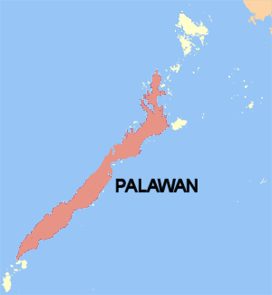
Palawan is the largest island of the province of Palawan in the Philippines and fifth-largest by area and tenth-most populous island of the country, with a total population of 994,101 as of 2020 census. The north west coast of the island is along the South China Sea, while the south east coast forms part of the northern limit of the Sulu Sea. Much of the island remains traditional and is considered by some as under-developed. Abundant wildlife, jungle mountains, and some white sandy beaches attract many tourists, as well as international companies looking for development opportunities.

Culion, officially the Municipality of Culion, is a 3rd class municipality in the province of Palawan, Philippines. According to the 2020 census, it has a population of 23,213 people.

Palawan, the largest province in the Philippines, is home to several indigenous ethnolinguistic groups namely, the Kagayanen, Tagbanwa, Palawano, Taaw't Bato, Molbog, and Batak tribes. They live in remote villages in the mountains and coastal areas.

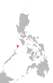
The Calamian Islands or the Calamianes is a group of islands in the province of Palawan, Philippines. It includes:

Sangat Island is a tiny island in the Philippines situated 2 kilometres (1.2 mi) off the coast of Busuanga close to Barangay Bintuan, Coron in the northern part of the Calamian Islands in the province of Palawan in the Philippines. The Calamian Islands are known for their many natural attractions and is a popular attraction for tourists and cruise lines.

Nepenthes philippinensis is a tropical pitcher plant endemic to the Philippines. It is known from Palawan and the neighbouring Calamian Islands and Linapacan, where it grows at 0–600 metres (2,000 ft) above sea level.

Francisco B. Reyes Airport, more commonly known as Busuanga Airport, is an airport serving the general area of Coron, located in Busuanga Island in the province of Palawan, Philippines. It is also shared with the neighboring municipality of Busuanga, located on the western half of the island. Since November 10, 2008, the airport has been named after Francisco B. Reyes, the mayor of Coron from 1936 to 1939 who donated the land that forms the current airport complex.

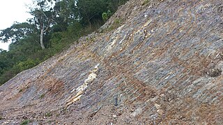
Radiolarite is a siliceous, comparatively hard, fine-grained, chert-like, and homogeneous sedimentary rock that is composed predominantly of the microscopic remains of radiolarians. This term is also used for indurated radiolarian oozes and sometimes as a synonym of radiolarian earth. However, radiolarian earth is typically regarded by Earth scientists to be the unconsolidated equivalent of a radiolarite. A radiolarian chert is well-bedded, microcrystalline radiolarite that has a well-developed siliceous cement or groundmass.
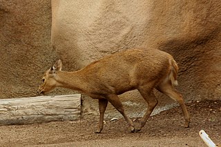
The Calamian deer, also known as Calamian hog deer, is an endangered species of deer found only in the Calamian Islands of Palawan province in the Philippines. It is one of three species of deer native to the Philippines, the other being the Philippine sambar and the Visayan spotted deer.

West Nalaut Island is an island in northern Palawan, in the Philippines. It is the westernmost of the Calamian Islands, and can form a guide to shipping entering the Coron West Passage. It is approximately 16 kilometres (9.9 mi) off the western coast of Busuanga Island, which is approximately a 40-minute flight from Manila. The uninhabited 47.9-hectare (0.479 km2) island is privately owned. It was attempted to be sold as part of the HGTV show "Island Hunters".
Calamian Tagbanwa is spoken in the Calamian Islands just north of Palawan Island, Philippines. It is not mutually intelligible with the other languages of the Tagbanwa people. Ethnologue reports that it is spoken in Busuanga, Coron, Culion, and Linapacan municipalities.

North Palawan Block is a microcontinental block situated in the western Philippines and the southern tip of the Manila Trench. The North Palawan block is considered to form the northeastern portion of a much larger area of block faulted and foundered pre-Tertiary continental material which extends throughout the southern part of the South China Sea Basin and includes the Spratly Islands and the Dangerous Grounds area off Borneo. The evidence for the continental composition of the crust of this area is substantial and has been reviewed by Hamilton (1979) and Taylor & Hayes (1980) among others.

The geology of Bosnia & Herzegovina is the study of rocks, minerals, water, landforms and geologic history in the country. The oldest rocks exposed at or near the surface date to the Paleozoic and the Precambrian geologic history of the region remains poorly understood. Complex assemblages of flysch, ophiolite, mélange and igneous plutons together with thick sedimentary units are a defining characteristic of the Dinaric Alps, also known as the Dinaride Mountains, which dominate much of the country's landscape.

The geology of Moldova encompasses basement rocks from the Precambrian dating back more than 2.5 billion years, overlain by thick sequences of Proterozoic, Paleozoic, Mesozoic and Cenozoic sedimentary rocks.

The geology of Kazakhstan includes extensive basement rocks from the Precambrian and widespread Paleozoic rocks, as well as sediments formed in rift basins during the Mesozoic.
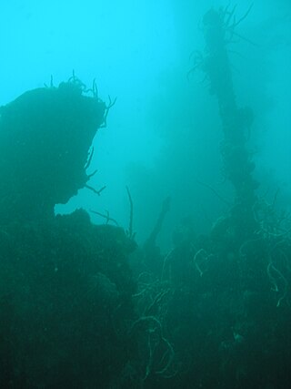
Coron Bay is a well-known recreational diving region in the Sulu Sea in the western Philippines, between the islands of Coron and Busuanga in the Calamian Islands. Most of Coron Bay is in the Coron Island Protected Area and is a traditional fishing area of the indigenous Tagbanwa tribe.