
The following outline is provided as an overview of and topical guide to the Philippines:
Contents
- General reference
- Geography of the Philippines
- Environment of the Philippines
- Island groups of the Philippines
- Administrative divisions of the Philippines
- Demographics of the Philippines
- Climate of the Philippines
- History of the Philippines
- Period-coverage
- Presidents of the Philippines
- Government and politics of the Philippines
- National government of the Philippines
- Local government in the Philippines
- Foreign relations of the Philippines
- Military of the Philippines
- Intelligence agencies
- Law of the Philippines
- Culture of the Philippines
- Art in the Philippines
- Languages of the Philippines
- Sports in the Philippines
- Education in the Philippines
- Economy and infrastructure of the Philippines
- Energy in the Philippines
- Transportation in the Philippines
- See also
- Notes
- References
- External links
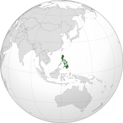
Philippines – archipelagic country in Southeast Asia. In the western Pacific Ocean, it consists of 7,641 islands which are broadly categorized in three main geographical divisions from north to south: Luzon, Visayas, and Mindanao. The Philippines is bounded by the South China Sea to the west, the Philippine Sea to the east, and the Celebes Sea to the south. It shares maritime borders with Taiwan to the north, Japan to the northeast, Palau to the east and southeast, Indonesia to the south, Malaysia to the southwest, Vietnam to the west, and China to the northwest.


