Tangub

Last updated

Tangub
City of Tangub
Tangub City Hall front (J. Luna, Tangub, Misamis Occidental; 10-15-2023).jpg
Tangub City Hall
Sinanduloy Cultural Center (Independencia, Tangub, Misamis Occidental; 10-15-2023).jpg
People's Gymnasium
Tangub City proper, First Street (Tangub, Misamis Occidental; 10-15-2023).jpg
First Street
Tangub City Sports Complex.jpg
Tangub City Sports Complex
Flag of Tangub, Misamis Occidental.png
Tangub-City-PH-official-seal.png
Nicknames: 
  • Christmas Symbols Capital of the Philippines
  • God-Centered City
Motto(s): 
Una ang Ginoo (Cebuano)
'God comes First'
Ph locator misamis occidental tangub.png
Map of Misamis Occidental with Tangub highlighted
OpenStreetMap
Tangub
Philippines location map (square).svg
Red pog.svg
Tangub
Location within the Philippines
Coordinates: 8°04′00″N123°45′00″E / 8.06666667°N 123.75°E / 8.06666667; 123.75
CountryPhilippines
Region Northern Mindanao
Province Misamis Occidental
District 2nd district
Founded December 4, 1929
CityhoodJune 17, 1967
Barangays 55 (see Barangays)
Government
[1]
  Type Sangguniang Panlungsod
   Mayor Sabiniano "Ben" S. Canama (Asenso Pinoy Party)
   Vice Mayor Tito B. Decina (Asenso Pinoy Party)
   Representative Sancho Fernando "Ando" F. Oaminal (Lakas)
   City Council
Members
  • Antonio S. Caylan Jr. (ASPIN)
  • Lowida L. Alcalde (ASPIN)
  • Francisco I. Chiong Jr. (ASPIN)
  • Rose Nason-Buenafe (NP)
  • Hipolito G. Roxas Jr. (ASPIN)
  • Rubin R. Roma (ASPIN)
  • Leonido C. Tala Sr. (ASPIN)
  • Marissa V. Amamio (ASPIN)
  • Romulo L. Del Socorro (ASPIN)
  • Alexander M. Returerto (ASPIN)
   Electorate 46,336 voters (2025)
Area
[2]
  Total
162.78 km2 (62.85 sq mi)
Elevation
243 m (797 ft)
Highest elevation
2,421 m (7,943 ft)
Lowest elevation
0 m (0 ft)
Population
 (2024 census)
  Total
68,419
  Density420.32/km2 (1,088.6/sq mi)
   Households
15,456
Economy
   Income class 3rd city income class
   Poverty incidence
27.33
% (2021)
   Revenue 922.4 million (2022)
   Assets 2,585 million (2022)
   Expenditure 607 million (2022)
   Liabilities 617.8 million (2022)
Service provider
  ElectricityMisamis Occidental 2 Electric Cooperative (MOELCI 2)
Time zone UTC+8 (PST)
ZIP code
7214
PSGC
IDD : area code +63(0)88
Native languages Subanon
Cebuano
Tagalog
Feast dateSeptember 29
Catholic diocese Archdiocese of Ozamis
Patron saint Michael the Archangel
Website tangubcity.gov.ph

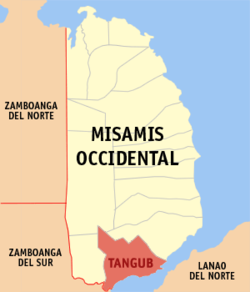
Tangub, officially the City of Tangub (Cebuano : Dakbayan sa Tangub; Filipino : Lungsod ng Tangub), is a component city in the province of Misamis Occidental, Philippines. According to the 2024 census, it has a population of 68,419 people.

Contents

Tangub City is also where the Panguil Bay Bridge is situated. The 3.77 km (2.34 mi) bridge connects Tangub, Misamis Occidental to Tubod, Lanao del Norte.

History

During the Spanish colonial period of the Philippines, Tangub was recorded in Spanish maps as the barrio of Tan͠go. [3] In the early 1900s, the name Tango is also recorded in maps and publications during the Philippine-American War. [4] [5]

The book A Pronouncing Gazetteer and Geographical Dictionary of the Philippine Islands (1902) by the Bureau of Insular Affairs records Tan͠gó as a "hamlet on northwestern shore of Panguil Bay, 3 miles southwest of Misamis, Misamis, Mindanao." The book also records its pronunciation as having a final glottal stop (tahng-oh'). [6]

The 1918 Philippine census records it as "Tangob," a barrio in the municipality of Misamis in the former province of Misamis. [7]

The etymology of the name Tangub is unknown. According to local folk etymology, it came from the Subanen word "Tangkub", a rice container made of tree bark woven together by rattan strips, [8] but this has no academic evidence.

As a municipality

By the 1920s, there was increasing support for the independence of Tangob from Misamis as its own municipality, advocated in particular by a local group, the Aspiracion Committee. [8]

The municipality of Regidor (with its seat of government in the barrio of Tangob) was created through Executive Order (EO) No. 220, issued by Governor General Dwight F. Davis on December 4, 1929, which organized 14 barrios —separated from Misamis—into the 21st municipality of the once undivided Misamis province. [9] [10] The municipality was named after Antonio Maria Regidor  [ tl ], a lawyer and reformist who supported the Secularization movement against the Spanish colonial regime. Similar new municipalities created during the same period were also named after prominent revolutionaries, including Lopez Jaena and General Luna. [8] [11]

However, its organization only took effect on January 1, 1930, the same day the province of Occidental Misamis was established following the split of Misamis. [12] By Act No. 3701 dated November 20, the municipality was renamed Tangub. [13]

In 1940, six of its barrios were organized into the separate municipality of Bonifacio by the virtue of EO No. 242. [14]

Cityhood

On June 17, 1967, under Republic Act No. 5131, Tangub became a chartered city, [15] the second in Misamis Occidental.

Geography

Tangub is close to Zamboanga del Sur and Zamboanga del Norte provinces, while across the bay is Lanao del Norte. Tangub is 77.1 km (77,100 mi) from Maria Cristina Falls, the main source of hydroelectric power in Mindanao.

Barangays

Tangub is politically subdivided into 55 barangays. Each barangay consists of puroks while some have sitios.

  • Silanga
  • Marcos (Aquino)
  • Santa Maria (Baga)
  • Balatacan
  • Baluk
  • Banglay
  • Mantic
  • Mingcanaway
  • Bintana
  • Bocator
  • Bongabong
  • Caniangan
  • Capalaran
  • Catagan
  • Barangay I - City Hall (Poblacion)
  • Barangay II - Marilou Annex (Poblacion)
  • Barangay IV - St. Michael (Poblacion)
  • Isidro D. Tan (Dimalooc)
  • Garang
  • Guinabot
  • Guinalaban
  • Hoyohoy
  • Kauswagan
  • Kimat
  • Labuyo
  • Lorenzo Tan
  • Barangay VI - Lower Polao (Poblacion)
  • Lumban
  • Maloro
  • Barangay V - Malubog (Poblacion)
  • Manga
  • Maquilao
  • Barangay III- Market Kalubian (Poblacion)
  • Matugnao
  • Minsubong
  • Owayan
  • Paiton
  • Panalsalan
  • Pangabuan
  • Prenza
  • Salimpuno
  • San Antonio
  • San Apolinario
  • San Vicente
  • Santa Cruz
  • Santo Niño
  • Sicot
  • Silanga
  • Silangit
  • Simasay
  • Sumirap
  • Taguite
  • Tituron
  • Tugas
  • Barangay VII - Upper Polao (Poblacion)
  • Villaba

Climate

Climate data for Tangub City, Misamis Occidental
MonthJanFebMarAprMayJunJulAugSepOctNovDecYear
Mean daily maximum °C (°F)29
(84)
30
(86)
31
(88)
31
(88)
30
(86)
30
(86)
29
(84)
30
(86)
30
(86)
30
(86)
30
(86)
30
(86)
30
(86)
Mean daily minimum °C (°F)22
(72)
22
(72)
22
(72)
23
(73)
24
(75)
24
(75)
24
(75)
24
(75)
24
(75)
24
(75)
23
(73)
23
(73)
23
(74)
Average precipitation mm (inches)69
(2.7)
58
(2.3)
67
(2.6)
60
(2.4)
109
(4.3)
114
(4.5)
83
(3.3)
78
(3.1)
76
(3.0)
92
(3.6)
86
(3.4)
63
(2.5)
955
(37.7)
Average rainy days12.811.614.817.424.823.520.718.517.422.521.615.6221.2
Source: Meteoblue [16]

Demographics

Population census of Tangub
YearPop.±% p.a.
1939 44,743    
1948 20,353−8.38%
1960 21,101+0.30%
1970 30,918+3.89%
1975 40,461+5.54%
1980 40,401−0.03%
1990 42,926+0.61%
1995 46,004+1.31%
2000 49,695+1.67%
2007 56,644+1.82%
2010 59,892+2.05%
2015 63,011+0.97%
2020 68,389+1.74%
2024 68,419+0.01%
Source: Philippine Statistics Authority [17] [18] [19] [20]

In the 2024 census, the population of Tangub was 68,419 people, with a density of 420 inhabitants per square kilometre or 1,100 inhabitants per square mile.

Economy

Poverty incidence of Tangub

10
20
30
40
50
60
70
2000
50.60
2003
57.15
2006
63.80
2009
43.08
2012
39.32
2015
35.47
2018
27.50
2021
27.33

Source: Philippine Statistics Authority [21] [22] [23] [24] [25] [26] [27] [28]

Culture

Notable events and festivals

The Sinanduloy Cultural Troupe in the Sinulog 2020 Festival Queen of Sinanduloy.jpg
The Sinanduloy Cultural Troupe in the Sinulog 2020 Festival

Tangub, through its Sinanduloy Cultural Troupe, was a regular participant of the Sinulog Festival, a festival held in Cebu City. This festival is the pageantry of sights, sounds and colors as it honors and pays homage to Sr. Santo Niño, the child Jesus. The highlights of the festival is from January 9–18, yearly. Tangub City has won a record of twelve grand champion streak in the Sinulog-Based Category of the festival.

Through the recent years, Tangub has been popularly dubbed as the Christmas Symbols Capital of the Philippines. Every year, the city will celebrate Christmas through the Tangub City Christmas Festival of Lights. During the month-long festival, the city fills with a delightful array of illuminated holiday decor, bathing the streets in a most enticing glow.

The city also has a festival called the Dalit Cultural Festivial. It is held in honor of the city's patron saint, Saint Michael the Archangel. It is celebrated every September 29-the feast day of Michaelmas. It is participated by the city's barangays through clusters represented by local schools.

The Harvest Festival showcases various agricultural products for selling and promotion. The festival is a venue to promote the agri-tourism program of the city, creating business-matching opportunities for the people of Tangub City.

Tourism

Hoyohoy Highland Stone Chapel Adventure Park Hoyohoy Adventure Park2.jpg
Hoyohoy Highland Stone Chapel Adventure Park

Government

Old seal of the city, NHCP version Tangub Misamis Occidental.png
Old seal of the city, NHCP version
Leadership

Tangub City Officials 2025-2028:

Sister cities

See also

References

  1. City of Tangub | (DILG)
  2. "2015 Census of Population, Report No. 3 – Population, Land Area, and Population Density" (PDF). Philippine Statistics Authority. Quezon City, Philippines. August 2016. ISSN   0117-1453. Archived (PDF) from the original on May 25, 2021. Retrieved July 16, 2021.
  3. Aligué, José (1899). Atlas de Filipinas: Coleccion de 30 Mapas.
  4. Wilcox, Marrion (1900). Harper's History of the War in the Philippines. Harper & Brothers. p. 432.
  5. Progress map of Signal Corps telegraph lines and cables in the Military Division of the Philippines. Washington: United States Army Signal Corps. 1903.
  6. Bureau of Insular Affairs, War Department (1902). A Pronouncing Gazetteer and Geographical Dictionary of the Philippine Islands. U.S. Government Printing Office. p. 870.
  7. Census Office of the Philippine Islands (1920). Census of the Philippine Islands 1918: Volume I - Geography, History, and Climatology. Manila: Bureau of Printing. p. 604.
  8. 1 2 3 "History of the City" . Retrieved February 12, 2024.
  9. Executive Orders and Proclamations, 1929. Manila: Bureau of Printing. 1930. pp. 106–108. Retrieved September 13, 2025 via Internet Archive.
  10. Annual Report of the Governor General of the Philippine Islands, 1929. Washington, D.C.: U.S. Government Printing Office. 1931. p. 30. Retrieved September 13, 2025 via Google Books.
  11. Annual Report of the Governor General of the Philippine Islands 1929. Government Printing Office. 1931. p. 30.
  12. Annual Report of the Governor General of the Philippine Islands, 1930. Washington, D.C.: U.S. Government Printing Office. 1932. p. 49. Retrieved September 13, 2025 via Google Books.
  13. Act No. 3701 (November 20, 1930), An Act Changing the Present Name of the Municipality of Regidor, Occidental Misamis, to Tangub , retrieved September 13, 2025
  14. Executive Order No. 242, s. 1939 (December 28, 1939), Organizing a Certain Portion of the Municipality of Tangub, Misamis Occidental, into a Regular Municipality under the Name of Bonifacio , retrieved September 13, 2025
  15. Republic Act No. 5131 (June 17, 1967), The Charter of the City of Tangub , retrieved September 13, 2025
  16. "Tangub: Average Temperatures and Rainfall". Meteoblue. Retrieved April 29, 2020.
  17. Census of Population (2015). "Region X (Northern Mindanao)". Total Population by Province, City, Municipality and Barangay. Philippine Statistics Authority . Retrieved June 20, 2016.
  18. Census of Population and Housing (2010). "Region X (Northern Mindanao)" (PDF). Total Population by Province, City, Municipality and Barangay. National Statistics Office . Retrieved June 29, 2016.
  19. Censuses of Population (1903–2007). "Region X (Northern Mindanao)". Table 1. Population Enumerated in Various Censuses by Province/Highly Urbanized City: 1903 to 2007. National Statistics Office.
  20. "Province of Misamis Occidental". Municipality Population Data. Local Water Utilities Administration Research Division. Retrieved December 17, 2016.
  21. "Poverty incidence (PI):". Philippine Statistics Authority. Retrieved December 28, 2020.