This article needs additional citations for verification .(June 2014) |
Kitaotao | |
|---|---|
| Municipality of Kitaotao | |
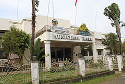 Municipal hall | |
 Flag  Seal | |
Nicknames:
| |
 Map of Bukidnon with Kitaotao highlighted | |
OpenStreetMap  | |
 Kitaotao Location within the Philippines | |
| Coordinates: 7°38′26″N125°00′31″E / 7.6406°N 125.0086°E | |
| Country | Philippines |
| Region | Northern Mindanao |
| Province | Bukidnon |
| District | 3rd district |
| Founded | June 18, 1966 |
| Barangays | 35 (see Barangays) |
| Government | |
| • Type | Sangguniang Bayan |
| • Mayor | Edwin P. Abucayan |
| • Vice Mayor | Mary Ann G. Angit |
| • Representative | Audrey Zubiri |
| • Municipal Council | Members |
| • Electorate | 33,801 voters (2025) |
| Area | |
• Total | 788.78 km2 (304.55 sq mi) |
| Elevation | 327 m (1,073 ft) |
| Highest elevation | 393 m (1,289 ft) |
| Lowest elevation | 219 m (719 ft) |
| Population (2024 census) [3] | |
• Total | 57,364 |
| • Density | 73/km2 (190/sq mi) |
| • Households | 12,835 |
| Economy | |
| • Income class | 1st municipal income class |
| • Poverty incidence | 37.59 |
| • Revenue | ₱ 417.8 million (2022) |
| • Assets | ₱ 902.7 million (2022) |
| • Expenditure | ₱ 286.9 million (2022) |
| • Liabilities | ₱ 237.6 million (2022) |
| Service provider | |
| • Electricity | First Bukidnon Electric Cooperative (FIBECO) |
| Time zone | UTC+8 (PST) |
| ZIP code | 8716 |
| PSGC | |
| IDD : area code | +63 (0)88 |
| Native languages | Western Bukidnon Manobo Binukid Cebuano Ata Manobo Tagalog |
| Website | www |
Kitaotao, officially the Municipality of Kitaotao (Cebuano : Lungsod sa Kitaotao; Tagalog : Bayan ng Kitaotao), is a municipality in the province of Bukidnon, Philippines. According to the 2020 census, it has a population of 53,796 people. [5]